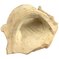
1 of 4
Ancient Mediterranean Pottery Handle Fragments Amphora Set of 3
$129List Priceper set
About the Item
- Dimensions:Height: 2.5 in (6.35 cm)Width: 3 in (7.62 cm)Depth: 4 in (10.16 cm)
- Sold As:Set of 3
- Materials and Techniques:
- Period:
- Date of Manufacture:antiquity
- Condition:Wear consistent with age and use. overall wear.
- Seller Location:Seguin, TX
- Reference Number:1stDibs: LU7228239295892
Authenticity Guarantee
In the unlikely event there’s an issue with an item’s authenticity, contact us within 1 year for a full refund. DetailsMoney-Back Guarantee
If your item is not as described, is damaged in transit, or does not arrive, contact us within 7 days for a full refund. Details24-Hour Cancellation
You have a 24-hour grace period in which to reconsider your purchase, with no questions asked.Vetted Professional Sellers
Our world-class sellers must adhere to strict standards for service and quality, maintaining the integrity of our listings.Price-Match Guarantee
If you find that a seller listed the same item for a lower price elsewhere, we’ll match it.Trusted Global Delivery
Our best-in-class carrier network provides specialized shipping options worldwide, including custom delivery.You May Also Like
Roman Clay Jar Handle Fragment
Located in Miami, FL
Roman clay fragment, this is the remains of the jar handle.
This fragment was found in one of France's oldest ports, Fos-sur-Mer, not far from Arles whe...
Category
Antique 15th Century and Earlier French Jars
Materials
Clay
Vintage 1970s Orioli Ceramic Amphora - Italian Mid-Century Modern Pottery
Located in Manzano, IT
Vintage 1970s Orioli Ceramic Amphora - Italian Mid-Century Modern Pottery
This exquisite single-handle ceramic amphora, crafted by the renowned Italian ceramics maker Orioli in the ...
Category
Vintage 1970s Italian Nautical Objects
Materials
Ceramic
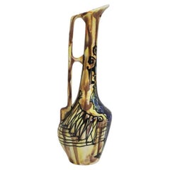
$295 Sale Price
44% Off
H 11.82 in W 3.94 in D 4.34 in
Mediterranean Tapestry: A 19th Century Map of the Mediterranean Shores, 1882
Located in Langweer, NL
This map, titled "The Shores of the Mediterranean," is part of the 1882 atlas by Blackie & Son, and it portrays the coastal regions that surround the Mediterranean Sea. It is a detailed representation of the diverse and historically rich countries that share the Mediterranean coastline, spanning from the Strait of Gibraltar in the west to the Levantine Sea in the east, and from the southern shores of Europe down to the northern coastlines of Africa.
The map is a vivid document of the time, with each country along the Mediterranean basin meticulously outlined. The northern coast includes the southern parts of Europe, featuring Spain...
Category
Antique 1880s Maps
Materials
Paper
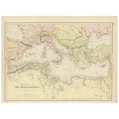
$269 Sale Price
20% Off
H 11.03 in W 14.97 in D 0 in
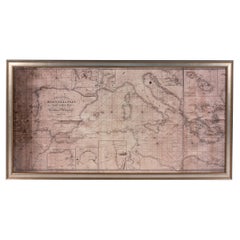
Large Framed Map of the Mediterranean
Located in Queens, NY
Large map/chart chart of The Mediterranean and the Grecian Archipelago showing Italy, Sardinia, Corsica, part of France, etc. in a black frame.
Category
20th Century French Mid-Century Modern Maps
American Pottery and Glass Book Collection - Set of 5
Located in Bradenton, FL
A set of five books on American pottery and glass.
1. Lehner's Encyclopedia of U.S. Marks on Pottery, Porcelain & Clay.
2. Collector's Encyclopedia of Depression Glass.
3. Frankoma ...
Category
Late 20th Century American Books
Materials
Paper

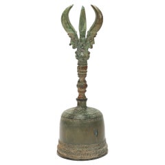
Ancient Bronze Buddhist Ghanta Hand Bell with Vajra / Dorje Handle
Located in Philadelphia, PA
A fine ancient bronze ghanta bell.
In a Buddhist style.
With engraved and embossed geometric decoration to the bell body.
The handle with a 3 point vajra device with each point em...
Category
Antique 18th Century Indian Religious Items
Materials
Bronze
Set 5, Ancient Rome, Ancient Greece, Lost Worlds, Middle Ages, Elizab, World
Located in valatie, NY
Set of 5 Books: Ancient Rome, Ancient Greece, Lost Worlds, Middle Ages, Elizabethan World. New York: American Heritage Publishing Co. Ancient Rome: in an age when Latin has become ra...
Category
Vintage 1960s American Books
Materials
Paper
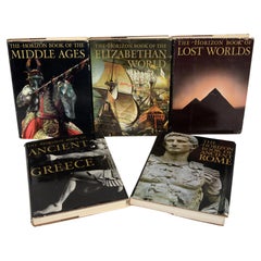
$225 / set
H 12.25 in W 9.25 in D 1.25 in
Antique Plan of Ancient Syracuse, Plan of ancient Syracuse, Sicily, Italy
Located in Langweer, NL
Antique print titled 'Plan de l'Ancienne Ville de Syracuse'. Plan of ancient Syracuse, Sicily, Italy. This print originates from 'Histoire Universelle (..)'.
Artists and Engravers...
Category
Antique 18th Century Maps
Materials
Paper
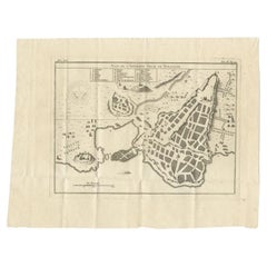
$173 Sale Price
20% Off
H 10.63 in W 13.59 in D 0 in
Set of 8 Mini Pigs Earthenware Pottery Tea Pets Paperweights
Located in Somis, CA
Set of 8 adorable earthenware piggies. Hand crafted depicting happy countenance. Various colors. These cute pieces can be used as paperweights and tea pets.
Category
21st Century and Contemporary Chinese Models and Miniatures
Materials
Earthenware, Pottery
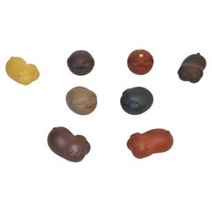
Set of 7 Mini Pigs Earthenware Pottery Tea Pets Paperweights
Located in Somis, CA
Set of 7 adorable earthenware piggies. Hand crafted depicting happy countenance. Various colors. These cute pieces can be used as paperweights and tea pets.
Category
21st Century and Contemporary Chinese Models and Miniatures
Materials
Earthenware, Pottery

$60 Sale Price / set
20% Off
H 1 in W 1.5 in D 2.5 in
Recently Viewed
View AllMore Ways To Browse
Terracotta Fragment
Pottery Fragment
Emancipation Proclamation
Historical Letters
Shackleton Furniture
Signing Declaration Independence
Space Memorabilia
Tree Topper
Used Waterman Pens
Vintage Car Grills
Vintage Post Office Memorabilia
William Sherman
Wwi Memorabilia
Antique Furniture Brooklyn
Antique Indentures
Artillery Shell Casing
Brass Cash Register
German Cameras Vintage