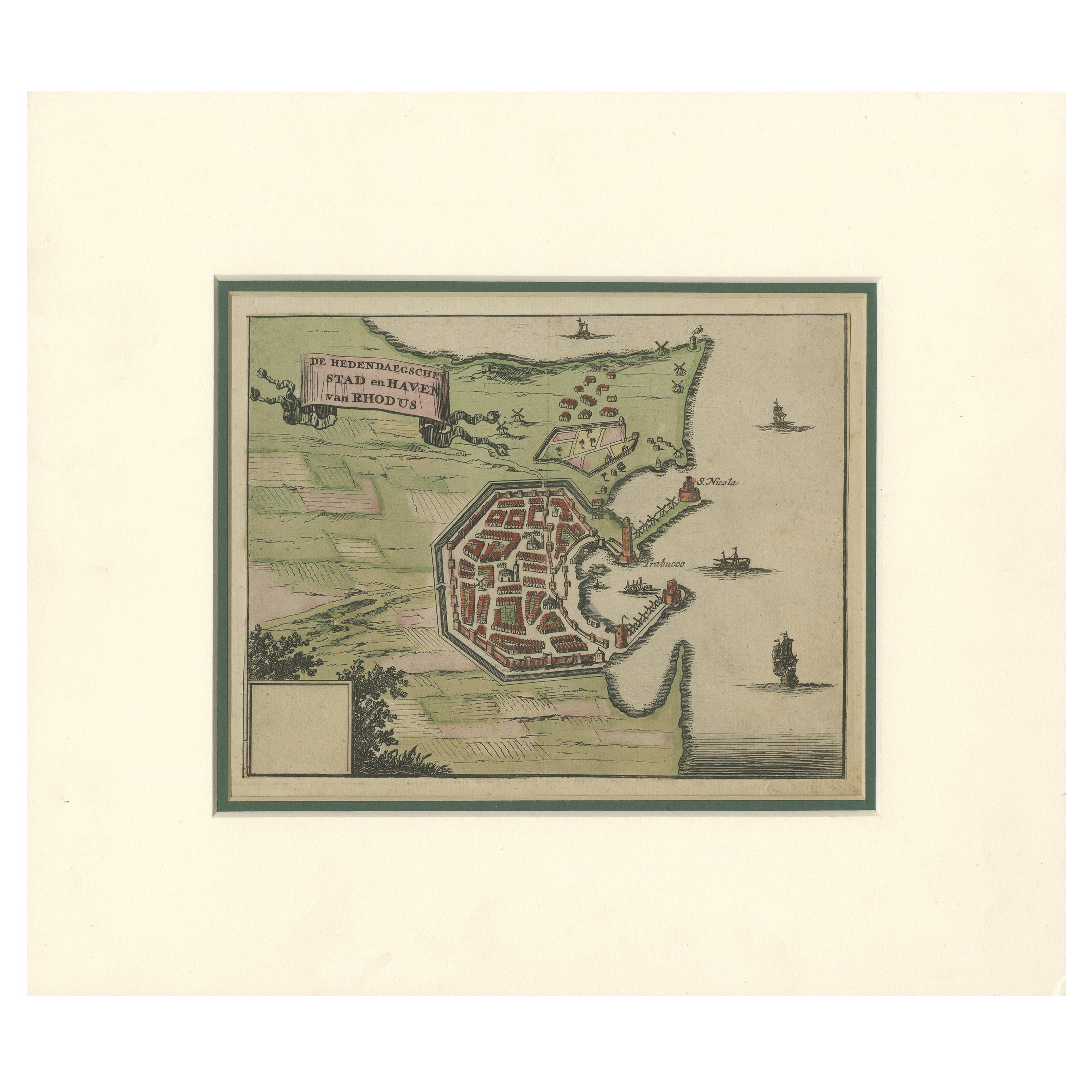
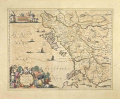
Items Similar to 1687 Engraved View of Rhodes by O. Dapper – Hand-Colored Island of Rhodus


Want more images or videos?
Request additional images or videos from the seller
1 of 10
1687 Engraved View of Rhodes by O. Dapper – Hand-Colored Island of Rhodus
$261.50per item
£194.73per item
€220per item
CA$361.03per item
A$400.26per item
CHF 210.35per item
MX$4,898.51per item
NOK 2,627.08per item
SEK 2,465.77per item
DKK 1,675.01per item
Quantity
About the Item
1687 Engraved View of Rhodes by O. Dapper – Hand-Colored Island of Rhodus
This original antique print is a beautifully detailed copper engraving titled "Het Eylant Rhodus" (The Island of Rhodes), published in Amsterdam in 1687 by Olfert Dapper. It was part of his monumental Dutch-language travel book *"Nauwkeurige Beschrijving der Eilanden in de Archipel der Middellantsche Zee"*, one of the most comprehensive and decorative 17th-century works on the Mediterranean islands.
Depicted here is the island of Rhodes (also known as Rhodus or Rhodos), with its mountainous terrain, fortified towns, and dense maritime traffic. The view is filled with ornate galleons, Ottoman-style ships, cultivated fields, and walled cities—particularly the harbor of Rhodes, once home to the famed Colossus and the Knights Hospitaller. The charming ribbon-style title cartouche and compass rose further enrich the aesthetic appeal.
The scene is both topographic and imaginative, illustrating the strategic significance of Rhodes at the crossroads of Eastern and Western empires. Dapper’s engravings were compiled from a variety of travel reports, and while stylized, they offer valuable insight into how the Dutch viewed and interpreted the wider world in the 17th century.
Condition report :
Very good antique condition. Copperplate engraving with later hand-coloring. Minor age-toning and edge wear. Wide margins and sharp detail.
Framing Tip:
Frame with a museum-grade mat in off-white or parchment tone to complement the age and color palette. A gold or black-and-gilt wood frame adds classical elegance to the historical subject.
- Dimensions:Height: 5.01 in (12.7 cm)Width: 6.26 in (15.9 cm)Depth: 0.01 in (0.2 mm)
- Materials and Techniques:Paper,Engraved
- Place of Origin:
- Period:1680-1689
- Date of Manufacture:1687
- Condition:Additions or alterations made to the original: image mounted to aged paper. Good antique condition. Copperplate engraving with later hand-coloring. Minor age-toning and edge wear. Wide margins and sharp detail. Original image cut short of the margins and mounted to old paper.
- Seller Location:Langweer, NL
- Reference Number:Seller: BG-033301stDibs: LU3054344977612
About the Seller
5.0
Recognized Seller
These prestigious sellers are industry leaders and represent the highest echelon for item quality and design.
Platinum Seller
Premium sellers with a 4.7+ rating and 24-hour response times
Established in 2009
1stDibs seller since 2017
2,609 sales on 1stDibs
Typical response time: <1 hour
- ShippingRetrieving quote...Shipping from: Langweer, Netherlands
- Return Policy
Authenticity Guarantee
In the unlikely event there’s an issue with an item’s authenticity, contact us within 1 year for a full refund. DetailsMoney-Back Guarantee
If your item is not as described, is damaged in transit, or does not arrive, contact us within 7 days for a full refund. Details24-Hour Cancellation
You have a 24-hour grace period in which to reconsider your purchase, with no questions asked.Vetted Professional Sellers
Our world-class sellers must adhere to strict standards for service and quality, maintaining the integrity of our listings.Price-Match Guarantee
If you find that a seller listed the same item for a lower price elsewhere, we’ll match it.Trusted Global Delivery
Our best-in-class carrier network provides specialized shipping options worldwide, including custom delivery.More From This Seller
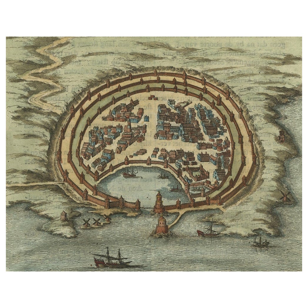
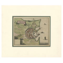
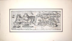
View AllCity and Harbour of Rhodes – Olfert Dapper, 1688 Hand-Coloured Engraving
Located in Langweer, NL
City and Harbour of Rhodes – Olfert Dapper, 1688 Hand-Coloured Engraving
Description:
This historical hand-coloured copperplate engraving, titled “De hedendaegsche Stad en Haven van...
Category
Antique Late 17th Century Dutch Maps
Materials
Paper
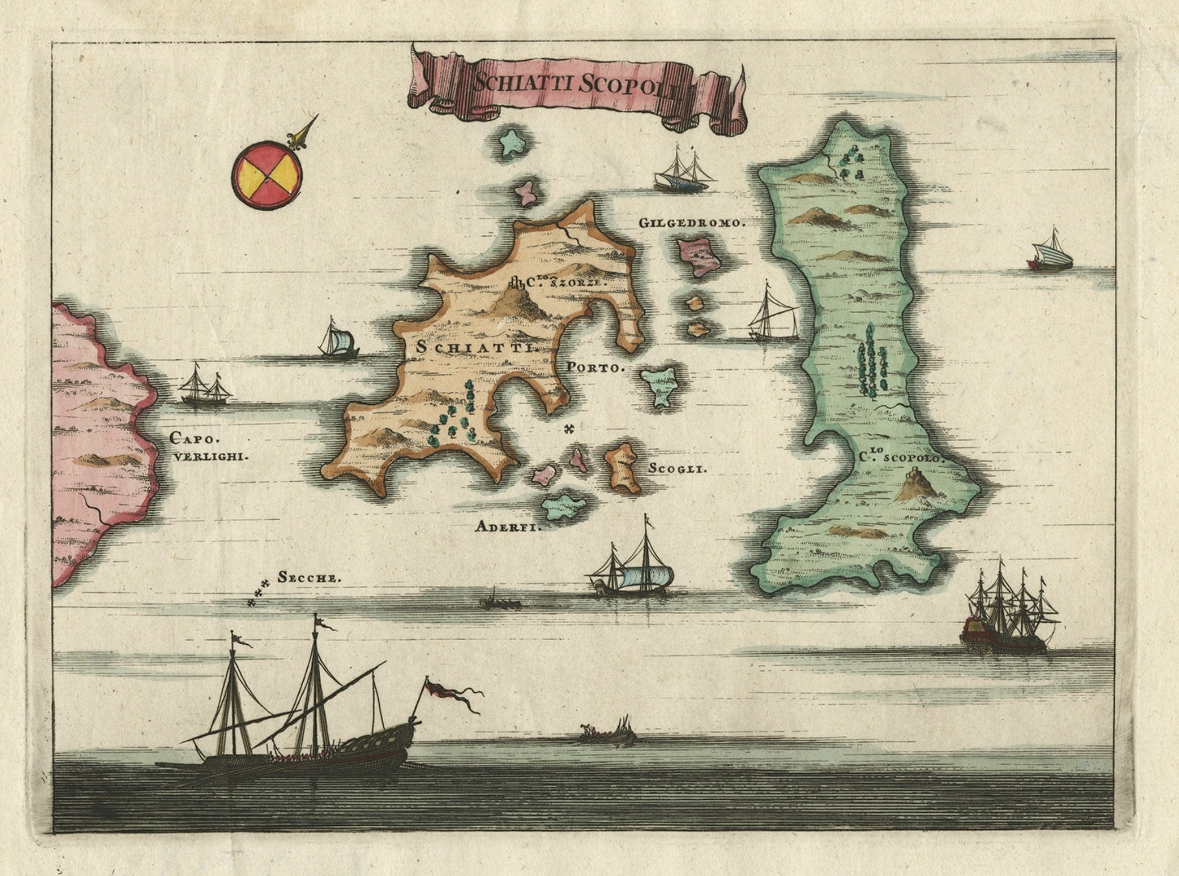
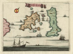
Antique Map of the Islands of Schiatti and Scopoli, Greece, 1687
Located in Langweer, NL
Antique map titled 'Schiatti - Scopoli.' This original antique map shows the islands Schiatti and Scopoli in Greece. Source unknown, to be determined.
Artists and Engravers: Made by...
Category
Antique 17th Century Maps
Materials
Paper
$166 Sale Price
20% Off
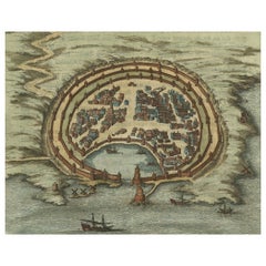
Antique Engraving with a Plan of Rhodes, Greece, 1688
Located in Langweer, NL
Description: Antique map, titled: 'Rhodos.' - Plan of Rhodes, Greece. This map originates from 'Nauwkeurige Beschrijving der eilanden in de in de Archipel der Middellantsche Zee', by...
Category
Antique 1680s Maps
Materials
Paper
$427 Sale Price
20% Off
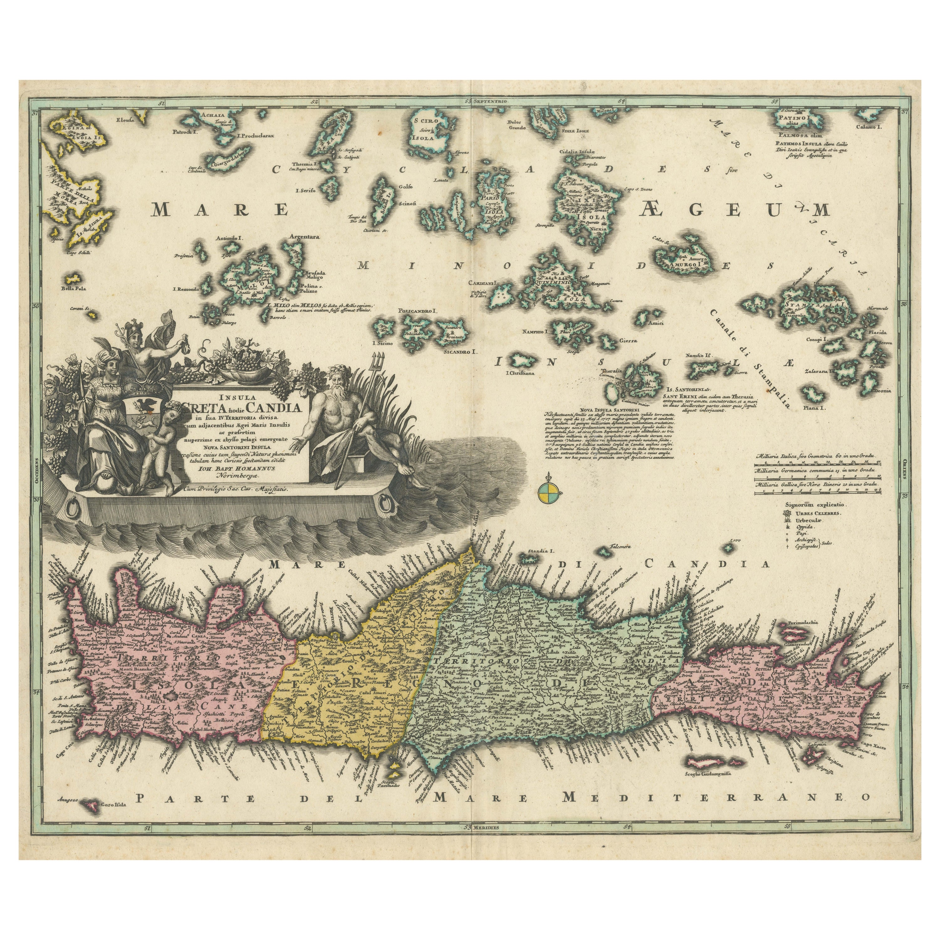
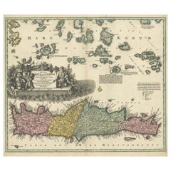
Crete Map 1749 – Homann Heirs Engraving of Candia with Aegean Islands
Located in Langweer, NL
Crete Map 1749 – Homann Heirs Engraving of Candia with Aegean Islands
This fine 1749 map titled 'Insula Creta hodie Candia' presents an 18th-century cartographic portrait of the isl...
Category
Antique 1740s German Maps
Materials
Paper
Antique Map of the Island of Kyra Panagia by Dapper, 1688
Located in Langweer, NL
Antique map titled 'Pelagnisi.' Map of the island of Kyra Panagia, Pelagnisi (Pelagos), Greece. This map originates from 'Nauwkeurige Beschrijving der eilanden in de Archipel der Mid...
Category
Antique 17th Century Maps
Materials
Paper
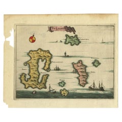
$142 Sale Price
20% Off
Antique Map of the Island of Tinos by Dapper, 1687
Located in Langweer, NL
Antique map titled 'Tino.' This original antique map shows the island of Tinos, Greece. Source unknown, to be determined.
Artists and Engravers: Made by 'Olfert Dapper' after an a...
Category
Antique 17th Century Maps
Materials
Paper
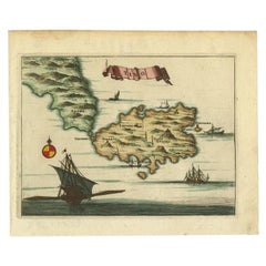
$166 Sale Price
20% Off
You May Also Like
Bermuda: An Early 17th Century Hand-colored Map by Henricus Hondius
By Henricus Hondius
Located in Alamo, CA
This attractive and interesting map of Bermuda by Henricus Hondius in 1633 is entitled "Mappa Aestivarum Insularum, Alias Barmudas". It is based on a ...
Category
Early 17th Century Old Masters Landscape Prints
Materials
Engraving

Antique Map - Mar Di Athiopia - Etching by Johannes Janssonius - 1650s
By Johannes Janssonius
Located in Roma, IT
Antique Map - Mar Di Athiopia is an antique map realized in 1650 by Johannes Janssonius (1588-1664).
The Map is Hand-colored etching, with coeval watercolorang.
Good conditions wit...
Category
1650s Modern Figurative Prints
Materials
Etching

Corfu, Big Antique Map from "Civitates Orbis Terrarum" - 1572-1617
By Franz Hogenberg
Located in Roma, IT
Braun G. and Hogenberg F., Corfu, from the collection Civitates Orbis Terrarum, Cologne, T. Graminaeus, 1572-1617. Image dimensions: cm 19 x 48; dimensions: cm 40 x 70.
Very lovely ...
Category
16th Century Landscape Prints
Materials
Etching
Epirus Albania - Etching by Johannes Janssonius - 1650s
By Johannes Janssonius
Located in Roma, IT
Epirus Albania is an ancient map realized in 1650 by Johannes Janssonius (1588-1664).
Good conditions.
From Atlantis majoris quinta pars, Orbem maritimum [Novus Atlas, volume V: ca...
Category
1650s Modern Figurative Prints
Materials
Etching
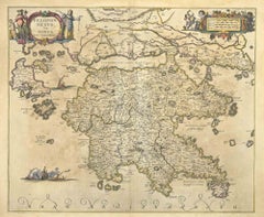
Southern Greece: A Large 17th Century Hand-colored Map By Sanson and Jaillot
By Nicholas Sanson d'Abbeville
Located in Alamo, CA
This large original hand-colored copperplate engraved map of southern Greece and the Pelopponese Peninsula entitled "La Moree Et Les Isles De Zante, Cefalonie, Ste. Marie, Cerigo & C...
Category
1690s Landscape Prints
Materials
Engraving

Peloponnesvs (Greece) - Etching by Johannes Janssonius - 1650s
By Johannes Janssonius
Located in Roma, IT
Peloponnesvs is an antique map realized in 1650 by Johannes Janssonius (1588-1664).
The Map is Hand-colored etching, with coeval watercoloring.
Good conditions with slight foxing.
...
Category
1650s Modern Figurative Prints
Materials
Etching
More Ways To Browse
Antique Compasses
Antique Hospital
17th Century Ottoman
Antique Hospital Furniture
17th Century Dutch Wood Frames
Antique Gold Compass
Compass Rose Gold
Silver Bowl Large
Down Couch
Used Lighter Art
Blue Edge Glass
Mahogany 1950s Furniture
Solid Mahogany Table
Dessert Glasses
Geometric Glass Table
Mid Century Pin
6x10 Rug
Studded Furniture