Items Similar to 1782 Map of the East Indies – India, Siam, Philippines, Java, Borneo, Ganges

Want more images or videos?
Request additional images or videos from the seller
1 of 10
1782 Map of the East Indies – India, Siam, Philippines, Java, Borneo, Ganges
$313
$391.2520% Off
£234.24
£292.8120% Off
€264
€33020% Off
CA$431.81
CA$539.7620% Off
A$480.19
A$600.2320% Off
CHF 252.20
CHF 315.2620% Off
MX$5,870.77
MX$7,338.4620% Off
NOK 3,142.71
NOK 3,928.3920% Off
SEK 2,962.73
SEK 3,703.4120% Off
DKK 2,009.70
DKK 2,512.1220% Off
About the Item
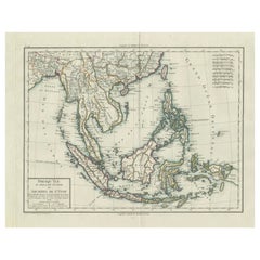
1782 Bayly Map of the East Indies – India, Siam, Philippines, Java, Borneo, Ganges
This finely engraved and vibrantly hand-colored map titled 'A New Map of the East Indies' was drawn by John Bayly and published in London by Harrison & Co. on June 1, 1782. The map spans the region from Persia and Afghanistan in the northwest to New Guinea and the western Pacific in the southeast, focusing on Southeast Asia and the Bay of Siam.
The map covers a broad and historically rich area, including India, Ceylon (Sri Lanka), Burma (Myanmar), Siam (Thailand), Malacca (Malaysia), Sumatra, Java, Borneo, the Philippines, and parts of China, including Canton. It includes important colonial and trade centers of the 18th century, such as Batavia (Jakarta), Goa, and Manilla. Notably, Singapore is not yet named, but Johor (spelled "Johr") is marked, reflecting the geopolitical landscape of the time.
An elegant inset in the upper right corner provides a detailed view of the Mouths of the Ganges, showing Calcutta and the river delta with an intricate depiction of river branches and settlements. The map is drawn on a Mercator projection and includes latitude and longitude markings with a scale at bottom.
This is an uncommon and desirable piece for collectors interested in 18th-century cartography, maritime trade history, or the colonial period in Asia. Bayly's map offers a valuable snapshot of European understanding of the East Indies during the late Enlightenment era.
The map features strong plate impressions, vivid original hand coloring, and finely engraved detail throughout. The condition is very good with light age toning, original fold lines, and only minimal margin wear. It is printed on laid paper, typical of the period.
Here are short tips for framing this 1782 Bayly map of the East Indies:
- Use acid-free mat and backing to protect the paper
- Choose a light cream or ivory mat to highlight the hand coloring
- A simple dark wood or black frame complements the antique style
- Consider float mounting to show the full plate and any original folds
- Use UV-protective glass to prevent fading
- Keep the map away from direct sunlight and humidity for preservation
Keywords:
East Indies map 1782, John Bayly, Harrison & Co., antique map of Asia, Ceylon, Siam, Batavia, Malacca, Ganges River map, Southeast Asia, Philippines, India, Java, Borneo, colonial trade, Mercator projection, 18th-century cartography, engraved map, British mapmaker, historical geography
- Dimensions:Height: 10.24 in (26 cm)Width: 13.59 in (34.5 cm)Depth: 0.01 in (0.2 mm)
- Materials and Techniques:Paper,Engraved
- Period:1780-1789
- Date of Manufacture:1782
- Condition:The map features strong plate impressions, vivid original hand coloring, and finely engraved detail throughout. The condition is very good with light age toning, original fold lines, and only minimal margin wear. It is printed on laid paper.
- Seller Location:Langweer, NL
- Reference Number:Seller: BGSH-0161stDibs: LU3054344557492
About the Seller
5.0
Recognized Seller
These prestigious sellers are industry leaders and represent the highest echelon for item quality and design.
Platinum Seller
Premium sellers with a 4.7+ rating and 24-hour response times
Established in 2009
1stDibs seller since 2017
2,609 sales on 1stDibs
Typical response time: <1 hour
- ShippingRetrieving quote...Shipping from: Langweer, Netherlands
- Return Policy
Authenticity Guarantee
In the unlikely event there’s an issue with an item’s authenticity, contact us within 1 year for a full refund. DetailsMoney-Back Guarantee
If your item is not as described, is damaged in transit, or does not arrive, contact us within 7 days for a full refund. Details24-Hour Cancellation
You have a 24-hour grace period in which to reconsider your purchase, with no questions asked.Vetted Professional Sellers
Our world-class sellers must adhere to strict standards for service and quality, maintaining the integrity of our listings.Price-Match Guarantee
If you find that a seller listed the same item for a lower price elsewhere, we’ll match it.Trusted Global Delivery
Our best-in-class carrier network provides specialized shipping options worldwide, including custom delivery.More From This Seller
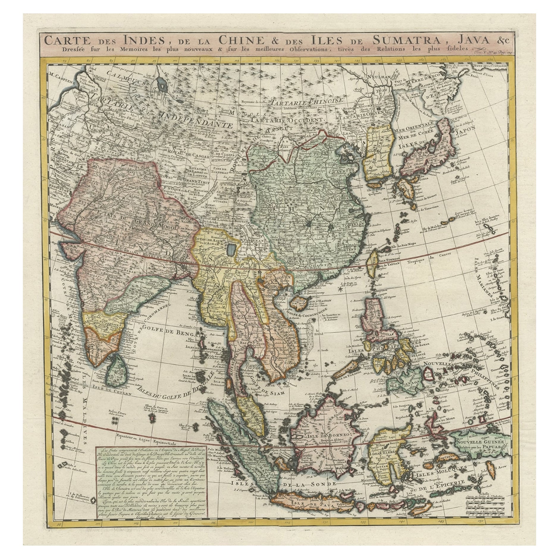
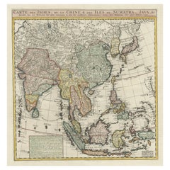
View AllDetailed Original Antique Map of India, Southeast Asia and the Far East, 1719
Located in Langweer, NL
Antique map titled 'Carte des Indes, de la Chine & des Iles de Sumatra, Java & c'.
Detailed map of India, Southeast Asia and the Far East, extending from Gujerat to the supposed "T...
Category
Antique 1710s Maps
Materials
Paper
$1,659 Sale Price
20% Off
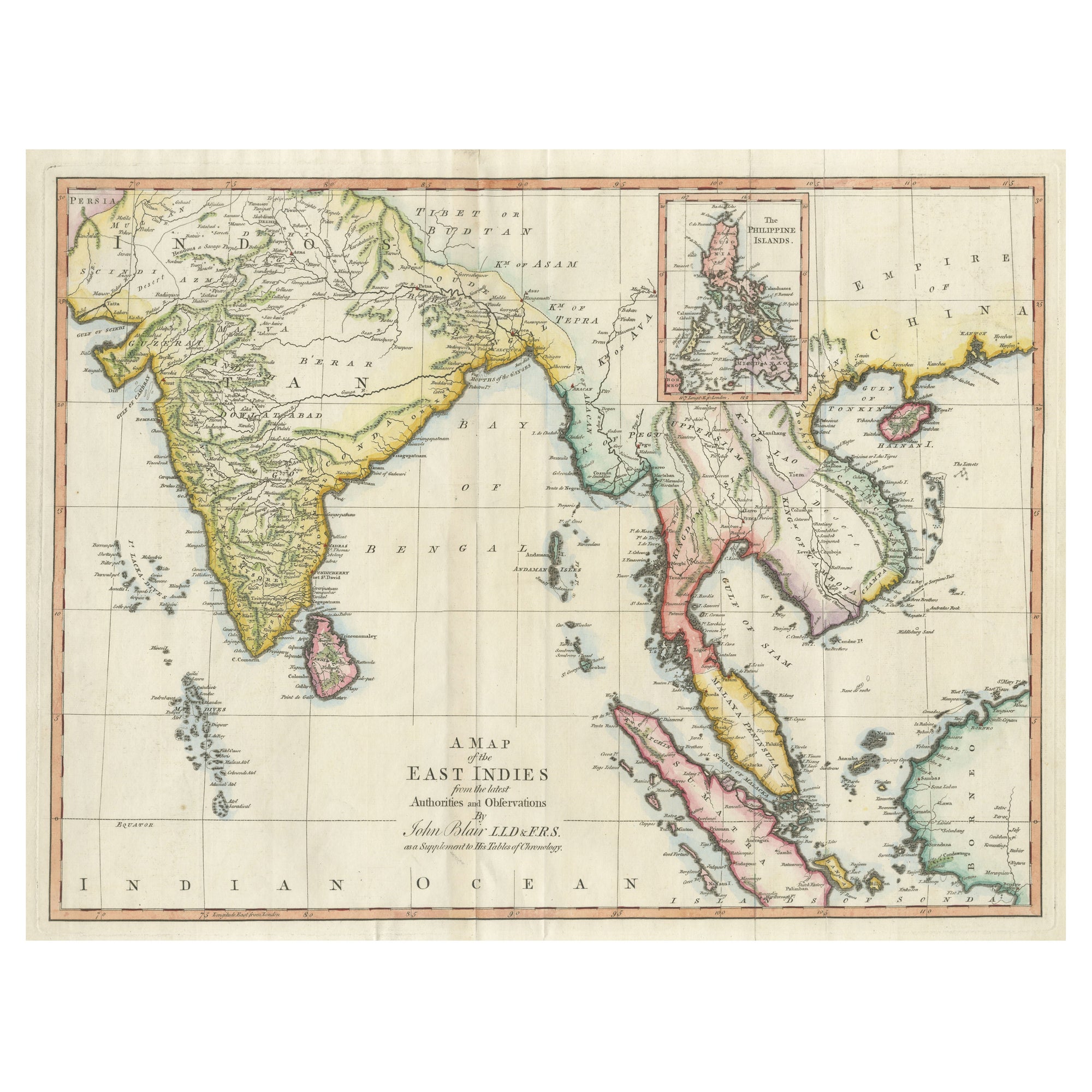
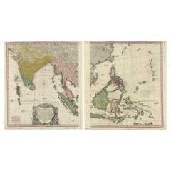
Large Antique Map of the East Indies, with Inset of the Philippines
Located in Langweer, NL
Antique map titled 'A Map of the East Indies (..)'. Large antique map of Southeast Asia, India, and part of China, extending to Tibet, the Maladives, Sumatra, part of Borneo, Hainan,...
Category
Antique Late 18th Century Maps
Materials
Paper

$464 Sale Price
20% Off
Large Antique Map of Asia including All of Southeast Asia, c.1792
Located in Langweer, NL
Antique map titled 'L' Asie Divisee en ses Empires, Royaumes, et Etats'. Attractive, large map of Asia including all of Southeast Asia. The cartography is archaic for the period with...
Category
Antique 18th Century Maps
Materials
Paper

$1,422 Sale Price
20% Off
Free Shipping
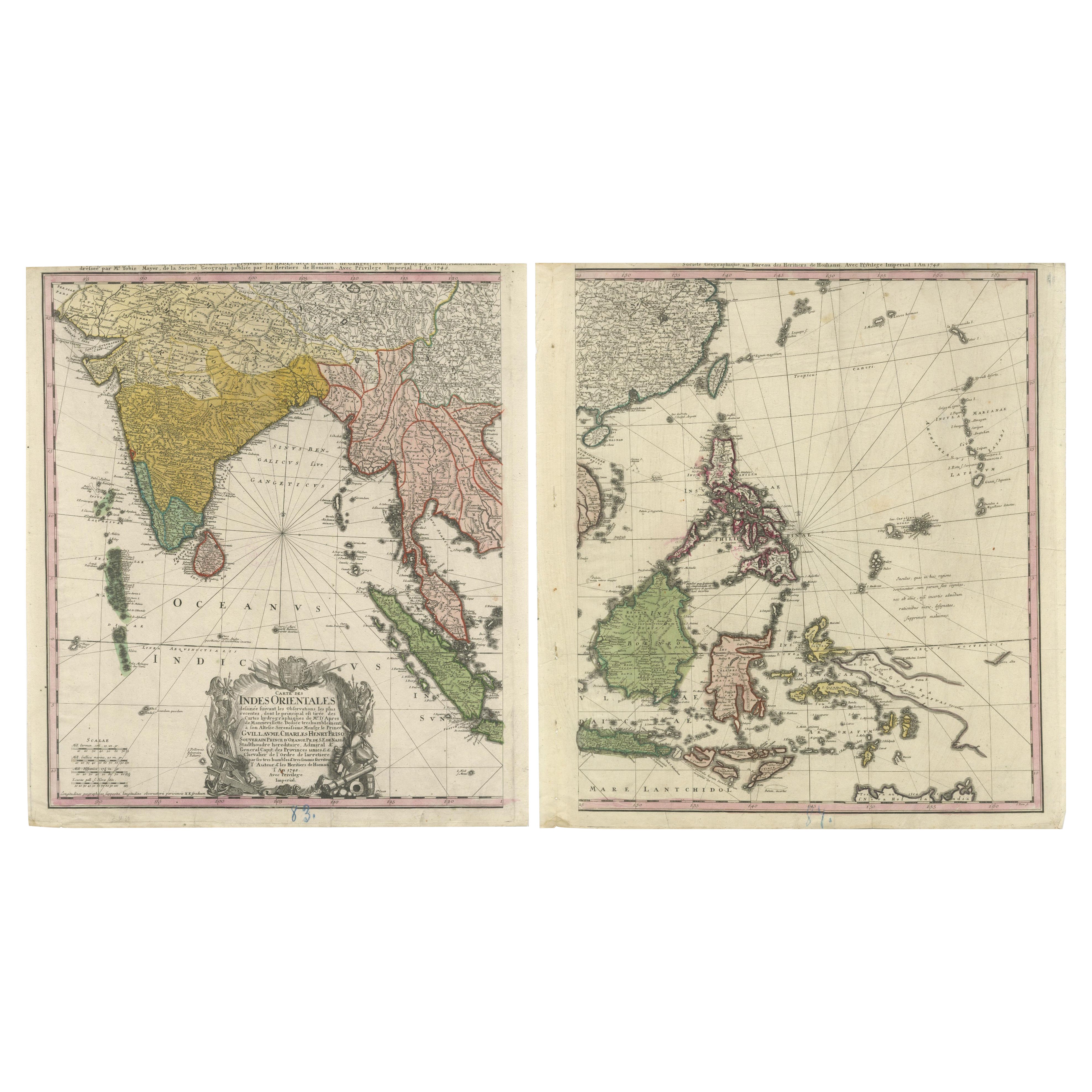
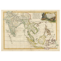
1748 Homann Heirs Double Map of the East Indies and Southeast Asia
Located in Langweer, NL
Title: 1774 Homann Heirs Double Map of the East Indies and Southeast Asia
Description:
This stunning 1774 double map by the Homann Heirs showcases the East Indies and Southeast ...
Category
Antique 1740s Maps
Materials
Paper
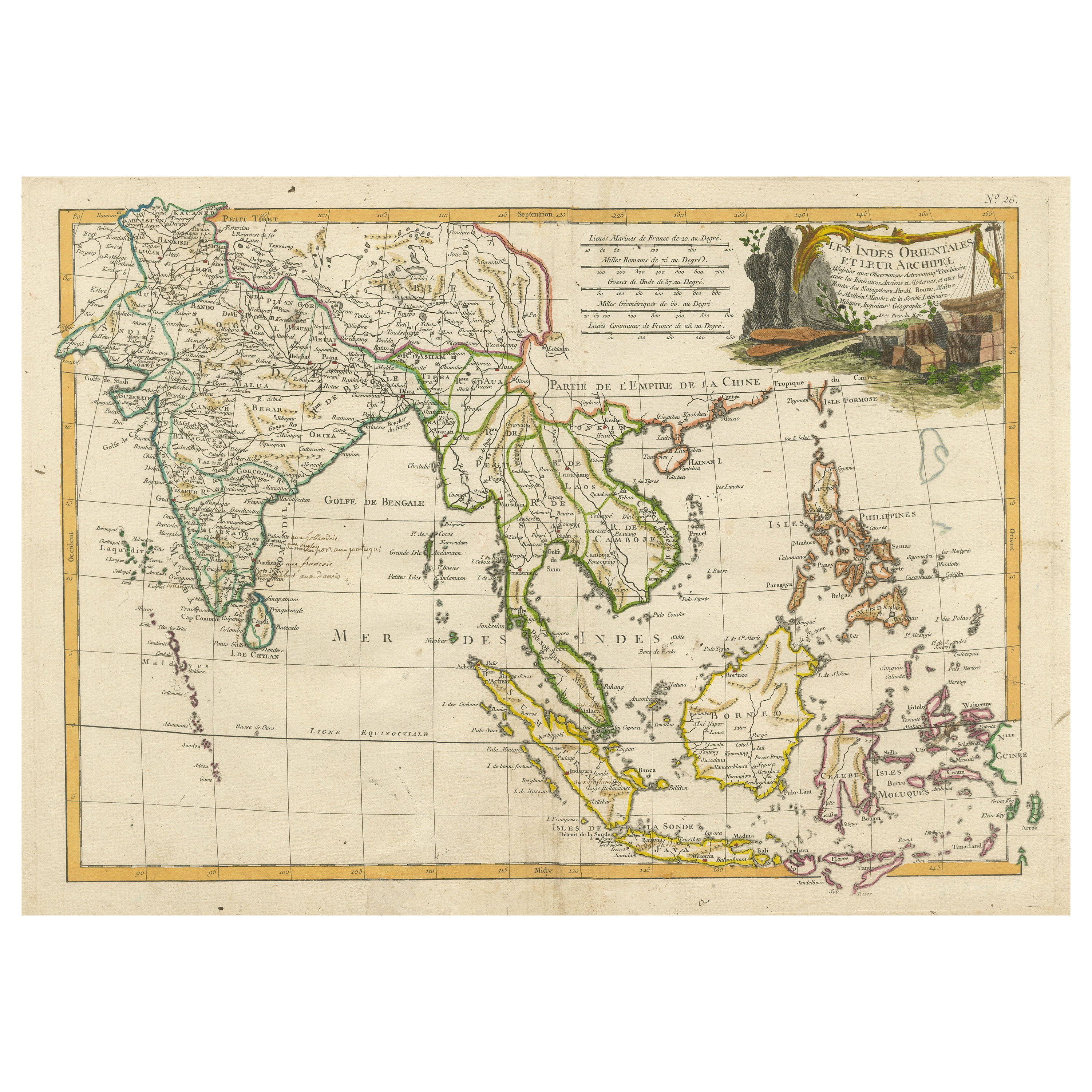
Antique Map of Southeast Asia with Decorative Allegorical Cartouche
Located in Langweer, NL
Antique map titled 'Les Indes Orientales et leur Archipel'. Old map of Southeast Asia, the Straits of Malaca, Philippines, Sumatra, Java, India etc., extending north to Canton and Ma...
Category
Antique Mid-18th Century Maps
Materials
Paper
$891 Sale Price
20% Off
Free Shipping
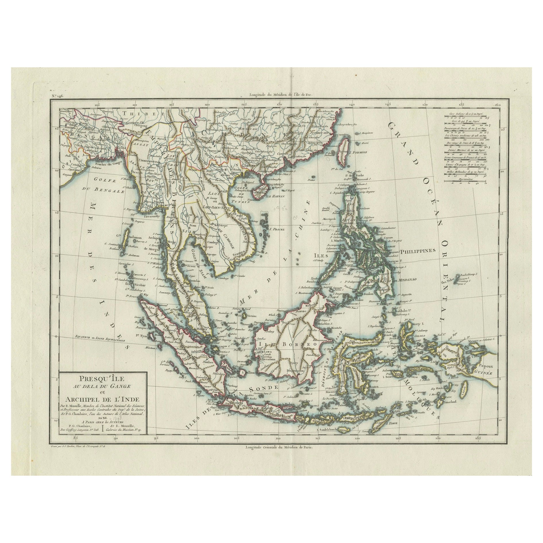
1797 Tardieu Map of Southeast Asia: The Malay Archipelago and Beyond
Located in Langweer, NL
An original historical map titled 'Presqu' Île Au Dela Du Gange et Archipel De L'Inde', created by Pierre Francois Tardieu and published in the "Atlas Universel" by Pierre Grégoire C...
Category
Antique 1790s Maps
Materials
Paper
$1,090 Sale Price
20% Off
Free Shipping
You May Also Like
Antique 1803 Italian Map of Asia Including China Indoneseia India
Located in Amsterdam, Noord Holland
Antique 1803 Italian Map of Asia Including China Indoneseia India
Very nice map of Asia. 1803.
Additional information:
Type: Map
Country of Manufacturing: Europe
Period: 19th centu...
Category
Antique 19th Century European Maps
Materials
Paper

$584 Sale Price
20% Off
Antique French Map of Asia Including China Indoneseia India, 1783
Located in Amsterdam, Noord Holland
Very nice map of Asia. 1783 Dedie au Roy.
Additional information:
Country of Manufacturing: Europe
Period: 18th century Qing (1661 - 1912)
Condition: Overall Condition B (Good Used)...
Category
Antique 18th Century European Maps
Materials
Paper

$648 Sale Price
20% Off
Map of the East Indies: An Original 18th Century Hand-colored Map by E. Bowen
Located in Alamo, CA
This is an original 18th century hand-colored map entitled "An Accurate Map of the East Indies Exhibiting the Course of the European Trade both on the Continent and Islands" by Emanu...
Category
Mid-18th Century Old Masters Landscape Prints
Materials
Engraving

Original Antique Map of South East Asia by Thomas Clerk, 1817
Located in St Annes, Lancashire
Great map of South East Asia
Copper-plate engraving
Drawn and engraved by Thomas Clerk, Edinburgh.
Published by Mackenzie And Dent, 1817
Unframed.
Category
Antique 1810s English Maps
Materials
Paper

Original Antique Map of India by Dower, circa 1835
Located in St Annes, Lancashire
Nice map of India
Drawn and engraved by J.Dower
Published by Orr & Smith. C.1835
Unframed.
Free shipping
Category
Antique 1830s English Maps
Materials
Paper

Large Original Vintage Map of S.E Asia, with a Vignette of Singapore
Located in St Annes, Lancashire
Great map of South East Asia
Original color. Good condition
Published by Alexander Gross
Unframed.
Category
Vintage 1920s English Maps
Materials
Paper

More Ways To Browse
Filipino Wood
Pacific Northwest Furniture
Antique Ivory Collectables
Colonial British India Furniture
Philippines Antique
Antique Glass Floats
Antique Canton Plates
Canton Plate
Antique Print Ceylon
Chinese Canton Plate
Colonial Sri Lankan
Singapore Antique
Borneo Wood
Antique Wood Furniture Philippines
Burmese Antique Print
British East Indies
Borneo Mat
Silver Bowl Large