Items Similar to 17th Century Map of Denmark by French Cartographer Sanson, Dated 1658


Want more images or videos?
Request additional images or videos from the seller
1 of 8
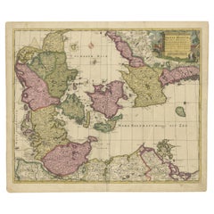
17th Century Map of Denmark by French Cartographer Sanson, Dated 1658
$1,750
£1,315.88
€1,521.56
CA$2,469.73
A$2,679.78
CHF 1,421.58
MX$32,907.55
NOK 17,580.28
SEK 16,648.50
DKK 11,357.83
About the Item
17th century map of Denmark by French cartographer Sanson.
Nicolas Sanson (20 December 1600-7 July 1667) was a French cartographer, termed by some the creator of French geography and has been called the "father of French cartography.
The engraved map is hand-colored and dated 1658.
The gilded frame is from circa 1900 and has minor losses to the gilding to the upper left corner.
- Creator:Nicolas Sanson (Artist)
- Dimensions:Height: 18.51 in (47 cm)Width: 23.23 in (59 cm)Depth: 0.4 in (1 cm)
- Materials and Techniques:
- Place of Origin:
- Period:
- Date of Manufacture:1658
- Condition:Wear consistent with age and use. Minor losses. Minor fading.
- Seller Location:Copenhagen, DK
- Reference Number:Seller: 323411stDibs: LU101368787783
About the Seller
4.9
Vetted Professional Seller
Every seller passes strict standards for authenticity and reliability
Established in 1949
1stDibs seller since 2013
140 sales on 1stDibs
- ShippingRetrieving quote...Shipping from: Copenhagen, Denmark
- Return Policy
Authenticity Guarantee
In the unlikely event there’s an issue with an item’s authenticity, contact us within 1 year for a full refund. DetailsMoney-Back Guarantee
If your item is not as described, is damaged in transit, or does not arrive, contact us within 7 days for a full refund. Details24-Hour Cancellation
You have a 24-hour grace period in which to reconsider your purchase, with no questions asked.Vetted Professional Sellers
Our world-class sellers must adhere to strict standards for service and quality, maintaining the integrity of our listings.Price-Match Guarantee
If you find that a seller listed the same item for a lower price elsewhere, we’ll match it.Trusted Global Delivery
Our best-in-class carrier network provides specialized shipping options worldwide, including custom delivery.More From This Seller
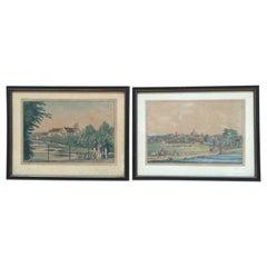
View AllFour 18th Century Engraved and Hand-Colored Maps by Weigel
By Christoph Weigel
Located in Copenhagen, K
Small collection of four engraved maps of Italy, Balkan and of Central Asia.
Two are of Italy, one Corsica and Northern Italy and the other of the Southern Italian boot...
Category
Antique 18th Century German Maps
Materials
Paper
Engravings of Landscape and Estates of Herlufsholm, Gavnø and Næstved
Located in Copenhagen, K
18th century engravings of landscape and Estates of Herlufsholm, Gavnø and Næstved.
Category
Antique 18th Century Danish Prints
Materials
Paper
19th Century Engravings of Landscape and Estate of Herlufsholm and Naestved
Located in Copenhagen, K
The two 19th century engravings of the town of Naestved and Estate of Herlufsholm are hand-colored and dated circa 1820s.
The engravings are made by Heinrich Gustav Ferdinand Holm, ...
Category
Antique Early 19th Century Danish Prints
Materials
Paper
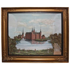
19th Century Diorama of Frederiksborg Castle in Denmark
Located in Copenhagen, K
Amazing Danish model representing a scene with three-dimensional figures of Frederiksborg castle and gardens. With miniature people and trees in the f...
Category
Antique Early 19th Century Danish Folk Art Paintings
Materials
Paint
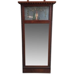
Danish 18th Century Empire Mirror
Located in Copenhagen, K
Elegant Empire mirror with hand-painted flowers and statue in the upper glass part.
Category
Antique 18th Century Danish Empire Wall Mirrors
Materials
Glass, Wood
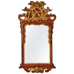
Danish 18th Century Gilded Freemason Guild Rococo Mirror
Located in Copenhagen, K
Fantastic Rococo Ealdorman mirror, with incredible gilded carvings of carpenters tools. Made for or by a ealdorman.
Category
Antique Late 18th Century Danish Rococo Wall Mirrors
Materials
Wood
$4,400 Sale Price
36% Off
You May Also Like
Map of Denmark Divided into Dioceses – G. & L. Valk, ca. 1690
Located in Langweer, NL
Map of Denmark Divided into Dioceses – G. & L. Valk, ca. 1700
Detailed antique map titled "Regnum Daniae, divisum in Dioeceses Arhusiam, Albergum, Viborgum, et Ripam," showing Denma...
Category
Antique Late 17th Century Maps
Materials
Paper

$526 Sale Price
20% Off
Antique Map of Denmark by F. de Wit, 1680
Located in Langweer, NL
Antique map titled 'Dania Regnum'. Large, attractive map of Denmark, Sleschwig-Holstein and southern Sweden. Good detail throughout. Embellished with a title cartouche with the Danis...
Category
Antique Late 17th Century Maps
Materials
Paper

$923 Sale Price
20% Off
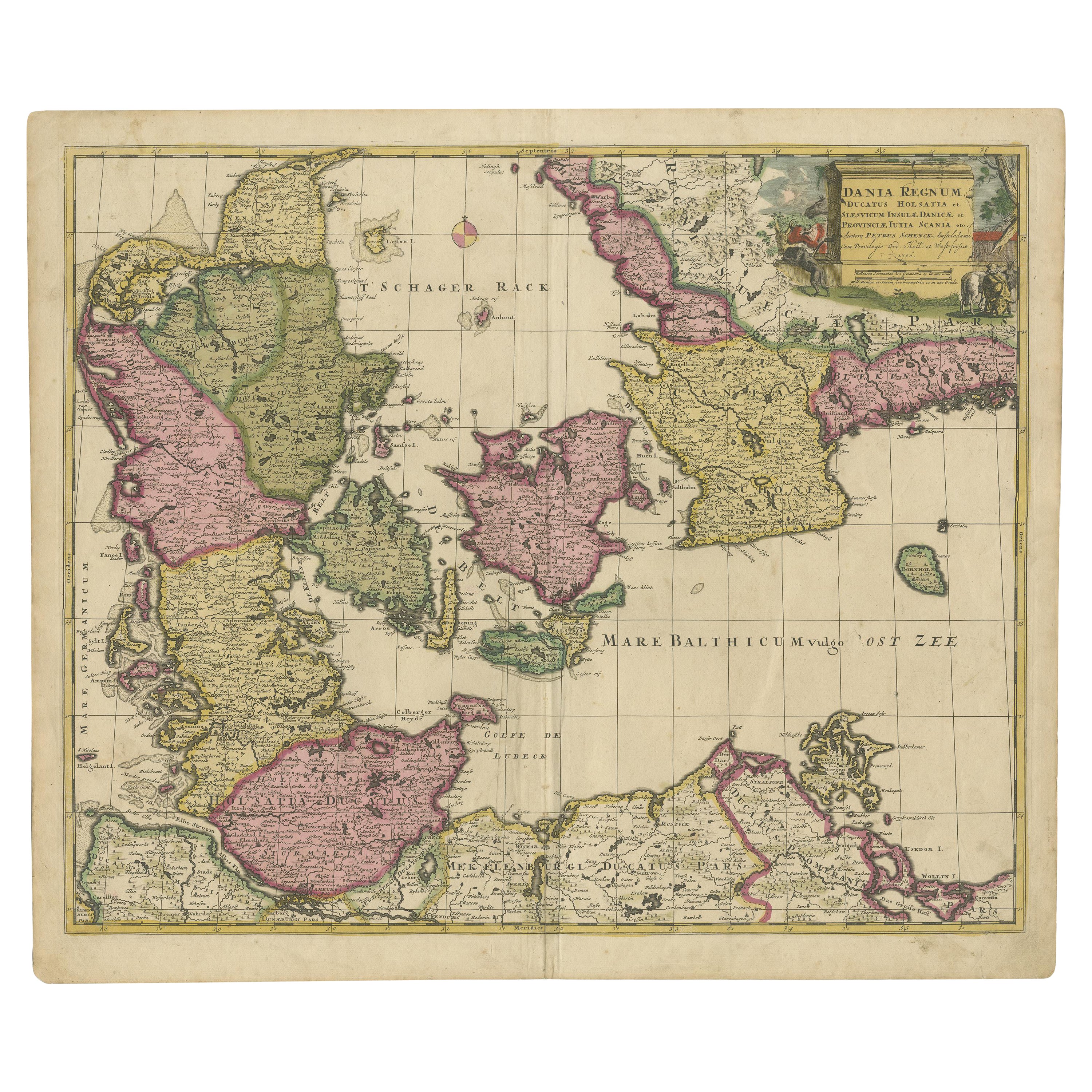
Early 18th Century Map of Denmark in Old Coloring, Published in 1706
Located in Langweer, NL
Denmark. Schenk (Petrus), Dania Regnum Ducatus Holsatia. et Slesvicum Insulae Danicae et Provinciae Jutia Scania etc. Amsterdam, 1706, engraved reticulated map on thick paper with co...
Category
Antique Early 1700s Maps
Materials
Paper
$680 Sale Price
20% Off
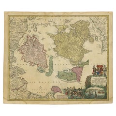
Antique Map of Denmark and Southern Sweden, c.1658
Located in Langweer, NL
Antique map titled 'Royaume de Danemarq.' Map centered on Sjaelland and covers all of Denmark and part of southern Sweden where a dramatic title cartouche obscures the interior. Sour...
Category
Antique 17th Century Maps
Materials
Paper

$258 Sale Price
20% Off
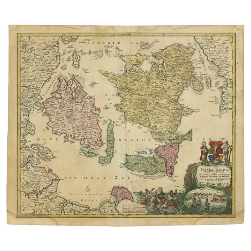
Antique Map of Denmark with Details of Fortresses, Cities, Towns Etc, c.1680
Located in Langweer, NL
Antique map of Denmark titled 'Insularum Danicarum ut Zee-Landiae, Fioniae, Langelandiae, Lalandiae Falstriae, Fembriae, Monae (..)'. This map depicts the main Danish Islands and a s...
Category
Antique 17th Century Maps
Materials
Paper

$717 Sale Price
20% Off
Free Shipping
Antique Map of the Islands of Denmark by Homann Heirs, 1720
Located in Langweer, NL
Antique map titled 'Insula Danicae in Mari Balthico sitae (..).' - Map of the Danish islands situated in the Baltic Sea by J. B. Homann, (after J. Hübner's map of the region ) with g...
Category
Antique 18th Century Maps
Materials
Paper
$333 Sale Price
20% Off
More Ways To Browse
Antique Russian Rugs
For Kids
Sterling Silver Flatware Set Service For 12
Tufted Bar
Pair Of French Antique Armchairs
1970s Brass Glass Coffee Table
Charles Rennie Mackintosh For Cassina
Glass Salt
Italian Modern Silver Vases
Vintage Resin Tables
Antique English Country Furniture
Blue Kilim Vintage
Contemporary Side Tables And Stools
Decorative Wall Plate
Mid Century Modern Corner Chair
Dining Tables With Brass Inlay
Oak Mid Century Armchair
Solid Wood Side Table Stool