Items Similar to 1808 C. Smith Map of Hindoostan – British India with Intricate Details
Want more images or videos?
Request additional images or videos from the seller
1 of 8
1808 C. Smith Map of Hindoostan – British India with Intricate Details
$373.03
$466.2920% Off
£276.16
£345.2020% Off
€312
€39020% Off
CA$516.18
CA$645.2320% Off
A$569.08
A$711.3520% Off
CHF 297.72
CHF 372.1620% Off
MX$6,981.56
MX$8,726.9520% Off
NOK 3,747.76
NOK 4,684.7020% Off
SEK 3,504.75
SEK 4,380.9420% Off
DKK 2,376.62
DKK 2,970.7820% Off
About the Item
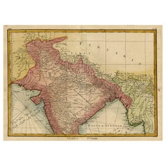
Title: 1808 C. Smith Map of Hindoostan – British India with Intricate Details
This map, titled "Hindoostan," was published by C. Smith, a prominent London map seller, on January 6, 1808, from No. 172 Strand. It provides a detailed view of the Indian subcontinent during the early 19th century, reflecting British colonial interest and expanding influence in the region.
The map features the vast territories of India, Pakistan, Bangladesh, Nepal, Bhutan, and Sri Lanka (Ceylon), including the Bay of Bengal and Arabian Sea, along with the Indian Ocean's coastal areas. Notable regions and provinces are highlighted in distinct colors, illustrating the various political boundaries of the time. The Himalayan range, the Indus, and the Ganges rivers are particularly well-represented, showcasing the critical geographical features of the subcontinent.
Important cities marked on the map include Calcutta, Madras, Bombay, and Delhi, reflecting key colonial centers of administration. The map also depicts parts of Persia (Iran) and Tibet in the northwest, showing the geopolitical reach of British cartography at the time.
The engraving is finely detailed, and hand-coloring remains vivid, despite some toning around the edges typical of antique maps of this period. The presence of an engraved grid helps with navigation and orientation, a valuable feature for maps of this era.
Collectors of early 19th-century cartography will appreciate the high quality of this map, as it represents an important period in British imperial history and the advancement of geographical knowledge.
Condition: The map appears to be in good condition, with visible aging signs such as mild toning and light wear to the margins. The engraved details remain sharp, and the hand-coloring is still clear, though slightly muted with age. The paper is intact, and no significant tears or repairs are visible. Any minor imperfections, such as slight foxing or creases, do not detract from the overall quality of the map.
This map is ideal for collectors interested in British colonial history or cartographic representation of India during the early 1800s.
- Dimensions:Height: 15.56 in (39.5 cm)Width: 12.21 in (31 cm)Depth: 0 in (0.02 mm)
- Materials and Techniques:Paper,Engraved
- Period:
- Date of Manufacture:1808
- Condition:Condition: good, given age. General age-related toning and/or occasional minor defects from handling. Please study scan carefully.
- Seller Location:Langweer, NL
- Reference Number:Seller: BG-13777-51stDibs: LU3054341785442
About the Seller
5.0
Recognized Seller
These prestigious sellers are industry leaders and represent the highest echelon for item quality and design.
Platinum Seller
Premium sellers with a 4.7+ rating and 24-hour response times
Established in 2009
1stDibs seller since 2017
2,613 sales on 1stDibs
Typical response time: <1 hour
- ShippingRetrieving quote...Shipping from: Langweer, Netherlands
- Return Policy
Authenticity Guarantee
In the unlikely event there’s an issue with an item’s authenticity, contact us within 1 year for a full refund. DetailsMoney-Back Guarantee
If your item is not as described, is damaged in transit, or does not arrive, contact us within 7 days for a full refund. Details24-Hour Cancellation
You have a 24-hour grace period in which to reconsider your purchase, with no questions asked.Vetted Professional Sellers
Our world-class sellers must adhere to strict standards for service and quality, maintaining the integrity of our listings.Price-Match Guarantee
If you find that a seller listed the same item for a lower price elsewhere, we’ll match it.Trusted Global Delivery
Our best-in-class carrier network provides specialized shipping options worldwide, including custom delivery.More From This Seller
View All1806 John Cary Map of Hindoostan – Detailed British Cartography of India
Located in Langweer, NL
Title: 1806 John Cary Map of Hindoostan – Detailed British Cartography of India
This highly detailed map, titled "A New Map of Hindoostan from the Latest Authorities," was engraved ...
Category
Antique Early 1800s Maps
Materials
Paper
$516 Sale Price
20% Off
Antique Map of Hindustan, or India
Located in Langweer, NL
Antique map titled 'Hindoostan, or India'. Original antique map of India (Hindustan) and Sri Lanka (Ceylon). Engraved by Russell. Published by Nuttall, Fisher & Co, 1814.
Category
Antique Early 19th Century Maps
Materials
Paper

$277 Sale Price
20% Off
1816 Large Southern Hindostan Map by J. Thomson – New General Atlas
Located in Langweer, NL
Title: 1816 Southern Hindostan Map by J. Thomson – New General Atlas
This map, titled "Southern Hindostan," was published in 1816 as part of J. Thomson’s *New General Atlas*. The ma...
Category
Antique 1810s Maps
Materials
Paper
$506 Sale Price
20% Off
Original and Colourful Map of Northern India with Surrounding Regions, 1783
Located in Langweer, NL
Antique map titled 'Indes'. A map of Northern India with surrounding regions. From Lattre's 'Atlas moderne ou collection de cartes sur toutes les parties du globe terrestre...
Category
Antique 1780s Maps
Materials
Paper
$545 Sale Price
20% Off
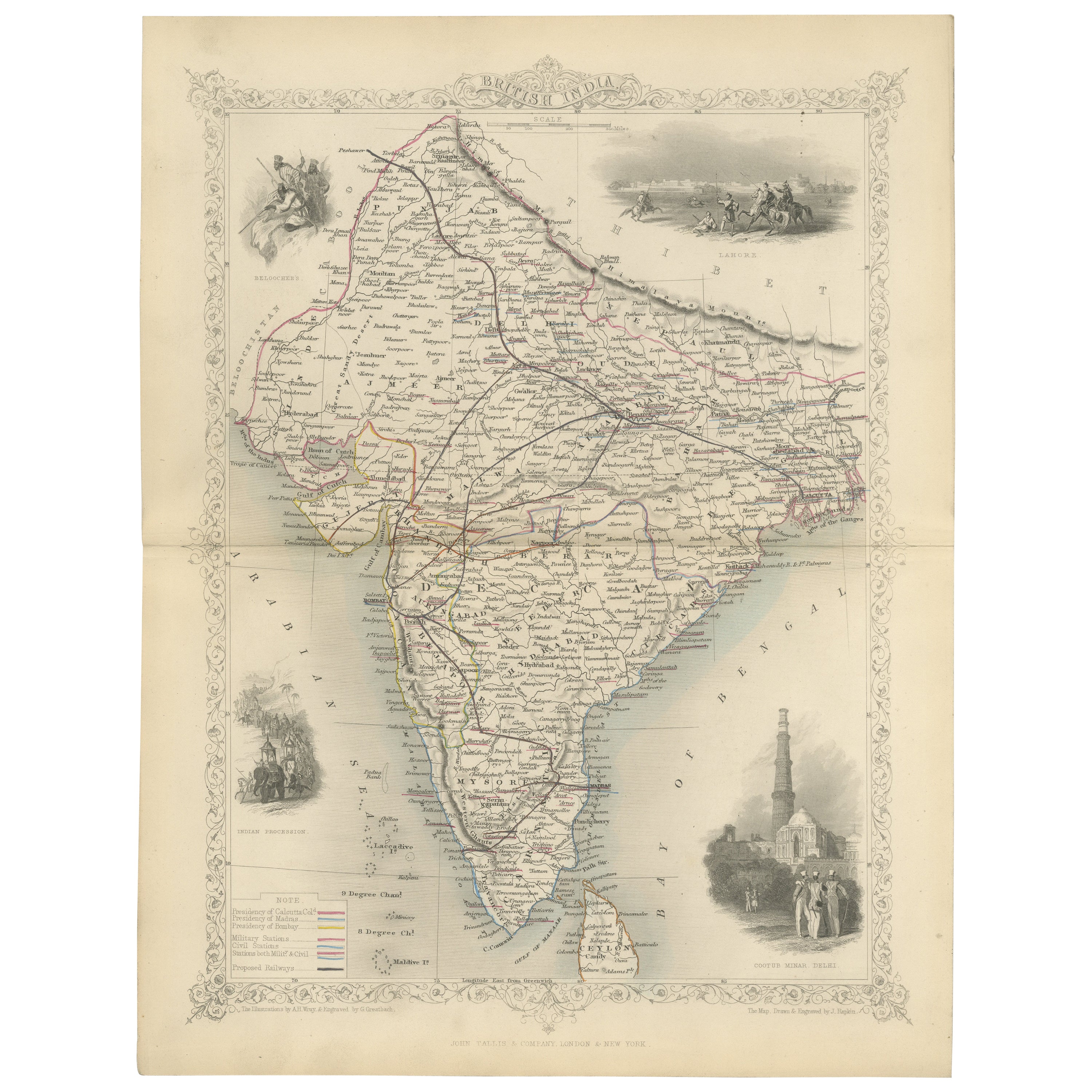
Mid-19th Century Decorative Map of India with Cultural and Natural Vignettes
Located in Langweer, NL
The Tallis maps, including the one of India, are known for their detailed and ornamental style. They were produced during the mid-19th century, a time when cartographic publishing became as much an art form as a means of geographic representation.
John Tallis & Company, founded by John Tallis, was known for creating maps with elaborate borders and vignettes surrounding the map itself. These maps often included illustrations that depicted scenes representative of the region's culture, significant local wildlife, architectural landmarks, and portraits of indigenous peoples...
Category
Antique 1850s Maps
Materials
Paper

$296 Sale Price
20% Off
Detailed Antique Map of the Region of Malwa in India, 1833
Located in Langweer, NL
Antique map titled 'India VI'. Old steel engraved map of the region of Malwa showing great detail.
Artists and Engravers: Engraved by J. & C. Walker. Published under the superint...
Category
Antique 19th Century Maps
Materials
Paper
$277 Sale Price
20% Off
You May Also Like
Original Antique Map of India by Dower, circa 1835
Located in St Annes, Lancashire
Nice map of India
Drawn and engraved by J.Dower
Published by Orr & Smith. C.1835
Unframed.
Free shipping
Category
Antique 1830s English Maps
Materials
Paper

Large Original Vintage Map of India, circa 1920
Located in St Annes, Lancashire
Great map of India
Original color.
Good condition / repair to some minor damage just above Sri Lanka. Shown in the last image.
Published by Alexander Gross
Unframed.
Category
Vintage 1920s English Maps
Materials
Paper

India (Southern Sheet), English antique map by Alexander Keith Johnston, 1901
Located in Melbourne, Victoria
'India (Southern Sheet)', antique lithographic map by Keith Johnston.
Inset maps of 'Bombay Island & Town', 'Madras & Environs', and 'South-Eastern Provinces of India'.
Central vertical fold as issued.
495mm by 625mm (sheet)
Alexander Keith...
Category
Early 20th Century Victorian More Prints
Materials
Lithograph

Antique 1803 Italian Map of Asia Including China Indoneseia India
Located in Amsterdam, Noord Holland
Antique 1803 Italian Map of Asia Including China Indoneseia India
Very nice map of Asia. 1803.
Additional information:
Type: Map
Country of Manufacturing: Europe
Period: 19th centu...
Category
Antique 19th Century European Maps
Materials
Paper

$584 Sale Price
20% Off
Map Of India - Original Lithograph - 19th Century
Located in Roma, IT
Map of India is an original lithograph artwork realized by an Anonymous engraver of the 19th Century.
Printed in the series of "France Pittoresque".
Titled "France Pittoresque".
...
Category
19th Century Modern Figurative Prints
Materials
Lithograph

Antique French Map of Asia Including China Indoneseia India, 1783
Located in Amsterdam, Noord Holland
Very nice map of Asia. 1783 Dedie au Roy.
Additional information:
Country of Manufacturing: Europe
Period: 18th century Qing (1661 - 1912)
Condition: Overall Condition B (Good Used)...
Category
Antique 18th Century European Maps
Materials
Paper

$648 Sale Price
20% Off
More Ways To Browse
British India
Madras India
Pedestal Mahogany Dining Table
Round Table Base
Metal Coffee Table 1970s
Italian Lacquer Dining Room Sets
Paisley Rugs and Carpets
Vintage Scandinavian Armchairs
1970 Italian Armchair
Antique Cow
Chrome Glass Coffee Tables
Environment Furniture
China Silk Rug
Early English Silver
Antique Walnut Bar
Ceramic 1960s Italy
Italian Carved Dining Set
Antique Silver Basket