Items Similar to 1884 Antique Map of Switzerland – Canton Divisions, Victorian Wall Art


Video Loading
Want more images or videos?
Request additional images or videos from the seller
1 of 12
1884 Antique Map of Switzerland – Canton Divisions, Victorian Wall Art
$380.95
£283.15
€320
CA$525.99
A$583.29
CHF 306.47
MX$7,126.78
NOK 3,834.41
SEK 3,599.25
DKK 2,436.64
About the Item
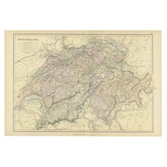
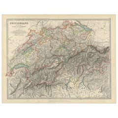
Antique Map of Switzerland with Cantons – Black’s Atlas, 1884
This beautifully engraved and hand-colored map of Switzerland was published in the New and Revised Edition of Black’s General Atlas of the World, Edinburgh, 1884. It presents Switzerland divided into its cantons, each distinguished with a separate pastel color wash, offering both political and topographical clarity.
The map highlights the country’s rugged alpine landscape, with mountain ranges, rivers, and lakes finely detailed. Major natural landmarks such as the Alps, Lake Geneva, Lake Constance, and Lake Lucerne are clearly marked. Cities including Zurich, Geneva, Bern, Basel, and Lausanne are prominently labeled, along with a wide network of towns, villages, and transportation routes.
Switzerland’s political divisions are carefully outlined, reflecting the cantonal system that defines the nation’s unique federal structure. The engraving captures both the natural barriers and the human settlements that shaped Swiss identity in the 19th century. The detail provided also illustrates the country’s importance as a crossroads of Europe, bordered by France, Germany, Austria, and Italy.
This map represents Switzerland at a time of modernization, when railways and trade routes strengthened its position as both a neutral state and a cultural meeting point of Europe. It stands as a significant historical artifact and an attractive decorative piece.
Condition report:
Good condition. Original hand coloring is fresh and clear. Margins with minor toning and faint spotting consistent with age. One small tear in upper left corner.
Framing tips:
An archival mat in light cream or ivory enhances the pastel canton colors. A walnut or black frame provides balance and depth, while a gilt frame emphasizes its Victorian elegance. UV-protective glass is recommended to preserve the original hand coloring.
Technique: Engraving with original hand coloring
Maker: Black’s General Atlas, Edinburgh, 1884
- Dimensions:Height: 12.45 in (31.6 cm)Width: 17.84 in (45.3 cm)Depth: 0.01 in (0.2 mm)
- Materials and Techniques:
- Place of Origin:
- Period:
- Date of Manufacture:1884
- Condition:Good condition. Original hand coloring is fresh and clear. Margins with minor toning and faint spotting consistent with age. One small tear in upper left corner.
- Seller Location:Langweer, NL
- Reference Number:Seller: BG-13601-3-101stDibs: LU3054346514912
About the Seller
5.0
Recognized Seller
These prestigious sellers are industry leaders and represent the highest echelon for item quality and design.
Platinum Seller
Premium sellers with a 4.7+ rating and 24-hour response times
Established in 2009
1stDibs seller since 2017
2,609 sales on 1stDibs
Typical response time: <1 hour
- ShippingRetrieving quote...Shipping from: Langweer, Netherlands
- Return Policy
Authenticity Guarantee
In the unlikely event there’s an issue with an item’s authenticity, contact us within 1 year for a full refund. DetailsMoney-Back Guarantee
If your item is not as described, is damaged in transit, or does not arrive, contact us within 7 days for a full refund. Details24-Hour Cancellation
You have a 24-hour grace period in which to reconsider your purchase, with no questions asked.Vetted Professional Sellers
Our world-class sellers must adhere to strict standards for service and quality, maintaining the integrity of our listings.Price-Match Guarantee
If you find that a seller listed the same item for a lower price elsewhere, we’ll match it.Trusted Global Delivery
Our best-in-class carrier network provides specialized shipping options worldwide, including custom delivery.More From This Seller
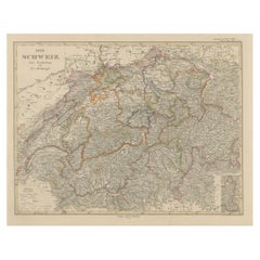
View AllOriginal Antique Map of Switzerland, 1882
Located in Langweer, NL
Embark on a historical journey with an original Antique Map of Switzerland from the renowned 'Comprehensive Atlas and Geography of the World...
Category
Antique 1880s Maps
Materials
Paper
$219 Sale Price
20% Off
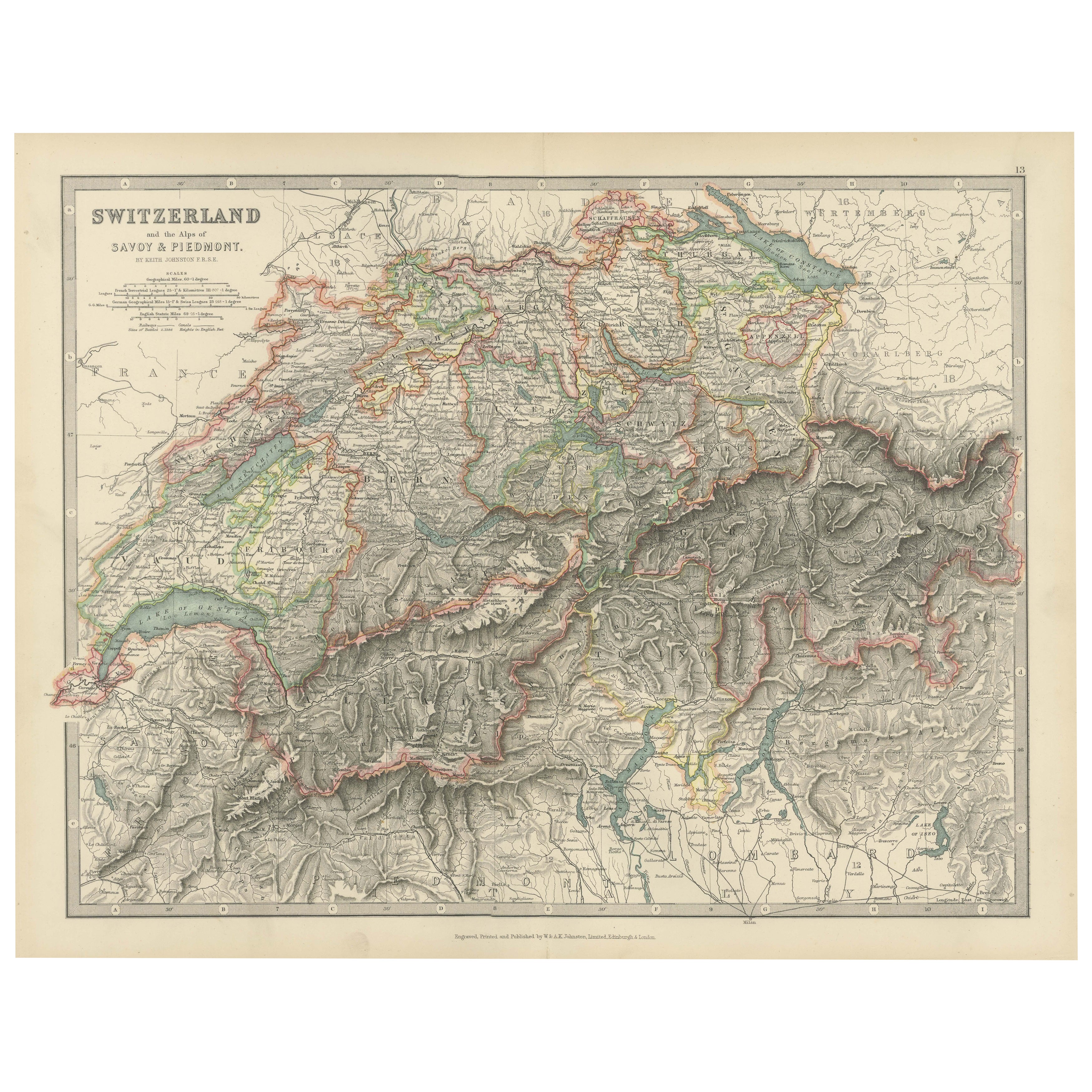
Antique Map of Switzerland by Johnston, 1882
Located in Langweer, NL
Antique map titled 'Switzerland and the Alps of Savoy and Piedmont'. Old map of Switzerland and the Alps of Savoy and Piedmont. This map originates from 'The Royal Atlas of Modern Ge...
Category
Antique 19th Century Maps
Materials
Paper

$123 Sale Price
20% Off
Antique Map of Switzerland and the Alps of Savoy & Piedmont, 1903 Edition
Located in Langweer, NL
Title: Antique Map of Switzerland and the Alps of Savoy & Piedmont, 1903, with Intricate Topographical Detail
Description:
This beautifully engraved antique map, titled "Switzerland...
Category
Early 20th Century Maps
Materials
Paper
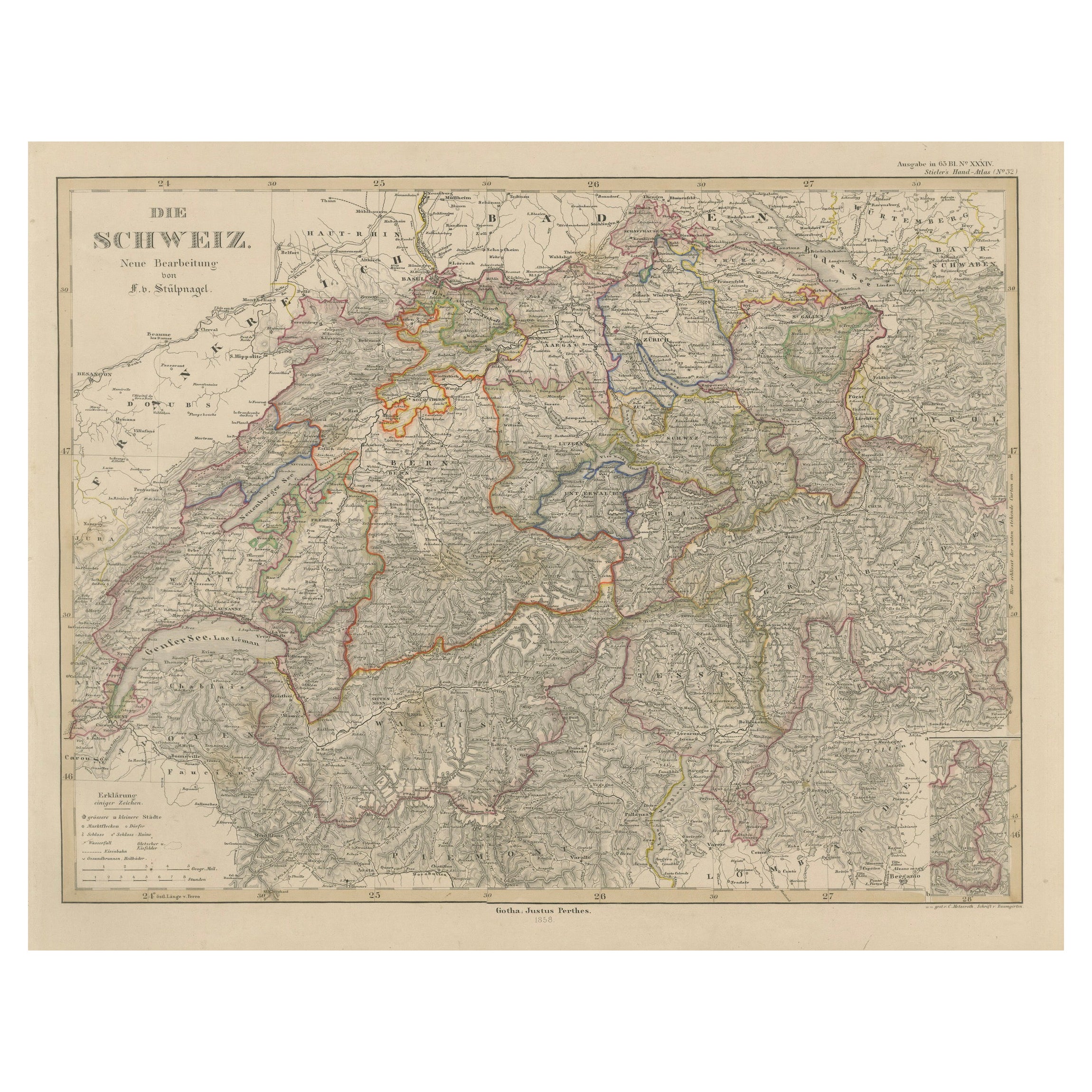
1856 Engraved Map of Switzerland with Cantonal Borders by Stülpnagel
Located in Langweer, NL
1856 Engraved Map of Switzerland with Cantonal Borders by Stülpnagel
This finely detailed antique map of Switzerland, titled "Die Schweiz," was published in 1856 by the renowned Ger...
Category
Antique Mid-19th Century German Maps
Materials
Paper
Antique Map of Switzerland by A & C. Black, 1870
Located in Langweer, NL
Antique map titled 'Switzerland'. Original antique map of Switzerland. This map originates from ‘Black's General Atlas of The World’. Published by A & C. Black, 1870.
Category
Antique Late 19th Century English Maps
Materials
Paper

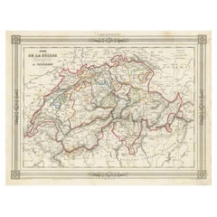
Swiss Splendor: Antique Map of Switzerland and Its Cantons, 1852
Located in Langweer, NL
The antique map titled 'Carte de la Suisse' is an attractive map of Switzerland. Here are the key details and features of the map:
1. **Geographic Coverage**:
- The map provides comprehensive coverage of Switzerland, depicting the entire country.
- It showcases the division of Switzerland by Cantons, including regions from Vaud to Grisons.
- Additionally, the map includes parts of adjacent countries, such as France, Germany, and Italy, providing context for Switzerland's geographical location.
2. **Cartographic Details**:
- The map offers detailed cartographic information, including the delineation of geographic features, rivers, mountains, and the names of Cantons and towns.
- It presents a clear and informative representation of Switzerland's topography.
3. **Origin**:
- This map originates from Maison Basset's 1852 edition of 'Atlas Illustre Destine a l'enseignement de la Geographie elementaire,' indicating its use for educational purposes, particularly in the teaching of geography.
4. **Educational Significance**:
- As part of an educational atlas, the map likely played a role in instructing students about the geography of Switzerland and its political subdivisions.
- It may have been employed as a visual aid to enhance students' understanding of Switzerland's Cantonal divisions.
5. **Aesthetic Appeal**:
- The map is described as attractive, suggesting that it possesses not only educational value but also visual appeal.
- Maps of this era often featured decorative elements that added to their aesthetic charm.
6. **Historical and Geopolitical Significance**:
- Switzerland's unique position in Europe, as a country surrounded...
Category
Antique Mid-19th Century Maps
Materials
Paper
$133 Sale Price
20% Off
You May Also Like
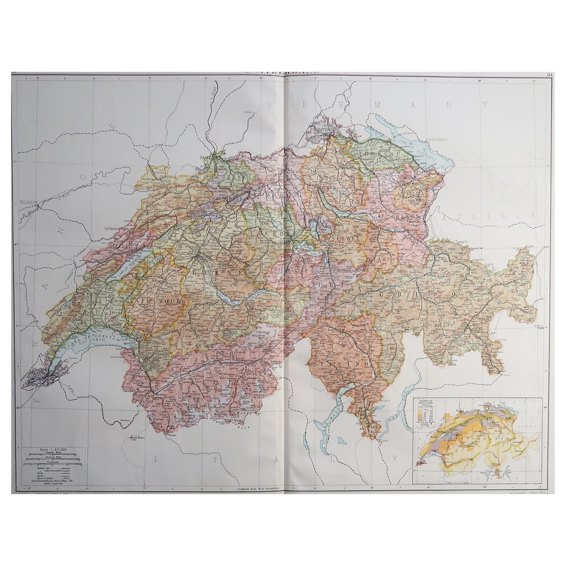
Large Original Vintage Map of Switzerland, circa 1920
Located in St Annes, Lancashire
Great map of Switzerland
Original color.
Good condition
Published by Alexander Gross
Unframed.
Category
Vintage 1920s English Maps
Materials
Paper
German Empire, Southwestern Part. Century Atlas antique vintage map
Located in Melbourne, Victoria
'The Century Atlas. German Empire, Southwestern Part'
Original antique map, 1903.
Central fold as issued. Map name and number printed on the reverse co...
Category
Early 20th Century Victorian More Prints
Materials
Lithograph

Austria-Hungary, Western Part. Century Atlas antique vintage map
Located in Melbourne, Victoria
'The Century Atlas. Austria-Hungary, Western Part'
Original antique map, 1903.
Central fold as issued. Map name and number printed on the reverse corners.
Sheet 40cm by 29.5cm.
Category
Early 20th Century Victorian More Prints
Materials
Lithograph

German Empire, Northern Part. Century Atlas antique vintage map
Located in Melbourne, Victoria
'The Century Atlas. German Empire, Northern Part.'
Original antique map, 1903.
Central fold as issued. Map name and number printed on the reverse corne...
Category
Early 20th Century Victorian More Prints
Materials
Lithograph

Original Antique Map of Switzerland, Engraved By Barlow, Dated 1807
Located in St Annes, Lancashire
Great map of Switzerland
Copper-plate engraving by Barlow
Published by Brightly & Kinnersly, Bungay, Suffolk.
Dated 1807
Unframed.
Category
Antique Early 1800s English Maps
Materials
Paper

Circa 1950 original illustrated map "Carte des Montagnes Suisses"
Located in PARIS, FR
The circa 1950 original illustrated map "Carte des Montagnes Suisses" by L. Koller is a beautifully crafted representation of Switzerland's mountainous regions, combining geographica...
Category
1950s Prints and Multiples
Materials
Lithograph, Paper, Linen
