1 of 20
1900s Stielers Hand Atlas 100 Maps
$584List Price
About the Item
- Dimensions:Height: 17.5 in (44.45 cm)Width: 12 in (30.48 cm)Depth: 3 in (7.62 cm)
- Style:Victorian (Of the Period)
- Materials and Techniques:
- Place of Origin:
- Period:
- Date of Manufacture:circa 1900
- Condition:Wear consistent with age and use. Box made to look like a book, and has tears, spots and fading, maps are in very good condition.
- Seller Location:Seguin, TX
- Reference Number:1stDibs: LU7228234753982
Authenticity Guarantee
In the unlikely event there’s an issue with an item’s authenticity, contact us within 1 year for a full refund. DetailsMoney-Back Guarantee
If your item is not as described, is damaged in transit, or does not arrive, contact us within 7 days for a full refund. Details24-Hour Cancellation
You have a 24-hour grace period in which to reconsider your purchase, with no questions asked.Vetted Professional Sellers
Our world-class sellers must adhere to strict standards for service and quality, maintaining the integrity of our listings.Price-Match Guarantee
If you find that a seller listed the same item for a lower price elsewhere, we’ll match it.Trusted Global Delivery
Our best-in-class carrier network provides specialized shipping options worldwide, including custom delivery.You May Also Like
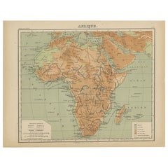
Colorfull Antique Map of Africa with Algeria Inset – Stieler Atlas 1858
Located in Langweer, NL
Antique Map of Africa with Algeria Inset – Stieler Atlas 1858
This antique map of Africa, engraved by F. von Stülpnagel and published by Justus Perthes in 1858, is a finely detailed...
Category
Antique Mid-19th Century German Maps
Materials
Paper
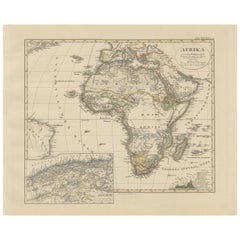
$455
H 14.77 in W 17.88 in D 0.01 in
Antique Map of West and Central Africa – Stieler Atlas, Justus Perthes 1857
Located in Langweer, NL
Antique Map of West and Central Africa – Stieler Atlas, Justus Perthes 1857
This finely engraved map titled "Mittel- und Nord-Africa. Westl. Theil." was published in 1857 by Justus ...
Category
Antique Mid-19th Century German Maps
Materials
Paper
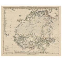
$407
H 14.77 in W 17.88 in D 0.01 in
Antique Map of Russia and Surroundings by Stieler, 1874
Located in Langweer, NL
Antique map titled 'Nord- & Mittal-Asien, Ubersicht des Russischen Reiches.' A map of Russia in scale 1:20.000.000. The depicted area spans from Iran and Sweden in the left edge of t...
Category
Antique 19th Century Maps
Materials
Paper

$67 Sale Price
20% Off
H 14.97 in W 19.1 in D 0 in
Antique Map of South East Australia by Stieler, c.1848
By Thomas Kitchin
Located in Langweer, NL
Antique map Australia titled 'Süd-Ost Australien'. Detailed map of South East Australia. Orginates from 'Stieler's Hand Atlas', published in Germ...
Category
Antique 19th Century Maps
Materials
Paper
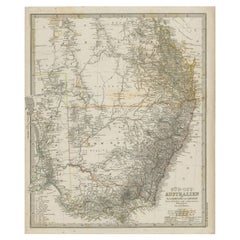
$57 Sale Price
20% Off
H 17.13 in W 14.38 in D 0 in
1880 Map of the Caribbean and Central America by Adolf Stieler
Located in Langweer, NL
This is a detailed map titled "West-Indien und Central-Amerika," created by Adolf Stieler and published in Gotha in 1880. The map covers the Caribbean islands and the Central America...
Category
Antique 1880s Maps
Materials
Paper
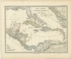
$278 Sale Price
20% Off
H 14.97 in W 18.51 in D 0 in
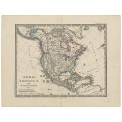
Antique Map of North America and the West Indies by Stieler, circa 1865
Located in Langweer, NL
Antique map titled 'Nord-America und West-Indien'. Old map of North America and the West Indies. This map originates from Stieler's 'Schul-Atlas'.
Category
Antique Mid-19th Century Maps
Materials
Paper
$115 Sale Price
20% Off
H 9.45 in W 12.21 in D 0.02 in
Map of Scandinavia – Antique Atlas Map by A. Levasseur, France, 1875
Located in Langweer, NL
Map of Scandinavia – Antique Atlas Map by A. Levasseur, France, 1875
This elegant 19th-century map titled Carte des Royaumes de Suède, de Norvège et de Danem...
Category
Antique Late 19th Century French Maps
Materials
Paper

$389 Sale Price
35% Off
H 24.02 in W 18.71 in D 0.02 in
Relief Atlas Map of Africa by Hachette – Antique c.1883 French Map
Located in Langweer, NL
Antique Map of Africa – Relief Atlas Map by Hachette, circa 1880
Description:
This is an attractive antique map titled “Afrique,” published by Hachette...
Category
Antique Late 19th Century Maps
Materials
Paper
$467
H 10.12 in W 12.84 in D 0.01 in
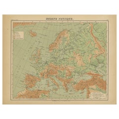
Relief Atlas Map of Europe by Hachette – Antique French Map c.1883
Located in Langweer, NL
Antique Map of Europe – Physical Relief Map by Hachette, circa 1883
Description:
This antique map titled “Europe Physique” was published by Hachette in Paris around 1883 and origina...
Category
Antique Late 19th Century French Maps
Materials
Paper
$467
H 10.12 in W 12.84 in D 0.01 in
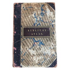
Antique Biblical Atlas with 17 Hand-Colored Maps, Religious Tract Society c.1850
Located in Langweer, NL
Antique Biblical Atlas with 17 Hand-Colored Maps, Religious Tract Society c.1850
This rare Biblical Atlas was published in London by the Religious Tract Society, founded in 1799, an...
Category
Antique Mid-19th Century English Maps
Materials
Paper
$1,186
H 10.01 in W 6.7 in D 0.44 in
Recently Viewed
View AllMore Ways To Browse
Antique Linen Box
Vintage Long Island Map
Vintage World Map Desk
Vintage World Map Mirror
Antique Furniture Toledo Ohio
Antique Maps Washington Dc
Blaeu World Map
Cape Cod Map
F Colton
Irish Antiques 16th Century
Ithaca Antique Map
Leonard Jones
Russia Globe
Salt Lake City Used Furniture
World Map Copper
Luxury Modern Carpet
French Directoire Furniture
French Earthenware