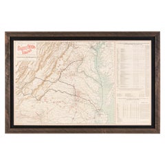
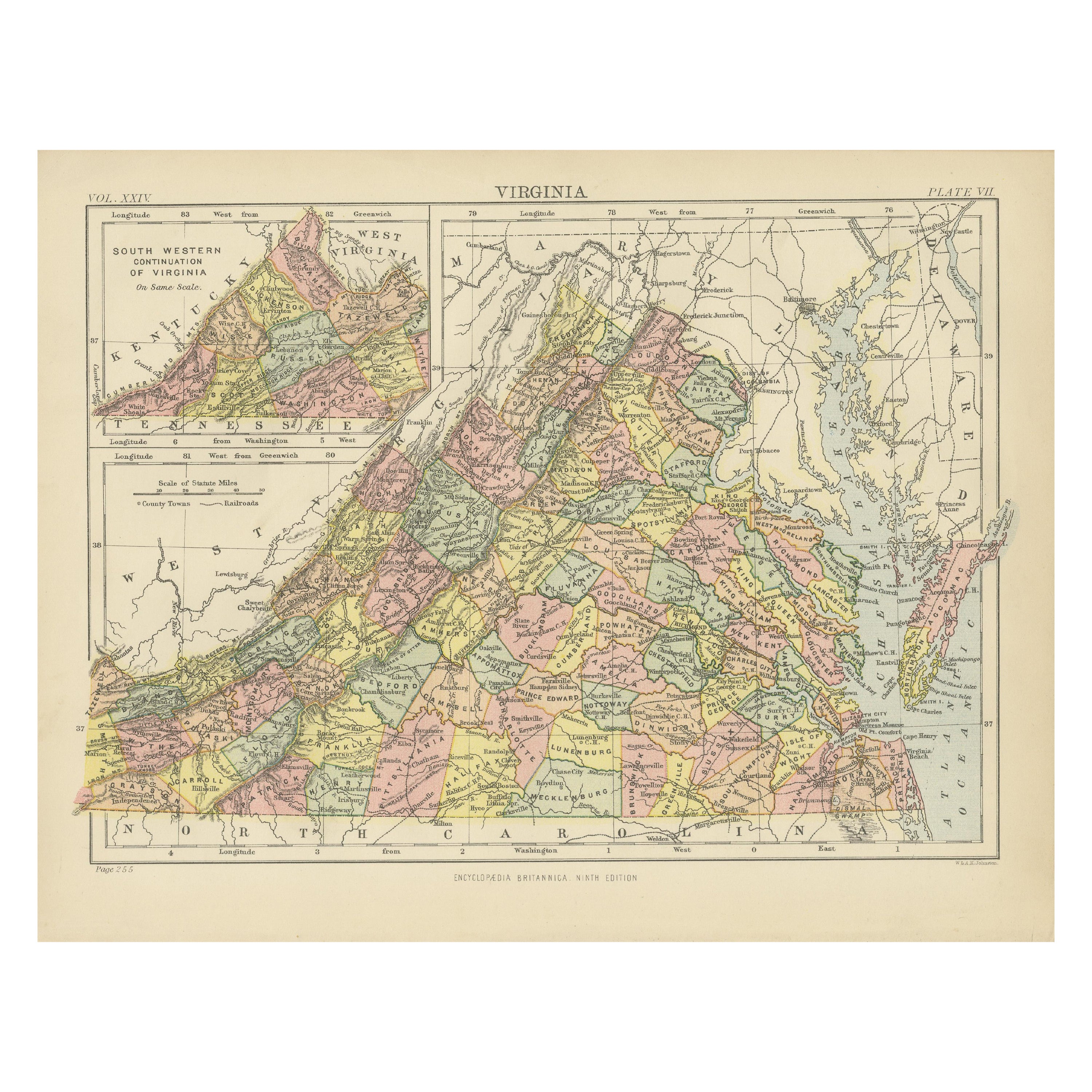
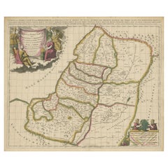
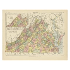
Antique Map of Virginia, Showing the Location of Civil War Battle Fields, 1902
View Similar Items


Want more images or videos?
Request additional images or videos from the seller
1 of 5
Antique Map of Virginia, Showing the Location of Civil War Battle Fields, 1902
About the Item
- Dimensions:Height: 24.5 in (62.23 cm)Width: 37 in (93.98 cm)Depth: 1 in (2.54 cm)
- Materials and Techniques:
- Place of Origin:
- Period:1900-1909
- Date of Manufacture:1902
- Condition:Wear consistent with age and use. Overall very good condition. The map features bright coloring with very minor fold lines. Many battlefields are marked in red ink notations. Framed according to conservation standards in a custom frame.
- Seller Location:Colorado Springs, CO
- Reference Number:Seller: M1961stDibs: LU909717756692
About the Seller
4.9
Platinum Seller
These expertly vetted sellers are 1stDibs' most experienced sellers and are rated highest by our customers.
Established in 2010
1stDibs seller since 2011
400 sales on 1stDibs
More From This SellerView All
- Civil War Panorama of the Seat of War by John Bachmann, Antique Print circa 1864Located in Colorado Springs, COPanorama of the seat of war. Bird's-eye View of Virginia, Maryland, Delaware and the District of Columbia. This third state of this fascinating bird's eye view of the northernmost p...Category
Antique 1860s American Maps
MaterialsPaper
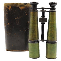
- Vintage Civil War Era Field Glasses by Queen & Co.Located in Colorado Springs, COPresented is an original pair of Civil War-era field glasses. The glasses, an intricate example of brass and glass technology, were made in Philadelphia, Pennsylvania by the company Queen & Co. The glasses are stamped “Queen & Co., Phila” along the eyepiece. They are housed in the original leather hard case. The glasses were most likely made in the early 1860s. Binoculars were first invented in France in the 1840s. They started small, primarily as opera glasses, but by the Civil War, they were being used in battle. Larger versions, like the pair seen here, became known as field glasses. Unlike Civil War uniforms...Category
Antique 1860s American Historical Memorabilia
MaterialsBrass
- 1837 Mitchell's "Tourist's Pocket Map of the State of Virginia" by J.H. YoungLocated in Colorado Springs, COThis is J. H. Young's pocket map of the Virginia, which shows county development current to 1835. The map was engraved by E. Yeager and F. Dankworth and published by S. A. Mitchell. ...Category
Antique 1830s American Maps
MaterialsPaper
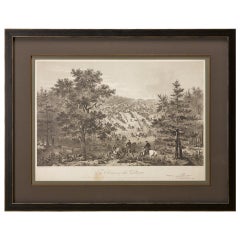
- "Army of the Potomac" by John Bachelder, Civil War Era Lithograph, circa 1863Located in Colorado Springs, COFully-entitled: Army of the Potomac. The Wagon Trains of the Army of the Potomac en Route from Chickahominy to James River VA. During the Seven...Category
Antique 19th Century American Prints
MaterialsPaper
- 1861 Topographical Map of the District of Columbia, by Boschke, Antique MapLocated in Colorado Springs, COPresented is an original map of Albert Boschke's extremely sought-after "Topographical Map of the District of Columbia Surveyed in the Years 1856 ...Category
Antique 1860s American Historical Memorabilia
MaterialsPaper
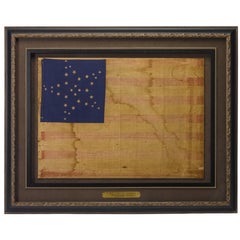
- 34-Star Civil War American Flag, Antique Great Star Pattern, circa 1861Located in Colorado Springs, COThe stars of this extremely rare, Civil War-era flag are arranged in what is sometimes called the "Great Flower" pattern, a large star made out of smaller stars -- named as such beca...Category
Antique 1860s American Political and Patriotic Memorabilia
MaterialsLinen
 $15,500 Sale Price37% Off


You May Also Like
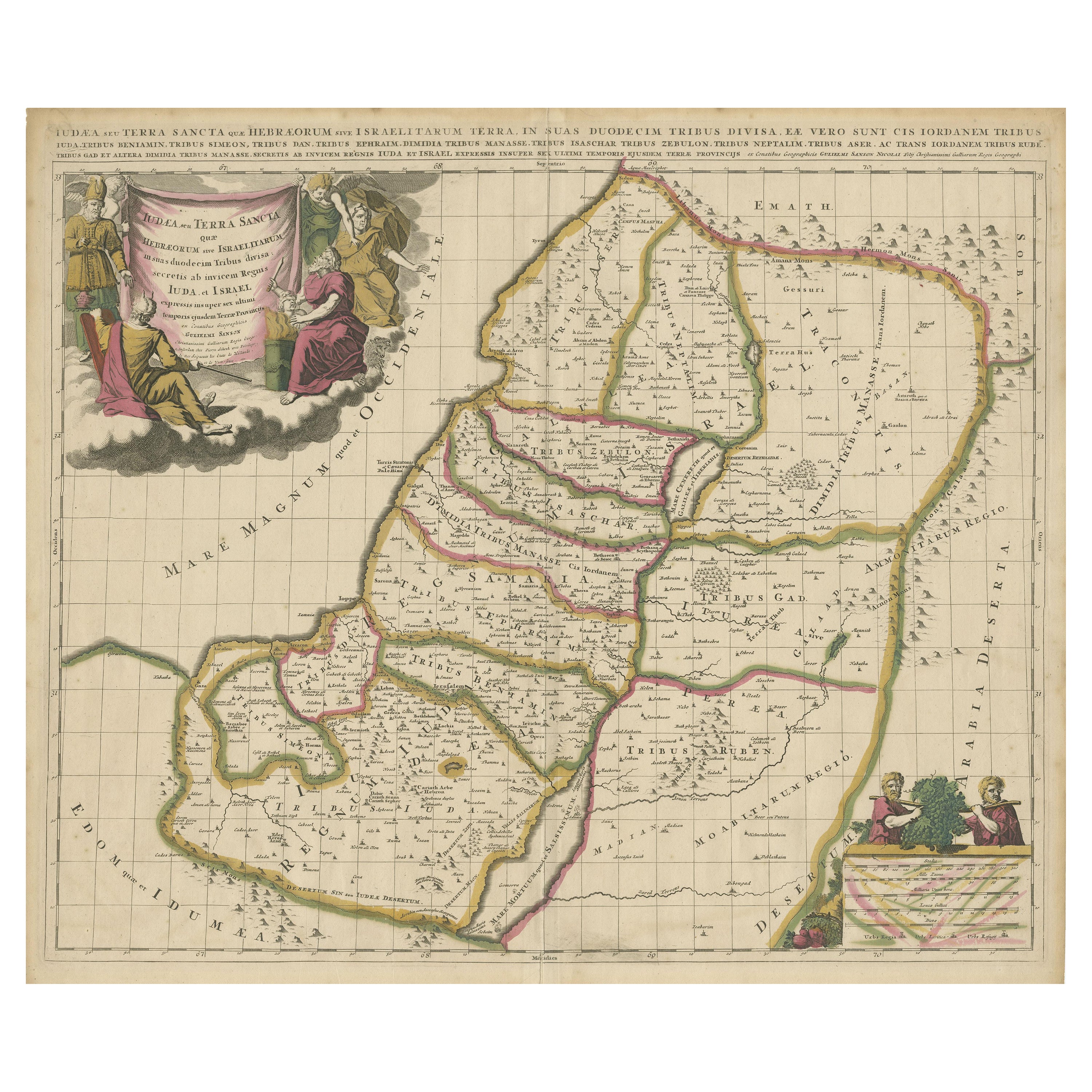
- Antique Map of the Holy Land, Showing the Location of the Various TribesLocated in Langweer, NLAntique map titled 'Judaea seu Terra Sancta quae Hebraeorum sive Israelitarum (..)'. Map of The Holy Land, showing the location of the various tribes, in two kingdoms, Judah and Isra...Category
Antique Early 18th Century Maps
MaterialsPaper
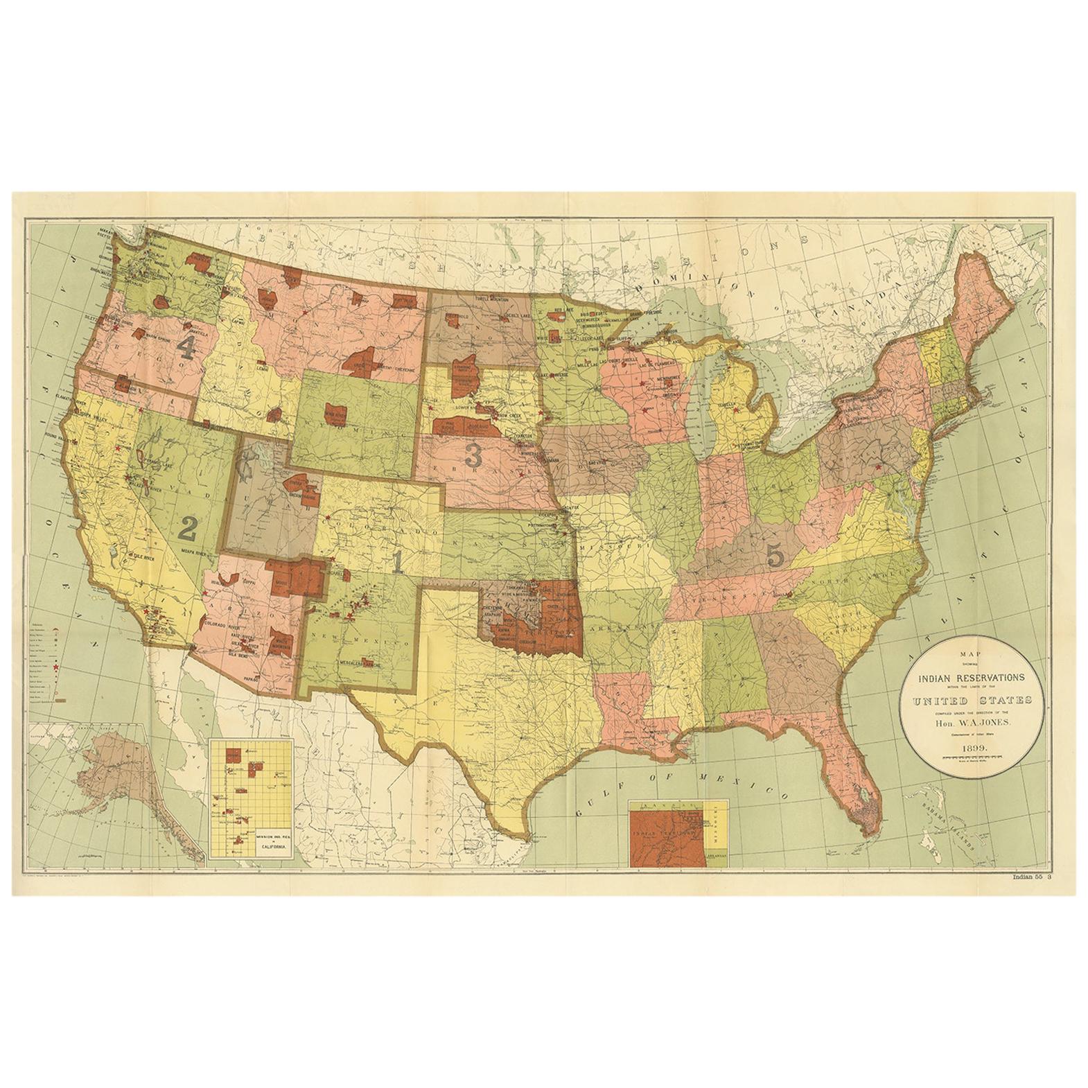
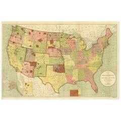
- Antique Map Showing the Locations of Native American Tribes in 1899Located in Langweer, NLAntique map titled 'Map showing the Indian Reservations within the Limits of the United States'. Large folding map of the United States showing the Indian Reservations. The present m...Category
Antique Late 19th Century Maps
MaterialsPaper
 $350 Sale Price50% Off
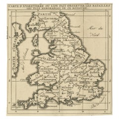
 - Original Antique Map of England, Showing the Most Memorable BattlesLocated in Langweer, NLAntique map titled 'Carte d'Angleterre ou l'on fait observer les Batailes les plus Memorables de ce Royaume'. Original antique map of England, showing the most memorable battles. Thi...Category
Antique Early 18th Century Maps
MaterialsPaper
 $192 Sale Price20% Off
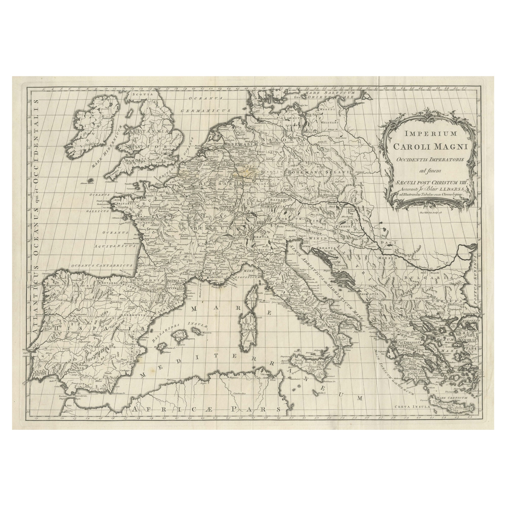
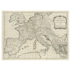
 - Large Antique Map of Europe, Showing the Empire of CharlemagneLocated in Langweer, NLAntique map titled 'Imperium Caroli Magni (..)'. Large antique map of Europe, showing the Empire of Charlemagne in the 8th Century. Engraved by T. Kitchin. Published J. Blair, circa ...Category
Antique Late 18th Century Maps
MaterialsPaper
- Antique Map of Virginia, with Inset Map of the South Western ContinuationLocated in Langweer, NLAntique map titled 'Virginia'. Original antique map of Virginia, United States. With inset map of the south western continuation of Virginia. T...Category
Antique Late 19th Century Maps
MaterialsPaper
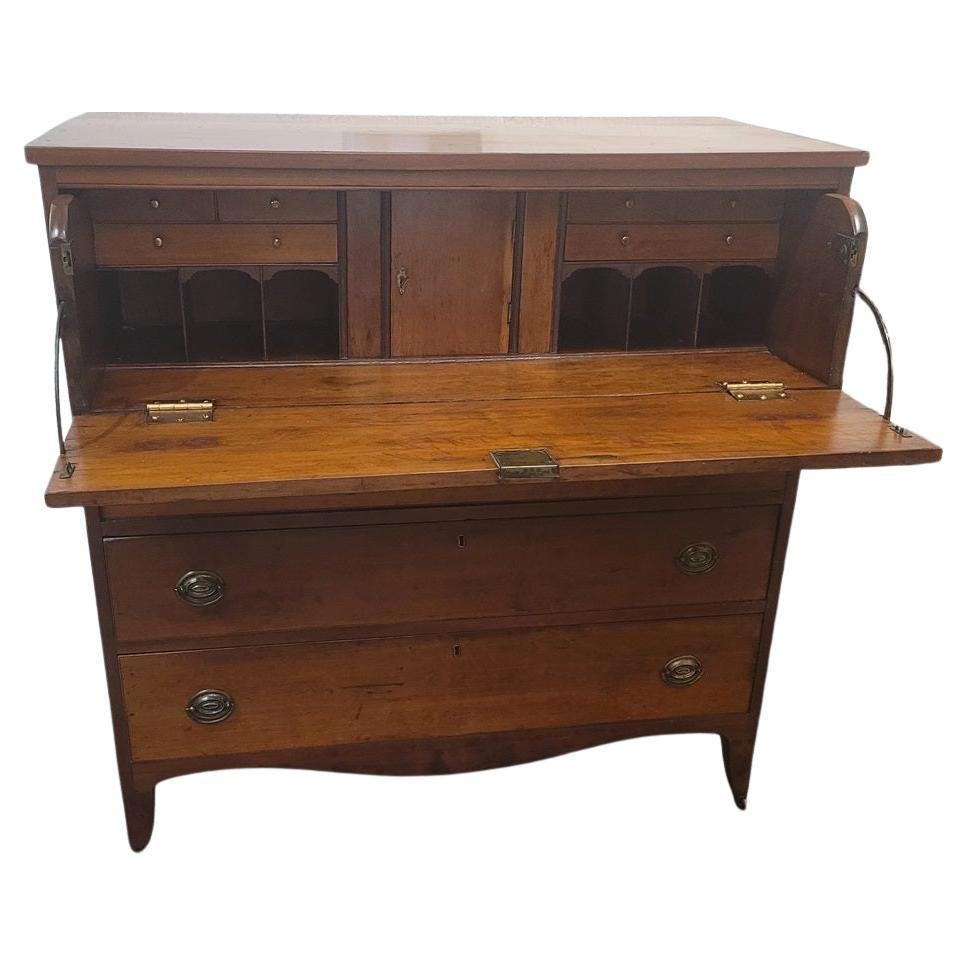
- American Hepplewhite Virginian Secretary Chest with Civil War ProvenanceBy George HepplewhiteLocated in Dallas, TXPRESENTING a FANTASTIC and HISTORIC Early 19C American Hepplewhite Virginian Secretary Chest with OUTSTANDING Provenance. This Secretary Chest was made in Virginia in the Early 19th Century, circa 1810. It is made of cherry, walnut and maple and is most definitely in the Hepplewhite Style of the period, with it’s original Hepplewhite brass drawer pulls. IT IS A REALLY INTRIGUING AND HISTORIC PIECE, ESPECIALLY, WHEN VIEWED IN CONTEXT WITH IT”S AMAZING PROVENANCE! This piece was originally owned by Major William Alexander Obenchain who ‘hailed’ from the State of Virginia. He was an engineer and was in the Virginia Corps of Engineers during the Civil War and served on General Robert E. Lee’s staff. It was acquired by him before the Civil War and we believe that this piece was on campaign with him during the War. We know for a fact that he fought at the Richmond Campaign in 1864, as we have, in our Collection, his original Field Map for that Campaign which ended the War. It has remained in family ownership ever since. It has come directly from the Family Estate, together with other VERY IMPORTANT items belonging to Major Obenchain and other IMPORTANT items that belonged to his wife, Eliza Calvert Hall-Obenchain. ALL these items contained in the Collection, are listed/posted individually on our Website. The top drawer is on retractable curved side hinge supports and pulls outwards and drops to reveal a secretary and writing area. The Bureau/Secretary Gallery has 6 drawers and 6 cubbies, a central tabernacle door with another drawer and 2 cubbies and this is flanked by 2 secret pull out compartments. The central tabernacle door has it’s original key and working lock. Closed, it is almost ‘flush’ like the rest of the drawers, with some very minor bowing through age. The 3 drawers underneath are graduated in size and it ends with a serpentine shaped base and sits on four hand carved legs with original metal casters, marked ‘Universal 3’. It has it’s original brasses and hardware throughout, save the addition to 2 contemporary replacement brass hinges to the drop down desk front, as the original hinges were broken, could not be repaired and were not supporting the weight of the drop down leaf. Some minor repairs but not noticeable. Otherwise, the piece is in it’s entirely, ORIGINAL condition! What makes this piece even MORE INTRIGUING and APPEALING HISTORICALLY, are the 2 ‘historic’ circular holes on the piece:- (1) in the back of the piece as seen in the photos. This hole is not symmetrical or fully round and appears to serve no purpose to the piece whatsoever. Sometimes, pieces have holes for wiring for lighting, put in them over the years, but this one never had such lighting or, indeed, any such explanation for this hole, AND (2) the rear hole is replicated, in the corner portion of the bottom drawer and someone (a very long time ago) has used a tin can top, to cover the hole in the back of the drawer. The tin can top is period to the Civil War Era and is embossed “Minimum Volume 1 Pint”. Our conclusion, is that (whilst we are, by no means ballistic experts) that these holes were created by musket balls, fired during one of the Major’s campaigns in the Civil War. It is entirely conceivable that this piece, being strapped into a covered wagon for carriage, would have been on it’s side. We are of the opinion that both holes, were caused or created by a musket ball entered the chest trough the base and back. We also believe that ‘the Major’, used what he had at his disposal on the battlefield, namely, a tin can lid to repair the hole in the drawer. SO THIS PIECE IS A VERY SPECIAL PIECE OF US HISTORY, INDEED! NOT ONLY IS IT AN EARLY 19th CENTURY AMERICAN PIECE, WITH A CONNECTION TO THE STATE OF VIRGINIA, THE CIVIL WAR, HISTORIC & IMPORTANT FIGURES IN THAT WAR AND IMPECCABLE PROVENANCE AND HISTORY! IT IS TRULY UNIQUE! William Alexander Obenchain. Born April 27, 1841 at Buchanan, Botetourt Co., Virginia. Parents: Thomas Jefferson Obenchain and Elizabeth Ann Sweetland. Entered VMI on July 18, 1859 as a member of the VMI (Virginia Military Institute...Category
Antique Early 19th Century American American Classical Historical Memora...
MaterialsBrass
Recently Viewed
View AllMore Ways To Browse
Antique West Virginia
Railroad Collectibles
Maryland Map
Map Of Maryland
Battle Maps
Map Of Washington D C
Antique Railroad Collectibles Collectibles
Antique Railroad Collectables
Antique Railroad Collectibles
Civil War Map
Virginia Maps
Virginia Map
Map Of Virginia
Antique Battle Maps
Antique Civil War Maps
Antique Railroad Maps
Virginia Confederate
Map Railroad