Items Similar to Antique Bird's-Eye View of Hangzhou (China) by Matthäus Merian, 1638
Want more images or videos?
Request additional images or videos from the seller
1 of 7
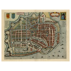
Antique Bird's-Eye View of Hangzhou (China) by Matthäus Merian, 1638
$1,027.77
£760.86
€860
CA$1,422.18
A$1,567.68
CHF 820.29
MX$19,234.95
NOK 10,325.76
SEK 9,656.22
DKK 6,548.04
About the Item
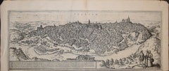
This is an exquisite antique bird's-eye view map of Hangzhou, historically referred to as "Xuntien or Quinzay," from the first edition of Matthäus Merian's publication in 1638. This copper engraving, originally created for "Newe Archontologia Cosmica" by Johann Ludwig Gottfried and Matthäus Merian, presents an artistically detailed representation of Hangzhou, celebrated as one of China's seven ancient capitals. The dimensions of the engraved area are 18 x 25.5 cm (7 x 9.9 inches), with the verso blank.
The view is based on Marco Polo's renowned accounts of Hangzhou, or Quinzay—a corrupted version of "King-sze," which translates to "capital" or "great city." The portrayal highlights its sprawling layout, extensive waterways, iconic architecture, and bustling activity, encapsulating the grandeur and vitality of this significant historical city during the Ming Dynasty.
What makes this map particularly compelling for collectors is its connection to Marco Polo's travels and its unique Western perspective on an ancient Chinese city, reflecting early European impressions of the East. As part of Merian’s oeuvre, it exemplifies his expertise in creating visually captivating and meticulously detailed cartographic works.
The condition of this map is remarkable. It features a fine dark impression with no significant flaws, earning it a condition rating of A+. The sheet itself is clean, and the engraving lines are sharp and clear, ensuring that every detail is visible. Such excellent preservation enhances its appeal to collectors, scholars, and enthusiasts of historical maps.
This engraving is a rare piece for its historical, artistic, and cultural value, providing a fascinating glimpse into 17th-century European perceptions of one of China's most illustrious cities. Its combination of historical significance, artistry, and fine condition makes it a standout acquisition for anyone interested in early cartography or East Asian history.
- Dimensions:Height: 12.41 in (31.5 cm)Width: 14.77 in (37.5 cm)Depth: 0.01 in (0.2 mm)
- Materials and Techniques:Paper,Engraved
- Period:1630-1639
- Date of Manufacture:1638
- Condition:Fine dark impression, very good condition, especially considering age. Clean sheet, sharp engraving lines, later hand-colouring.
- Seller Location:Langweer, NL
- Reference Number:Seller: BG-139131stDibs: LU3054342680282
About the Seller
5.0
Recognized Seller
These prestigious sellers are industry leaders and represent the highest echelon for item quality and design.
Platinum Seller
Premium sellers with a 4.7+ rating and 24-hour response times
Established in 2009
1stDibs seller since 2017
2,615 sales on 1stDibs
Typical response time: <1 hour
- ShippingRetrieving quote...Shipping from: Langweer, Netherlands
- Return Policy
Authenticity Guarantee
In the unlikely event there’s an issue with an item’s authenticity, contact us within 1 year for a full refund. DetailsMoney-Back Guarantee
If your item is not as described, is damaged in transit, or does not arrive, contact us within 7 days for a full refund. Details24-Hour Cancellation
You have a 24-hour grace period in which to reconsider your purchase, with no questions asked.Vetted Professional Sellers
Our world-class sellers must adhere to strict standards for service and quality, maintaining the integrity of our listings.Price-Match Guarantee
If you find that a seller listed the same item for a lower price elsewhere, we’ll match it.Trusted Global Delivery
Our best-in-class carrier network provides specialized shipping options worldwide, including custom delivery.More From This Seller
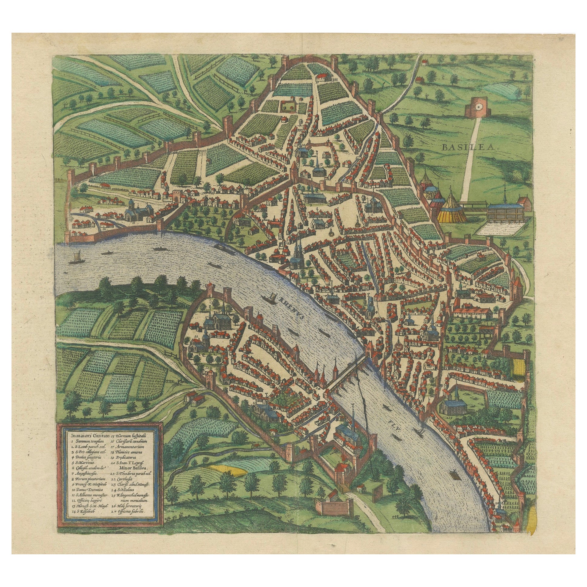
View AllBird’s-Eye View of Basel from Braun & Hogenberg’s Civitates Orbis Terrarum, 1575
Located in Langweer, NL
Bird’s-Eye View of Basel from Braun & Hogenberg’s "Civitates Orbis Terrarum" (Circa 1572-1617)
This highly detailed map of Basel is a bird's-eye view, originally based on Sebastian Münster’s map...
Category
Antique 16th Century Maps
Materials
Paper
$1,147 Sale Price
20% Off
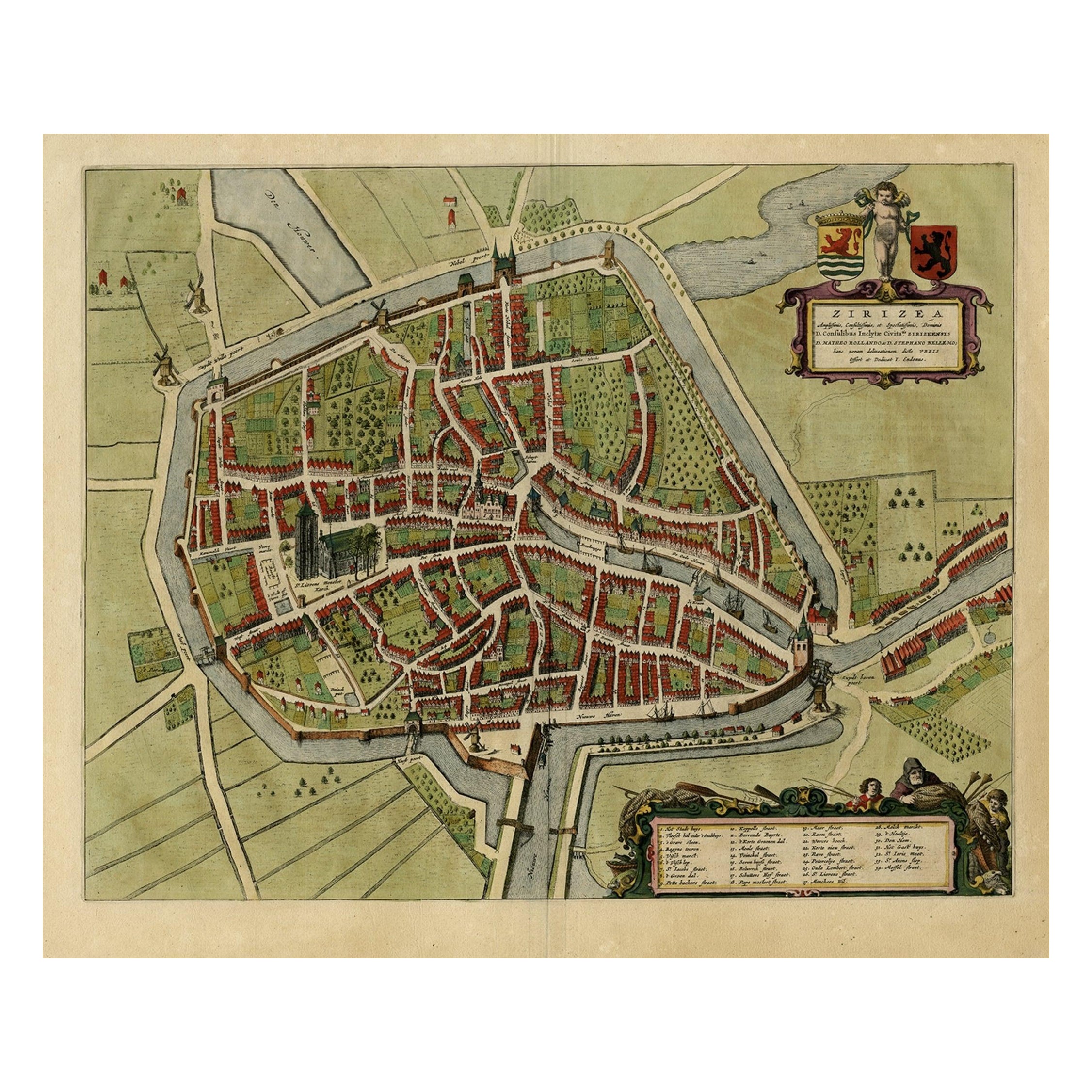
Antique Bird's-eye View Plan of Zierikzee in Zeeland, The Netherlands, 1649
Located in Langweer, NL
Antique print, titled: 'Zirizea.' - A bird's-eye view plan of Zierikzee in The Netherlands, with key to locations and coats of arms. After Matheo Rollando and Stephano Bellemo. Latin tekst on verso. From the city Atlas: 'Toneel der Steeden' published by Joan Blaeu...
Category
Antique 1640s Maps
Materials
Paper
$1,099 Sale Price
20% Off
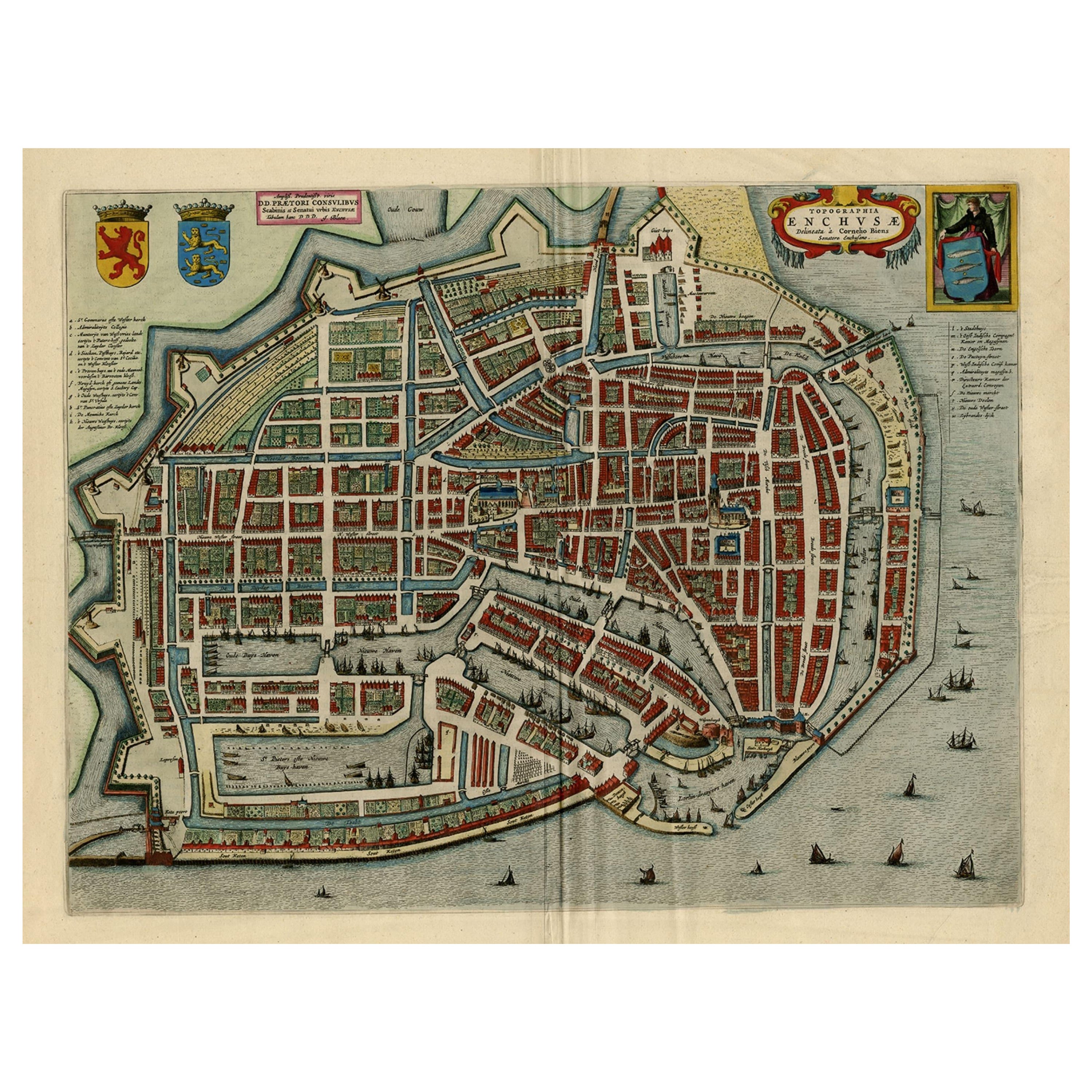
Beautiful Bird's-Eye View Plan of Enkhuizen in The Netherlands by Blaeu, 1649
Located in Langweer, NL
Antique print, titled: 'Topograhpiae Enchusae.'
Bird's-eye view plan of Enkhuizen in The Netherlands, with key to locations and coats of arms. Text in Dutch on verso. This plan o...
Category
Antique 1640s Maps
Materials
Paper
$1,099 Sale Price
20% Off
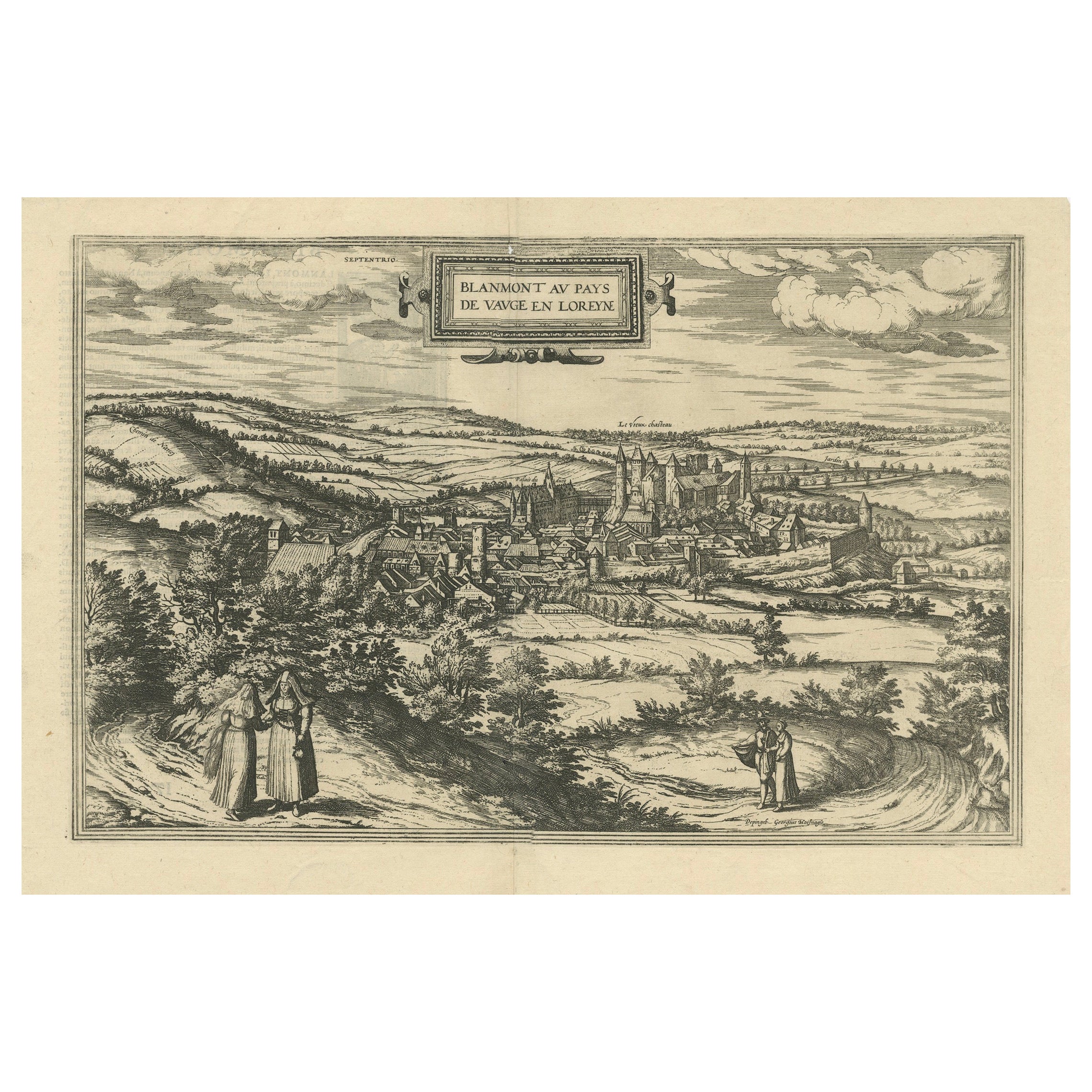
Bird's-Eye View of Blâmont in Lorraine by Braun and Hogenberg, 1597
Located in Langweer, NL
Title: Bird's-Eye View of Blâmont in Lorraine by Braun and Hogenberg, 1597
This copperplate engraving, published in 1597 by Braun and Hogenberg, depicts a bird's-eye view of the t...
Category
Antique 16th Century Maps
Materials
Paper
$401 Sale Price
30% Off
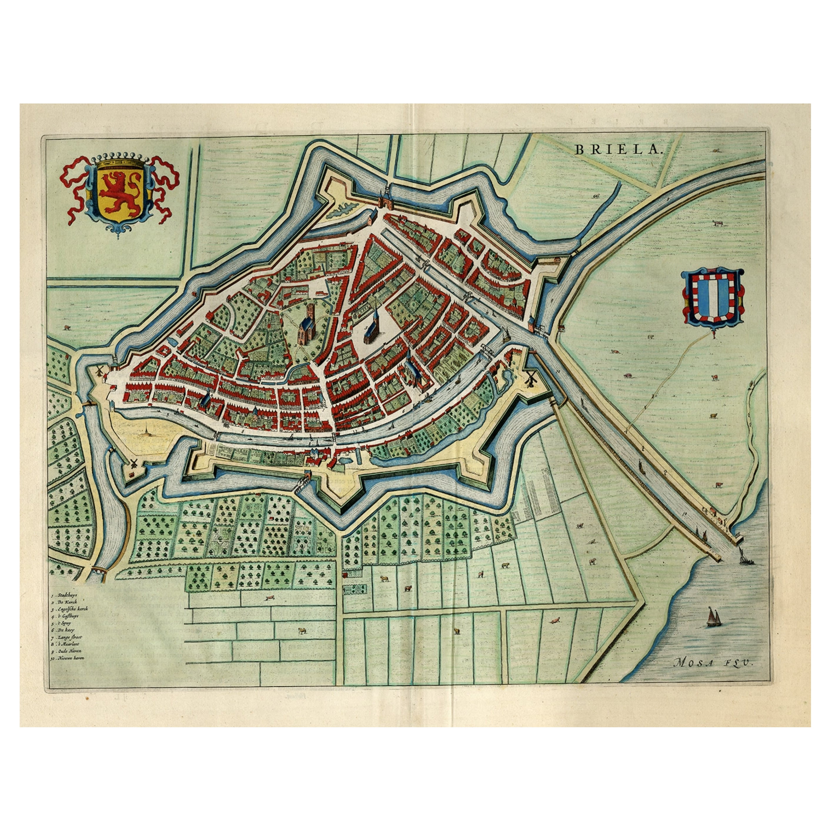
Great Antique Bird's-Eye View Plan of Brielle by Blaeu in The Netherlands, 1649
Located in Langweer, NL
Antique print, titled: 'Briela.'
Bird's-eye view plan of Brielle in The Netherlands. With key to locations and coats of arms. Text in Dutch on verso. This plan originates from the famous city Atlas: 'Toneel der Steeden' published by Joan Blaeu...
Category
Antique 1640s Maps
Materials
Paper
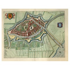
$1,195 Sale Price
20% Off
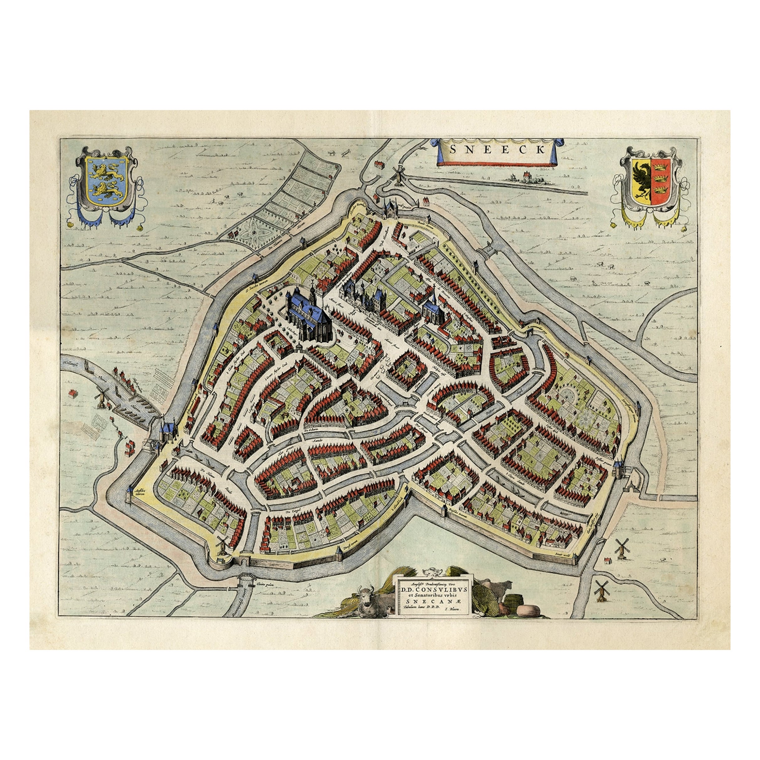
Original Old Bird's-eye View plan of Sneek, Friesland, The Netherlands, 1649
Located in Langweer, NL
Antique map titled: 'Sneeck.' Bird's-eye view plan of Sneek, Friesland, The Netherlands. Text in Latin on verso. This plan originates from the famous city Atlas: 'Toneel der Steeden'...
Category
Antique 1640s Maps
Materials
Paper
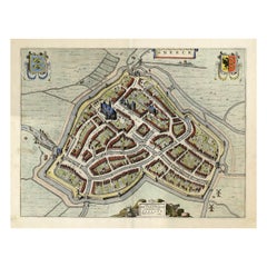
$1,099 Sale Price
20% Off
You May Also Like
17th Century Topographical Engraving Nantes & St. Malo, France, by Iohan Peeters
Located in New York, NY
The ancient city of Saint Malo in North Western France has long been associated with adventure on the high seas, piracy and exploration. It was the birthplace of several important in...
Category
Antique 17th Century Dutch Maps
Materials
Paper

Utrecht, Antique Map from "Civitates Orbis Terrarum"
By Franz Hogenberg
Located in Roma, IT
Braun G., Hogenberg F., Traiectum or Utrecht, from the collection Civitates Orbis Terrarum, Cologne, T. Graminaeus, 1572-1617.
Very fine B/W aquatint showing a view of Utrecht, with...
Category
16th Century Landscape Prints
Materials
Etching

17th Century Toulouse, Savve, Sommieres Topographical Map by Iohan Peeters
Located in New York, NY
Fine topographical 17th century map of Toulouse, Savve and Sommieres by Iohan Peeters
Beautiful engraving of the capital of France's Occitanie Region, Toulouse, called La Ville Rose- the Pink City, for the terracotta bricks used in its many buildings, giving the city a distinct apricot-rose hue. An important cultural and educational center, the city's residents included Nobel Prize winners and world renown artists- Henri de Toulouse-Lautrec, Henri Martin, Jean-Auguste-Dominique Ingres, Antonin Mercie, Alexandre Falguiere and more recently Cyril Kongo...
Category
Antique 17th Century Dutch Maps
Materials
Paper

Framed 1731 Color Engraving, Map of Rotterdam by Matthaus Seutter, "Roterodami"
Located in Bridgeport, CT
"Roterodami". Seutter (1678-1757) was an important German 18th century map maker. Bird's eye view of the city above with full details, neoclassi...
Category
Antique 18th Century European Renaissance Maps
Materials
Glass, Wood, Paper

Map of Nijmegen - Etching by G. Braun and F. Hogenberg - Late 16th Century
By Franz Hogenberg
Located in Roma, IT
This map of Noviomagvs is an original etching realized by Georg Braun and Franz Hogenberg as part of the famous series "Civitates Orbis Terrarum".
The state of preservation of the ...
Category
16th Century Figurative Prints
Materials
Etching

Toledo, Map from "Civitates Orbis Terrarum" - by F. Hogenberg - 1575
By Franz Hogenberg
Located in Roma, IT
Braun G., Hogenberg F., "Toledo", from the collection "Civitates Orbis Terrarum", Cologne, T. Graminaeus, 1572-1617. Image Dim: cm 19 x 48 , Dim: cm 22. 5 x 52.5 .
Very nice B/W Aquatint representing a View of Toledo...
Category
16th Century Figurative Prints
Materials
Etching, Aquatint
More Ways To Browse
Marco Polo
King Ludwig
China Silk Rug
Early English Silver
Italian Carved Dining Set
Antique Silver Basket
Black Crystal Glasses
Baker Furniture By
Oak Library
T Chair
Antique Italian Chairs
Antique Victorian Dining Tables
Veneer Dining Tables
Antique Brass And Copper
Antique English Country Furniture
Antique Russian Rugs
Beni Ourain Rugs
Glass Top Wood Base Coffee Tables