Items Similar to Antique Engraving of the Islands Wanooa, Wateeoo, Mangeea, Toobouai, Cook, 1803

Want more images or videos?
Request additional images or videos from the seller
1 of 6
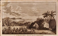
Antique Engraving of the Islands Wanooa, Wateeoo, Mangeea, Toobouai, Cook, 1803
$268.79
$335.9820% Off
£198.22
£247.7720% Off
€224
€28020% Off
CA$371.19
CA$463.9920% Off
A$407.28
A$509.1020% Off
CHF 213.15
CHF 266.4420% Off
MX$5,012.28
MX$6,265.3520% Off
NOK 2,685.41
NOK 3,356.7720% Off
SEK 2,515.29
SEK 3,144.1120% Off
DKK 1,706.04
DKK 2,132.5420% Off
About the Item
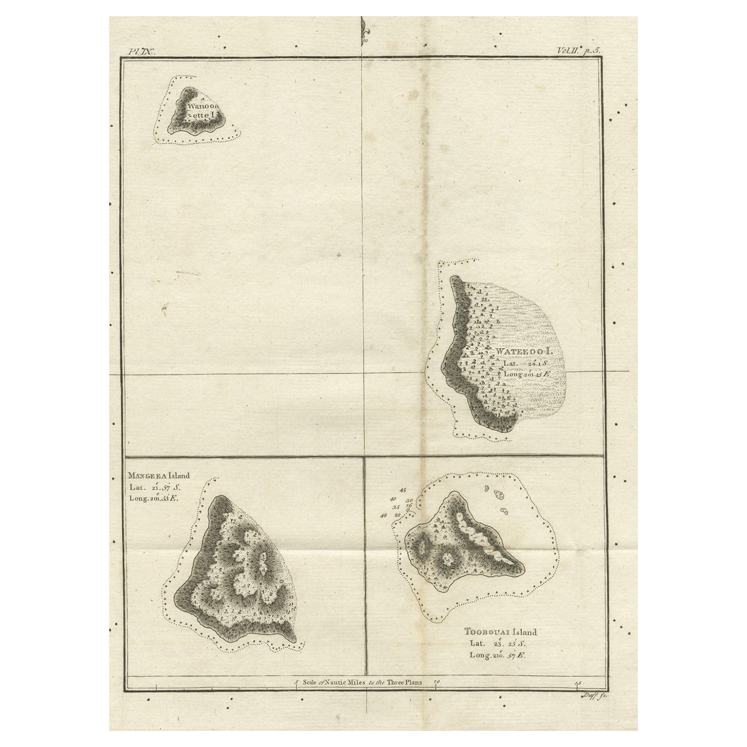
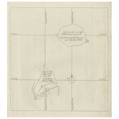
Antique map South Pacific Islands, Polynesia. Originates from 'Reizen Rondom de Waereld door James Cook (..)'.
Artists and Engravers: Translated by J.D. Pasteur. Published by Honkoop, Allart en Van Cleef.
Condition: Very good, minor foxing. Please study image carefully.
Date: 1803
Overall size: 21 x 27 cm.
Image size: 17 x 22 cm.
We sell original antique maps to collectors, historians, educators and interior decorators all over the world. Our collection includes a wide range of authentic antique maps from the 16th to the 20th centuries. Buying and collecting antique maps is a tradition that goes back hundreds of years. Antique maps have proved a richly rewarding investment over the past decade, thanks to a growing appreciation of their unique historical appeal. Today the decorative qualities of antique maps are widely recognized by interior designers who appreciate their beauty and design flexibility. Depending on the individual map, presentation, and context, a rare or antique map can be modern, traditional, abstract, figurative, serious or whimsical. We offer a wide range of authentic antique maps for any budget.
- Dimensions:Height: 10.63 in (27 cm)Width: 8.27 in (21 cm)Depth: 0 in (0.01 mm)
- Materials and Techniques:
- Period:
- Date of Manufacture:1803
- Condition:Condition: Very good, minor foxing. Please study image carefully.
- Seller Location:Langweer, NL
- Reference Number:Seller: BG-094951stDibs: LU3054329625752
About the Seller
5.0
Recognized Seller
These prestigious sellers are industry leaders and represent the highest echelon for item quality and design.
Platinum Seller
Premium sellers with a 4.7+ rating and 24-hour response times
Established in 2009
1stDibs seller since 2017
2,618 sales on 1stDibs
Typical response time: <1 hour
- ShippingRetrieving quote...Shipping from: Langweer, Netherlands
- Return Policy
Authenticity Guarantee
In the unlikely event there’s an issue with an item’s authenticity, contact us within 1 year for a full refund. DetailsMoney-Back Guarantee
If your item is not as described, is damaged in transit, or does not arrive, contact us within 7 days for a full refund. Details24-Hour Cancellation
You have a 24-hour grace period in which to reconsider your purchase, with no questions asked.Vetted Professional Sellers
Our world-class sellers must adhere to strict standards for service and quality, maintaining the integrity of our listings.Price-Match Guarantee
If you find that a seller listed the same item for a lower price elsewhere, we’ll match it.Trusted Global Delivery
Our best-in-class carrier network provides specialized shipping options worldwide, including custom delivery.More From This Seller
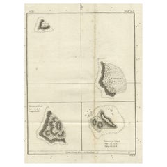
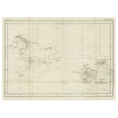
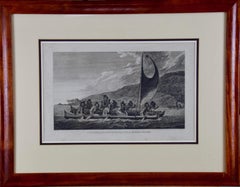
View AllOld Map of the Cook Islands Takutea, Atiu, Mangaiac and Tubuai, Polynesia, 1781
Located in Langweer, NL
Antique map titled 'Mangeea Island, Toobouai Island (..)'. Map of three of the Cook Islands: Wanooaette [i.e. Takutea] Island, Wateeoo [i.e. Tui or Atiu] ...
Category
Antique 18th Century Maps
Materials
Paper
$124 Sale Price
20% Off
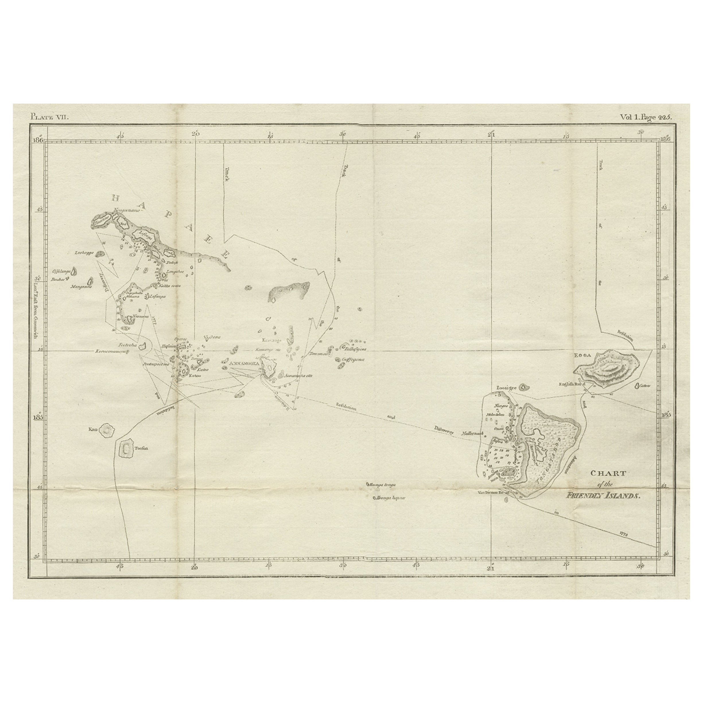
Antique Engraved Map of the Friendly Islands or Tonga, ca.1785
Located in Langweer, NL
Antique map titled 'Carte des Isles des Amis'.
Map of the Friendly Islands / Tonga. The Tongan people first encountered Europeans in 1616 when the Dutch vessel Eendracht, captain...
Category
Antique 1780s Maps
Materials
Paper

$307 Sale Price
20% Off
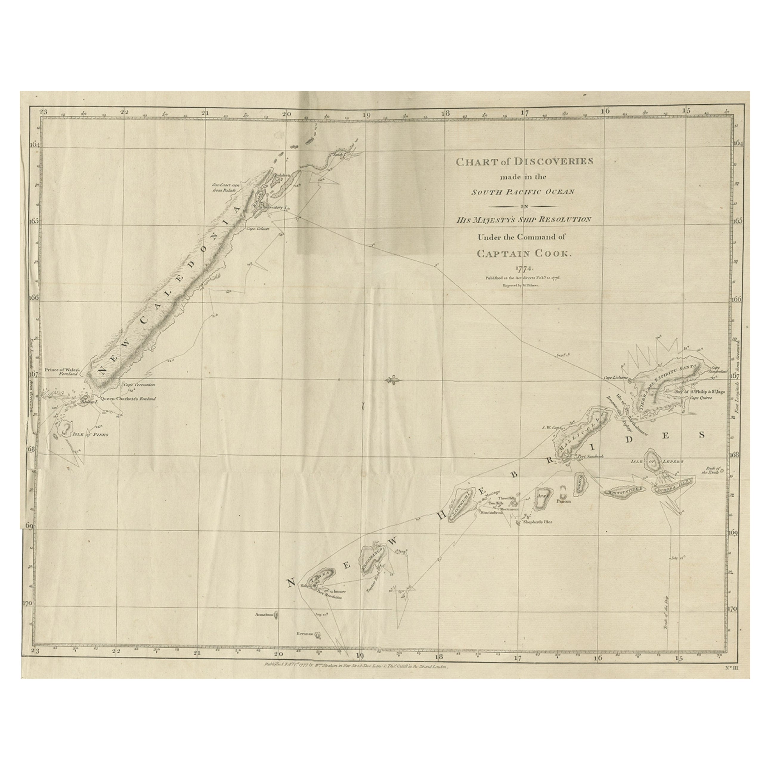
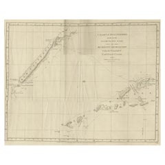
Rare Engraving of New Caledonia & New Hebrides from Capt. Cook's Travels, 1777
Located in Langweer, NL
Antique map titled 'Chart of Discoveries made in the South Pacific Ocean'.
Rare engraving from the official British Admiralty sanctioned edition of the accounts of Cook’s second voyage. All other later copies made of this image by other publishers were unauthorised, usually smaller and inferior in quality. Made after Cook's discovery of the island group on 4 September 1774, which he named New Caledonia...
Category
Antique 1770s Maps
Materials
Paper
$719 Sale Price
20% Off
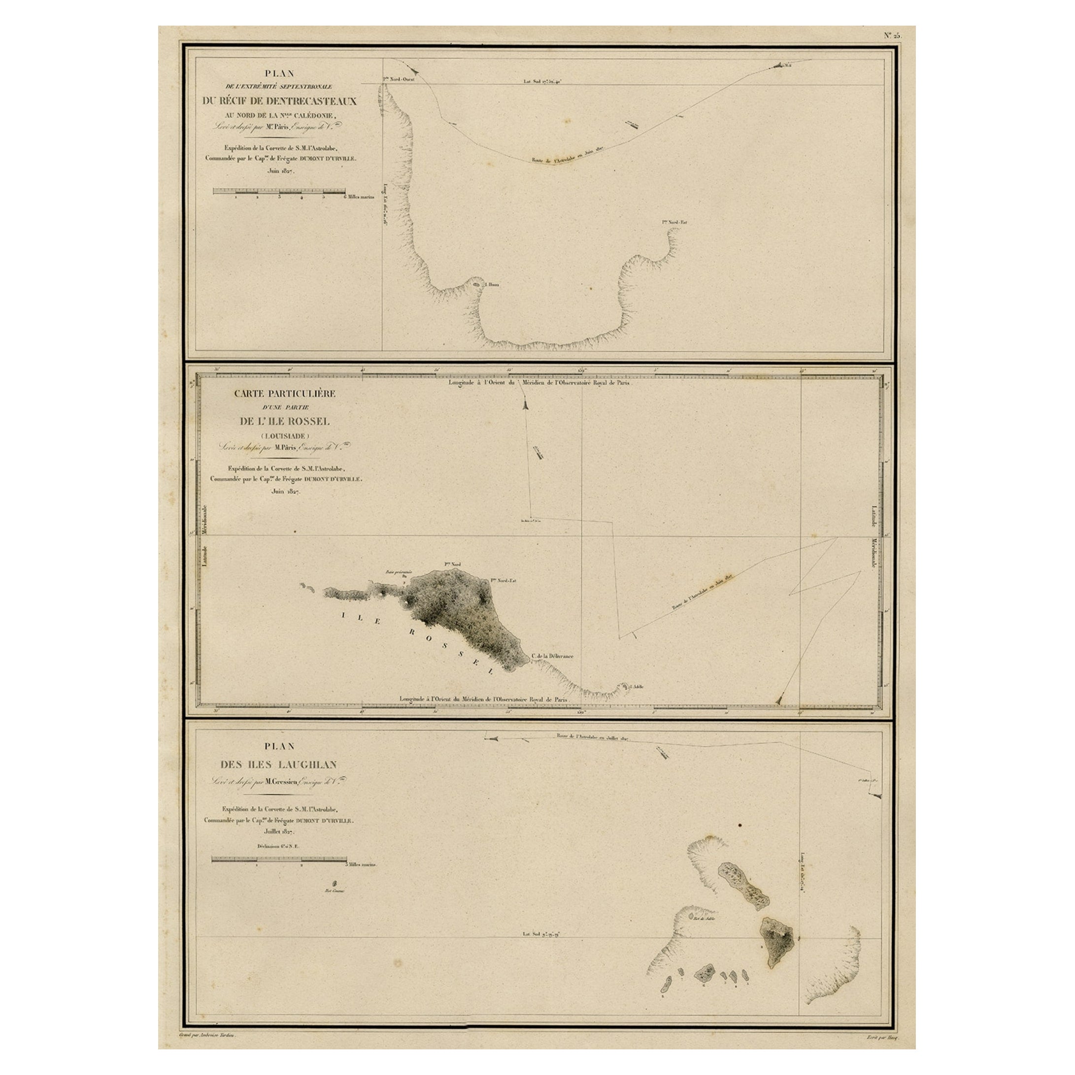
Map of the Laughlan Islands, Rossel Island & Reef North of New Caledonia, 1833
Located in Langweer, NL
Antique map titled 'Plan de l'extremite septentrionale du Recif de D'entrecasteaux. Carte Particuliere d'un partie de l'Ile Rossel (Louisiade). Plan des Iles Laughlan.'
Map of th...
Category
Antique 1830s Maps
Materials
Paper
$431 Sale Price
20% Off
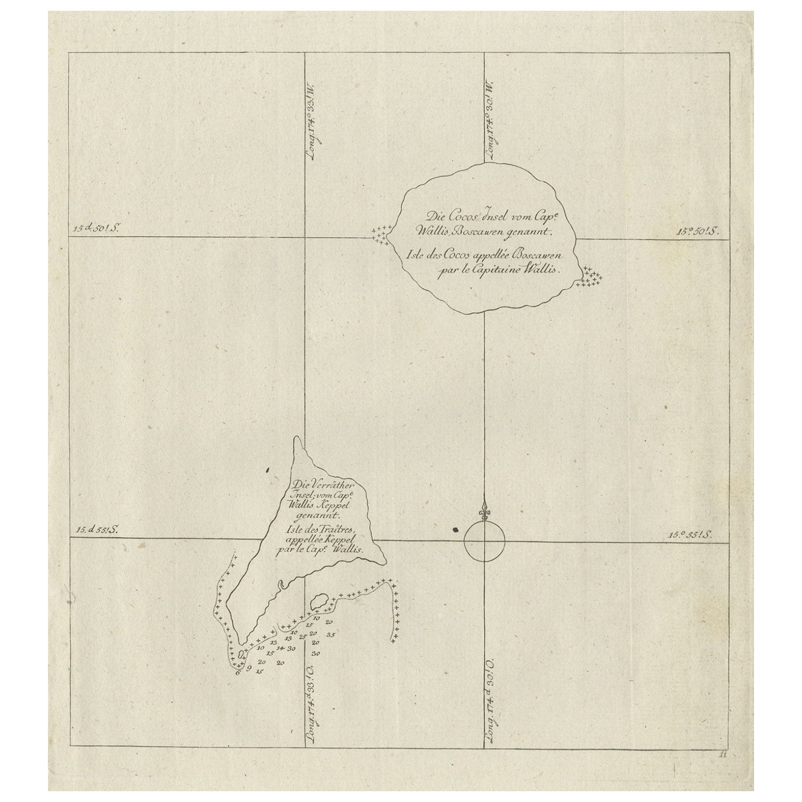
Antique Map of the Cocos or Keeling Islands, 1778
Located in Langweer, NL
Antique map titled 'Die Cocos Insel vom Capt. Wallis Bosawren. Die Verrather Islel von Capt. Wallis Keppel Genannt'. Also with French subtitles. Old map of the Cocos or Keeling Islan...
Category
Antique 18th Century Maps
Materials
Paper
$278 Sale Price
20% Off
Antique Chart of the Friendly Islands or Nowadays Tonga, by Cook, 1784
By James Cook
Located in Langweer, NL
Antique print titled 'Chart of the Friendly Islands'. Antique map of the Friendly Islands depicting Rotterdam or Anamocka, Middelburg or Eaoowe and Amsterdam or Tongatabu. Originates...
Category
Antique 18th Century Prints
Materials
Paper
$326 Sale Price
20% Off
You May Also Like
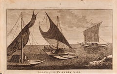
Boats of the Friendly Isles, Tonga: Original 18th C. Engraving from Captain Cook
By William Hodges
Located in Alamo, CA
"Boats of the Friendly Isles" is an original 18th century engraving from a drawing by William Hodges (1744-1797), who was the artist who accompanies Captain Cook on his second voyage...
Category
1780s Landscape Prints
Materials
Engraving
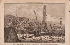
A View of Kauai, Hawaii Discovered by Captain Cook: Original 18th C. Engraving
By John Webber
Located in Alamo, CA
"View of A Morai or Burial Place of Atooi, One of the Sandwich Islands (Kauai, Hawaii)" is an original 18th century engraving from a drawing by John Webber (1751-1793), who was the a...
Category
1780s Landscape Prints
Materials
Engraving
Captain Cook's Exploration of Tahiti: 18th C. Hand-colored Map by Bellin
By Jacques-Nicolas Bellin
Located in Alamo, CA
This beautiful 18th century hand-colored copper plate engraved map is entitled "Carte de l'Isle de Taiti, par le Lieutenant J. Cook" was created by Jacques Nicolas Bellin and publish...
Category
Late 18th Century Landscape Prints
Materials
Engraving

A View of Kauai, Hawaii as Seen by Captain Cook: An Original 18th C. Engraving
By John Webber
Located in Alamo, CA
"An Inland View in Atooi, One of the Sandwich Islands (Kauai, Hawaii)" is an original 18th century engraving from a drawing by John Webber (1751-1793), who was the artist who accompa...
Category
1780s Landscape Prints
Materials
Engraving
Sandwich Islands Canoe (Hawaii): Framed 18th C. Engraving Captain Cook's Journal
By John Webber
Located in Alamo, CA
"A Canoe of the Sandwich Islands, the Rowers Masked" is an engraving created by Charles Grignion, from a drawing by John Webber (1752-1793), who was the artist on Captain James Cook's 3rd and final voyage of discovery. It is Plate 65 in the atlas of "A Voyage to the Pacific Ocean Undertaken by the Command of His Majesty, for Making Discoveries in the Northern Hemisphere", the official British Admiralty sanctioned journal published upon completion of the voyage in London in 1784 by Strahan & Cadell.
This famous image of ten Hawaiian rowers transporting a priest who is carrying a feather-covered image of Kukailimoku, the Hawaiian god of war. The priests and paddlers are all wearing gourd masks in their double-hulled canoe with an upright lateen woven sail. Each hull was shaped from a single large Koa log harvested from island rainforests, where they were carved before being transported to the coast.
This engraving is presented in a Koa wood frame and a white mat. There are occasional faint spots, but the print is otherwise in very good condition. Koa is the same wood as was used to make the canoe. Koa wood is legendary in Hawaii. Not only is this amazing wood native to Hawaii, but it is known for the deep rich colors and varied grain pattern. Koa has an honored heritage in Hawaii and is highly revered and sacred. The word “koa” means “warrior” in Hawaiian. The warriors of King Kamehameha the Great, created canoes and weapons from a wood plentiful on the Big Island of Hawaii. This wood became synonymous with the warriors themselves, and it became known as koa. The frame measures 20.75" high, 26.75" wide and 0.88" deep.
There are three other engravings listed from the official journal of Captain Cook's 3rd voyage available that are presented in identical Koa wood frames and mat (LU117324682022, LU117324684052, LU117324684062). They would make a wonderful grouping for a display of 2, 3 or 4 prints. A discount is available for a grouping depending on the number of items included.
Hawaii was discovered by Captain Cook (1728-1779) during this voyage. Hawaii was originally called The Sandwich Islands in honor of The Earl of Sandwich...
Category
1780s Landscape Prints
Materials
Engraving
Ancient Map of Oceania - Original Etching - 19th century
Located in Roma, IT
This Map of Oceania is an etching realized in the 19th century.
The state of preservation of the artwork is good. At the top of the paper, the inscription “Longitudine del Meridiano...
Category
19th Century More Prints
Materials
Etching

More Ways To Browse
Cook Islands
Antique Map Burgundy
Antique Map Of Hawaii
Antique Maps Of Long Island
Calcutta Map
Gibraltar Antique Map
Guyana Antique Map
Lancashire Map
Saudi Arabia Map
16th Century Scotland
Antique Leather Map
Antique Map Of Argentina
Antique Map Of Colombia
Cornwall Map
Early Texas Furniture
Rand Mcnally Vintage Maps
Tunisia Antique Map
Used Office Furniture Rhode Island