Items Similar to Antique Lithography Map, Durham, English, Framed, Cartography, Early Georgian


Want more images or videos?
Request additional images or videos from the seller
1 of 13
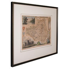
Antique Lithography Map, Durham, English, Framed, Cartography, Early Georgian
About the Item
This is an antique lithography map of Durham. An English, framed engraving of cartographic interest, dating to the early 18th century and later, circa 1720.
Superb lithography of Durham and its surrounding political wards
Displaying a desirable aged patina and in very good order
Fascinating cartography, appealingly set within a quality, later frame
Dressed to the rear with hanging cord for ease of mounting
Colourful shield to the upper corner - Dunelmensis or 'being of, or from Durham'
Includes the mapmaker's name and the dealer's names of Abel Smale & John Churchill
Coloured borders partition the wards of Chester, Derlington and Stockton
Topography and places of interest in colour add fine illustrative detail
This is a quality antique lithography map of Durham, with fine cartographic interest. Delivered ready to display.
Dimensions:
Max Width: 55.5cm (21.75'')
Max Depth: 1.5cm (.5'')
Max Height: 51.5cm (20.25'')
Map Width: 43.5cm (17.25'')
Map Height: 37.5cm (14.75'')
- Dimensions:Height: 20.28 in (51.5 cm)Width: 21.86 in (55.5 cm)Depth: 0.6 in (1.5 cm)
- Style:Georgian (Of the Period)
- Materials and Techniques:
- Place of Origin:
- Period:
- Date of Manufacture:circa 1720
- Condition:Wear consistent with age and use. Presented in very good antique condition.
- Seller Location:Hele, Devon, GB
- Reference Number:
About the Seller
5.0
Platinum Seller
These expertly vetted sellers are 1stDibs' most experienced sellers and are rated highest by our customers.
Established in 2005
1stDibs seller since 2017
833 sales on 1stDibs
Typical response time: 1 hour
- ShippingRetrieving quote...Ships From: Hele, Devon, United Kingdom
- Return PolicyA return for this item may be initiated within 14 days of delivery.
More From This SellerView All
- Antique Lithography Map, County Durham, English, Framed Cartography, VictorianLocated in Hele, Devon, GBThis is an antique lithography map of County Durham. An English, framed atlas engraving of cartographic interest, dating to the mid 19th century and later. Superb lithography of Cou...Category
Antique Mid-19th Century British Mid-Century Modern Maps
MaterialsWood
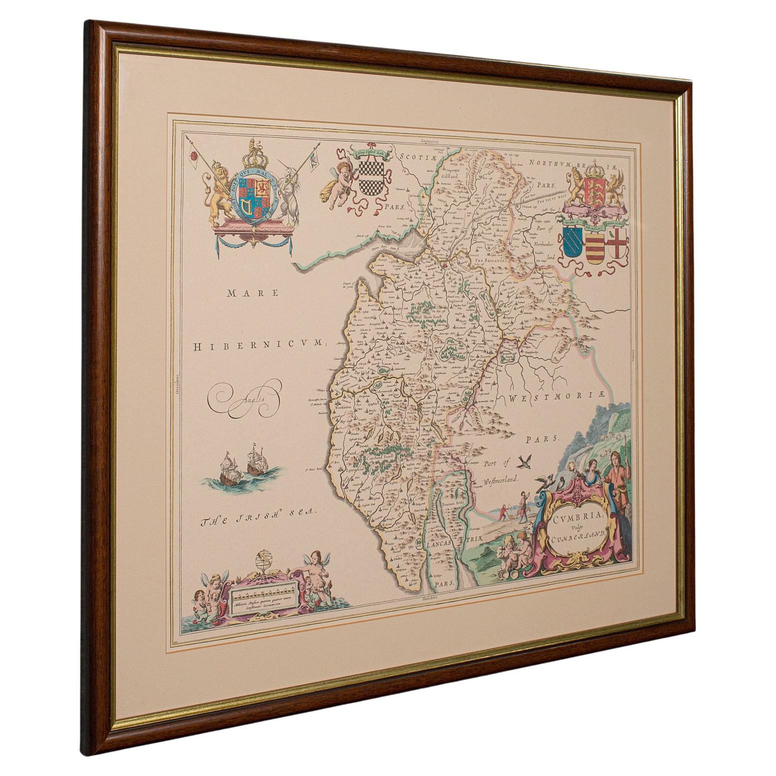
- Antique Lithography Map, Cumbria, English, Framed Cartography Interest, GeorgianLocated in Hele, Devon, GBThis is an antique lithography map of Cumbria. An English, framed engraving of cartographic interest, dating to the early 18th century and later. ...Category
Antique Early 18th Century British Georgian Maps
MaterialsWood
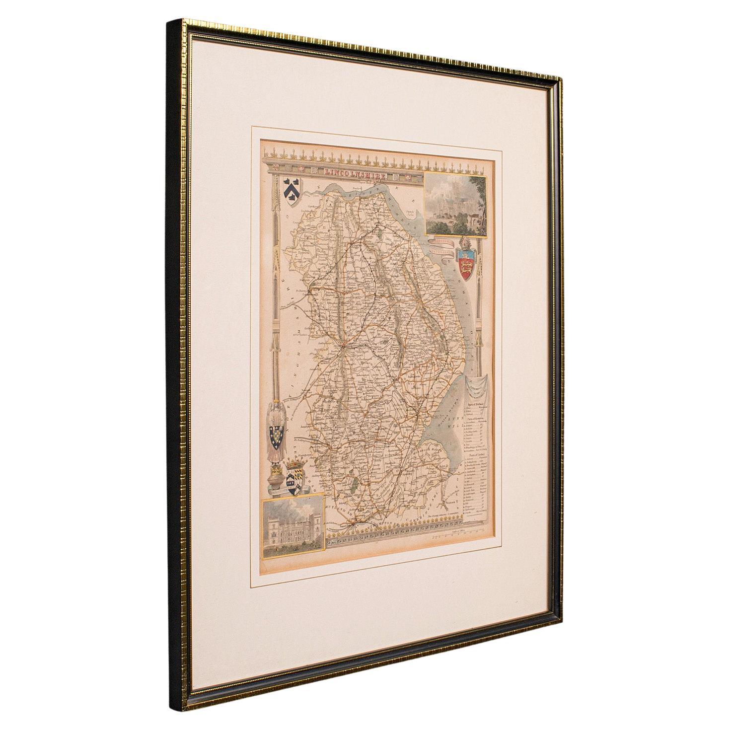
- Antique Lithography Map, Lincolnshire, English, Framed, Engraving, CartographyLocated in Hele, Devon, GBThis is an antique lithography map of Lincolnshire. An English, framed atlas engraving of cartographic interest, dating to the mid 19th century and...Category
Antique Mid-19th Century British Victorian Maps
MaterialsWood
- Antique Lithography Map, Northumberland, English, Framed, Engraving, CartographyLocated in Hele, Devon, GBThis is an antique lithography map of Northumberland. An English, framed atlas engraving of cartographic interest, dating to the mid 19th century a...Category
Antique Mid-19th Century British Victorian Maps
MaterialsWood
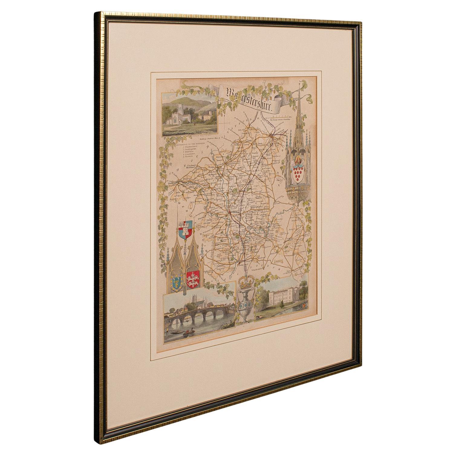
- Antique Lithography Map, Worcestershire, English, Framed Engraving, CartographyLocated in Hele, Devon, GBThis is an antique lithography map of Worcestershire. An English, framed atlas engraving of cartographic interest, dating to the early 19th centur...Category
Antique Early 19th Century British Regency Maps
MaterialsWood
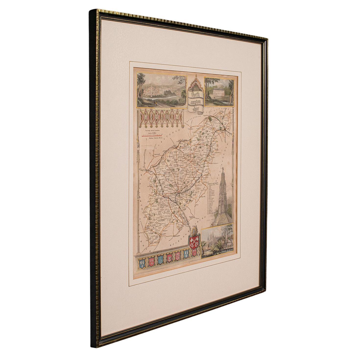
- Antique Lithography Map, Northamptonshire, English, Framed Cartography, C.1860Located in Hele, Devon, GBThis is an antique lithography map of Northamptonshire. An English, framed atlas engraving of cartographic interest, dating to the mid 19th century...Category
Antique Mid-19th Century British Victorian Maps
MaterialsWood


You May Also Like
- Large Antique County Map of Durham, EnglandLocated in Langweer, NLAntique map titled 'A Map of Durham from the best Authorities'. Original old county map of Durham, England. Engraved by John Cary. Originates from 'New ...Category
Antique Early 19th Century Maps
MaterialsPaper
- Cartographic Tapestry: Antique Map of Asia Minor, circa 1640Located in Langweer, NLTitle: "Historical Tapestry: Antique Map of Asia Minor, circa 1640" Description: This authentic antique map, created by Willem Blaeu and published in Amsterdam circa 1640, is a capt...Category
Antique Mid-17th Century Maps
MaterialsPaper
- Road Map, John Ogilby, London, Barwick, York, Chester, Darlington, Durham FramedBy John OgilbyLocated in BUNGAY, SUFFOLKThe continuation of the road from London to Barwick beginning at York and extending to Chester in ye Street. Plate ye 4th continuing 76 ½ miles. No 8. York to Burrowbridge, to Top...Category
Antique 1670s English Baroque Maps
MaterialsPaper
- Original Hand-Colored Antique County Map of Durham, England, 1804Located in Langweer, NLAntique county map of Durham first published c.1800. Villages, towns, and cities illustrated include Gateshead, South Shields, and Darlington. C...Category
Antique Early 1800s Maps
MaterialsPaper
- Cartographic Elegance of the Mughal Dominion in a Hand-Colored Antique Map, 1705Located in Langweer, NLThis original antique map titled “'T Ryk van den Grooten Mogol” by Nicolas Sanson from 1705 is an interesting historical artifact. It depicts the extent of the Mughal Empire in North...Category
Antique Early 1700s Maps
MaterialsPaper
- Map Bedfordshire General FramedLocated in BUNGAY, SUFFOLKA general map of Bedfordshire with its hundreds A scale of 5 miles in the original green mount and traditional black and gold frame. Measures: 36cm 14" high.Category
Antique 18th Century English Georgian Maps
MaterialsPaper


Recently Viewed
View AllMore Ways To Browse
Greek Map 1920
Marne Map
Antique Slovenia
Galicia Map
Antique Maps Sumatra
Santa Cruz Solomon Islands
Georg Barque
F V Hayden
Original Antique Map Of World
Map Zanzibar
Matthew Seutter On Sale
Minature Map
Vincenzo Coronelli On Sale
1681 Moses Pitt
Anguilla Map
Antique Cabbage Cutter
Antique Maps Denver
Antique Maps Washington Dc