Items Similar to Antique Map of Asia Showing Its Political Divisions, 1874

Want more images or videos?
Request additional images or videos from the seller
1 of 5
Antique Map of Asia Showing Its Political Divisions, 1874
About the Item
Antique map titled 'Map of Asia showing its Gt. Political Divisions and also the various routes of Travel between London & India, China & Japan & c'. This map covers from the Arabian Peninsula and Turkey eastward as far as Kamchatka, Japan, the Philippines and New Guinea. The map makes note of the steamship routes and mileages from London to various destinations in Asia.
Artists and Engravers: Samuel Augustus Mitchell Jr. inherited the Mitchell Company from his father in 1860. For over thrity years, the company had specialized in the production of school atlases and wall maps of America. They were one of the pioneers on engraving on steel plates.
Condition: Good, general age-related toning. Few small tears, please study image carefully.
Date: 1784
Overall size: 38.6 x 30.9 cm.
Image size:34 x 26.6 cm.
We sell original antique maps to collectors, historians, educators and interior decorators all over the world. Our collection includes a wide range of authentic antique maps from the 16th to the 20th centuries. Buying and collecting antique maps is a tradition that goes back hundreds of years. Antique maps have proved a richly rewarding investment over the past decade, thanks to a growing appreciation of their unique historical appeal. Today the decorative qualities of antique maps are widely recognized by interior designers who appreciate their beauty and design flexibility. Depending on the individual map, presentation, and context, a rare or antique map can be modern, traditional, abstract, figurative, serious or whimsical. We offer a wide range of authentic antique maps for any budget.
- Dimensions:Height: 12.17 in (30.9 cm)Width: 15.2 in (38.6 cm)Depth: 0 in (0.01 mm)
- Materials and Techniques:
- Period:
- Date of Manufacture:1874
- Condition:
- Seller Location:Langweer, NL
- Reference Number:
About the Seller
5.0
Platinum Seller
These expertly vetted sellers are 1stDibs' most experienced sellers and are rated highest by our customers.
Established in 2009
1stDibs seller since 2017
1,919 sales on 1stDibs
Typical response time: <1 hour
- ShippingRetrieving quote...Ships From: Langweer, Netherlands
- Return PolicyA return for this item may be initiated within 14 days of delivery.
More From This SellerView All
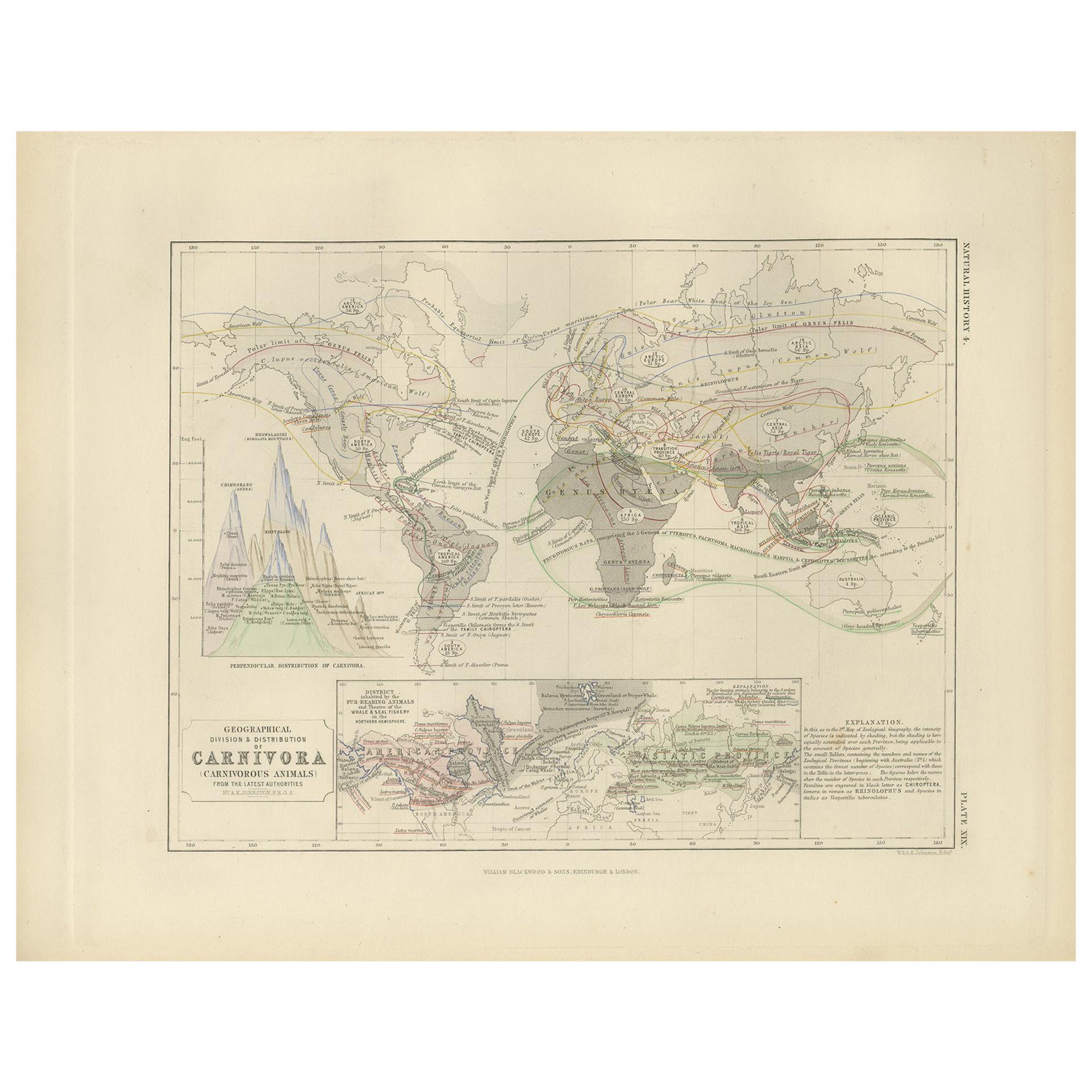
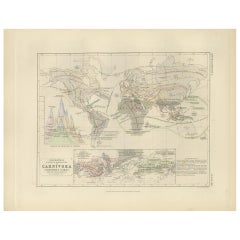
- Antique Map Showing the Division & Distribution of Carnivora by Johnston '1850'Located in Langweer, NLAntique map titled 'Geographical division and distribution of carnivorous animals'. Original antique map showing the geographical division and distribution of carnivora. This map ori...Category
Antique Mid-19th Century Maps
MaterialsPaper
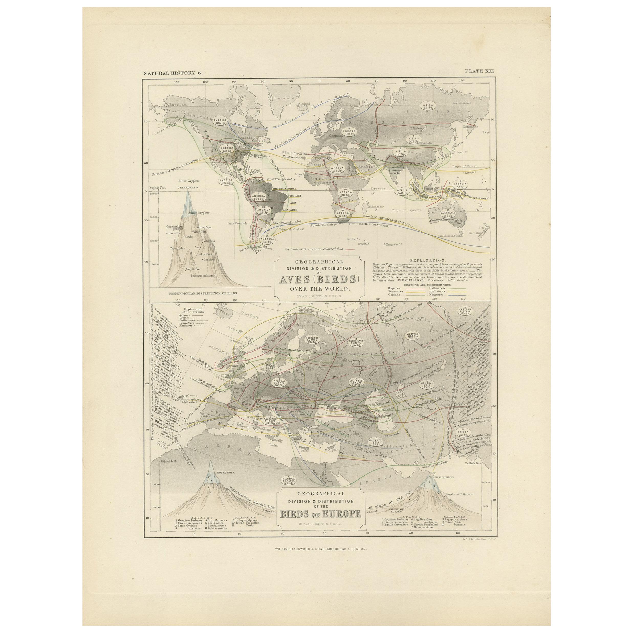
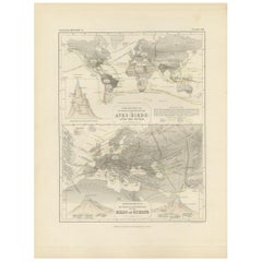
- Antique Map Showing the Division and Distribution of Birds by Johnston '1850'Located in Langweer, NLAntique map titled 'Geographical division and distribution of birds over the world and birds of Europe'. Original antique map showing the geographical division and distribution of bi...Category
Antique Mid-19th Century Maps
MaterialsPaper
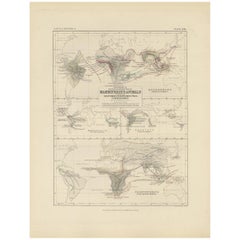
- Antique Map Showing the Division and Distribution of Mammals by Johnston '1850'Located in Langweer, NLAntique map titled 'Geographical division and distribution of mammiferous animals of the orders rodentia and ruminantia over the globe'. Original antique map showing geographical div...Category
Antique Mid-19th Century Maps
MaterialsPaper
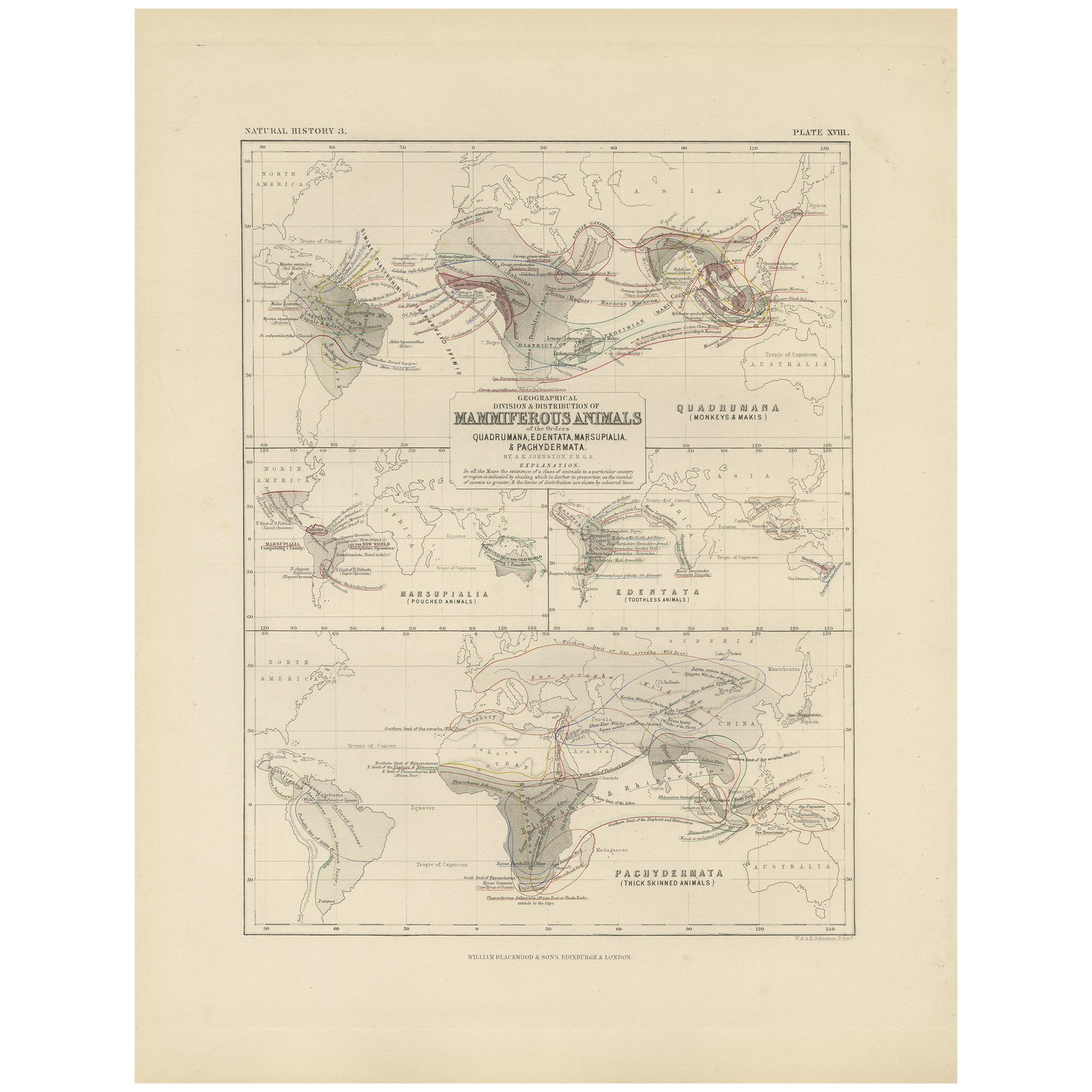
- Antique Map Showing the Division and Distribution of Mammals by Johnston '1850'Located in Langweer, NLAntique map titled 'Geographical division and distribution of mammiferous animals of the orders quadrumana, edentata, marsupialia & pachydermata'. Original antique map showing the ge...Category
Antique Mid-19th Century Maps
MaterialsPaper
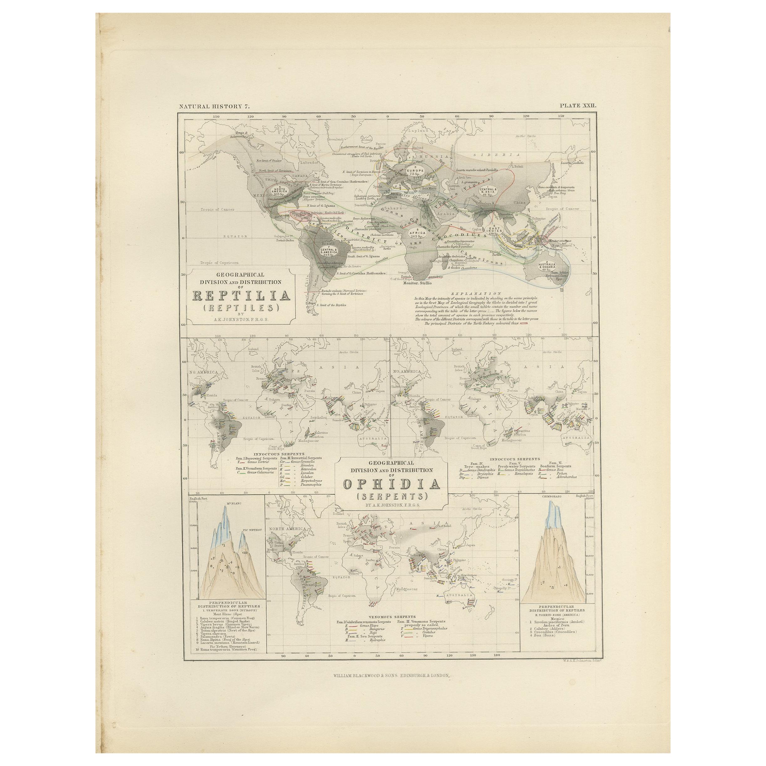
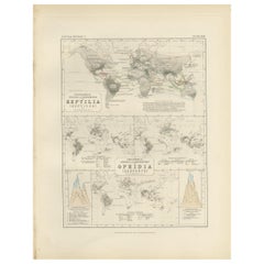
- Antique Map Showing the Division and Distribution of Reptiles by Johnston '1850'Located in Langweer, NLAntique map titled 'Geographical division and distribution of reptilia and ophidia. Original antique map showing the geographical division and distribution of reptiles and serpents. ...Category
Antique Mid-19th Century Maps
MaterialsPaper
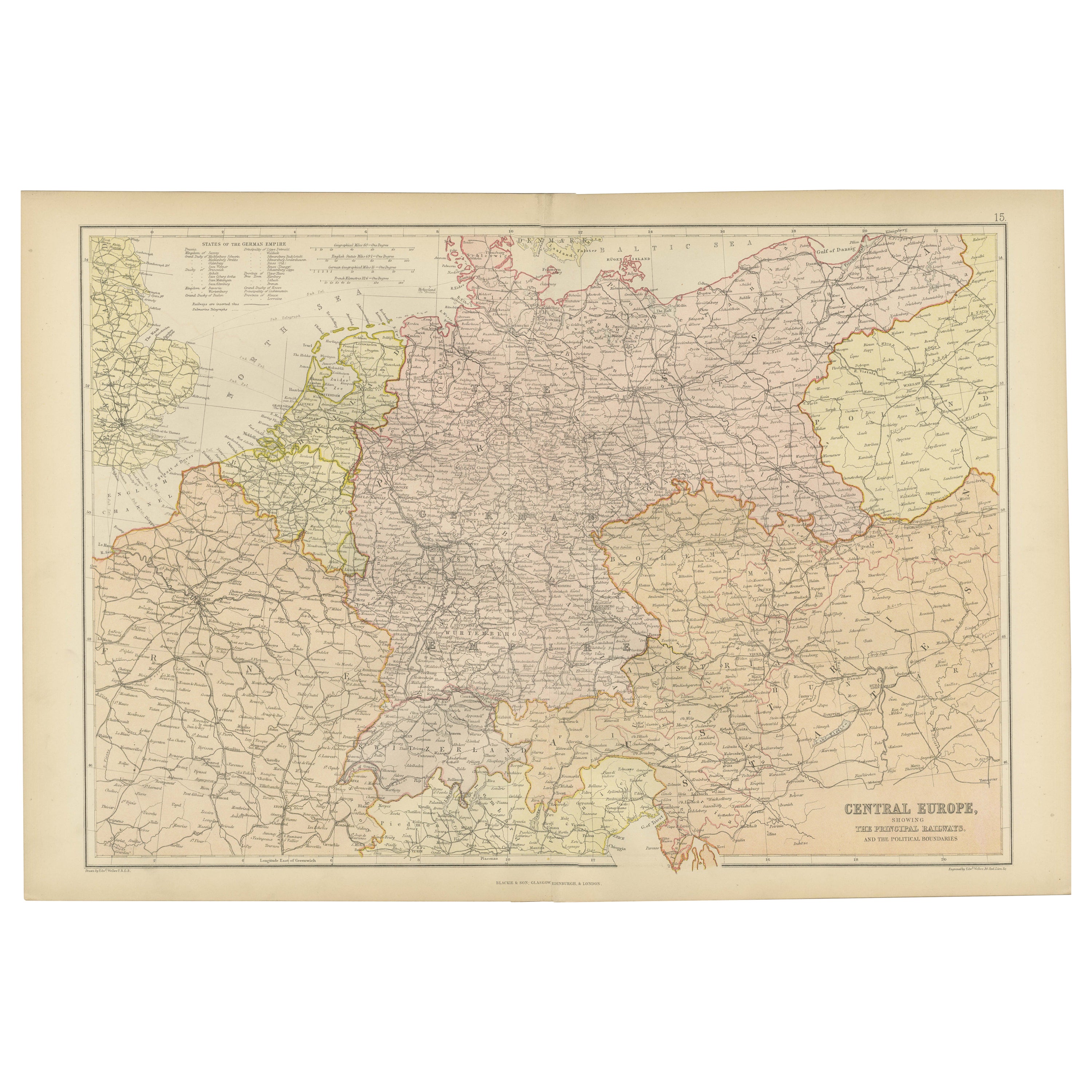
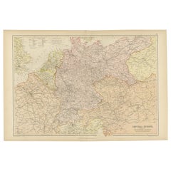
- Antique Map of Central Europe Showing The Railways and The Political BounderiesLocated in Langweer, NLExplore the Heart of Europe with the 'Central Europe' Map, Featuring Principal Railways and Political Boundaries! This map offers a captivating view of the dynamic landscapes and pol...Category
Antique 1880s Maps
MaterialsPaper

You May Also Like
- Original Antique Map of Asia. C.1780Located in St Annes, LancashireGreat map of Asia Copper-plate engraving Published C.1780 Two small worm holes to right side of map Unframed.Category
Antique Early 1800s English Georgian Maps
MaterialsPaper

- Original Antique Map of South East Asia, Arrowsmith, 1820Located in St Annes, LancashireGreat map of South East Asia Drawn under the direction of Arrowsmith Copper-plate engraving Published by Longman, Hurst, Rees, Orme and Brown, 1820 Unframed.Category
Antique 1820s English Maps
MaterialsPaper
- Large University Chart “Political Map of North America” by BaconLocated in Chillerton, Isle of WightLarge University Chart “Political Map of North America” by Bacon W&A K Johnston’s Charts of Physical Maps By G W Bacon, This is colourful Physical map ...Category
Early 20th Century American Empire Posters
MaterialsLinen
- Large University Chart “Political Map of North America” by BaconLocated in Chillerton, Isle of WightLarge University chart “Political Map of North America” by Bacon W&A K Johnston’s Charts of Political Maps by G W Bacon, This is colorful Physical ...Category
Early 20th Century American Empire Posters
MaterialsLinen
- Large Original Antique Map of Asia by Sidney Hall, 1847Located in St Annes, LancashireGreat map of Asia Drawn and engraved by Sidney Hall Steel engraving Original colour outline Published by A & C Black. 1847 Unframed Free shippingCategory
Antique 1840s Scottish Maps
MaterialsPaper
- Antique 1803 Italian Map of Asia Including China Indoneseia IndiaLocated in Amsterdam, Noord HollandAntique 1803 Italian Map of Asia Including China Indoneseia India Very nice map of Asia. 1803. Additional information: Type: Map Country of Manufacturing: Europe Period: 19th centu...Category
Antique 19th Century European Maps
MaterialsPaper


