
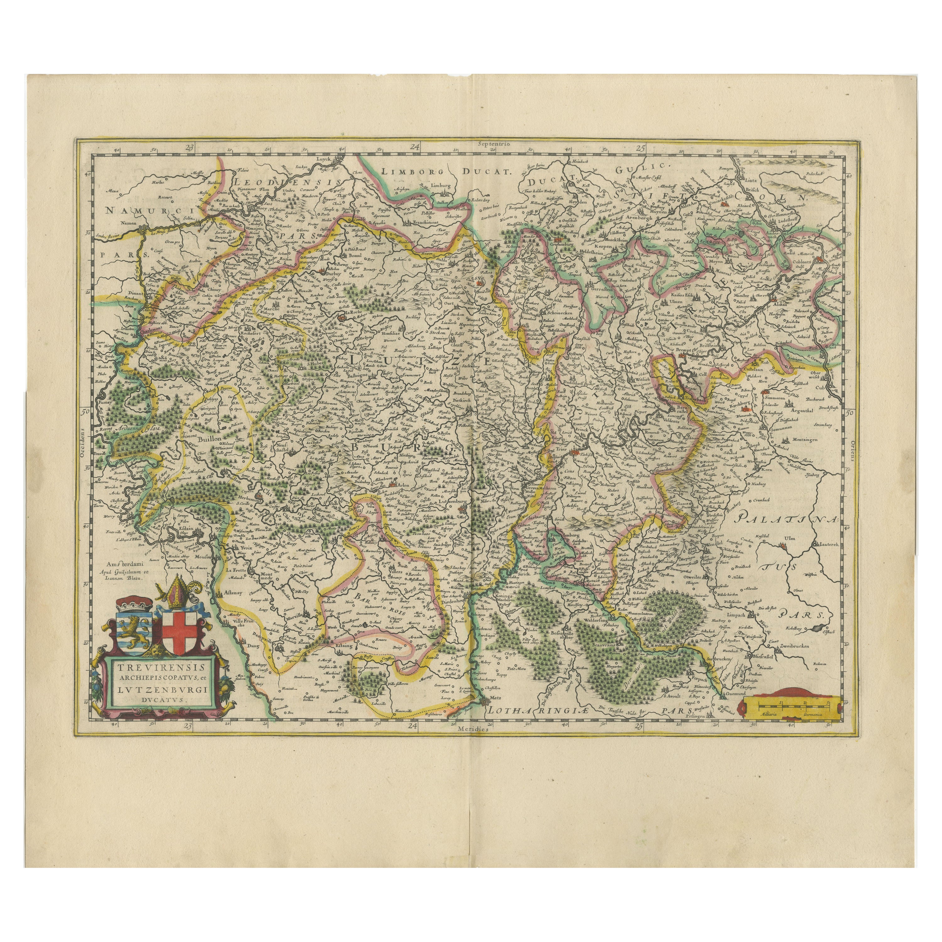
Antique Map Of Brabantia Ducantus By Bleau Circa 1640
View Similar Items


Want more images or videos?
Request additional images or videos from the seller
1 of 10
Antique Map Of Brabantia Ducantus By Bleau Circa 1640
$538.03List Price
About the Item
- Dimensions:Height: 24.81 in (63 cm)Width: 29.14 in (74 cm)Depth: 0.4 in (1 cm)
- Style:Renaissance (Of the Period)
- Materials and Techniques:
- Place of Origin:
- Period:
- Date of Manufacture:17 century
- Condition:Wear consistent with age and use.
- Seller Location:Brussels, BE
- Reference Number:1stDibs: LU4729242679172
About the Seller
4.9
Gold Seller
Premium sellers maintaining a 4.3+ rating and 24-hour response times
Established in 1988
1stDibs seller since 2019
168 sales on 1stDibs
Typical response time: 6 hours
Authenticity Guarantee
In the unlikely event there’s an issue with an item’s authenticity, contact us within 1 year for a full refund. DetailsMoney-Back Guarantee
If your item is not as described, is damaged in transit, or does not arrive, contact us within 7 days for a full refund. Details24-Hour Cancellation
You have a 24-hour grace period in which to reconsider your purchase, with no questions asked.Vetted Professional Sellers
Our world-class sellers must adhere to strict standards for service and quality, maintaining the integrity of our listings.Price-Match Guarantee
If you find that a seller listed the same item for a lower price elsewhere, we’ll match it.Trusted Global Delivery
Our best-in-class carrier network provides specialized shipping options worldwide, including custom delivery.More From This Seller
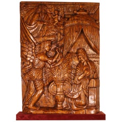
View AllAltarpiece Representing The Annunciation, North of Portugal, circa 1600
Located in Brussels, Brussels
Exceptional altarpiece representing the annunciation circa 1600, fruitwood
rare altarpiece from the North of Portugal, unique due to its large size representing the scene of the annunciation, where the Archangel Gabriel (represented on the bottom left), sent by god (represented on the top left) announces to Marie (bottom right) that she will give birth to Jesus.
Very good state of conservation, carved on three panels
Dimension: Height 1m51
Width 1m03
Very nice colour and exceptional dimensions
Restorations of use
We placed the altarpiece on a red velvet base and a Spanish occasional...
Category
Antique 17th Century Portuguese Renaissance Figurative Sculptures
Materials
Fruitwood
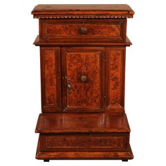
Prie-Dieu or Oratory in Walnut and Burl Walnut, circa 1600
Located in Brussels, Brussels
Elegant oratory or prieu dieu (prayer Kneeler) in walnut and burr walnut from northern Italy circa 1600
Very beautiful Italian Renaissance furniture...
Category
Antique 16th Century Italian Renaissance Religious Items
Materials
Walnut
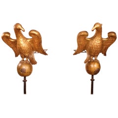
Pair of Eagles 16th Century from North Italy Church Lectern
Located in Brussels, Brussels
Exceptional pair of aigles of the 16th century of Italy
Superbe pair of wooden sculpted aigles from the Italian Renaissance. Very Fine and delicate sculpture
The pair of eagles se...
Category
Antique 16th Century Italian Renaissance Animal Sculptures
Materials
Giltwood
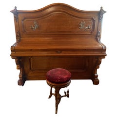
Piano Sponnagel Circa 1900 With Its Seat
Located in Brussels, Brussels
Sponnagel piano circa 1900 with its seat
Very beautiful work of sculpture and beautiful work of wooden marquetry
Very beautiful patina and in very good condition
The piano is in wo...
Category
Antique Late 19th Century Polish Aesthetic Movement Musical Instruments
Materials
Wood
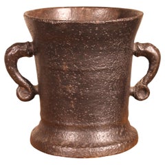
16th Century Cast Iron Mortar
Located in Brussels, Brussels
16th century cast iron mortar with two very beautiful handles
Beautiful original object with a great patina and in very good condition.
Category
Antique 16th Century French Renaissance Scientific Instruments
Materials
Iron
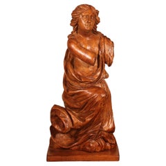
16th Century Walnut Sculptures from Germany
Located in Brussels, Brussels
Very elegant sculpture reprenting a Putti (angel) from the German renaissance period -16 century
Rare sculpture in walnut of great quality with a very beau...
Category
Antique 16th Century German Renaissance Figurative Sculptures
Materials
Walnut
$4,304 Sale Price
20% Off
You May Also Like
Antique Map of the Region of Blois by Janssonius, 'circa 1640'
By Johannes Janssonius
Located in Langweer, NL
Antique map titled 'Description du Blaisois'. Old map of the region of Blois, France. It shows the city of Blois, Amboise, the Loire River and more. Published by J. Janssonius, circa...
Category
Antique Mid-17th Century Maps
Materials
Paper

$388 Sale Price
35% Off
Antique Map of the Region of Bourbonnais by Janssonius, circa 1640
Located in Langweer, NL
Antique map titled 'Bourbonois - Borbonium Ducatus'. Old map of the former region of Bourbonnais, France. It includes the cities of Bourbon, Moulins, Charenton, Brulles, Varennes and...
Category
Antique Mid-17th Century Maps
Materials
Paper

$478 Sale Price
20% Off
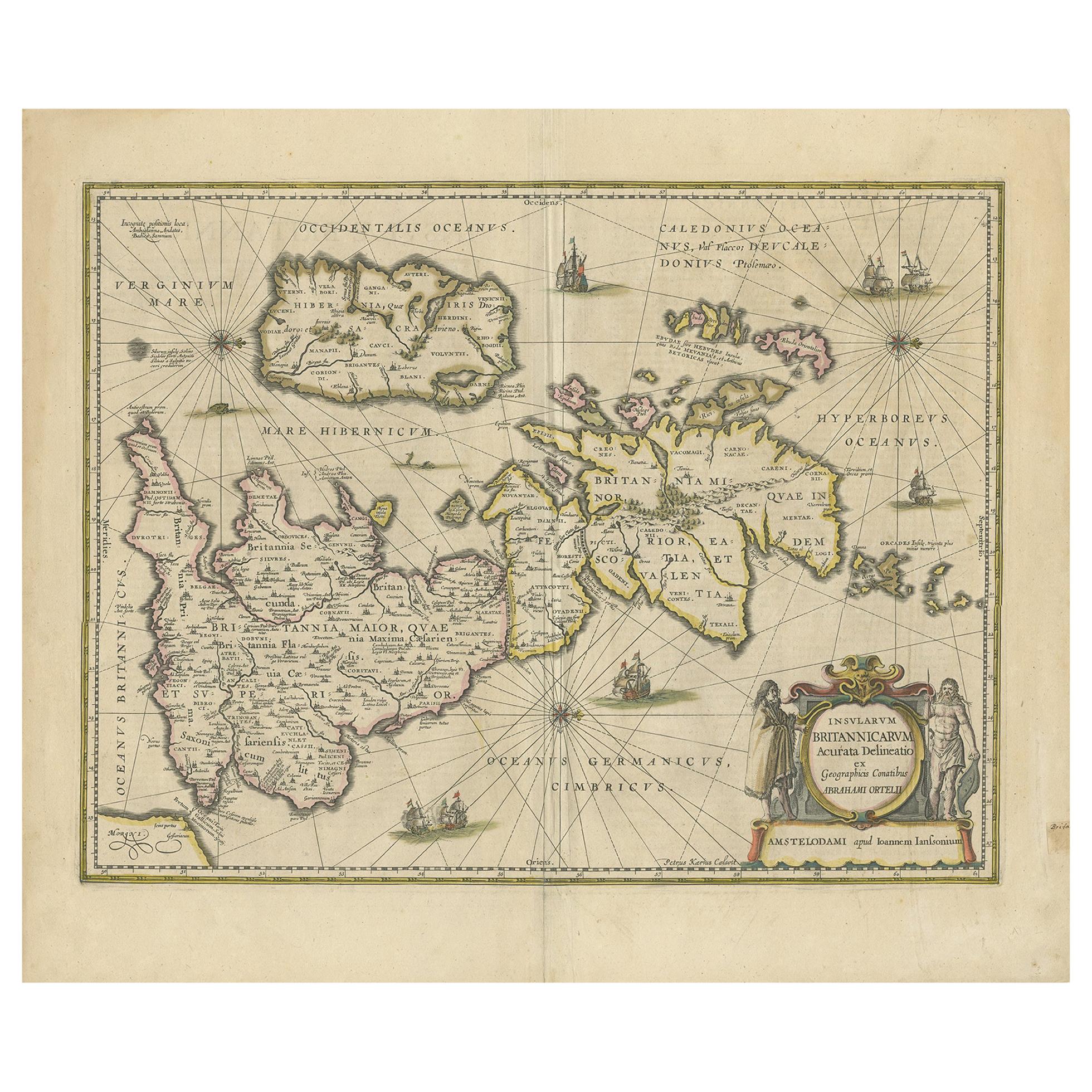
Antique Map of the Ancient British Isles by Janssonius 'circa 1640'
Located in Langweer, NL
Antique map titled 'Insularum Britannicarum Acurata Delineatio'. Original antique map of the ancient British Isles. England and Wales are labelled as B...
Category
Antique Mid-17th Century Maps
Materials
Paper

$908 Sale Price
20% Off
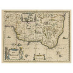
Antique Engraving of Blaeu's first Map of Brazil, Circa 1640
By Willem Blaeu
Located in Langweer, NL
Antique map titled 'Novus Brasiliae Typus'. Fine old color example of Blaeu's first map of Brazil, with north oriented to the right. Includes inset map of Baya de todos Santos, elaborate cartouche, 2 compass roses and richly embellished vignettes of native Brazilian life and animals.
The interior of the map includes vignettes of indigenous animals and native scenes, including cannibalism. Inset within a decorative border is a small map of "Baya de todos Sanctos". In the sea are monsters, a galleon and two compass roses. The large title cartouche features a male and female Brazilian, both of whom are shown naked.
Willem Janszoon Blaeu (1571-1638) was a prominent Dutch geographer and publisher. Born the son of a herring merchant, Blaeu chose not fish but mathematics and astronomy for his focus. He studied with the famous Danish astronomer Tycho Brahe...
Category
Antique Mid-17th Century Dutch Maps
Materials
Paper
Antique Map of the Hainaut and Namur Region by Janssonius, 'circa 1640'
By Johannes Janssonius
Located in Langweer, NL
Antique map titled 'Comitatuum Hannoniae et Namurci Descriptio'. Old map of the region of Hainaut and Namur, France. Published by J. Janssonius, circa 1640.
Category
Antique Mid-17th Century Maps
Materials
Paper

$478 Sale Price
20% Off
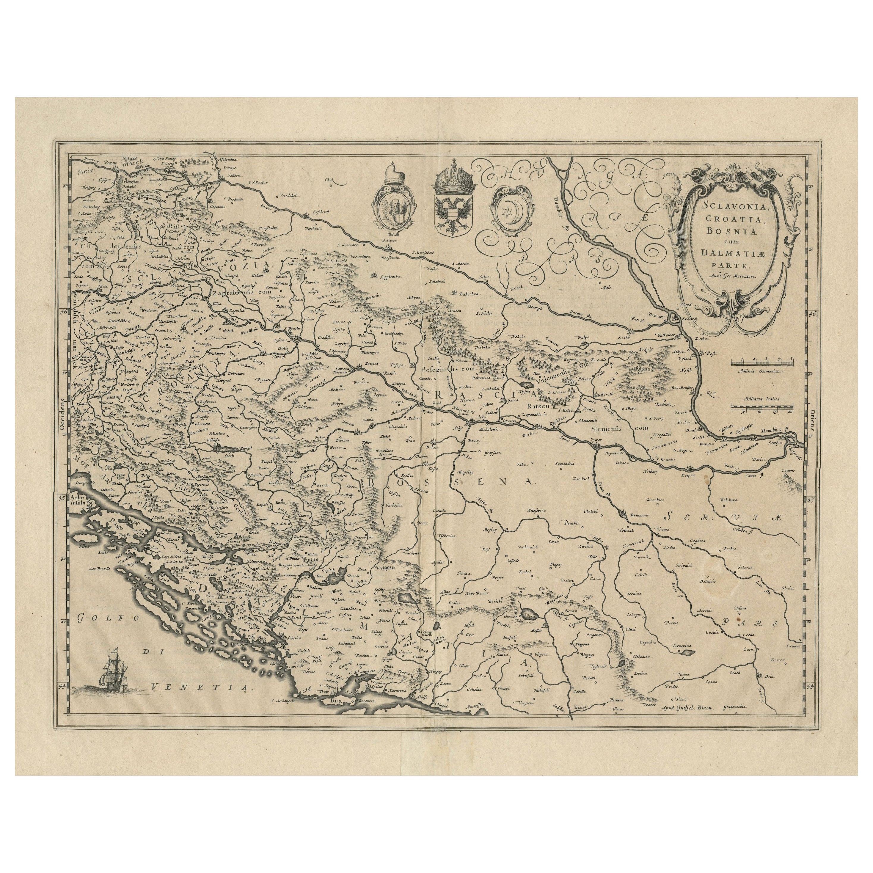
Antique Map of Slavonia, Croatia, Bosnia and Dalmatia by Janssonius, circa 1640
Located in Langweer, NL
Antique Map of Slavonia, Croatia, Bosnia and Dalmatia by Janssonius, circa 1640
This elegant and detailed map titled Sclavonia, Croatia, Bosnia cum Dalmatiae Parte was published by ...
Category
Antique 17th Century Dutch Maps
Materials
Paper

Recently Viewed
View AllMore Ways To Browse
China Silk Rug
Early English Silver
Italian Carved Dining Set
Antique Silver Basket
Black Crystal Glasses
Baker Furniture By
Oak Library
T Chair
Antique Italian Chairs
Antique Victorian Dining Tables
Veneer Dining Tables
Antique Brass And Copper
Antique English Country Furniture
Antique Russian Rugs
Beni Ourain Rugs
Glass Top Wood Base Coffee Tables
Inlaid Wood Frame
Large Antique Tapestry Tapestries