
Antique Map of the Empire of Alexander the Great by Lapie, 1842
View Similar Items


Want more images or videos?
Request additional images or videos from the seller
1 of 5
Antique Map of the Empire of Alexander the Great by Lapie, 1842
About the Item
- Dimensions:Height: 19.89 in (50.5 cm)Width: 26.78 in (68 cm)Depth: 0.02 in (0.5 mm)
- Materials and Techniques:
- Period:
- Date of Manufacture:1842
- Condition:General age-related toning, original folding line. Blank verso, please study images carefully.
- Seller Location:Langweer, NL
- Reference Number:Seller: BG-12338-41stDibs: LU3054319603452
About the Seller
5.0
Platinum Seller
These expertly vetted sellers are 1stDibs' most experienced sellers and are rated highest by our customers.
Established in 2009
1stDibs seller since 2017
1,933 sales on 1stDibs
More From This SellerView All
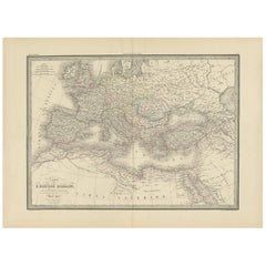
- Antique Map of the Roman Empire by Lapie, 1842Located in Langweer, NLAntique map titled 'Carte de l'Empire Romain'. Map of the Roman Empire. This map originates from 'Atlas universel de géographie ancienne et moderne (..)' by Pierre M. Lapie and Alexa...Category
Antique Mid-19th Century Maps
MaterialsPaper
- Antique Map of the Antilles by Lapie, '1842'Located in Langweer, NLAntique map titled 'Carte des Antilles du Golfe du Méxique'. Map of the Antilles. This map originates from 'Atlas universel de géographie ancienne et moderne (..)' by Pierre M. Lapie...Category
Antique Mid-19th Century Maps
MaterialsPaper
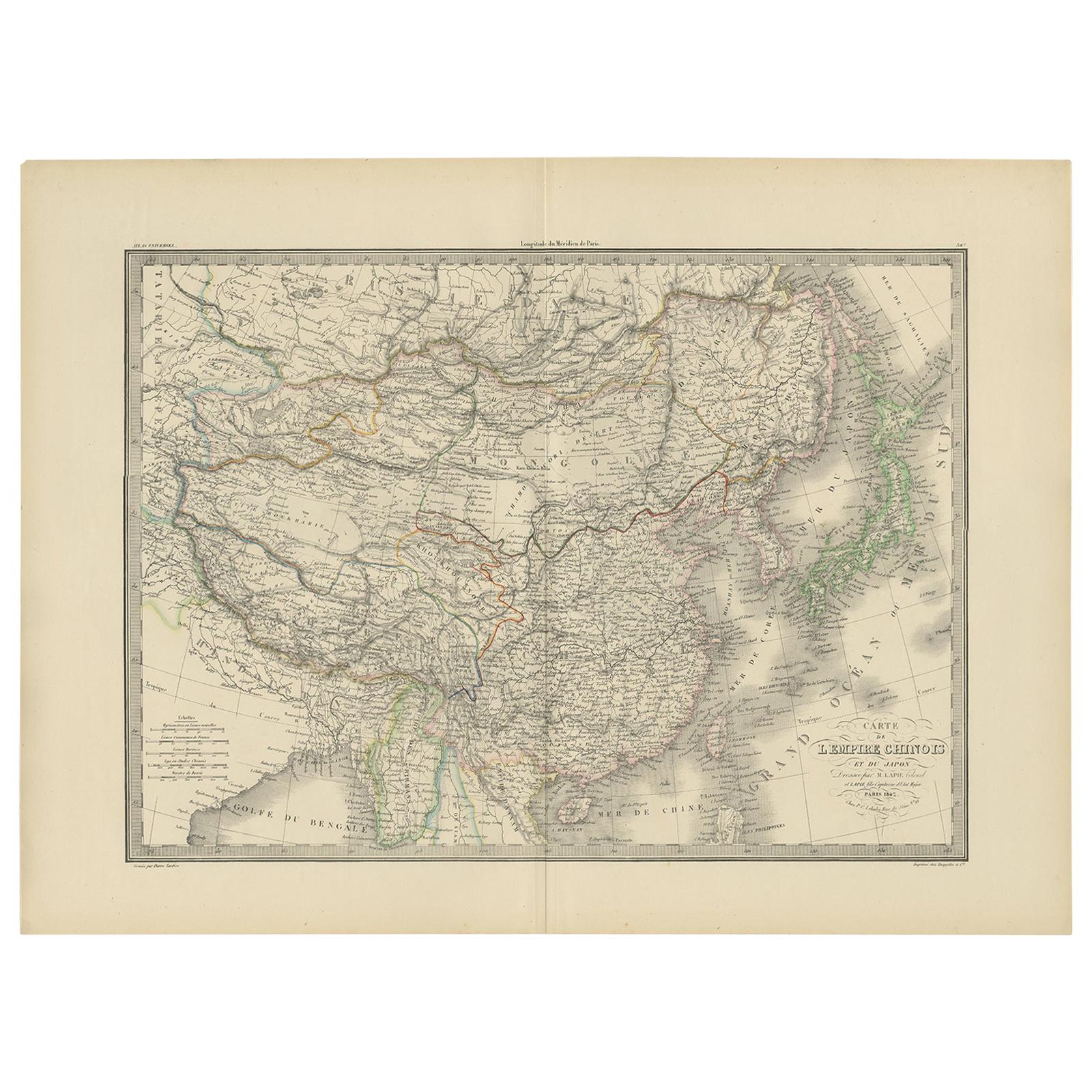
- Antique Map of the Chinese Empire and Japan by Lapie, 1842Located in Langweer, NLAntique map titled 'Carte de L'Empire Chinois et du Japon'. Map of the Chinese Empire (China) and Japan. This map originates from 'Atlas universel de géographie ancienne et moderne (...Category
Antique Mid-19th Century Maps
MaterialsPaper
- Antique Map of Switzerland by Lapie, 1842Located in Langweer, NLAntique map titled 'Carte de la Suisse ou Helvetie'. Map of Switzerland. This map originates from 'Atlas universel de géographie ancienne et moderne...Category
Antique Mid-19th Century Maps
MaterialsPaper
- Antique Map of Italy by Lapie, 1842Located in Langweer, NLAntique map titled 'Carte de l'Italie Ancienne'. Map of Italy. This map originates from 'Atlas universel de géographie ancienne et moderne (..)' by Pierre...Category
Antique Mid-19th Century Maps
MaterialsPaper
- Antique Map of Germany by Lapie, 1842Located in Langweer, NLAntique map titled 'Carte de la Germanie Ancienne'. Map of Germany. This map originates from 'Atlas universel de géographie ancienne et moderne (..)' by...Category
Antique Mid-19th Century Maps
MaterialsPaper


You May Also Like
- Map of the Holy Land "Carte de la Syrie et de l'Egypte" by Pierre M. LapieBy Pierre M. LapieLocated in Alamo, CAAn early 19th century map of ancient Syria and Egypt entitled "Carte de la Syrie et de l'Egypte anciennes/dressée par M. Lapie, Colonel d'Etat Major, et...Category
Antique Early 19th Century French Maps
MaterialsPaper
- Original Antique Map of The World by Thomas Clerk, 1817Located in St Annes, LancashireGreat map of The Eastern and Western Hemispheres On 2 sheets Copper-plate engraving Drawn and engraved by Thomas Clerk, Edinburgh. Published by Mackenzie And Dent, 1817 ...Category
Antique 1810s English Maps
MaterialsPaper
- England, Scotland & Ireland: A Hand Colored Map of Great Britain by TirionBy Isaak TirionLocated in Alamo, CAThis is a hand-colored double page copperplate map of Great Britain entitled "Nieuwe Kaart van de Eilanden van Groot Brittannien Behelzende de Kon...Category
Antique Mid-18th Century Dutch Maps
MaterialsPaper
- Original Antique Map of The Netherlands, Engraved by Barlow, Dated 1807Located in St Annes, LancashireGreat map of Netherlands Copper-plate engraving by Barlow Published by Brightly & Kinnersly, Bungay, Suffolk. Dated 1807 Unframed.Category
Antique Early 1800s English Maps
MaterialsPaper
- Map of the Republic of GenoaLocated in New York, NYFramed antique hand-coloured map of the Republic of Genoa including the duchies of Mantua, Modena, and Parma. Europe, late 18th century. Dimension: 25...Category
Antique Late 18th Century European Maps
- Antique Map of Italy by Andriveau-Goujon, 1843By Andriveau-GoujonLocated in New York, NYAntique Map of Italy by Andriveau-Goujon, 1843. Map of Italy in two parts by Andriveau-Goujon for the Library of Prince Carini at Palazzo Carini i...Category
Antique 1840s French Maps
MaterialsLinen, Paper
 $3,350 / set


Recently Viewed
View AllMore Ways To Browse
Carte Ancienne
Map Of Alexander The Great
Original Antique World Map
Map Of United States
Antique German Collectible
Authentic Antique Maps
The United States Map
Map France
Map Of The United States
Antiques From Scotland
Antique French Maps
Antique French Map
Antique Maps France
Antique Map France
France Antique Map
Map Of Provence
World Map Rare
Map Plate