Items Similar to Antique Map of the German Empire by De Leth, 1749


Want more images or videos?
Request additional images or videos from the seller
1 of 5
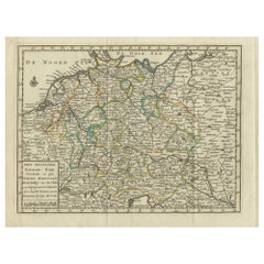
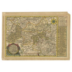
Antique Map of the German Empire by De Leth, 1749
About the Item
Antique map Germany titled 'L'Empire d'Allemagne divisé en ses dix cercles et Autres Estats'. Detailed map of the German Empire divided in the ten regions. This antique map originates from 'Nieuwe Astronomische Geographische en Historische Atlas (..)' by J.R. de Missy.
Artists and Engravers: Author: Jean Rousset de Missy (b. Laon, 1686-1762) was a French Huguenot writer, living from early in life in the Netherlands. He was a renowned historian and author on international law and a prolific journalist. Publisher: Hendrik de Leth (Amsterdam, 1703-1766). De Leth was a printmaker and draughtsman of landscapes, active in Amsterdam.
Condition: Very good, original/contemporary hand coloring. Please study image carefully.
Date: 1749
Overall size: 23.5 x 19 cm.
Image size: 21.5 x 15.5 cm.
We sell original antique maps to collectors, historians, educators and interior decorators all over the world. Our collection includes a wide range of authentic antique maps from the 16th to the 20th centuries. Buying and collecting antique maps is a tradition that goes back hundreds of years. Antique maps have proved a richly rewarding investment over the past decade, thanks to a growing appreciation of their unique historical appeal. Today the decorative qualities of antique maps are widely recognized by interior designers who appreciate their beauty and design flexibility. Depending on the individual map, presentation, and context, a rare or antique map can be modern, traditional, abstract, figurative, serious or whimsical. We offer a wide range of authentic antique maps for any budget
- Dimensions:Height: 7.49 in (19 cm)Width: 9.26 in (23.5 cm)Depth: 0 in (0.01 mm)
- Materials and Techniques:
- Period:
- Date of Manufacture:1749
- Condition:
- Seller Location:Langweer, NL
- Reference Number:
About the Seller
5.0
Platinum Seller
These expertly vetted sellers are 1stDibs' most experienced sellers and are rated highest by our customers.
Established in 2009
1stDibs seller since 2017
1,932 sales on 1stDibs
Typical response time: <1 hour
- ShippingRetrieving quote...Ships From: Langweer, Netherlands
- Return PolicyA return for this item may be initiated within 14 days of delivery.
More From This SellerView All
- Antique Map of the Region of Gommern in Germany, 1749By SchreiberLocated in Langweer, NLAntique map titled 'Das Amt Gommern und die Graffschafft Barby (..)'. Map of the region of Gommern, Germany. This map originates from 'Atlas Selectus von allen Konigreichen und Lande...Category
Antique 18th Century Maps
MaterialsPaper
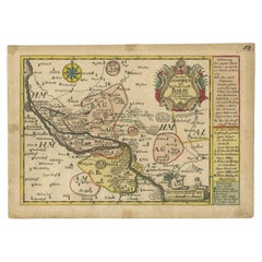
- Antique Map of the Region of Zeitz in Germany, 1749By SchreiberLocated in Langweer, NLAntique map titled 'Das Stifft Zeitz (..)'. Map of the region of Zeitz, Germany. Zeitz is a town in the Burgenlandkreis district, in Saxony-Anhalt, Germany. It is situated on the riv...Category
Antique 18th Century Maps
MaterialsPaper
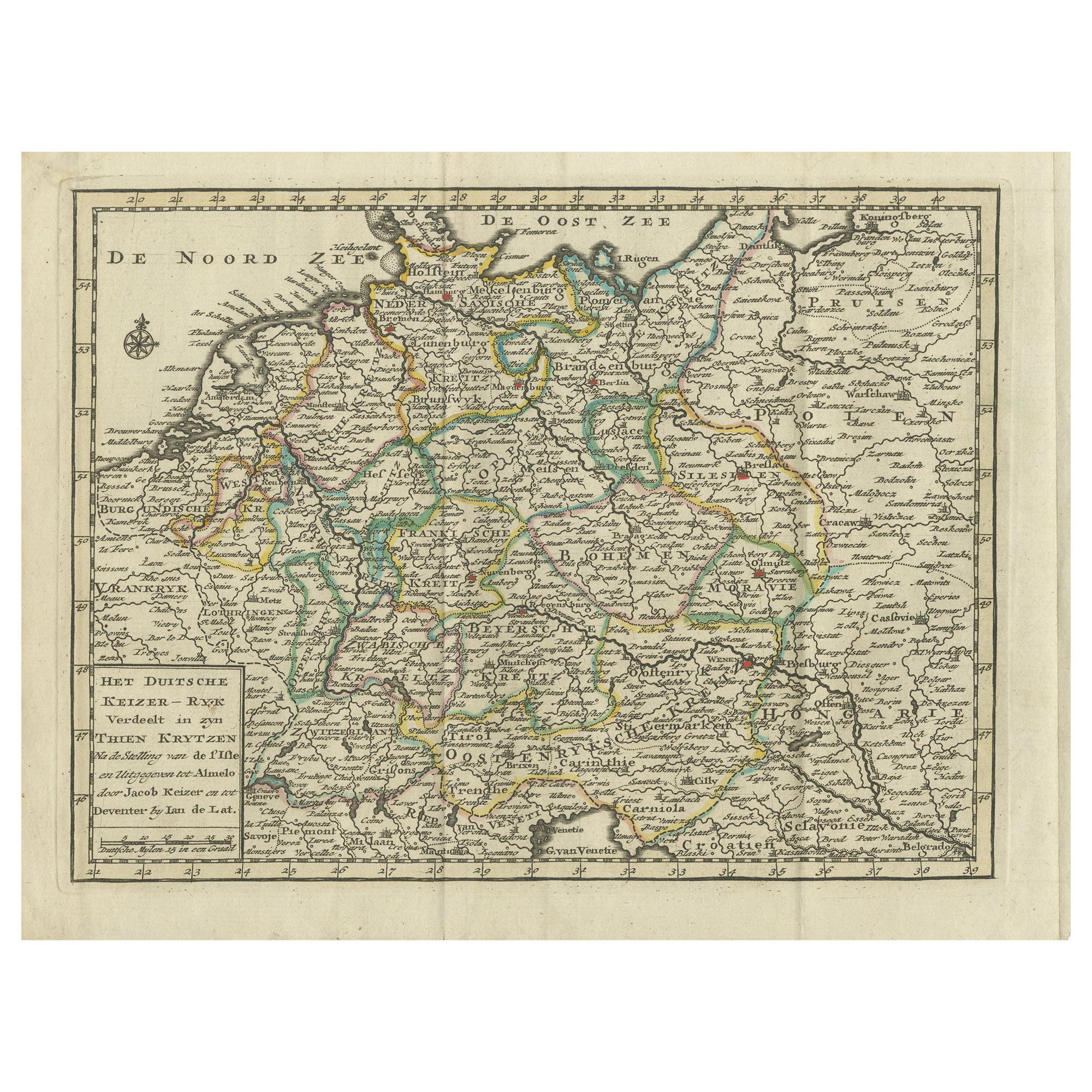
- Antique Map of the German Empire by Keizer & de Lat, 1788Located in Langweer, NLAntique map titled 'Het Duitsche Keizer-Ryk (..)'. Uncommon original antique map of the German Empire. This map originates from 'Nieuwe Natuur- Geschied- en Handelkundige Zak- en Rei...Category
Antique Late 18th Century Maps
MaterialsPaper
- Antique Map of the Philippines by Anson '1749'Located in Langweer, NLAntique map titled 'Carte du Canal des Iles Philippines - Kaart van het Kanaal in de Filippynsche Eilanden'. Large detailed chart of the islands of the Philippines. One of the most detailed charts of the Philippines of the era. Shows Islands, bays, reefs, soundings tracks of the Manila Galleon route, etc. Includes a large compass...Category
Antique Mid-18th Century Maps
MaterialsPaper
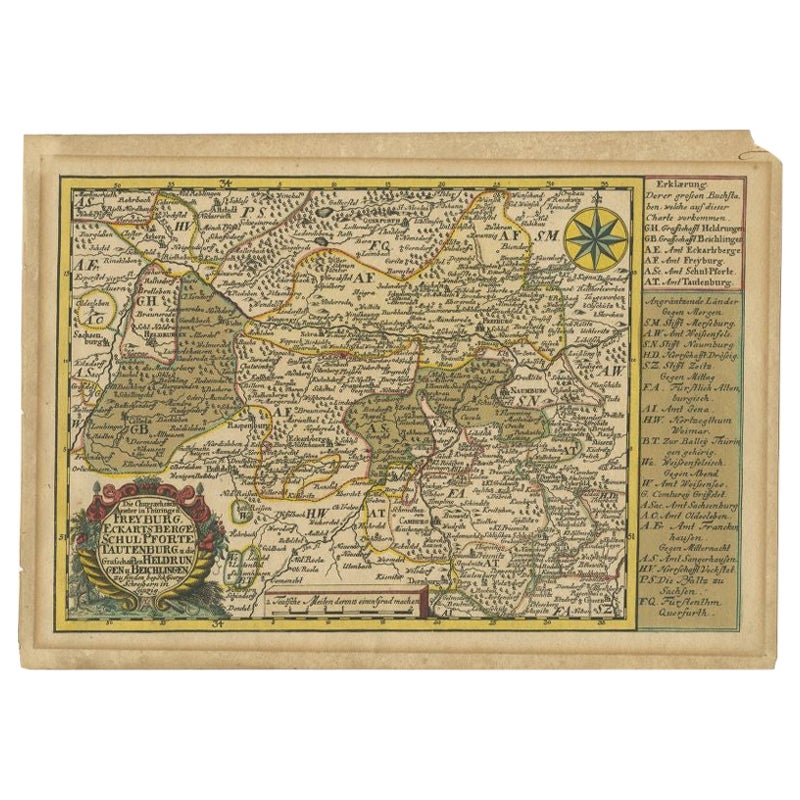
- Rare Antique Map of the Region of Freyburg in Germany, 1749By SchreiberLocated in Langweer, NLAntique map titled 'Die Chursaechsisch Aemter in Thüringen Freyburg (..)'. Map of the region of Freyburg, Germany. This map originates from 'Atlas Selectus von allen...Category
Antique 18th Century Maps
MaterialsPaper
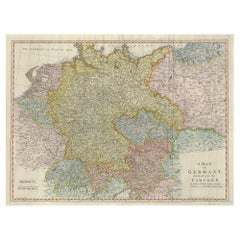
- Large Antique Map of the German EmpireLocated in Langweer, NLAntique map titled 'A Map of Germany (..)'. Large antique map of the German Empire, highly detailed. Engraved by T. Kitchin. Published J. Blair, cir...Category
Antique Late 18th Century Maps
MaterialsPaper


You May Also Like
- Antique Carte de L'Inde Myanmar, Malaysia Vietnam Map of Asia the Chinese EmpireLocated in Amsterdam, Noord HollandAntique Carte de L'Inde Myanmar, Malaysia Vietnam Map of Asia the Chinese Empire Very nice map of Asia. Additional information: Type: Map Country of Man...Category
Antique 18th Century European Maps
MaterialsPaper
- Germany West of the Rhine: A Hand-colored 18th Century Map by de WitBy Frederick de WitLocated in Alamo, CAThis original 18th century hand-colored map of the county of Moers, Germany entitled "Illustrissimo Celsissmo Principi GUILIELMO HENRICO D.G. Arausionum Principi Domino suo Clementis...Category
Antique Early 18th Century Dutch Maps
MaterialsPaper
- Map Kyle Carrick Aireshire Thomas Kitchen 1749By Thomas KitchinLocated in BUNGAY, SUFFOLKA Map of Kyle & Carrick Aireshire Thomas Kitchen 1749 In original black and gold frame Just purchased more information to follow MAKER Thomas Kitchin (1718-1784) English engrave...Category
Antique 18th Century English Georgian Maps
MaterialsPaper
- 1861 Topographical Map of the District of Columbia, by Boschke, Antique MapLocated in Colorado Springs, COPresented is an original map of Albert Boschke's extremely sought-after "Topographical Map of the District of Columbia Surveyed in the Years 1856 ...Category
Antique 1860s American Historical Memorabilia
MaterialsPaper
- Super Rare Antique French Map of Chine and the Chinese Empire, 1780Located in Amsterdam, Noord HollandSuper Rare Antique French Map of Chine and the Chinese Empire, 1780 Very nice map of Asia. 1780 Made by Bonne. Additional information: Type: Map ...Category
Antique 18th Century European Maps
MaterialsPaper
- East German MapBy VEB Hermann HaackLocated in Baltimore, MDA brilliantly colourful map of the Leipzig, Karl Marx Stadt and Dresden area in the former German Democratic Republic by VEB Hermann Haack of Gotha.Category
Vintage 1970s German Maps


Recently Viewed
View AllMore Ways To Browse
For The Empire
German Empire Furniture
German Empire
Antique French Divider
Historical Maps Germany
A D Allemagne
Antique Map German Empire
Premier Antiques
Compass 18th Century
18th Century Compass
Antique Furniture Building Plans
Antique Spain Map
Large City Maps
Spain Antique Map
Military Map
Antique Maps Of Spain
Antique Map Of Spain
Antique Japanese Map