Items Similar to Antique Map of the Island of Funen by Kaerius, 1628


Want more images or videos?
Request additional images or videos from the seller
1 of 5
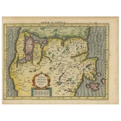
Antique Map of the Island of Funen by Kaerius, 1628
About the Item
Antique map titled 'Fionia'. Copper engraved map of the Island of Funen (Denmark) by P. Kaerius. Funen is Denmark's second largest island, between the Jutland peninsula, and the capital island of Zealand. This map originates from 'Atlas Minor (..)' by G. Mercator.
- Dimensions:Height: 8.27 in (21 cm)Width: 11.23 in (28.5 cm)Depth: 0.02 in (0.5 mm)
- Materials and Techniques:
- Period:Mid-17th Century
- Date of Manufacture:1628
- Condition:General age-related toning. Minor wear, Latin text on verso. Please study image carefully.
- Seller Location:Langweer, NL
- Reference Number:
About the Seller
5.0
Platinum Seller
These expertly vetted sellers are 1stDibs' most experienced sellers and are rated highest by our customers.
Established in 2009
1stDibs seller since 2017
1,916 sales on 1stDibs
Typical response time: <1 hour
- ShippingRetrieving quote...Ships From: Langweer, Netherlands
- Return PolicyA return for this item may be initiated within 14 days of delivery.
More From This SellerView All
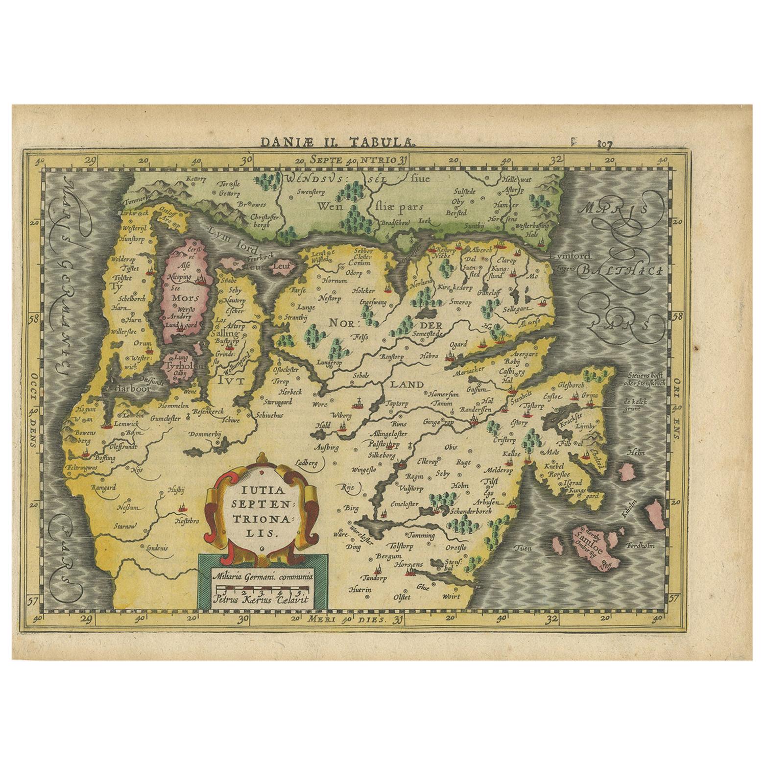
- Antique Map of Northern Jutland by Kaerius, 1628Located in Langweer, NLAntique map titled 'Iutia Septentrionalis'. Copper engraved map of Northern Jutland (Denmark) by P. Kaerius. This map originates from 'Atlas Minor (..)' by G. Mercator.Category
Antique Mid-17th Century Maps
MaterialsPaper
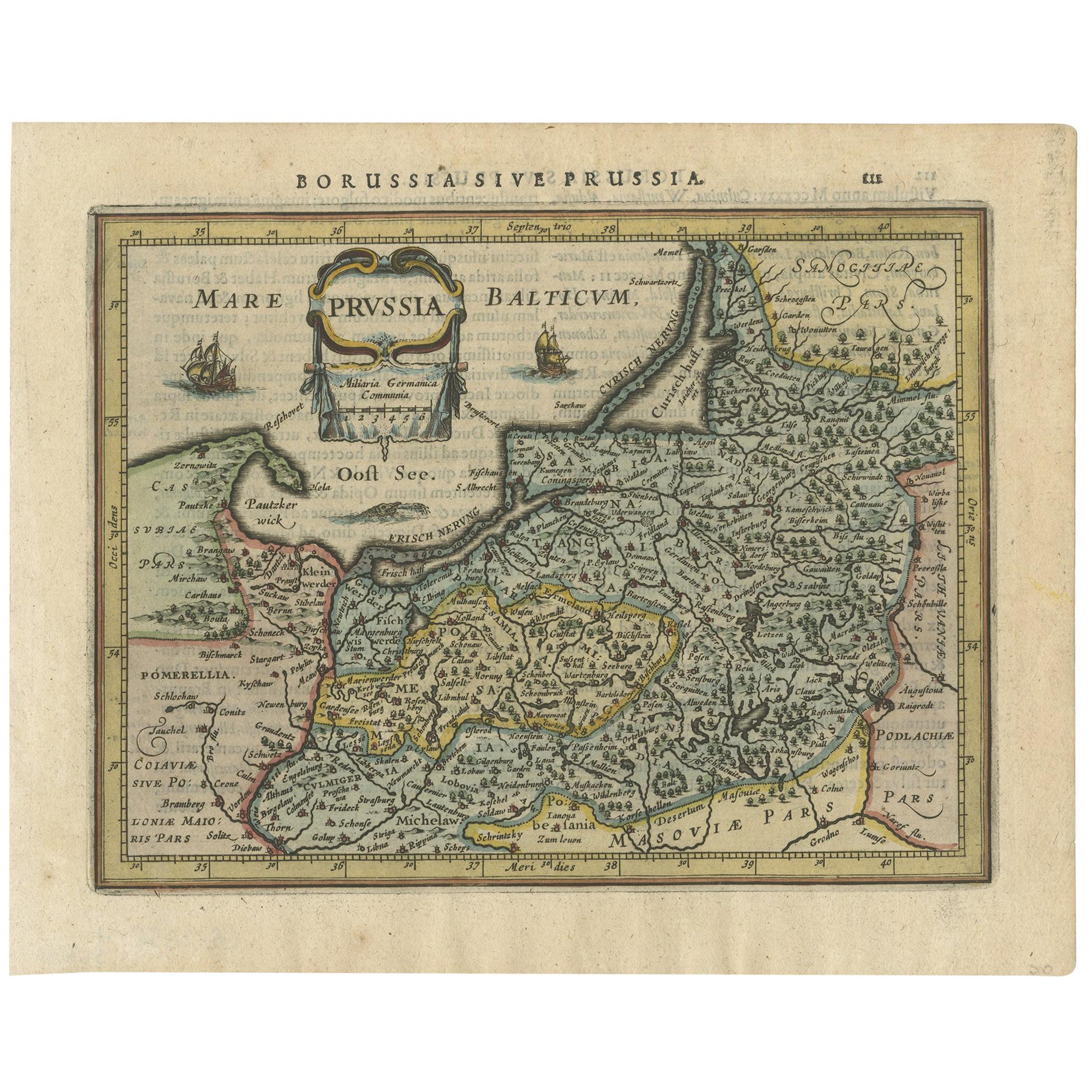
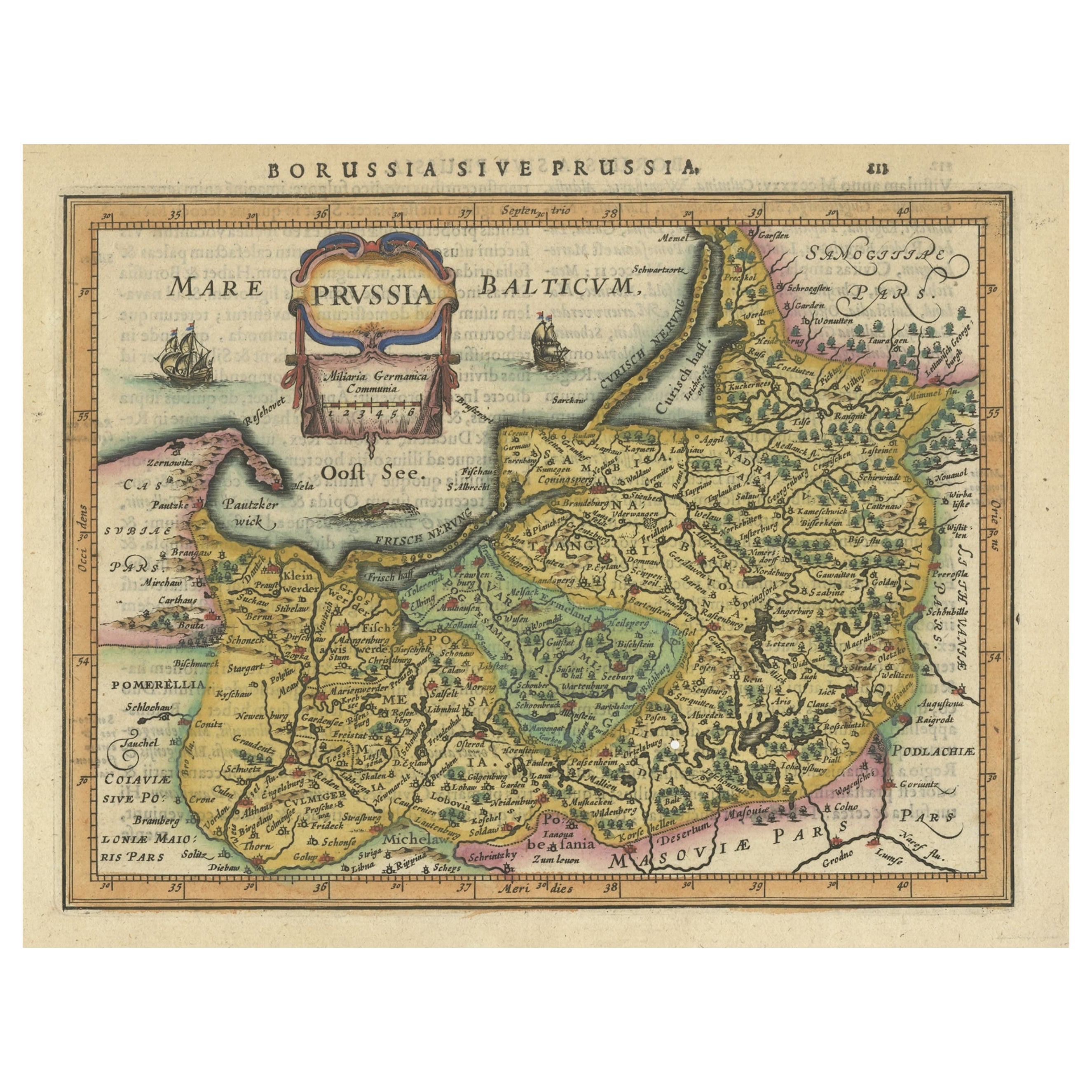
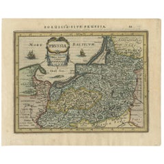
- Antique Map of Prussia by Janssonius, 1628Located in Langweer, NLAntique map titled 'Prussia'. Original antique map of Prussia, a historically prominent German state that originated in 1525 with a duchy centered on th...Category
Antique Mid-17th Century Maps
MaterialsPaper
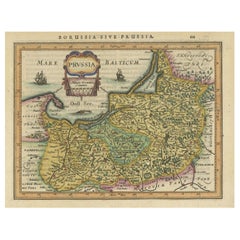
- Original Decorative Antique Map of Prussia, 1628Located in Langweer, NLAntique map titled 'Prussia'. Original antique map of Prussia, a historically prominent German state that originated in 1525 with a duchy centered on th...Category
Antique 1620s Maps
MaterialsPaper
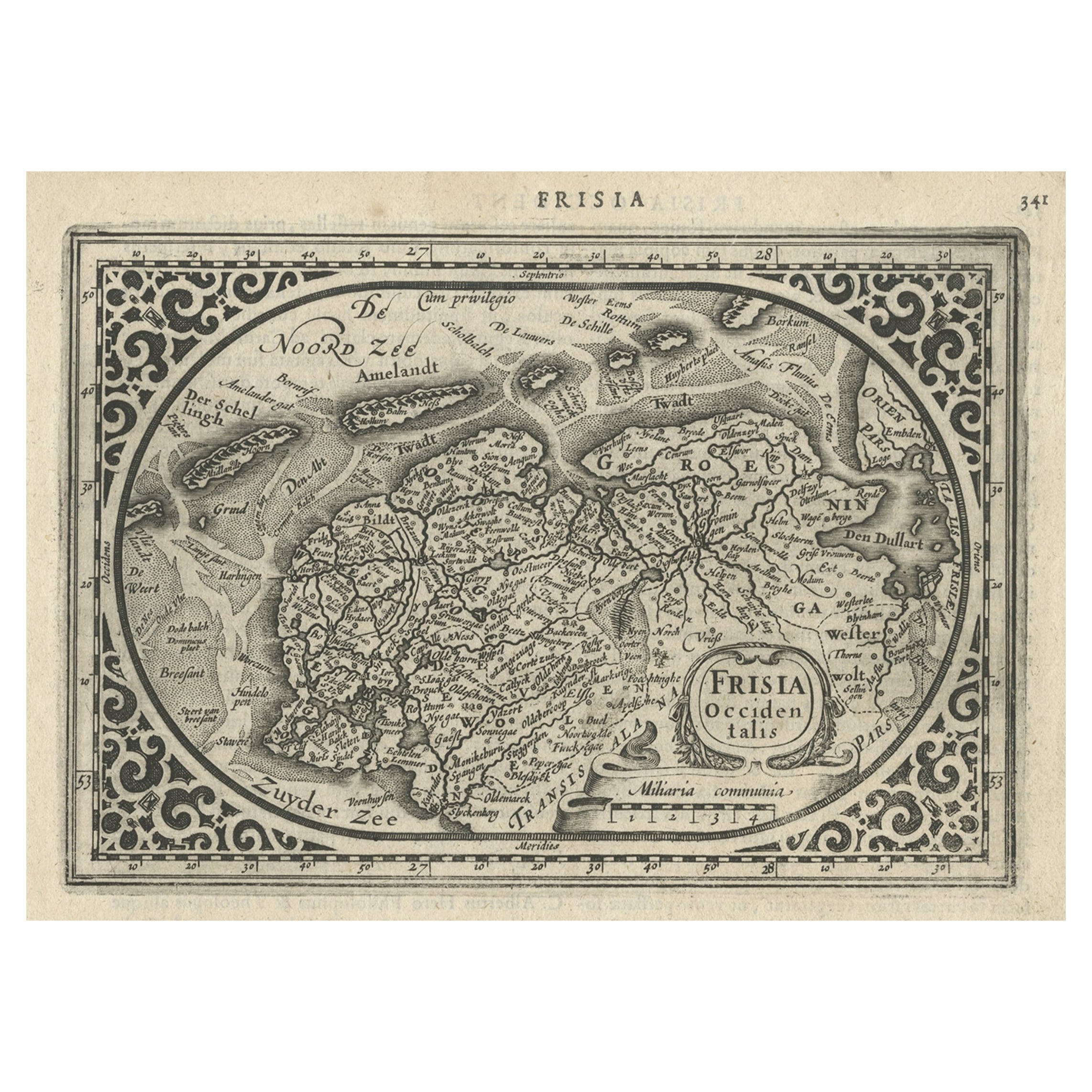
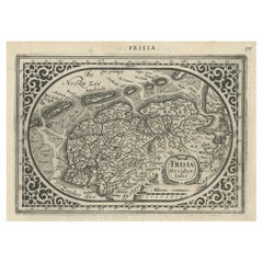
- Antique Map of Friesland and Groningen, Provinces of the Netherlands, 1628Located in Langweer, NLAntique map Friesland titled 'Frisia Occidentalis'. Small, decorative map of the province of Friesland, the Netherlands. Second state, out of three, originating from 'Atlas Minor' by...Category
Antique 17th Century Maps
MaterialsPaper
- Antique Map of the Islands of the Atlantic by J. TallisLocated in Langweer, NLA highly decorative and detailed mid-19th century map of the Islands of the Atlantic -- including the Azores, Madeira, Bermuda, the Canary Islands and the Cape Verde Islands -- which...Category
Antique Mid-19th Century Maps
MaterialsPaper
- Antique Map of the Atlantic Islands, 1817Located in Langweer, NLAntique map titled 'Atlantic Islands'. Large map of the Atlantic Islands include the Cape Verde islands, Canary islands, Azore islands and Madeira islands. Also included a view of th...Category
Antique Early 19th Century Maps
MaterialsPaper


You May Also Like
- Original Antique Map of The World by Thomas Clerk, 1817Located in St Annes, LancashireGreat map of The Eastern and Western Hemispheres On 2 sheets Copper-plate engraving Drawn and engraved by Thomas Clerk, Edinburgh. Published by Mackenzie And Dent, 1817 ...Category
Antique 1810s English Maps
MaterialsPaper
- Original Antique Map of The Netherlands, Engraved by Barlow, Dated 1807Located in St Annes, LancashireGreat map of Netherlands Copper-plate engraving by Barlow Published by Brightly & Kinnersly, Bungay, Suffolk. Dated 1807 Unframed.Category
Antique Early 1800s English Maps
MaterialsPaper
- Map of the Republic of GenoaLocated in New York, NYFramed antique hand-coloured map of the Republic of Genoa including the duchies of Mantua, Modena, and Parma. Europe, late 18th century. Dimension: 25...Category
Antique Late 18th Century European Maps
- Hand-Colored 18th Century Homann Map of Denmark and Islands in the Baltic SeaBy Johann Baptist HomannLocated in Alamo, CAAn 18th century copper plate hand-colored map entitled "Insulae Danicae in Mari Balthico Sitae utpote Zeelandia, Fionia, Langelandia, Lalandia, Falstria, Fembria Mona" created by Joh...Category
Antique Early 18th Century German Maps
MaterialsPaper
- Antique Map of Italy by Andriveau-Goujon, 1843By Andriveau-GoujonLocated in New York, NYAntique Map of Italy by Andriveau-Goujon, 1843. Map of Italy in two parts by Andriveau-Goujon for the Library of Prince Carini at Palazzo Carini i...Category
Antique 1840s French Maps
MaterialsLinen, Paper
- Original Antique Map of Russia By Arrowsmith. 1820Located in St Annes, LancashireGreat map of Russia Drawn under the direction of Arrowsmith Copper-plate engraving Published by Longman, Hurst, Rees, Orme and Brown, 1820 Unframed.Category
Antique 1820s English Maps
MaterialsPaper


Recently Viewed
View AllMore Ways To Browse
Island Maps
Antique Island Map
Antique Maps Of Islands
Copper Map
Mercator Map
17th Century Danish
Mercator Antique
Denmark Maps
Denmark Map
Map Zealand
Antique Map Denmark
Original Antique World Map
Map Of United States
Antique German Collectible
Authentic Antique Maps
The United States Map
Map France
Map Of The United States