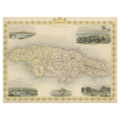
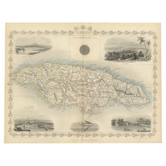
Antique Map of Jamaica with Decorative Vignettes
View Similar Items


Want more images or videos?
Request additional images or videos from the seller
1 of 6
Antique Map of Jamaica with Decorative Vignettes
About the Item
- Dimensions:Height: 10.48 in (26.6 cm)Width: 14.45 in (36.7 cm)Depth: 0.02 in (0.5 mm)
- Materials and Techniques:
- Period:
- Date of Manufacture:1851
- Condition:Age-related toning. Shows some wear and soiling. Few tiny tears in margins. Blank verso. Please study image carefully.
- Seller Location:Langweer, NL
- Reference Number:Seller: BG-13528-51stDibs: LU3054336187922
About the Seller
5.0
Platinum Seller
These expertly vetted sellers are 1stDibs' most experienced sellers and are rated highest by our customers.
Established in 2009
1stDibs seller since 2017
1,933 sales on 1stDibs
More From This SellerView All
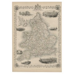
- An Ornate and Historical Tallis Map of Jamaica with Decorative Vignettes, 1851Located in Langweer, NLThis original antique map of Jamaica is part of the renowned series created by the Tallis Company, known for their detailed and decorative maps ...Category
Antique 1850s Maps
MaterialsPaper
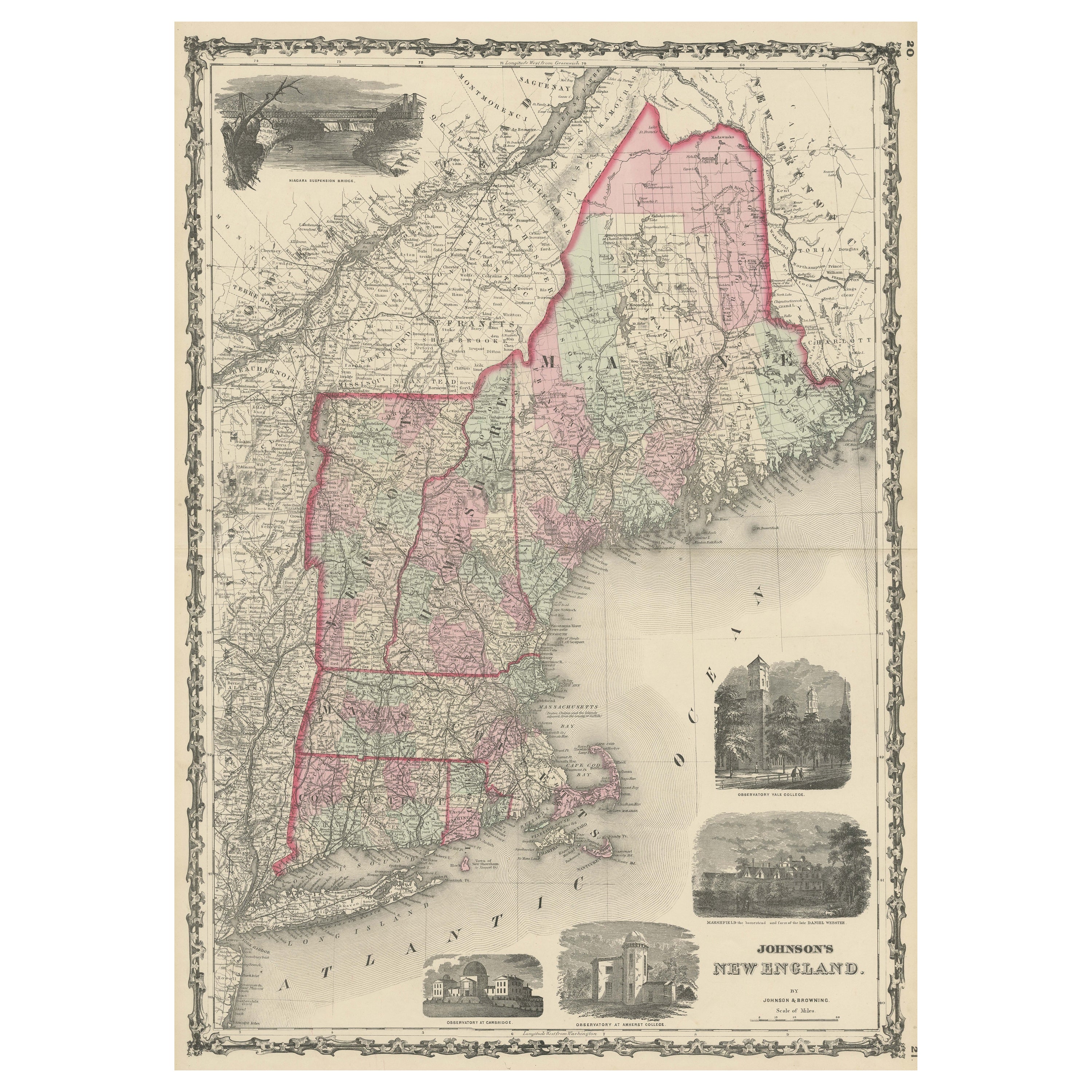
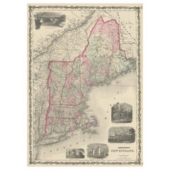
- Large Antique Map of New England with decorative VignettesLocated in Langweer, NLAntique map titled 'Johnson's New England'. Large map of New England, comprising the states Connecticut, Maine, Massachusetts, New Hampshire, Rhode ...Category
Antique Mid-19th Century Maps
MaterialsPaper
 $342 Sale Price20% Off
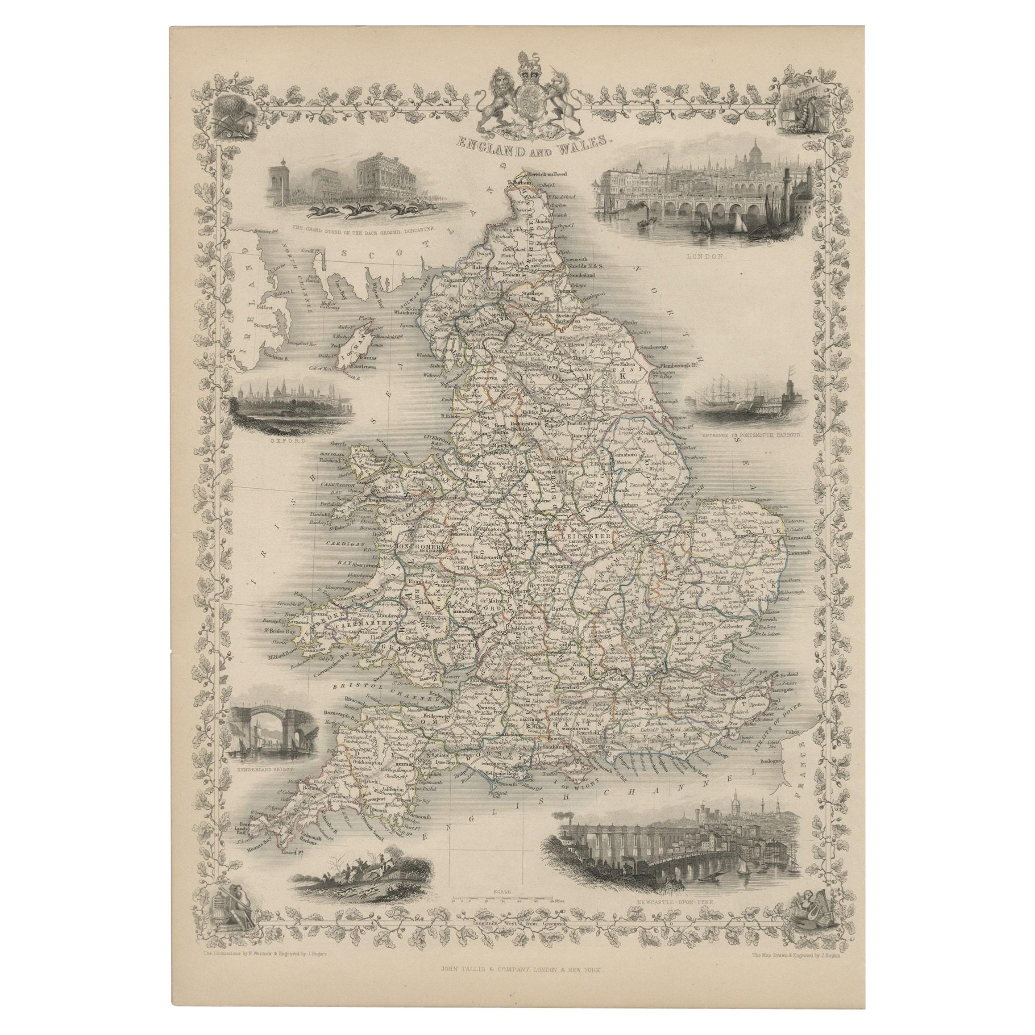
 - Antique Map of England and Wales with Decorative Vignettes, 1851Located in Langweer, NLAntique map titled ‘England and Wales’. Includes decorative vignettes titled The grand stand on the race ground Doncaster, London, Oxford, Entrance to Portsmouth Harbour, Sunderland ...Category
Antique 19th Century Maps
MaterialsPaper
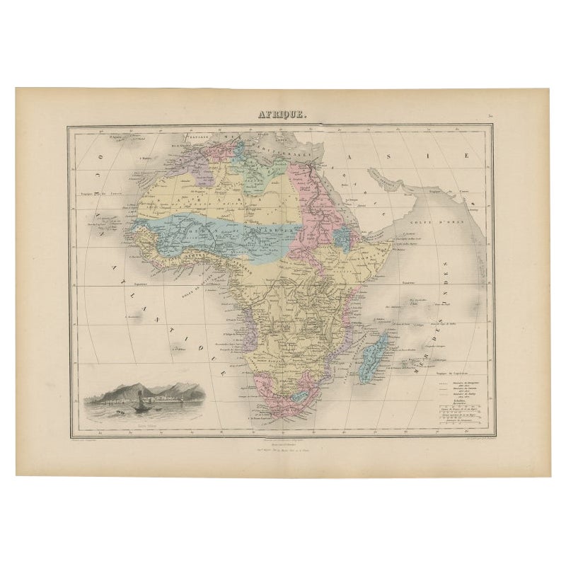
- Antique Map of Africa with Decorative Vignette of Saint Helena, 1880Located in Langweer, NLAntique map titled 'Afrique'. Old map of Africa, covering the African continent. With decorative vignette of Saint Helena. This map originates from 'Géogr...Category
Antique 19th Century Maps
MaterialsPaper
- Old Engraved Map of Hungary with Decorative Vignettes, 1851Located in Langweer, NLAntique map titled Hungary. Includes decorative vignettes titled Hungarian Peasants, Pesth and the Fortress of Buda, on the Danube and Hungarian Nobles. Originates from 'The Illustrated Atlas, And Modern History Of The World Geographical, Political, Commercial & Statistical, Edited By R. Montgomery Martin'. Published; John Tallis London, New York, Edinburgh & Dublin. 1851. Drawn and Engraved by J. Rapkin. Artists and Engravers: John Tallis (1817-1876) was a British map publisher. Born in the Midlands, Tallis came to London in the 1840s. Tallis began his London career with a series of remarkable London street views. He began a partnership with a Frederick Tallis, possibly his brother, but their collaboration ended in 1849. For the Great Exhibition of 1851, Tallis published the Illustrated World Atlas, one of the last series of decorative world maps ever produced. The maps were engraved by John Rapkin, a skilled artisan. The maps were later reissued by the London Printing & Publishing Company, who left the Tallis imprint intact, thus ensuring his enduring fame. In 1858, he began publication of the popular Illustrated News of the World...Category
Antique 19th Century Maps
MaterialsPaper
 $281 Sale Price20% Off
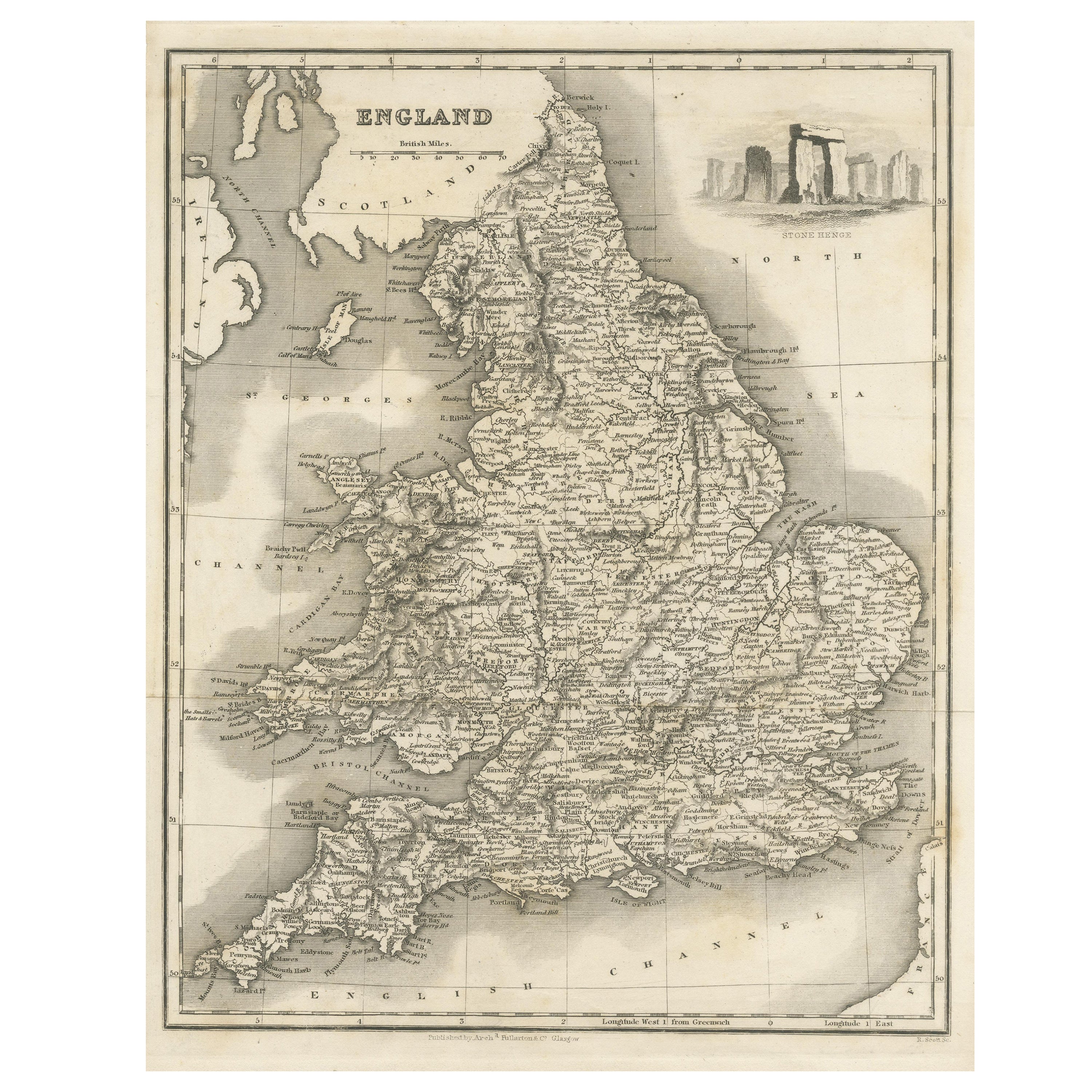
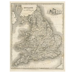
 - Antique Map of England with Vignette of StonehengeLocated in Langweer, NLAntique map titled 'England'. Original antique map of England, with decorative vignette of stonehenge. Engraved by R. Scott. Published by Fulla...Category
Antique Mid-19th Century Maps
MaterialsPaper

You May Also Like
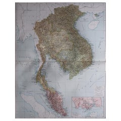
- Large Original Vintage Map of S.E Asia, with a Vignette of SingaporeLocated in St Annes, LancashireGreat map of South East Asia Original color. Good condition Published by Alexander Gross Unframed.Category
Vintage 1920s English Maps
MaterialsPaper
- Antique Map of American Cities, Vignette of New York City, circa 1920Located in St Annes, LancashireGreat maps of American Cities Unframed Original color By John Bartholomew and Co. Edinburgh Geographical Institute Published, circa 1920Category
Vintage 1920s British Maps
MaterialsPaper
- Original Antique Decorative Map of Japan, Fullarton, C.1870Located in St Annes, LancashireGreat map of Japan Wonderful figural border From the celebrated Royal Illustrated Atlas Lithograph. Original color. Published by Fullarton, Edinburgh, C.1870 Unframed...Category
Antique 1870s Scottish Maps
MaterialsPaper
- Original Antique Decorative Map of Iceland & Faroe, Fullarton, C.1870Located in St Annes, LancashireGreat map of Iceland and The Faroe Islands Wonderful figural border From the celebrated Royal Illustrated Atlas Lithograph. Original color. Published by Fullarton, Edinb...Category
Antique 1870s Scottish Maps
MaterialsPaper
- Original Antique Decorative Map of South America-West Coast, Fullarton, C.1870Located in St Annes, LancashireGreat map of Chili, Peru and part of Bolivia Wonderful figural border From the celebrated Royal Illustrated Atlas Lithograph. Original color. Published by Fullarton, Edi...Category
Antique 1870s Scottish Maps
MaterialsPaper
- Antique Map of Principality of MonacoBy Antonio Vallardi EditoreLocated in Alessandria, PiemonteST/619 - "Old Geographical Atlas of Italy - Topographic map of ex-Principality of Monaco" - ediz Vallardi - Milano - A somewhat special edition ---Category
Antique Late 19th Century Italian Other Prints
MaterialsPaper
 $228 Sale Price74% Off


Recently Viewed
View AllMore Ways To Browse
Oversized Map
Atlas School Supply
Matthew Seutter On Sale
Menorca Map
Pierre Fran�ois Tardieu On Sale
Rand Mcnally Map Of Kansas
Sumba Map
Vincenzo Coronelli On Sale
1681 Moses Pitt
Antique Cabbage Cutter
Antique Maps Denver
Antique Maps Washington Dc
Map Of Charlevoix
Marthas Vineyard Map
Union Pacific Map
Rand Mcnally Map Of California
Map Of Indonesia
United States Antique Map