Items Similar to Antique Map of the Kingdom of Prussia by Keizer & de Lat, 1788

Want more images or videos?
Request additional images or videos from the seller
1 of 5
Antique Map of the Kingdom of Prussia by Keizer & de Lat, 1788
About the Item
Antique map titled 't Koninkryk Pruissen (..)'. Uncommon original antique map of the Kingdom of Prussia. This map originates from 'Nieuwe Natuur- Geschied- en Handelkundige Zak- en Reisatlas' by Gerrit Brender à Brandis. Published by J. Keizer and I. de Lat, 1788.
- Dimensions:Height: 8.08 in (20.5 cm)Width: 10.63 in (27 cm)Depth: 0.02 in (0.5 mm)
- Materials and Techniques:
- Period:
- Date of Manufacture:1788
- Condition:General age-related toning. Original folding lines. Original/contemporary hand coloring, blank verso. Minor wear, please study image carefully.
- Seller Location:Langweer, NL
- Reference Number:
About the Seller
5.0
Platinum Seller
These expertly vetted sellers are 1stDibs' most experienced sellers and are rated highest by our customers.
Established in 2009
1stDibs seller since 2017
1,932 sales on 1stDibs
Typical response time: <1 hour
- ShippingRetrieving quote...Ships From: Langweer, Netherlands
- Return PolicyA return for this item may be initiated within 14 days of delivery.
More From This SellerView All
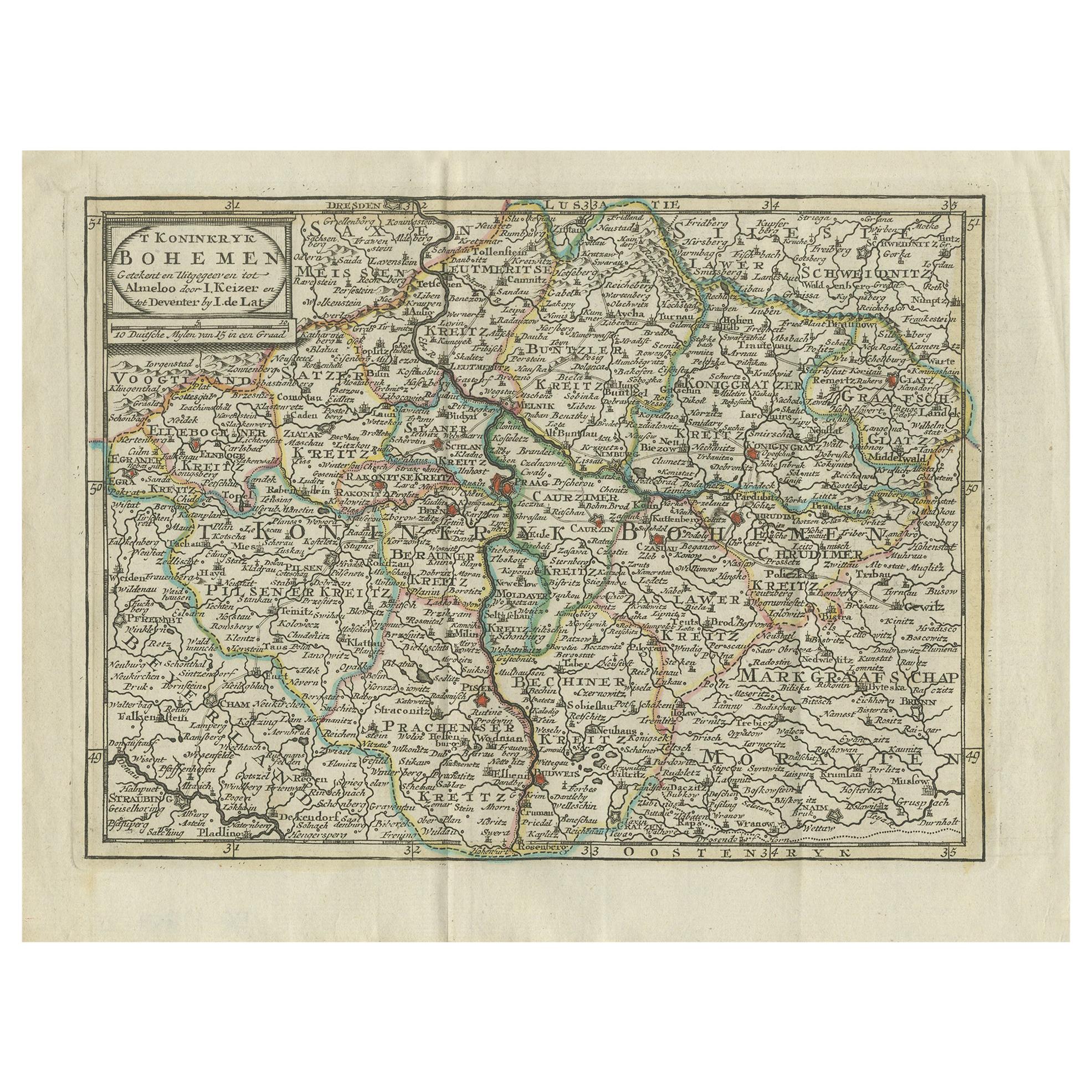
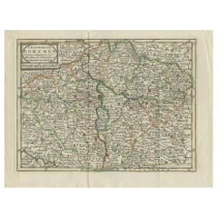
- Antique Map of the Kingdom of Bohemia by Keizer & de Lat, 1788Located in Langweer, NLAntique map titled 't Koninkryk Bohemen (..)'. Uncommon original antique map of the Kingdom of Bohemia. This map originates from 'Nieuwe Natuur- Geschied- en Handelkundige Zak- en Re...Category
Antique Late 18th Century Maps
MaterialsPaper
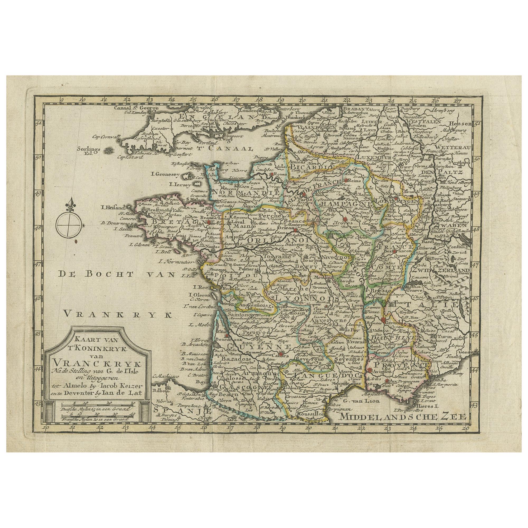
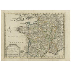
- Antique Map of the Kingdom of France by Keizer & de Lat, 1788Located in Langweer, NLAntique map titled 'Kaart van 't Koninkryk van Vranckryk'. Uncommon original antique map of the Kingdom of France. This map originates from 'Nieuwe Natuur- Geschied- en Handelkundige...Category
Antique Late 18th Century Maps
MaterialsPaper
- Antique Map of the Kingdom of Hungary by Keizer & de Lat, 1788Located in Langweer, NLAntique map titled 't Koninkryk Hongarien (..)'. Uncommon original antique map of the Kingdom of Hungary. This map originates from 'Nieuwe Natuur- Geschied- en Handelkundige Zak- en ...Category
Antique Late 18th Century Maps
MaterialsPaper
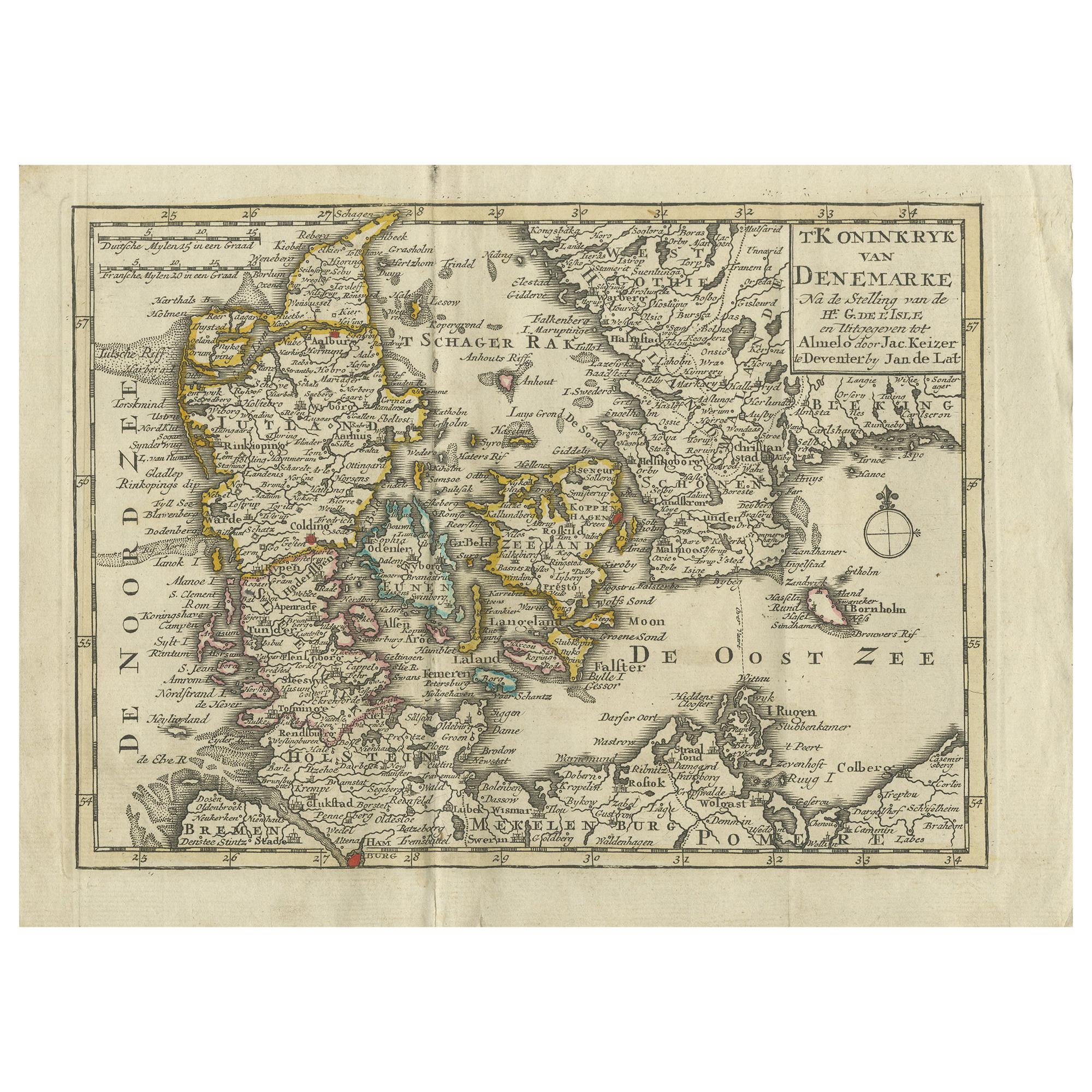
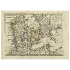
- Antique Map of the Kingdom of Denmark by Keizer & de Lat, 1788Located in Langweer, NLAntique map titled 't Koninkryk van Denemarke'. Uncommon original antique map of the Kingdom of Denmark. This map originates from 'Nieuwe Natuur- Geschied- en Handelkundige Zak- en R...Category
Antique Late 18th Century Maps
MaterialsPaper
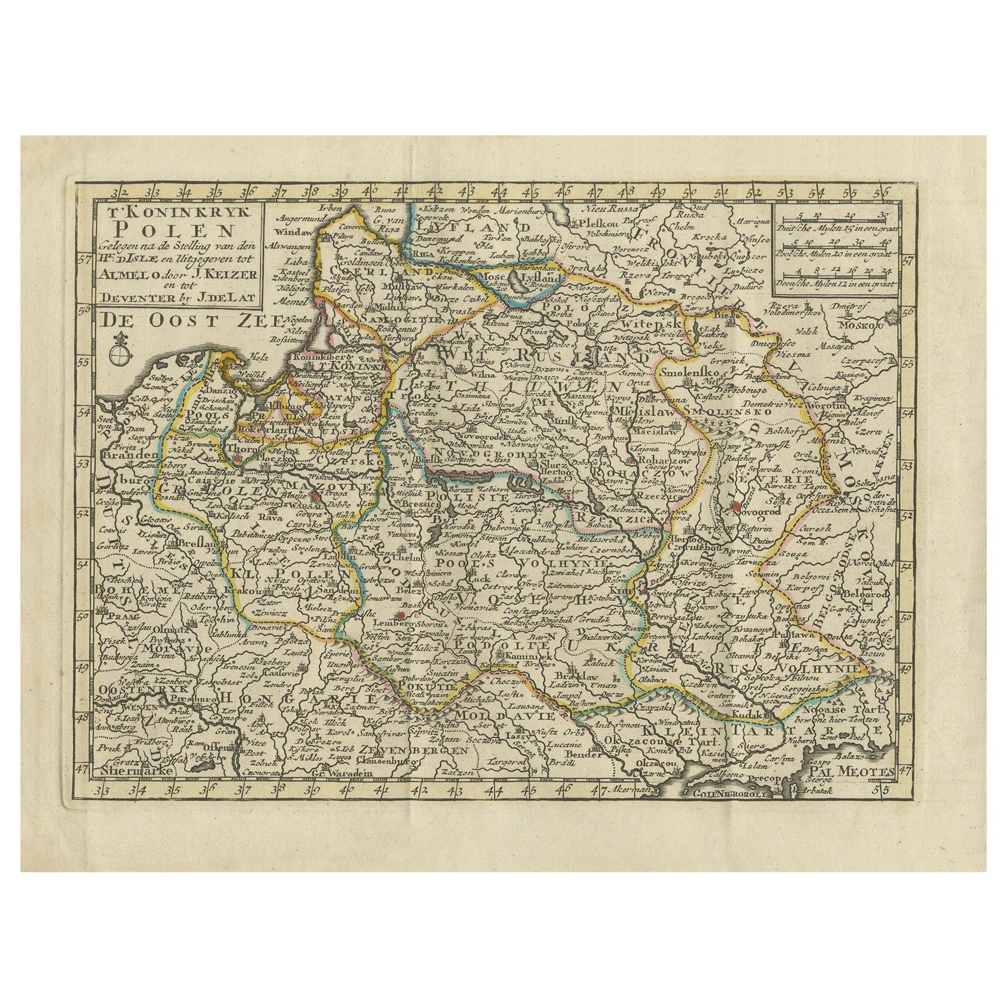
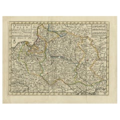
- Antique Map of the Kingdom of Poland by Keizer & de Lat, 1788Located in Langweer, NLAntique map titled 't Koninkryk Polen (..)'. Uncommon original antique map of the Kingdom of Poland. This map originates from 'Nieuwe Natuur- Geschied- en Handelkundige Zak- en Reisa...Category
Antique Late 18th Century Maps
MaterialsPaper
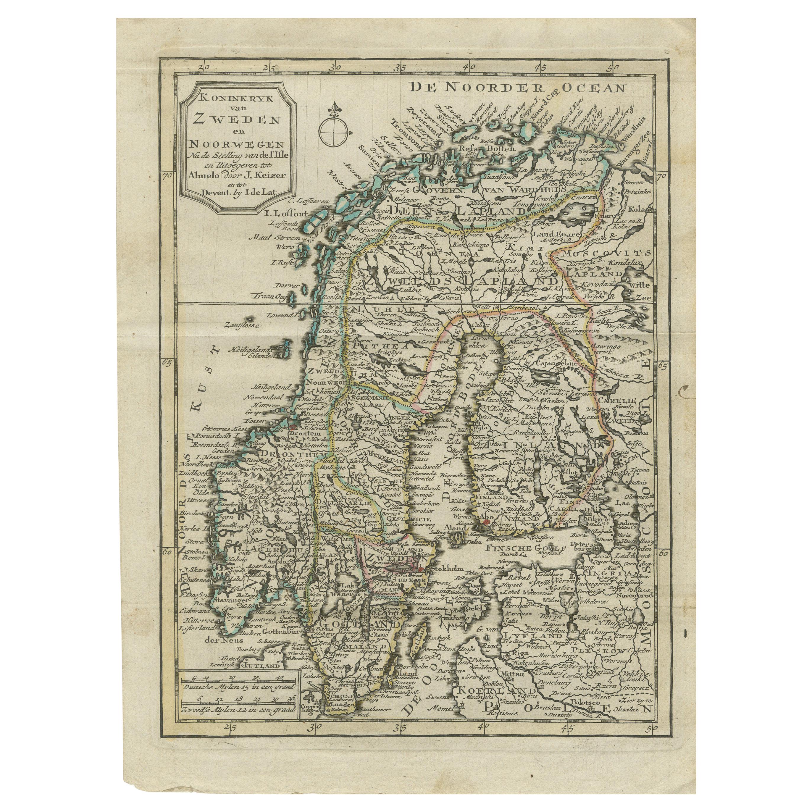
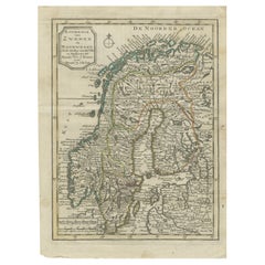
- Antique Map of the Kingdom of Sweden and Norway by Keizer & de Lat, 1788Located in Langweer, NLAntique map titled 't Koninkryk van Zweden en Noorwegen'. Uncommon original antique map of the Kingdom of Sweden and Norway. This map originates from 'Nieuwe Natuur- Geschied- en Han...Category
Antique Late 18th Century Maps
MaterialsPaper

You May Also Like
- Prussia, Poland, N. Germany, Etc: A Hand-colored 17th Century Map by JanssoniusBy Johannes JanssoniusLocated in Alamo, CAThis is an attractive hand-colored copperplate engraved 17th century map of Prussia entitled "Prussia Accurate Descripta a Gasparo Henneberg Erlichensi", published in Amsterdam by Joannes Janssonius in 1664. This very detailed map from the golden age of Dutch cartography includes present-day Poland, Latvia, Lithuania, Estonia and portions of Germany. This highly detailed map is embellished by three ornate pink, red, mint green and gold...Category
Antique Mid-17th Century Dutch Maps
MaterialsPaper
- The Kingdom of Naples and Southern Italy: A Hand-Colored 18th Century Homann MapBy Johann Baptist HomannLocated in Alamo, CA"Novissima & exactissimus Totius Regni Neapolis Tabula Presentis Belli Satui Accommo Data" is a hand colored map of southern Italy and the ancient Kingdom of Naples created by Johann...Category
Antique Early 18th Century German Maps
MaterialsPaper
- Original Antique Map of The World by Thomas Clerk, 1817Located in St Annes, LancashireGreat map of The Eastern and Western Hemispheres On 2 sheets Copper-plate engraving Drawn and engraved by Thomas Clerk, Edinburgh. Published by Mackenzie And Dent, 1817 ...Category
Antique 1810s English Maps
MaterialsPaper
- Original Antique Map of The Netherlands, Engraved by Barlow, Dated 1807Located in St Annes, LancashireGreat map of Netherlands Copper-plate engraving by Barlow Published by Brightly & Kinnersly, Bungay, Suffolk. Dated 1807 Unframed.Category
Antique Early 1800s English Maps
MaterialsPaper
- Map of the Holy Land "Carte de la Syrie et de l'Egypte" by Pierre M. LapieBy Pierre M. LapieLocated in Alamo, CAAn early 19th century map of ancient Syria and Egypt entitled "Carte de la Syrie et de l'Egypte anciennes/dressée par M. Lapie, Colonel d'Etat Major, et...Category
Antique Early 19th Century French Maps
MaterialsPaper
- Map of the Republic of GenoaLocated in New York, NYFramed antique hand-coloured map of the Republic of Genoa including the duchies of Mantua, Modena, and Parma. Europe, late 18th century. Dimension: 25...Category
Antique Late 18th Century European Maps


