Items Similar to Antique Map of the Malay Archipelago with Images of Indigenous People, 1851


Want more images or videos?
Request additional images or videos from the seller
1 of 7
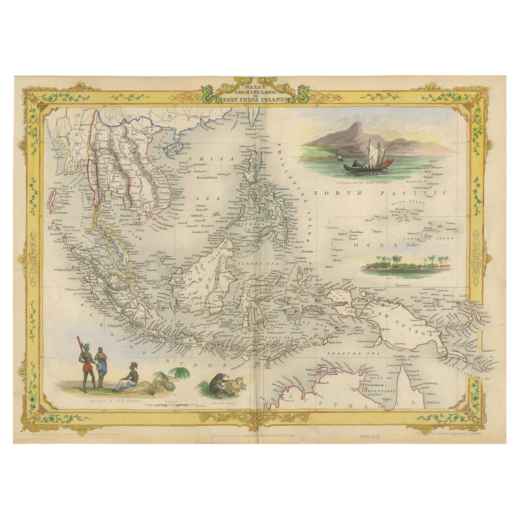
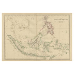
Antique Map of the Malay Archipelago with Images of Indigenous People, 1851
$325.63
$407.0420% Off
£240.20
£300.2520% Off
€272
€34020% Off
CA$451.18
CA$563.9720% Off
A$489.60
A$61220% Off
CHF 259.44
CHF 324.3020% Off
MX$6,004.68
MX$7,505.8520% Off
NOK 3,210.60
NOK 4,013.2520% Off
SEK 3,033.84
SEK 3,792.3020% Off
DKK 2,071.23
DKK 2,589.0420% Off
About the Item
John Tallis & Company, often simply known as Tallis, was renowned for the production of maps and illustrated geographical publications in the mid-19th century. Tallis maps, such as the one of Indonesia, are characterized by their meticulous detail, elaborate borders, and unique vignettes that offer a glimpse into the cultural and geographical context of the region depicted.
The map of Indonesia would have been part of Tallis's "The British Colonies" series, which was accompanied by the descriptive text of Robert Montgomery Martin. This series is a reflection of the Victorian era's fascination with the expanding British Empire and its dominions overseas.
The map itself would feature the archipelago known as Indonesia today, but at the time of the map's creation, the region was known as the Dutch East Indies, a collection of Dutch colonial territories. The map likely delineates various islands, straits, and important cities, emphasizing the strategic and economic significance of the archipelago.
The vignettes on a Tallis map serve as an illustrative guide to the local customs, notable landscapes, wildlife, and historical buildings, enriching the cartographic information with visual narratives that catered to the interests and imaginations of the British public.
Tallis's maps are more than just navigational aids; they are visual historical records that reflect the period's colonial mindset and artistic preferences. They represent the cultural and political ethos of an era when Britain was actively expanding and consolidating its global colonial reach. Today, these maps are valued for both their artistic merit and their historical significance, offering insights into the perception and representation of British colonies in the 19th century.
More in detail:
The images or insets on the map appear to be detailed illustrations typical of the Tallis style, providing cultural and geographical context to the regions depicted. Here's a description of each one:
1. **Natives of New Guinea**: This inset likely depicts indigenous people of New Guinea, showing their traditional attire and weapons. Such images were meant to convey the appearance and culture of the inhabitants to a 19th-century audience unfamiliar with the region.
2. **The second image is "The Bee Bear." This would refer to a Binturong, also known as a bearcat, which is a viverrid native to South and Southeast Asia. It is not a bear but gets its name from its bear-like appearance and its fondness for eating honey (bee). This animal is known for its thick fur and prehensile tail, and it is one of the few mammals that has a fully prehensile tail. It's a nocturnal creature, and the illustration likely aims to depict one of the unique species found in the Indonesian archipelago.
3. **Scene Near Sarawak, Borneo**: A peaceful coastal scene, perhaps illustrating a settlement or village in the vicinity of Sarawak, which is now part of Malaysia on the island of Borneo. This would highlight the local geography and settlement patterns.
4. **Victoria Mount, New Guinea**: Featuring a mountainous landscape with a traditional sailing vessel in the foreground, this inset captures the rugged terrain of New Guinea and provides a sense of the maritime culture of the region.
These insets serve as a visual encyclopedia of sorts, offering snapshots of life and nature in the region. They would have provided 19th-century audiences with an exotic glimpse of far-off lands, serving both educational and decorative purposes.
- Dimensions:Height: 10.71 in (27.2 cm)Width: 14.26 in (36.2 cm)Depth: 0 in (0.02 mm)
- Materials and Techniques:
- Period:
- Date of Manufacture:1851
- Condition:Good given age. Original fold in middle as published. General age-related toning, please study scan carefully.
- Seller Location:Langweer, NL
- Reference Number:Seller: BG-13736-81stDibs: LU3054339296412
About the Seller
5.0
Recognized Seller
These prestigious sellers are industry leaders and represent the highest echelon for item quality and design.
Platinum Seller
Premium sellers with a 4.7+ rating and 24-hour response times
Established in 2009
1stDibs seller since 2017
2,622 sales on 1stDibs
Typical response time: <1 hour
- ShippingRetrieving quote...Shipping from: Langweer, Netherlands
- Return Policy
Authenticity Guarantee
In the unlikely event there’s an issue with an item’s authenticity, contact us within 1 year for a full refund. DetailsMoney-Back Guarantee
If your item is not as described, is damaged in transit, or does not arrive, contact us within 7 days for a full refund. Details24-Hour Cancellation
You have a 24-hour grace period in which to reconsider your purchase, with no questions asked.Vetted Professional Sellers
Our world-class sellers must adhere to strict standards for service and quality, maintaining the integrity of our listings.Price-Match Guarantee
If you find that a seller listed the same item for a lower price elsewhere, we’ll match it.Trusted Global Delivery
Our best-in-class carrier network provides specialized shipping options worldwide, including custom delivery.More From This Seller
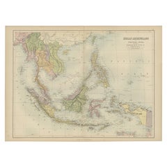
View AllDecorative Antique Map of the Malay Archipelago or East Indies Island, 1851
Located in Langweer, NL
Antique map Indonesia titled 'Malay Archipelago, or East India Islands'. With vignettes of Victoria Mount, New Guinea, Nativaes of New Guinea an...
Category
Antique 1850s Maps
Materials
Paper
$1,053 Sale Price
20% Off
Antique Map of the East Indies by W. G. Blackie, 1859
Located in Langweer, NL
Antique map titled 'The Indian Archipelago'. Original antique map of the East Indies. This map originates from ‘The Imperial Atlas of Modern Geography’. Published by W. G. Blackie, 1...
Category
Antique Mid-19th Century Maps
Materials
Paper
$263 Sale Price
20% Off
Antique Map of the East Indies by Van der Aa '1849'
Located in Langweer, NL
Antique map titled 'Kaart van Nederlands OostIndie door A.J. van der Aa'. Old map of the Dutch East Indies. This map originates from 'Nederlands Oost-Indië, of beschrijving der Neder...
Category
Antique Mid-19th Century Maps
Materials
Paper

$383 Sale Price
20% Off
Antique Map of the East Indies by Wyld '1845'
Located in Langweer, NL
Antique map titled 'Archipelago of the Indian Ocean'. Original antique map of the East Indies. This map originates from 'An Atlas of the World, Comprehending Separate Maps of its Var...
Category
Antique Mid-19th Century Maps
Materials
Paper

$335 Sale Price
20% Off
Antique Map of the East Indies by A & C. Black, 1870
Located in Langweer, NL
Antique map titled 'Indian Archipelago and Further India including Burmah, Siam, Anam &c'. Original antique map of Indian Archipelago and Further India. This map originates from ‘Bla...
Category
Antique Late 19th Century Maps
Materials
Paper
$263 Sale Price
20% Off
Antique Map of the East Indies by Levasseur, '1875'
Located in Langweer, NL
Antique map titled 'Carte de la Malaisie'. Large map of the East Indies. This map originates from 'Atlas de Géographie Moderne Physique et Politique' by A. Levasseur. Published 1875.
Category
Antique Late 19th Century Maps
Materials
Paper

$448 Sale Price
25% Off
You May Also Like
Original Antique Map of South East Asia by Thomas Clerk, 1817
Located in St Annes, Lancashire
Great map of South East Asia
Copper-plate engraving
Drawn and engraved by Thomas Clerk, Edinburgh.
Published by Mackenzie And Dent, 1817
Unframed.
Category
Antique 1810s English Maps
Materials
Paper

Antique 1803 Italian Map of Asia Including China Indoneseia India
Located in Amsterdam, Noord Holland
Antique 1803 Italian Map of Asia Including China Indoneseia India
Very nice map of Asia. 1803.
Additional information:
Type: Map
Country of Manufacturing: Europe
Period: 19th centu...
Category
Antique 19th Century European Maps
Materials
Paper

$584 Sale Price
20% Off
Large Original Antique Map of Java and Borneo, Fullarton, C.1870
Located in St Annes, Lancashire
Great map of Java and Borneo
Wonderful figurative borders
From the celebrated Royal Illustrated Atlas
Lithograph. Original color.
Published by Fullarton, Edinburgh. C.1870
Unfr...
Category
Antique 1870s Scottish Maps
Materials
Paper

Map of the East Indies: An Original 18th Century Hand-colored Map by E. Bowen
Located in Alamo, CA
This is an original 18th century hand-colored map entitled "An Accurate Map of the East Indies Exhibiting the Course of the European Trade both on the Continent and Islands" by Emanu...
Category
Mid-18th Century Old Masters Landscape Prints
Materials
Engraving

Large Original Antique Map of The Pacific Ocean, Fullarton, C.1870
Located in St Annes, Lancashire
Great map of The Pacific Ocean
From the celebrated Royal Illustrated Atlas
Lithograph by Swanston. Original color.
Published by Fullarton,...
Category
Antique 1870s Scottish Maps
Materials
Paper

Antique French Map of Asia Including China Indoneseia India, 1783
Located in Amsterdam, Noord Holland
Very nice map of Asia. 1783 Dedie au Roy.
Additional information:
Country of Manufacturing: Europe
Period: 18th century Qing (1661 - 1912)
Condition: Overall Condition B (Good Used)...
Category
Antique 18th Century European Maps
Materials
Paper

$648 Sale Price
20% Off
More Ways To Browse
Indigenous Furniture
Mid Century Modern Danish Teak Dining Tables
Long Rug Runners
Pair Arm Chairs
Sterling Silver Dinner Sets
United Chair Company
Italian Beech Chairs
Shirvan Rugs
Spain Marble
Vintage Danish Tables And Chairs
1960s Glass Top Coffee Table
Black Glass Coffee Tables
Burnt Wood
Mid Century Wrought Iron Chairs
Earth Toned Rug
Black Marble Table Vintage
Goblets
Mid Century Modern Yellow Chair