Items Similar to A Gold Highlighted Antique Map of Northamptonshire by Blaeu '1659'


Want more images or videos?
Request additional images or videos from the seller
1 of 5
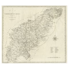
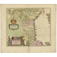
A Gold Highlighted Antique Map of Northamptonshire by Blaeu '1659'
About the Item
Antique map titled 'Comitatus Northantonensis vernacule Northamtonshire'. Original antique map of Northamptonshire, England. This map originates from 'Atlas Universal y Cosmographico de las Orbes Celestes y Terrestres' by J. Blaeu. Published 1659.
- Dimensions:Height: 18.9 in (48 cm)Width: 22.05 in (56 cm)Depth: 0.02 in (0.5 mm)
- Materials and Techniques:
- Period:Mid-17th Century
- Date of Manufacture:1659
- Condition:Beautiful coloring, heightened with gold! Spanish text on verso. General age-related toning, minor wear. Few small holes affecting image. Please study images carefully.
- Seller Location:Langweer, NL
- Reference Number:Seller: BG-12705-131stDibs: LU3054321245682
About the Seller
5.0
Platinum Seller
These expertly vetted sellers are 1stDibs' most experienced sellers and are rated highest by our customers.
Established in 2009
1stDibs seller since 2017
1,932 sales on 1stDibs
Typical response time: <1 hour
- ShippingRetrieving quote...Ships From: Langweer, Netherlands
- Return PolicyA return for this item may be initiated within 14 days of delivery.
Auctions on 1stDibs
Our timed auctions are an opportunity to bid on extraordinary design. We do not charge a Buyer's Premium and shipping is facilitated by 1stDibs and/or the seller. Plus, all auction purchases are covered by our comprehensive Buyer Protection. Learn More
More From This SellerView All
- Large Antique County Map of Northamptonshire, EnglandLocated in Langweer, NLAntique map titled 'A Map of Northamptonshire from the best Authorities'. Original old county map of Northamptonshire, England. Engraved by John Cary. Originates from 'New British At...Category
Antique Early 19th Century Maps
MaterialsPaper
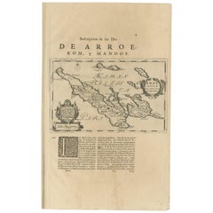
- Antique Map of Aero by Blaeu, 'circa 1670'Located in Langweer, NLAntique map titled 'Aroe Insulae delineatio geometrica'. Old map of Aero, a small Danish island in the Baltic Sea. This map originates from a Spanish edition of 'Atlas Maior' by J. B...Category
Antique Mid-17th Century Maps
MaterialsPaper
- Antique Map of Prussia by Blaeu, circa 1635By Willem BlaeuLocated in Langweer, NLAntique map titled 'Prussiae Nova Tabula'. Rare early edition of Blaeu's map of Prussia, embellished with a gorgeous large format cartouche, compass ros...Category
Antique Mid-17th Century Maps
MaterialsPaper
- Antique Map of Catalonia by Blaeu, circa 1650Located in Langweer, NLAntique map titled 'Catalonia'. Antique map of Catalonia, extending from C. De Romani on the Northern Coast to Alfachs and Panicola in Valencia on the southern end of the coast and s...Category
Antique Mid-17th Century Maps
MaterialsPaper
- Antique Map of Central Sweden by J. Blaeu, 1662Located in Langweer, NLA striking, rare map with a cartouche dedicated to Gabriel Bengtsson Oxenstierna. Published by J. Bleau, Amsterdam, 1662. Contemporary coloring.Category
Antique Mid-17th Century Maps
MaterialsPaper
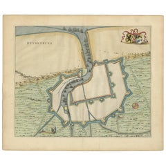
- Antique Map of Dunkirk 'France' by J. Blaeu, 1649Located in Langweer, NLAntique map titled 'Duynkercka'. Published by J. Blaeu, 1649. Dutch text on verso.Category
Antique Mid-17th Century Maps
MaterialsPaper


You May Also Like
- Antique Map of Italy by Andriveau-Goujon, 1843By Andriveau-GoujonLocated in New York, NYAntique Map of Italy by Andriveau-Goujon, 1843. Map of Italy in two parts by Andriveau-Goujon for the Library of Prince Carini at Palazzo Carini i...Category
Antique 1840s French Maps
MaterialsLinen, Paper
- Antique Map of Principality of MonacoBy Antonio Vallardi EditoreLocated in Alessandria, PiemonteST/619 - "Old Geographical Atlas of Italy - Topographic map of ex-Principality of Monaco" - ediz Vallardi - Milano - A somewhat special edition ---Category
Antique Late 19th Century Italian Other Prints
MaterialsPaper
- Large Antique 1859 Map of North AmericaLocated in Sag Harbor, NYThis Map was made by Augustus Mitchell in 1859 It is in amazing condition for being 163 years old. This price is for the rolled up easy to ship version of this piece. I will be Frami...Category
Antique Mid-19th Century American Maps
MaterialsCanvas, Paper

- Antique Lithography Map, Northamptonshire, English, Framed Cartography, C.1860Located in Hele, Devon, GBThis is an antique lithography map of Northamptonshire. An English, framed atlas engraving of cartographic interest, dating to the mid 19th century...Category
Antique Mid-19th Century British Victorian Maps
MaterialsWood
- Antique 18th Century Map of the Province of Pensilvania 'Pennsylvania State'Located in Philadelphia, PAA fine antique of the colony of Pennsylvania. Noted at the top of the sheet as a 'Map of the province of Pensilvania'. This undated and anonymous map is thought to be from the Gentleman's Magazine, London, circa 1775, although the general appearance could date it to the 1760's. The southern boundary reflects the Mason-Dixon survey (1768), the western boundary is placed just west of Pittsburgh, and the northern boundary is not marked. The map has a number of reference points that likely refer to companion text and appear to be connected to boundaries. The western and southern boundaries are marked Q, R, S, for example. A diagonal line runs from the Susquehanna R to the Lake Erie P. A broken line marked by many letters A, B, N, O, etc., appears in the east. There are no latitude or longitude markings, blank verso. Framed in a shaped contemporary gilt wooden frame and matted under a cream colored matte. Bearing an old Graham Arader Gallery...Category
Antique 18th Century British American Colonial Maps
MaterialsPaper
- Map of the Republic of GenoaLocated in New York, NYFramed antique hand-coloured map of the Republic of Genoa including the duchies of Mantua, Modena, and Parma. Europe, late 18th century. Dimension: 25...Category
Antique Late 18th Century European Maps


Recently Viewed
View AllMore Ways To Browse
Map Of England
Antique 17th Century Map
Antique Maps Of England
Antique Map Of England
Blaeu Maps
Map Blaeu
Antique Orb
Antique Map Blaeu
Antique Furniture Northamptonshire
Map Plate
Island Maps
Antique Maps Of France
Antique Map Of France
Antique Historical Maps
16th Century World Map
Antique Old Maps
Old Antique Maps
Germany Map