Items Similar to Antique Map of Overijssel by De Wit, c.1680


Want more images or videos?
Request additional images or videos from the seller
1 of 5
Antique Map of Overijssel by De Wit, c.1680
About the Item
Antique map titled 'Transisalania Provincia Vulgo Over-Yssel'. Original antique map of Overijssel, the Netherlands, showing the regio between Zutphen, Zwolle, Blokzijl, Coevorden, Oldenzaal and Enschede. Published by Frederik de Wit, Amsterdam. Artists and Engravers: Cartographers: Nicolaas ten Have and Frederik de Wit. Publisher: Frederik de Wit.
Artist: Cartographers: Nicolaas ten Have and Frederik de Wit. Publisher: Frederik de Wit.
Condition: Good, given age. Original middle fold, as issued. Middle fold reinforced with contemporary paper on the verso (rear). Margins dampstained. Minimal paper loss in the left margin. A small manuscript annotation in the top right margin. General age-related toning and/or occasional minor defects from handling. Few tiny tears in margins. Blank verso. Please study image carefully.
Date: c.1680
Overall size: 57.8 x 48.3 cm.
Image size: 0.001 x 53.5 x 46.2 cm.
Antique prints have long been appreciated for both their aesthetic and investment value. They were the product of engraved, etched or lithographed plates. These plates were handmade out of wood or metal, which required an incredible level of skill, patience and craftsmanship. Whether you have a house with Victorian furniture or more contemporary decor an old engraving can enhance your living space. We offer a wide range of authentic antique prints for any budget.
- Dimensions:Height: 19.02 in (48.3 cm)Width: 22.76 in (57.8 cm)Depth: 0 in (0.01 mm)
- Materials and Techniques:
- Period:
- Date of Manufacture:circa 1680
- Condition:
- Seller Location:Langweer, NL
- Reference Number:
About the Seller
5.0
Platinum Seller
These expertly vetted sellers are 1stDibs' most experienced sellers and are rated highest by our customers.
Established in 2009
1stDibs seller since 2017
1,922 sales on 1stDibs
Typical response time: <1 hour
- ShippingRetrieving quote...Ships From: Langweer, Netherlands
- Return PolicyA return for this item may be initiated within 14 days of delivery.
More From This SellerView All
- Antique Map of Denmark by F. de Wit, 1680Located in Langweer, NLAntique map titled 'Dania Regnum'. Large, attractive map of Denmark, Sleschwig-Holstein and southern Sweden. Good detail throughout. Embellished with a title cartouche with the Danis...Category
Antique Late 17th Century Maps
MaterialsPaper
- Large Antique Map of France by De Wit, c.1680By Frederick de WitLocated in Langweer, NLAntique map titled 'Accuratissima Galliae Tabula vulgo Royaume de France'. Detailed map of France. Shows provinces, cities, rivers etc. Artists and Engravers: Frederick de Wit (1...Category
Antique 17th Century Maps
MaterialsPaper
- Antique Map of Flanders 'Belgium' by F. de Wit, circa 1680Located in Langweer, NLAntique map titled 'Comitatus Flandriae Tabula, in Lucem Edita'. Large map of Flanders, Belgium. Published by F. de Wit, circa 1680.Category
Antique Late 17th Century Maps
MaterialsPaper
- Antique Map of South Sweden 'Scandinavia' by F. de Wit, 1680Located in Langweer, NLAntique map titled 'Accurata Scaniae, Blekingae et Hallandiae Descriptio per F. de Wit Amstelodami'. This map shows South Sweden with an inset of Halmstad and vicinity. Contemporary ...Category
Antique Late 17th Century Maps
MaterialsPaper
- Antique Map of Southern Germany by F. de Wit, circa 1680Located in Langweer, NLThis antique map depicts a portion of southern Germany that included the historic regions of Bavaria, the Palatinate, Prussia-Brandenburg, the Rhineland and Saxony. Regensberg, Freis...Category
Antique Late 17th Century Maps
MaterialsPaper
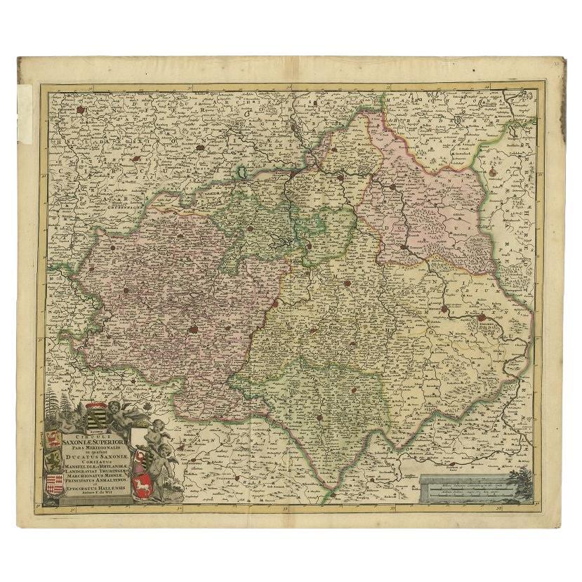
- Antique Map of the Duchy of Saxony by De Wit, c.1680Located in Langweer, NLAntique map titled 'Circuli Saxoniae Superior Pars Meridionalis in qua sunt Ducatus Saxoniae, Comitatus Mansfeldiae, et Voitlandiae, Landgraviat Thuringiae, Marchionatus Misniae Prin...Category
Antique 17th Century Maps
MaterialsPaper


You May Also Like
- Germany West of the Rhine: A Hand-colored 18th Century Map by de WitBy Frederick de WitLocated in Alamo, CAThis original 18th century hand-colored map of the county of Moers, Germany entitled "Illustrissimo Celsissmo Principi GUILIELMO HENRICO D.G. Arausionum Principi Domino suo Clementis...Category
Antique Early 18th Century Dutch Maps
MaterialsPaper
- Persia, Armenia & Adjacent Regions: A 17th Century Hand-colored Map by De WitBy Frederick de WitLocated in Alamo, CAA large 17th century hand colored copperplate engraved map entitled "Novissima nec non Perfectissima Scandinaviae Tabula comprehendens Regnorum Sueciae, Daniae et Norvegiae distincte...Category
Antique Late 17th Century Dutch Maps
MaterialsPaper
- Large 17th Century Hand Colored Map of England and the British Isles by de WitBy Frederick de WitLocated in Alamo, CAA large hand colored 17th century map of England and the British Isles by Frederick de Wit entitled "Accuratissima Angliæ Regni et Walliæ Principatus", published in Amsterdam in 1680. It is a highly detailed map of England, Scotland, the Scottish Isles...Category
Antique Late 17th Century Dutch Maps
MaterialsPaper
- 1907 Map of Colorado, Antique Topographical Map, by Louis NellLocated in Colorado Springs, COThis highly detailed pocket map is a topographical map of the state of Colorado by Louis Nell from 1907. The map "has been complied from all availabl...Category
Antique Early 1900s American Maps
MaterialsPaper
- 1861 Topographical Map of the District of Columbia, by Boschke, Antique MapLocated in Colorado Springs, COPresented is an original map of Albert Boschke's extremely sought-after "Topographical Map of the District of Columbia Surveyed in the Years 1856 ...Category
Antique 1860s American Historical Memorabilia
MaterialsPaper
- Antique Map of Paris, "Carte Routiere des Environs de Paris" 1841Located in Colorado Springs, COThis beautiful hand-colored road map of Paris was published in 1841. The map shows Paris and the surrounding area in a folding pocket map. Organized and detailed for travelers, this ...Category
Antique 1840s French Maps
MaterialsPaper


Recently Viewed
View AllMore Ways To Browse
Antique Plate With Metal Handle
Antique Manuscript Paper
17th Century Manuscript
Antique Middle Ages Manuscript
Small Antique Globes
Antique Surveying
Maps United Kingdom
Antique Style Map
Antique City Plans
Antique New York Maps
Antique Maps New York
Antique New York Map
Antique Map New York
Old Antique Globes
New York Antique Map
Modes And More
Antique Scottish Wood Furniture
Antique Map Scotland