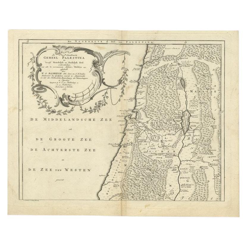
Items Similar to Antique Map of Southern Palestine by Bachiene, 1763


Want more images or videos?
Request additional images or videos from the seller
1 of 5
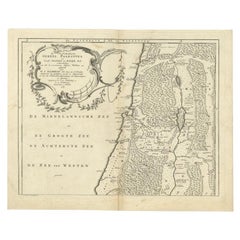
Antique Map of Southern Palestine by Bachiene, 1763
About the Item
"Antique map of the south part of Palestine. This simplified map shows the most important cities of the Jewish Land. Source unknown, to be determined. Artists and Engravers: Made by 'Willem Albert Bachiene' after 'O. Lindeman'. Author: Willem Albert Bachiene (Leerdam 1712 - Maastricht 1783). He was a Clergyman in the army and in Namen, Belgium and Kuilenburg (Culemborg). From 1759 he was Clergyman in Maastricht and also Professor in Astronomy and Geography at the 'Illustere School'.
Artist: Made by 'Willem Albert Bachiene' after 'O. Lindeman'. Author: Willem Albert Bachiene (Leerdam 1712 - Maastricht 1783). He was a Clergyman in the army and in Namen, Belgium and Kuilenburg (Culemborg). From 1759 he was Clergyman in Maastricht and also Professor in Astronomy and Geography at the 'Illustere School'.
Antique prints have long been appreciated for both their aesthetic and investment value. They were the product of engraved, etched or lithographed plates. These plates were handmade out of wood or metal, which required an incredible level of skill, patience and craftsmanship. Whether you have a house with Victorian furniture or more contemporary decor an old engraving can enhance your living space. We offer a wide range of authentic antique prints for any budget.".
- Dimensions:Height: 15.52 in (39.4 cm)Width: 19.18 in (48.7 cm)Depth: 0 in (0.01 mm)
- Materials and Techniques:
- Period:
- Date of Manufacture:1763
- Condition:Condition: Good, given age. Discolouration middle fold. Minor paper separation bottom middle fold, not affecting image. Original middle fold as issued. General age-related toning and/or occasional minor defects from handling. Study scan carefully.
- Seller Location:Langweer, NL
- Reference Number:
About the Seller
5.0
Platinum Seller
These expertly vetted sellers are 1stDibs' most experienced sellers and are rated highest by our customers.
Established in 2009
1stDibs seller since 2017
1,929 sales on 1stDibs
Typical response time: <1 hour
- ShippingRetrieving quote...Ships From: Langweer, Netherlands
- Return PolicyA return for this item may be initiated within 14 days of delivery.
More From This SellerView All
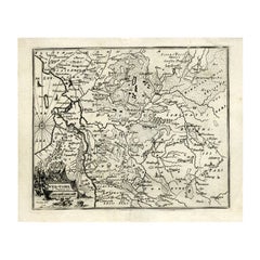
- Antique Map of the Northern Part of Biblical Palestine by Lindeman, c.1763Located in Langweer, NLAntique map titled 'De 8ste en 9de Landkaarte Geheel Palestina (..).' Map of the northern part of Biblical Palestine. With large title cartouche. Published by A. van Paddenburg, Neth...Category
Antique 18th Century Maps
MaterialsPaper
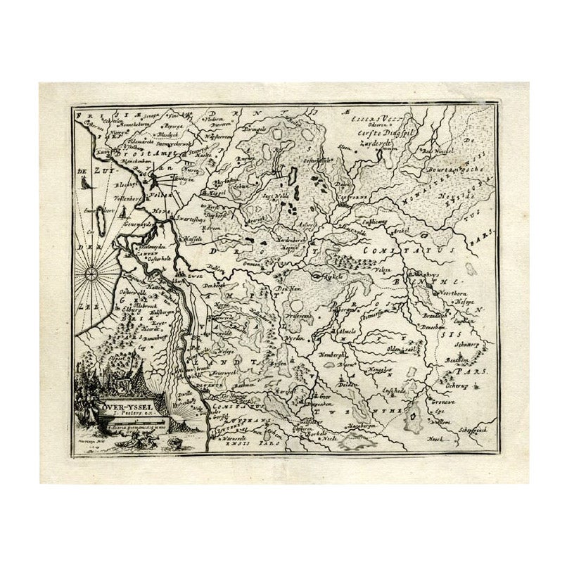
- Antique Map of Overijssel by Bachiene, 1758Located in Langweer, NLAntique map titled 'Over-Yssel'. Map of the Overijssel, the Netherlands. This map originates from 'Kort begrip der Oude en Nieuwe Staatkundige Geographie', by W.A. Bachiene, publishe...Category
Antique 18th Century Maps
MaterialsPaper
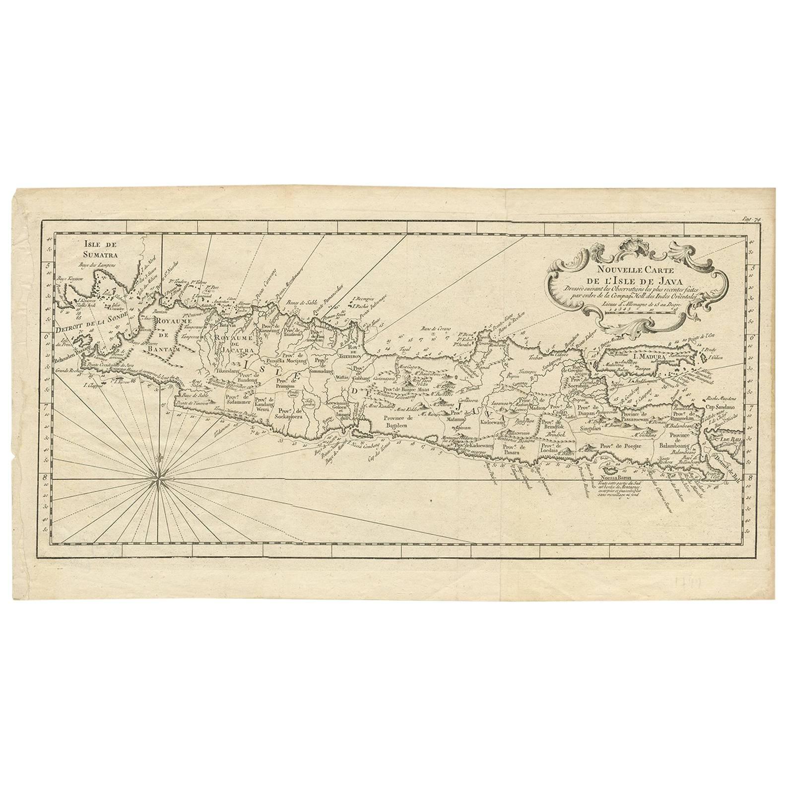
- Antique Map of Java 'Indonesia' by Arkstee & Markus (1763)Located in Langweer, NLAntique map titled 'Nouvelle carte de l'Isle de Java (..)'. This very detailed and rare map shows the island of Java, Indonesia. With cartouche, scale and compass rose. This map orig...Category
Antique Mid-18th Century Maps
MaterialsPaper
- Antique Map of the City of Paris by Tirion '1763'Located in Langweer, NLAntique map titled 'Nieuwe Kaart der platte Grond van de Stad Parys (..)'. Beautiful city plan of Paris, France. This map originates from 'Nieuwe en Beknopte Hand-Atlas, bestaande in...Category
Antique Mid-18th Century Maps
MaterialsPaper
- Antique Map of The Nile, Egypt and the Red Sea by Bachiene, 1765Located in Langweer, NLAntique map titled 'De XIde Landkaart verbeeldende Egypte en de Woestyne der Schelf-Zee (..).' Map of Biblical Egypt and the Red Sea. With title cartouche, compass rose and scale. Th...Category
Antique 18th Century Maps
MaterialsPaper
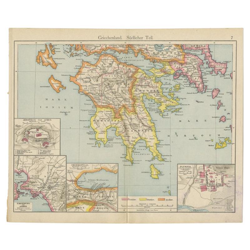
- Antique Map of Southern Greece, 1892Located in Langweer, NLAntique map of Greece titled 'Griechenland. Südlicher Theil'. Old map of Southern Greece with inset maps of the Acropolis of Athens, the region of Athens, Thermopylae and Olympia. So...Category
Antique 19th Century Maps
MaterialsPaper


You May Also Like
- New Map of North America from the Latest Discoveries, 1763Located in Philadelphia, PAA fine antique 18th century map of the North American seaboard. Entitled "A New Map of North America from the Latest Discoveries 1763". By the Cartographer/Engraver - John Spil...Category
Antique Mid-18th Century English Georgian Maps
MaterialsPaper
- 18th Century Map of the Southern Balkans by Giovanni Maria CassiniBy Giovanni Maria CassiniLocated in Hamilton, Ontario18th century map by Italian engraver Giovanni Maria Cassini (Italy 1745-1824). Map of the Southern Balkans: Rome. Hand colored and copper engraved print done in the year 1788. It in...Category
Antique 18th Century Italian Maps
MaterialsPaper
- 1861 Topographical Map of the District of Columbia, by Boschke, Antique MapLocated in Colorado Springs, COPresented is an original map of Albert Boschke's extremely sought-after "Topographical Map of the District of Columbia Surveyed in the Years 1856 ...Category
Antique 1860s American Historical Memorabilia
MaterialsPaper
- 1907 Map of Colorado, Antique Topographical Map, by Louis NellLocated in Colorado Springs, COThis highly detailed pocket map is a topographical map of the state of Colorado by Louis Nell from 1907. The map "has been complied from all availabl...Category
Antique Early 1900s American Maps
MaterialsPaper
- Map Southern Scotland Thomas Conder Alex Hogg 1795Located in BUNGAY, SUFFOLKA new map of the southern part of Scotland containing the counties of Stirling, Lanerk, Renfrew, Linlithgow, Edinburgh, Peebles, Haddingtoun, Berwick, Selkirk, Roxburgh, Dumfries, Wigtoun, Kirkudbright & Air Published by Alex Hogg at the Kings Arms...Category
Antique 18th Century English Georgian Maps
MaterialsPaper
- Antique Map of Italy by Andriveau-Goujon, 1843By Andriveau-GoujonLocated in New York, NYAntique Map of Italy by Andriveau-Goujon, 1843. Map of Italy in two parts by Andriveau-Goujon for the Library of Prince Carini at Palazzo Carini i...Category
Antique 1840s French Maps
MaterialsLinen, Paper


Recently Viewed
View AllMore Ways To Browse
Southern Used Furniture
Antique Plate With Metal Handle
Lithograph City Maps
City Map Lithograph
Jewish Antiques
Antique School Maps
Antique School Map
Map Of Belgium
Palestine Antique
Albert Willem
Belgium Antique Map
Jewish Etch
Belgium Army
Belgian Army
Old School Maps
Map Of Palestine
Palestine Map
Maastricht Plate