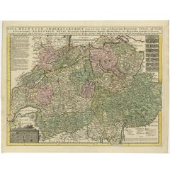
Antique Map of Switzerland by Covens & Mortier, 1749
View Similar Items


Want more images or videos?
Request additional images or videos from the seller
1 of 5
Antique Map of Switzerland by Covens & Mortier, 1749
About the Item
- Creator:Covens & Mortier (Artist)
- Dimensions:Height: 20.67 in (52.5 cm)Width: 26.38 in (67 cm)Depth: 0.02 in (0.5 mm)
- Materials and Techniques:
- Period:
- Date of Manufacture:1749
- Condition:Please study images carefully.
- Seller Location:Langweer, NL
- Reference Number:Seller: BGI-000931stDibs: LU305439105391
About the Seller
5.0
Platinum Seller
These expertly vetted sellers are 1stDibs' most experienced sellers and are rated highest by our customers.
Established in 2009
1stDibs seller since 2017
1,933 sales on 1stDibs
More From This SellerView All
- Antique Map of Denmark by Covens & Mortier, 1730By Covens & MortierLocated in Langweer, NLAntique Map of Denmark from: 'Atlas Nouveau ... Par Guillaume de l'Isle' Amsterdam, Covens & Mortier, 1730.Category
Antique Mid-18th Century Maps
MaterialsPaper
 $388 Sale Price40% Off
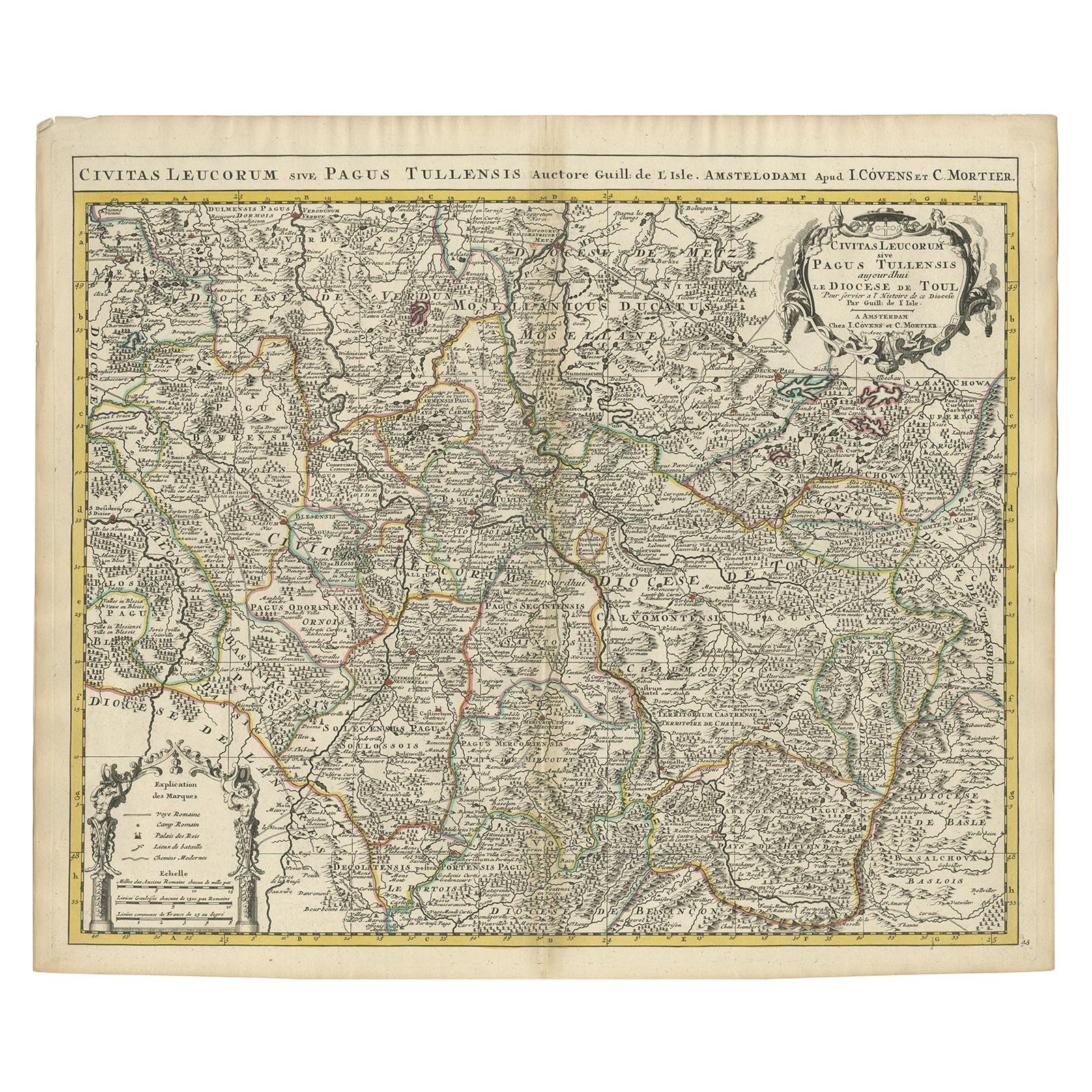
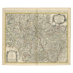
 - Antique Map of the Diocese of Toul by Covens & Mortier, circa 1720By Covens & MortierLocated in Langweer, NLAntique map titled 'Civitas Leucorum sive Pagus Tullensis'. Detailed map of the Diocese of Toul, France. Centered on the cities of Nancy and Toul and including Metz, Verdun, S. Dizie...Category
Antique Early 18th Century Maps
MaterialsPaper
- Antique Map of Western Russia by Covens & Mortier, 1740Located in Langweer, NLAntique map titled 'Carte de Moscovie'. Antique map of the western portion of Russia. The map centers on Moscow (shown near the top of the lower sheet) and spans from the Sea of Azov...Category
Antique Mid-18th Century Maps
MaterialsPaper
 $834 Sale Price20% Off
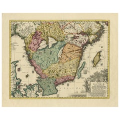
 - Antique Map of Southern Sweden by Covens & Mortier, 'circa 1720'Located in Langweer, NLAntique map titled 'Regni Gothiae (..)'. Detailed map of South Sweden. Embellished with beautiful title cartouche with scale and coats of arms. Published in Amsterdam by Covens & Mor...Category
Antique Early 18th Century Maps
MaterialsPaper
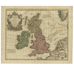
- Antique Map of the British Isles by Covens & Mortier, 1730By Covens & MortierLocated in Langweer, NLCovens and Mortier's attractive double-page engraved map of the British Isles, based on the 1702 De L'Isle map. The map features a large car...Category
Antique Mid-18th Century Maps
MaterialsPaper
 $536 Sale Price24% Off
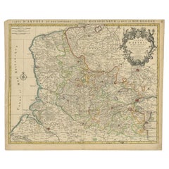
 - Antique Map of the Region of Artois by Covens & Mortier, c.1730By Covens & MortierLocated in Langweer, NLAntique map titled 'Carte d'Artois et des environs'. Large map of the region of Artois, France. Artois is former province located in the northwestern part of France, boarding Belgium...Category
Antique 18th Century Maps
MaterialsPaper
You May Also Like
- Antique Map of Italy by Andriveau-Goujon, 1843By Andriveau-GoujonLocated in New York, NYAntique Map of Italy by Andriveau-Goujon, 1843. Map of Italy in two parts by Andriveau-Goujon for the Library of Prince Carini at Palazzo Carini i...Category
Antique 1840s French Maps
MaterialsLinen, Paper
 $3,350 / set
 - Antique Map of Principality of MonacoBy Antonio Vallardi EditoreLocated in Alessandria, PiemonteST/619 - "Old Geographical Atlas of Italy - Topographic map of ex-Principality of Monaco" - ediz Vallardi - Milano - A somewhat special edition ---Category
Antique Late 19th Century Italian Other Prints
MaterialsPaper
 $228 Sale Price74% Off
 - Original Antique Map of Russia By Arrowsmith. 1820Located in St Annes, LancashireGreat map of Russia Drawn under the direction of Arrowsmith Copper-plate engraving Published by Longman, Hurst, Rees, Orme and Brown, 1820 Unframed.Category
Antique 1820s English Maps
MaterialsPaper

- Original Antique Map of Sweden, Engraved by Barlow, 1806Located in St Annes, LancashireGreat map of Sweden Copper-plate engraving by Barlow Published by Brightly & Kinnersly, Bungay, Suffolk. 1806 Unframed.Category
Antique Early 1800s English Maps
MaterialsPaper
- Original Antique Map of Belgium by Tallis, Circa 1850Located in St Annes, LancashireGreat map of Belgium Steel engraving Many lovely vignettes Published by London Printing & Publishing Co. ( Formerly Tallis ), C.1850 Origin...Category
Antique 1850s English Maps
MaterialsPaper
- Original Antique Map of China by Thomas Clerk, 1817Located in St Annes, LancashireGreat map of China Copper-plate engraving Drawn and engraved by Thomas Clerk, Edinburgh. Published by Mackenzie And Dent, 1817 Unframed.Category
Antique 1810s English Maps
MaterialsPaper


Recently Viewed
View AllMore Ways To Browse
Antique Map Switzerland
Antique Map Of Switzerland
Lake Leman Geneva
Covens & Mortier On Sale
Bag With Map
Bonne Map
Antique Map Ireland
Antique Map Of Ireland
Antique Maps Of Ireland
George Fleet
Antique Irish Maps
Antique Maps Ireland
New Zealand Map
Antique Ireland Map
Antique Irish Map
South Pole
Antique Ireland Maps
Antique Railroad Maps