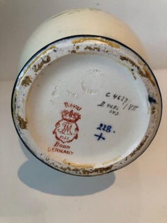
Bonne Map

1
to
22
153
5
150
148
80
38
14
9
5
5
3
3
2
2
2
2
1
1
1
1
1
13
1
1
1
Sort By
1771 Bonne Map of Poitou, Touraine and Anjou, France, Ric.a015
Located in Norton, MA
1771 Bonne Map of Poitou, Touraine and Anjou, France Ric.a015 1771 Bonne map of Potiou
Category

Antique 17th Century Unknown Maps

Materials

Paper

Antique Map of the Empire of China by Bonne, c.1780
By Rigobert Bonne
Located in Langweer, NL
some of the most detailed and accurate maps of the period. Bonne's work represents an important step in
Category

Antique 18th Century Maps

Materials

Paper

Original Antique Map of Martinique Island In The West Indies by Bonne, circa1780
Located in Langweer, NL
. Working in his official capacity Bonne compiled some of the most detailed and accurate maps of the period
Category

Antique 18th Century Maps

Materials

Paper

Antique Map of Northern Brazil by Bonne, c.1780
Located in Langweer, NL
detailed and accurate maps of the period. Bonne's work represents an important step in the evolution of the
Category

Antique 18th Century Maps

Materials

Paper

Bonne, Map of Middle East, Persia, Red Sea, Egypt, Nubia Hand Coloured
Located in Norwich, GB
cartographic documents in Paris, Bonne was able to compile maps containing some of the most up-to-date
Category

Antique 1780s French Prints

Materials

Paper

Antique Map of Part of Southern Asia by Bonne, c.1780
Located in Langweer, NL
capacity Bonne compiled some of the most detailed and accurate maps of the period. Bonne's work represents
Category

Antique 18th Century Maps

Materials

Paper

Antique Map of Northern Europe by Bonne, c.1780
Located in Langweer, NL
compiled some of the most detailed and accurate maps of the period. Bonne's work represents an important
Category

Antique 18th Century Maps

Materials

Paper

Antique Map of Southern Brazil and Uruguay by Bonne, c.1780
Located in Langweer, NL
accurate maps of the period. Bonne's work represents an important step in the evolution of the cartographic
Category

Antique 18th Century Maps

Materials

Paper

Antique Map of Picardy, Aroits and French Flanders by Bonne, c.1780
Located in Langweer, NL
Boulenois.' An attractive example of Rigobert Bonne's 1771 decorative map of the French regions of Picardy
Category

Antique 18th Century Maps

Materials

Paper

Decorative Map of the Empire of China, Korea, Japan, Taiwan, Lucon, Macau, 1780
Located in Langweer, NL
some of the most detailed and accurate maps of the period. Bonne's work represents an important step in
Category

Antique 1780s Maps

Materials

Paper

Antique Map of Mozambique Channel with Madagascar and Inset of Cape Region, 1780
Located in Langweer, NL
. Working in his official capacity Bonne compiled some of the most detailed and accurate maps of the period
Category

Antique 18th Century Maps

Materials

Paper

Antique Map of part of Central and Southern Asia
Located in Langweer, NL
. Working in his official capacity Bonne compiled some of the most detailed and accurate maps of the period
Category

Antique Late 18th Century Maps

Materials

Paper

Copper Engraved Map of Tierra del Fuego and the Strait of Magellan, c1780
Located in Langweer, NL
compiled some of the most detailed and accurate maps of the period. Bonne's work represents an important
Category

Antique 1780s Maps

Materials

Paper

Antique Map of Italy, Corsica, Sardinia and Sicily, ca.1780
Located in Langweer, NL
accurate maps of the period. Bonne's work represents an important step in the evolution of the cartographic
Category

Antique 1780s Maps

Materials

Paper

Map of the Western Coast of South America from Ecuador into Chili, ca.1780
Located in Langweer, NL
detailed and accurate maps of the period. Bonne's work represents an important step in the evolution of the
Category

Antique 1780s Maps

Materials

Paper

Decorative Rare Map of the French Regions of Isle De France and Orleans, ca.1780
Located in Langweer, NL
(..).' A fine example of Rigobert Bonne's c. 1780 decorative map of the French regions of Isle de France
Category

Antique 1780s Maps

Materials

Paper

Decorative Map of the French Regions of Picardy, Artois & French Flanders, c1780
Located in Langweer, NL
Boulenois.' An attractive example of Rigobert Bonne's 1771 decorative map of the French regions of
Category

Antique 1780s Maps

Materials

Paper

Antique Map of Northern Europe and European Russia, ca.1780
Located in Langweer, NL
compiled some of the most detailed and accurate maps of the period. Bonne's work represents an important
Category

Antique 1780s Maps

Materials

Paper

Original Rare Map of the Holy Land Showing the Twelve Tribes of Israel's, 1782
Located in Langweer, NL
capacity Bonne compiled some of the most detailed and accurate maps of the period. Bonne's work represents
Category

Antique 1780s Maps

Materials

Paper

Antique Map of Guadeloupe with Les Saintes, Grand Bourg and La Désirade, c.1780
Located in Langweer, NL
detailed and accurate maps of the period. Bonne's work represents an important step in the evolution of the
Category

Antique 18th Century Maps

Materials

Paper

Map of Spain & Portugal Incl. the islands of Ibiza, Minorque & Majorque, 1780
Located in Langweer, NL
capacity Bonne compiled some of the most detailed and accurate maps of the period. Bonne's work represents
Category

Antique 1780s Maps

Materials

Paper

Antique Map of South American, The West Indies & Most of Africa, Ca.1775
Located in Langweer, NL
detailed and accurate maps of the period. Bonne's work represents an important step in the evolution of the
Category

Antique 1770s Maps

Materials

Paper

Detailed Antique Map of Santa Domingo, Puerto Rico, Eastern Bahamas, ca. 1780
Located in Langweer, NL
detailed and accurate maps of the period. Bonne's work represents an important step in the evolution of the
Category

Antique 1780s Maps

Materials

Paper

Antique French Engraving of Mexico with Lots of Details, c.1780
Located in Langweer, NL
.' Detailed map of Mexico, the Yucatan and Central America, prepared under the direction of Rigobert Bonne
Category

Antique 18th Century Maps

Materials

Paper

Print of Maps of Islands of the South Pacific, Incl. Pitcairn & Dusky Bay, 1788
Located in Langweer, NL
in his official capacity Bonne compiled some of the most detailed and accurate maps of the period
Category

Antique 1780s Maps

Materials

Paper

Antique Detailed Map of Papua New Guinea and the Regions to the West, ca.1780
Located in Langweer, NL
. Working in his official capacity Bonne compiled some of the most detailed and accurate maps of the period
Category

Antique 1780s Maps

Materials

Paper

Uncommon Old Map of Lapland to Russia and Denmark to Kazan in the South, 1785
Located in Langweer, NL
of Bonne's map of Northern Europe covers the region from Lapland to Russia in the north and Denmark
Category

Antique 1780s Maps

Materials

Paper

Antique Map of Asia, Showing Tradewinds, Silke Route Cities Etc, c.1780
Located in Langweer, NL
capacity Bonne compiled some of the most detailed and accurate maps of the period. Bonne's work represents
Category

Antique 18th Century Maps

Materials

Paper

Antique Map of Africa with Ocean Currents and Other Details, C.1780
Located in Langweer, NL
and accurate maps of the period. Bonne's work represents an important step in the evolution of the
Category

Antique 18th Century Maps

Materials

Paper

Antique Map of Mozambique and Cape of Good Hope with Kingdom Monomotapa, 1780
Located in Langweer, NL
accurate maps of the period. Bonne's work represents an important step in the evolution of the cartographic
Category

Antique 18th Century Maps

Materials

Paper

Old Map of the Great Lakes and Upper Mississippi Valley, Northern America, c1780
Located in Langweer, NL
Antique map titled 'Partie Occidentale du Canada'. A fine example of Rigobert Bonne and
Category

Antique 1780s Maps

Materials

Paper

Old Map of The Mughal Empire and the Indian Peninsula South of the Ganges, 1787
Located in Langweer, NL
." An original authentic map, created by Rigobert Bonne (1727-1794), an influential French cartographer
Category

Antique 1780s Maps

Materials

Paper

Antique Map of the West Coast of Africa, 1771
By Rigobert Bonne
Located in Langweer, NL
Antique map titled 'Carte de la Guinee contenant les Isles du Cap Verd, le Senegal, la Cote de
Category

Antique 18th Century Maps

Materials

Paper

Very Decorative Original Antique Map of the World, Published in France in c.1780
By Rigobert Bonne
Located in Langweer, NL
Antique map titled 'L'Ancien Monde Et Le Nouveau en Deux Hemispheres' - Double hemisphere map of
Category

Antique 18th Century Maps

Materials

Paper

Antique Map of Europe by R. Bonne, 1780
Located in Langweer, NL
A fine example of Rigobert Bonne and Guilleme Raynal’s 1780 map of Europe. Drawn by R. Bonne for G
Category

Antique Late 18th Century Maps

Materials

Paper

Antique Map of Europe by R. Bonne, 1780
H 10.24 in W 15.12 in D 0.02 in
Antique Map of Northern India by Bonne, 1780
Located in Langweer, NL
Antique map titled 'Carte de la partie Supérieure de l'Inde (..)'. A fine example of Rigobert Bonne
Category

Antique 18th Century Maps

Materials

Paper

Antique Map of Southern Brazil by Bonne, c.1780
Located in Langweer, NL
. Working in his official capacity, Bonne compiled some of the most detailed and accurate maps of the period
Category

Antique 18th Century Maps

Materials

Paper

Antique Map of Italy by R. Bonne, circa 1780
Located in Langweer, NL
Beautiful map of Italy, Corsica, Sardinia and Sicily. Highly detailed, showing towns, rivers, some
Category

Antique Late 18th Century Maps

Materials

Paper

Antique Map of Italy by R. Bonne, circa 1780
H 17.13 in W 11.23 in D 0.02 in
Antique Map of the East Indies by Bonne '1776'
Located in Langweer, NL
map originates from 'Atlas Moderne' by Jean Lattre. Published 1776. Drawn by Rigobert Bonne, who was
Category

Antique Late 18th Century Maps

Materials

Paper

Antique Map of the East Indies by Bonne '1776'
H 21.26 in W 14.57 in D 0.02 in
Antique Map of West Africa by R. Bonne, 1780
Located in Langweer, NL
Antique map titled 'Partie Occidentale De L'Ancien Continent Depuis Lisbonne Jusqua La Riviere De
Category

Antique Late 18th Century Maps

Materials

Paper

Antique Map of West Africa by R. Bonne, 1780
H 15.04 in W 10.24 in D 0.02 in
Antique Map of Korea and Southern China by Bonne '1771'
Located in Langweer, NL
). This map originates from 'Atlas Moderne' by Jean Lattre. Drawn by R. Bonne.
Category

Antique Mid-18th Century Maps

Materials

Paper

Antique Map of the Arabian Peninsula by Bonne 'c.1780'
Located in Langweer, NL
Antique map titled 'Carte de l'Arabie, du Golfe Persique, et de la Mer Rouge (..)'. Original
Category

Antique Late 18th Century Maps

Materials

Paper

Antique Map of the Arabian Peninsula by Bonne 'c.1780'
Located in Langweer, NL
Antique map titled 'Carte de l'Arabie, du Golfe Persique, et de la Mer Rouge (..)'. Original
Category

Antique Late 18th Century Maps

Materials

Paper

Antique Map of the Russian Empire by R. Bonne, 1780
Located in Langweer, NL
Antique map titled 'Carte de l'Empire de Russie.' Drawn by R. Bonne for G. Raynal’s Atlas de Toutes
Category

Antique Late 18th Century Maps

Materials

Paper

Antique Map of the Philippines, Taiwan and Surroundings by Bonne '1780'
Located in Langweer, NL
Antique map titled 'Les Isles Philippines, celle de Formose, le Sud de la Chine, les Royaumes de
Category

Antique Late 18th Century Maps

Materials

Paper

Antique Map of Persia, Georgia and Kazakhstan by Bonne, c.1780
Located in Langweer, NL
Antique map titled 'Carte de la Perse, de la Georgie, et de la Tartarie Independante'. Map of
Category

Antique 18th Century Maps

Materials

Paper

Antique Map of the Dutch Antilles 'Caribbean' by R. Bonne, circa 1780
Located in Langweer, NL
Antilles (Caribbean). Published by R. Bonne, circa 1780. The antique map titled 'Kaart van de Antilles' is
Category

Antique Late 18th Century Maps

Materials

Paper

Antique Map of Northern Africa "Barbary Coast" by R. Bonne, circa 1780
Located in Langweer, NL
A fine example of Rigobert Bonne and Guilleme Raynal’s 1780 map of northwestern Africa or the
Category

Antique Late 18th Century Maps

Materials

Paper

Charting the Course of Empire: Bonne's 1770 Masterpiece Maps of the Indian Ocean
Located in Langweer, NL
A voyage through history with an exquisite collection of Rigobert Bonne's 1770 maps, as featured in
Category

Antique 1770s Maps

Materials

Paper

Old Map Guiana, Columbia Venezuela, Andalusia in South America by Bonne, c.1780
Located in Langweer, NL
Antique map titled 'Carte du Nouv. Rme. de Grenade, de la Nou'le Andalousie, et de la Guyane, avec
Category

Antique 18th Century Maps

Materials

Paper

Antique Map of Germany, Bohemia, Hungary and Part of Poland by R. Bonne ‘1780’
Located in Langweer, NL
Antique map titled "L'Allemagne, La Bohême, et la Hongrie avec une partie de la Pologne" by
Category

Antique Late 18th Century Maps

Materials

Paper

Antique Map of the Persian Gulf and Caspian Sea Region by R. Bonne, 1780
Located in Langweer, NL
by R. Bonne for G. Raynal’s Atlas de Toutes les Parties Connues du Globe Terrestre, Dressé pour
Category

Antique Late 18th Century Maps

Materials

Paper

Original Engraving of the West Indies, Gulf of Mexico, Antilles, Caribbean, 1780
Located in Langweer, NL
Rigobert Bonne and G. Raynal's 1780 map of the West Indies, Gulf of Mexico, Antilles, and the
Category

Antique Late 18th Century Maps

Materials

Paper

18th Century Antique Map of the Virgin Islands and Caribbean Inset Maps
Located in Langweer, NL
A fascinating piece of cartographic history! The map, titled "Carte du supplément pour les Isles
Category

Antique Late 18th Century Maps

Materials

Paper

Original Antique Map of Asia
Located in Langweer, NL
Antique map titled 'l'Asie'. Original antique map of Asia. Engraved by André after Bonne. Published
Category

Antique Late 18th Century Maps

Materials

Paper

Original Antique Map of Asia
H 10.04 in W 15.67 in D 0.02 in
Decorative Antique Map of Central Asia
Located in Langweer, NL
, Bonne compiled some of the most detailed and accurate maps of the period - most on an equal-area
Category

Antique Late 18th Century Maps

Materials

Paper

Decorative Antique Map of Central Asia
H 14.57 in W 19.69 in D 0.02 in
Antique Map of Oceania by Hérisson, 1816
Located in Langweer, NL
Antique map titled "Océanie ou cinquième partie du monde". This is an original antique map of
Category

Antique 19th Century Maps

Materials

Paper

Antique Map of Sumatra by Bellin, 1764
Located in Langweer, NL
Antique map Sumatra titled 'Carte de l'Isle de Sumatra'. Old map of Sumatra, Malaysia and the
Category

Antique 18th Century Maps

Materials

Paper

Antique Map of Sumatra by Bellin, 1764
H 12.8 in W 17.13 in D 0 in
Antique Map of the Eastern Mediterranean and the Balkans
Located in Langweer, NL
Antique map titled 'La Turquie d'Europe et celle d'Asie'. Attractive double page map of the Eastern
Category

Antique Late 18th Century Maps

Materials

Paper

Antique Map of Persia, Georgia and Kazakhstan, ca.1780
Located in Langweer, NL
Antique map titled 'Carte de la Perse, de la Georgie, et de la Tartarie Independante'. Map of
Category

Antique 1780s Maps

Materials

Paper

  • 1
Get Updated with New Arrivals
Save "Bonne Map", and we’ll notify you when there are new listings in this category.

Bonne Map For Sale on 1stDibs

With a vast inventory of beautiful furniture at 1stDibs, we’ve got just the bonne map you’re looking for. A bonne map — often made from paper and wood — can elevate any home. Your living room may not be complete without a bonne map — find older editions for sale from the 18th Century and newer versions made as recently as the 18th Century. When you’re browsing for the right bonne map, those designed in Louis XVI styles are of considerable interest.

Finding the Right collectibles-curiosities for You

Antique and vintage collectibles and curiosities can bring whimsy and wonder to any interior. 

Decorating with old scientific instruments, historical memorabilia and vintage musical instruments, as well as other authentic collectibles and curiosities that can be found on 1stDibs, presents an opportunity to create a unique, natural history museum-like atmosphere in your home that can provoke conversation as often as it pays tribute to how far we’ve come in understanding our world. 

And bringing collectibles and curiosities into your space is actually on trend — Wunderkammern, or curiosity cabinets, were all the rage in Europe during the 1500s and continued to have adherents there and in the U.S. in the following centuries. Today, however, they’re experiencing a real surge in popularity and influencing how many interior designers are furnishing and decorating homes — combining contemporary with antique, scientific with tribal, earthly with extraterrestrial, Les Lalanne tables with Flemish tapestries.

The original Wunderkammern were entire rooms filled with objects demonstrating their owners’ worldly knowledge: A proper one included artificiala or preciosa (objets d’art); naturalia (such as skeletons, shells, minerals); exotica (taxidermy or dried plants); and scientifica (scientific instruments), frequently alongside religious relics and ancient artifacts.

Pay tribute to a history of rich and diverse musical traditions that have taken shape all over the world by decorating your home with a collection of antique and vintage musical instruments — with a little help from strong hanging wire or some wall hooks, vintage brass instruments such as a gong, French horn or trumpet can help elevate a home office or complement the efforts you’ve made to ensure a welcoming vibe in your home’s entryway. Bells or antique wind instruments can add provocative metallic contrasts to dark woods as tabletop decorative objects.  

Create an intriguing focal point with Georgian scientific instruments, such as stick barometers with mahogany cases or lacquered brass telescopes. These items stem from an era named for the monarchies of the four King Georges, who ruled England in succession starting in 1714 (plus King William’s reign, which lasted until 1837). Just as there was beautiful jewelry produced during the period that today is coveted by collectors, there is much to be found in the collectibles and curiosities realm too.

Wanderlust, nostalgia and a shared love of good design are contributing factors to certain trends in decorating — just as vintage trunks and luggage have reappeared as furniture or home accents in a bedroom or foyer, decorating with globes, maps or nautical objects is similarly rooted in the allure of travel and a penchant for the stylish finishing touch that collectibles bring to our homes.

Find a wide range of antique and vintage collectibles and curiosities on 1stDibs.

Read More

Pamela Shamshiri Shares the Secrets behind Her First-Ever Book and Its Effortlessly Cool Interiors

The sought-after designer worked with the team at Hoffman Creative to produce a monograph that beautifully showcases some of Studio Shamshiri's most inspiring projects.

Moroccan Artworks and Objects Take Center Stage in an Extraordinary Villa in Tangier

Italian writer and collector Umberto Pasti opens the doors to his remarkable cave of wonders in North Africa.

Montecito Has Drawn Royalty and Celebrities, and These Homes Are Proof of Its Allure

Hollywood A-listers, ex-pat aristocrats and art collectors and style setters of all stripes appreciate the allure of the coastal California hamlet — much on our minds after recent winter floods.

Whaam! Blam! Pow! — a New Book on Pop Art Packs a Punch

Publishing house Assouline and writer Julie Belcove have teamed up to trace the history of the genre, from Roy Lichtenstein, Andy Warhol and Yayoi Kusama to Mickalene Thomas and Jeff Koons.

The Sparkling Legacy of Tiffany & Co. Explained, One Jewel at a Time

A gorgeous new book celebrates — and memorializes — the iconic jeweler’s rich heritage.

What Makes a Gem-Encrusted Chess Set Worth $4 Million?

The world’s most opulent chess set, weighing in at 513 carats, is literally fit for a king and queen.

Tauba Auerbach’s Geometric Pop-Up Book Is Mighty Rare, Thanks to a Hurricane

This sculptural art book has an epic backstory of its own.

Step inside the Storied Mansions of Palm Beach’s Most Effervescent Architect

From Spanish-style courtyards to fanciful fountains, these acclaimed structures abound in surprising and elegant details.