Items Similar to Antique Map of Switzerland by N. Visscher, circa 1690


Want more images or videos?
Request additional images or videos from the seller
1 of 9
Antique Map of Switzerland by N. Visscher, circa 1690
$633.34
$791.6720% Off
£470.74
£588.4320% Off
€532
€66520% Off
CA$874.46
CA$1,093.0820% Off
A$969.72
A$1,212.1420% Off
CHF 509.51
CHF 636.8920% Off
MX$11,848.27
MX$14,810.3420% Off
NOK 6,374.71
NOK 7,968.3820% Off
SEK 5,983.75
SEK 7,479.6920% Off
DKK 4,050.91
DKK 5,063.6420% Off
About the Item
Antique map titled 'Tabula Geogaphica qua Pars Meridionalis sive Superior Rheni, Mosae, et Mosellae (..)'. Published by N. Visscher, Amsterdam, circa 1690. Contemporary coloring.
- Dimensions:Height: 21.03 in (53.4 cm)Width: 24.22 in (61.5 cm)Depth: 0.02 in (0.5 mm)
- Materials and Techniques:
- Period:Late 17th Century
- Date of Manufacture:circa 1690
- Condition:Small hole near 'La Bresse' at the bottom left. Please study image carefully.
- Seller Location:Langweer, NL
- Reference Number:Seller: BG-067911stDibs: LU305439800531
About the Seller
5.0
Recognized Seller
These prestigious sellers are industry leaders and represent the highest echelon for item quality and design.
Platinum Seller
Premium sellers with a 4.7+ rating and 24-hour response times
Established in 2009
1stDibs seller since 2017
2,609 sales on 1stDibs
Typical response time: <1 hour
- ShippingRetrieving quote...Shipping from: Langweer, Netherlands
- Return Policy
Authenticity Guarantee
In the unlikely event there’s an issue with an item’s authenticity, contact us within 1 year for a full refund. DetailsMoney-Back Guarantee
If your item is not as described, is damaged in transit, or does not arrive, contact us within 7 days for a full refund. Details24-Hour Cancellation
You have a 24-hour grace period in which to reconsider your purchase, with no questions asked.Vetted Professional Sellers
Our world-class sellers must adhere to strict standards for service and quality, maintaining the integrity of our listings.Price-Match Guarantee
If you find that a seller listed the same item for a lower price elsewhere, we’ll match it.Trusted Global Delivery
Our best-in-class carrier network provides specialized shipping options worldwide, including custom delivery.More From This Seller
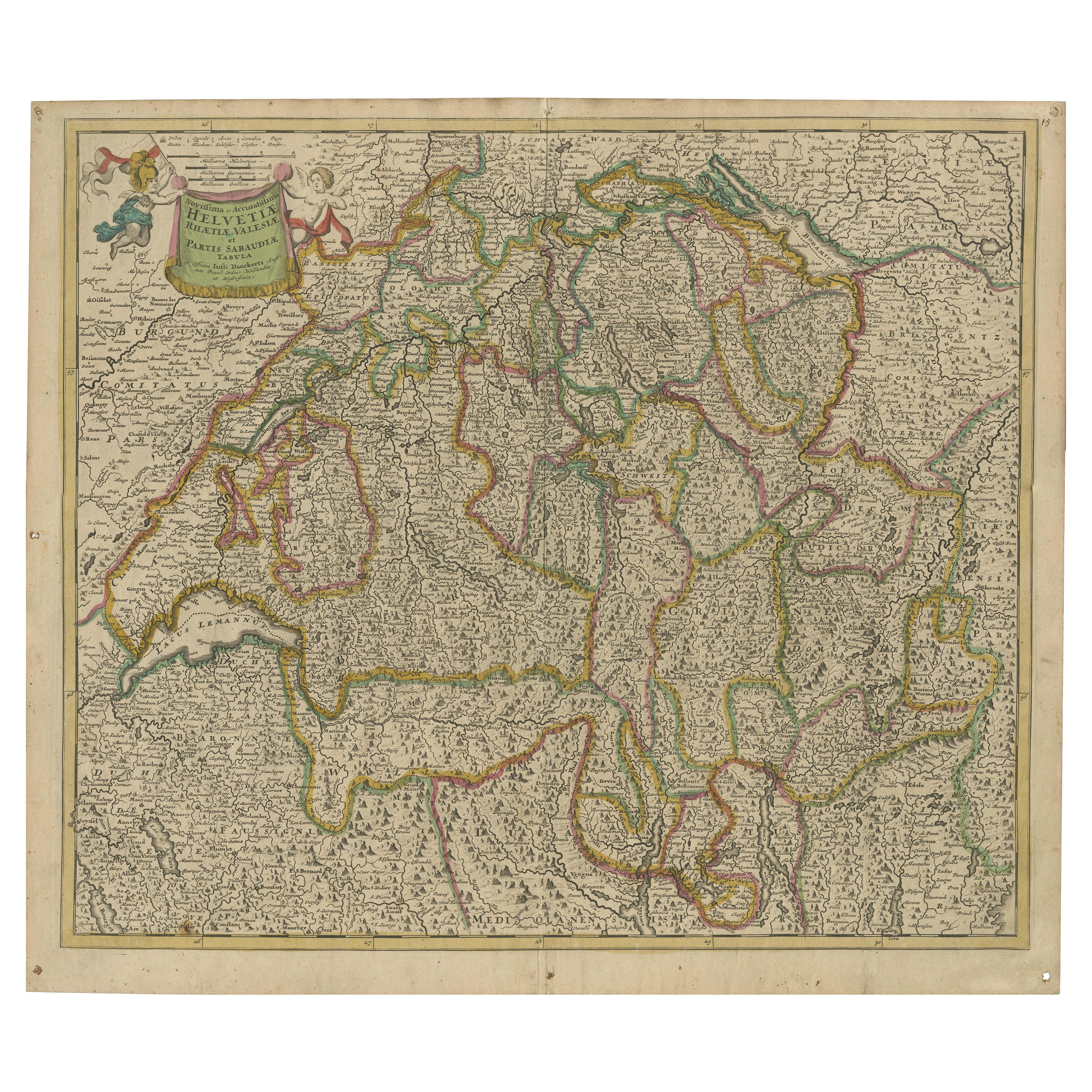
View AllMap of Switzerland by Justus Danckerts, Hand-Colored Engraving ca. 1690
Located in Langweer, NL
Map of Switzerland by Justus Danckerts, Hand-Colored Engraving ca. 1690
This detailed and attractively hand-colored antique map titled *Helvetiae Rhaetiae et Valesiae, nec non parti...
Category
Antique Late 17th Century Maps
Materials
Paper
Antique Map of Switzerland by J.B. Homann, 1751
By Johann Baptist Homann
Located in Langweer, NL
Decorative example of Homann's map of Switzerland, with decorative cartouche and the coat of arms of each of the 13 Cantons.
Category
Antique Mid-18th Century Maps
Materials
Paper

$561 Sale Price
20% Off
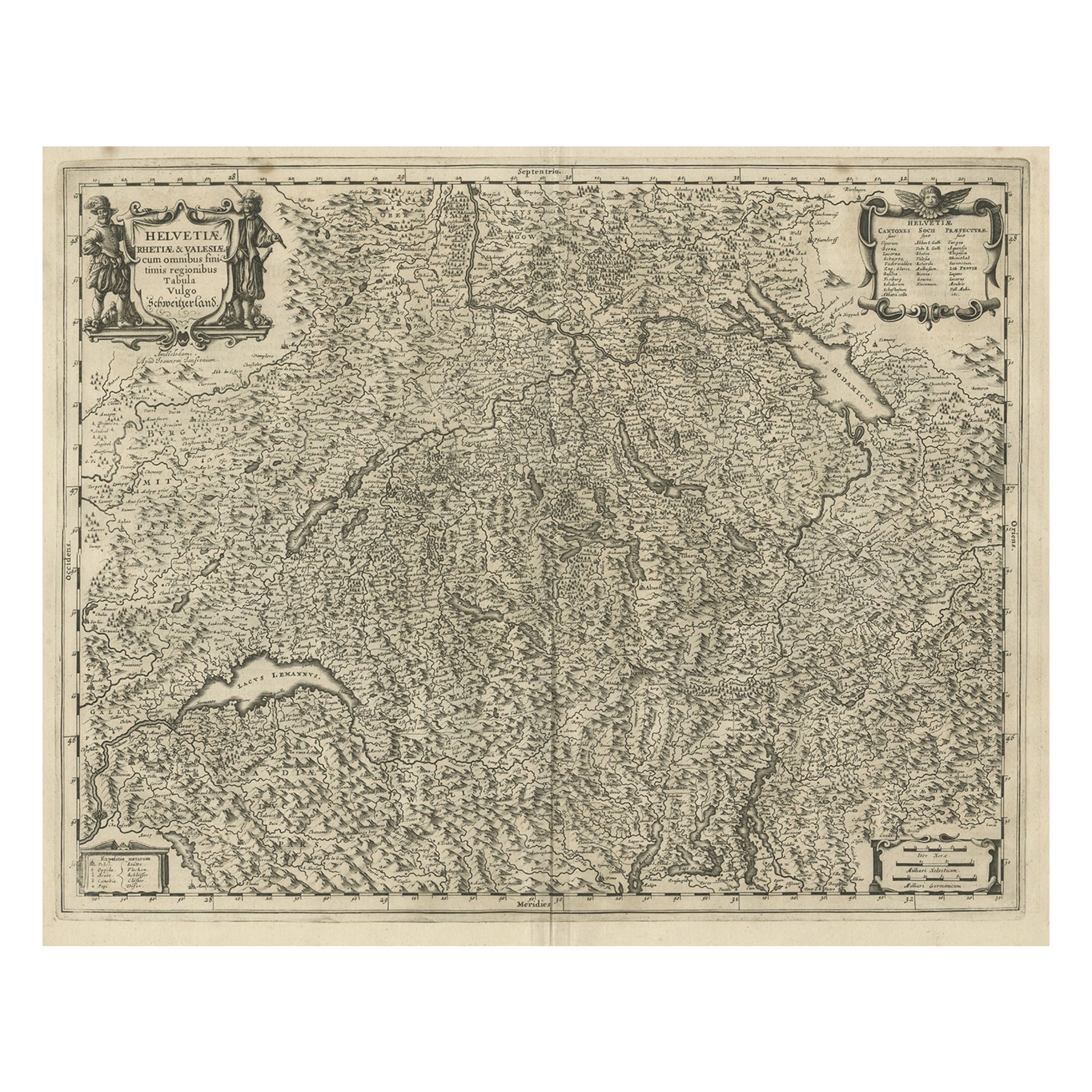
Antique Map of Switzerland by Janssonius, 1657
Located in Langweer, NL
Antique map of Switzerland titled 'Helvetiae Rhetiae & Valesiae'. Decorative and detailed map of Switzerland. This map originates from 'Atla...
Category
Antique 17th Century Maps
Materials
Paper

$499 Sale Price
20% Off
Decorative and Detailed Original Antique Map of Switzerland, 1657
Located in Langweer, NL
Antique map of Switzerland titled 'Helvetiae Rhetiae & Valesiae'.
Decorative and detailed map of Switzerland. This map originates from 'Atlas Novus, Sive Theatrum Orbis Orbis Ter...
Category
Antique 1650s Maps
Materials
Paper
$819 Sale Price
20% Off
Antique Map of Switzerland by Keizer & de Lat, 1788
Located in Langweer, NL
Antique map titled 'La Suisse (..)'. Uncommon original antique map of Switzerland. This map originates from 'Nieuwe Natuur- Geschied- en Handelkundige Zak- en Reisatlas' by Gerrit Br...
Category
Antique Late 18th Century Maps
Materials
Paper

$333 Sale Price
20% Off
Antique Map of Southern Germany by F. de Wit, circa 1680
Located in Langweer, NL
This antique map depicts a portion of southern Germany that included the historic regions of Bavaria, the Palatinate, Prussia-Brandenburg, the Rhineland and Saxony. Regensberg, Freis...
Category
Antique Late 17th Century Maps
Materials
Paper

$661 Sale Price
20% Off
You May Also Like
Original Antique Map of Switzerland, Engraved By Barlow, Dated 1807
Located in St Annes, Lancashire
Great map of Switzerland
Copper-plate engraving by Barlow
Published by Brightly & Kinnersly, Bungay, Suffolk.
Dated 1807
Unframed.
Category
Antique Early 1800s English Maps
Materials
Paper

Map of Switzerland - Etching - 19th Century
Located in Roma, IT
This map of Netherlands is an etching realized in 19th century.
The state of preservation of the artwork is excellent. The signature "F.B." is engraved on the lower right. At the to...
Category
19th Century Figurative Prints
Materials
Etching

West Germany: Original Hand Colored 17th Century Map by Johannes Janssonius
By Johannes Janssonius
Located in Alamo, CA
An original hand colored copperplate engraved map entitled in Latin "Archiepiscopatus Maghdeburgensis et Anhaltinus Ducatus cum terris adjacentibus", published in Amsterdam in 1640 i...
Category
Mid-17th Century Old Masters More Prints
Materials
Engraving

Map of the War -Vesfaglia and Lower Saxony - Etching - 19th Century
Located in Roma, IT
Map of the War -Vestaglia and Lower Saxony is an etching realized during the 19th century.
Good condition.
Category
Early 19th Century Modern Figurative Prints
Materials
Etching

1657 Janssonius Map of Vermandois and Cappelle, Ric. A-004
Located in Norton, MA
1657 Janssonius map of
Vermandois and Cappelle
Ric.a004
Description: Antique map of France titled 'Descriptio Veromanduorum - Gouvernement de la Cappelle'. Two detailed maps o...
Category
Antique 17th Century Unknown Maps
Materials
Paper

Hand Colored 18th Century Homann Map of Austria Including Vienna & the Danube
By Johann Baptist Homann
Located in Alamo, CA
"Archiducatus Austriae inferioris" is a hand colored map of Austria created by Johann Baptist Homann (1663-1724) and published in Nuremberg, Germany in 1728 shortly after his death. ...
Category
Early 18th Century Old Masters Landscape Prints
Materials
Engraving

More Ways To Browse
Carved Cabriole Table
Dark Antique Table
Antique Wall Table
1960 Chair Wood Danish
Unusual Dining Table
Antique Dutch Plates
Mdf Table
Showcase Coffee Table
Space Age Orange
Vallauris France
Silver Ladle
Scalloped Table
Brazil Wood Chairs
Vintage Art Deco Side Tables
Window Display
1960s Cushion Chair
Green Brown Oriental Rug
Authentic Models