Items Similar to Bird’s-Eye View of Basel from Braun & Hogenberg’s Civitates Orbis Terrarum, 1575
Want more images or videos?
Request additional images or videos from the seller
1 of 6
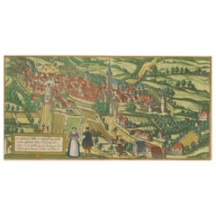
Bird’s-Eye View of Basel from Braun & Hogenberg’s Civitates Orbis Terrarum, 1575
$1,148.13
$1,435.1620% Off
£847
£1,058.7520% Off
€960
€1,20020% Off
CA$1,589.40
CA$1,986.7620% Off
A$1,723.38
A$2,154.2320% Off
CHF 914.58
CHF 1,143.2220% Off
MX$21,225.62
MX$26,532.0220% Off
NOK 11,335.61
NOK 14,169.5120% Off
SEK 10,698.21
SEK 13,372.7620% Off
DKK 7,308.99
DKK 9,136.2420% Off
About the Item
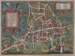
Bird’s-Eye View of Basel from Braun & Hogenberg’s "Civitates Orbis Terrarum" (Circa 1572-1617)
This highly detailed map of Basel is a bird's-eye view, originally based on Sebastian Münster’s map from around 1538, and later incorporated into Braun & Hogenberg's famous city atlas, *Civitates Orbis Terrarum*.
Published between 1572 and 1617, this monumental six-volume collection depicted over 500 towns and cities, providing a glimpse into the urban landscapes of the world during the Renaissance.
Key Features of the Map:
1. Geographical Context:
- Basel is strategically located on a sharp bend of the Rhine River, where Switzerland, France, and Germany meet. The map shows the river as an essential part of the city's daily life, with various boats navigating its waters.
2. City Layout:
- The fortified city is enclosed by defensive walls, with multiple gates and towers guarding its perimeter. Streets, buildings, and fortifications are rendered with great precision, giving a sense of the city's structure and urban density. Basel's famous bridge crossing the Rhine is prominently depicted, illustrating its importance in connecting the two halves of the city.
3. Detailed Buildings and Streets:
- The map provides a remarkable level of detail, showing individual streets, public squares, churches, towers, and homes. The cartographer also included lush gardens and surrounding farmlands, highlighting the city's prosperous and orderly appearance.
4. Economy and Social Life:
- Beyond the architectural details, the map offers a glimpse into Basel's social and economic life. Ships on the river indicate busy trade routes, while activities within and outside the city walls suggest a thriving urban center. The large tents and archery range near the city wall, in the upper right, offer a glimpse into local pastimes and defensive preparations.
5. Legend and Annotations:
- The map includes a legend in the lower-left corner, which labels 27 key buildings and landmarks. This guide helps viewers identify significant structures such as churches, gates, and other important points of interest.
Here is the translation of the legend without bold lettering:
1. Summum templum S. Clarii – The highest church of St. Clarus (Clara Church).
2. Alterum templum et conventus ordinis Praedicatorum – The second church and monastery of the Dominican order.
3. Hospitale – Hospital.
4. Turris ad Pontem – Tower at the bridge.
5. Turris craticulata – Gridded (or latticed) tower.
6. Porta supra Pontem – Gate above the bridge.
7. Suburbium Monachorum Augustinensium – Suburb of the Augustinian monks.
8. Porta nova – New gate.
9. Arx militaris – Military fortress.
10. Templum minore Basilensis civitatis – Minor church of the city of Basel.
11. Gymnasium publicum – Public school (gymnasium).
12. Templum monachorum Augustinensium – Church of the Augustinian monks.
13. Forum civitatis – City marketplace.
14. Domus Praetoria – Town hall (or official's house).
15. Curia senatus – Senate house (or council house).
16. Porta S. Johanis – St. John’s gate.
17. Porta Spallatensis – Spalator Gate.
18. Porta nova orientalis – New eastern gate.
19. Porta Stalportensis – Stalport Gate.
20. Arx militaris Stalportensis – Military fortress of Stalport.
6. Artistic and Historical Importance:
- Braun & Hogenberg's *Civitates Orbis Terrarum* was one of the first major urban atlases in history, combining detailed geographic information with artistic flair. It was revolutionary in allowing people to explore cities from around the world from the comfort of their homes. The inclusion of local customs, manners, and costumes within the plates adds layers of cultural insight.
- The map reflects both Renaissance humanism and the increasing importance of cities as centers of culture, trade, and governance.
7. Military and Defensive Structures:
- Basel’s fortified walls and towers are a dominant feature of the map. The depiction of the tents and archery range outside the walls also provides an interesting look at the city's military preparations and recreational activities involving archery.
Historical Significance:
This map, created during a time of rising urban importance in Europe, serves as both a practical guide and a work of art. It captures the essence of Basel as a fortified yet bustling city, showcasing not only its architecture but also the people’s way of life. *Civitates Orbis Terrarum* became an important resource for scholars, travelers, and leaders during its time, giving them detailed views of cities across Europe and beyond.
The detailed nature of the map, combined with its artistry, reflects the fascination with geography and urban development in the 16th and 17th centuries.
- Dimensions:Height: 16.15 in (41 cm)Width: 21.26 in (54 cm)Depth: 0 in (0.02 mm)
- Materials and Techniques:Paper,Engraved
- Period:
- Date of Manufacture:1575
- Condition:Condition: Very good to excellent. Sharp printing. Centre fold is as published. Original hand coloured. Lower left and right corners have been chipped. Wide margins. Copper engraving printed on hand-laid paper. Study the scans carefully.
- Seller Location:Langweer, NL
- Reference Number:Seller: BG-13648-21stDibs: LU3054341505882
About the Seller
5.0
Recognized Seller
These prestigious sellers are industry leaders and represent the highest echelon for item quality and design.
Platinum Seller
Premium sellers with a 4.7+ rating and 24-hour response times
Established in 2009
1stDibs seller since 2017
2,620 sales on 1stDibs
Typical response time: <1 hour
- ShippingRetrieving quote...Shipping from: Langweer, Netherlands
- Return Policy
Authenticity Guarantee
In the unlikely event there’s an issue with an item’s authenticity, contact us within 1 year for a full refund. DetailsMoney-Back Guarantee
If your item is not as described, is damaged in transit, or does not arrive, contact us within 7 days for a full refund. Details24-Hour Cancellation
You have a 24-hour grace period in which to reconsider your purchase, with no questions asked.Vetted Professional Sellers
Our world-class sellers must adhere to strict standards for service and quality, maintaining the integrity of our listings.Price-Match Guarantee
If you find that a seller listed the same item for a lower price elsewhere, we’ll match it.Trusted Global Delivery
Our best-in-class carrier network provides specialized shipping options worldwide, including custom delivery.More From This Seller
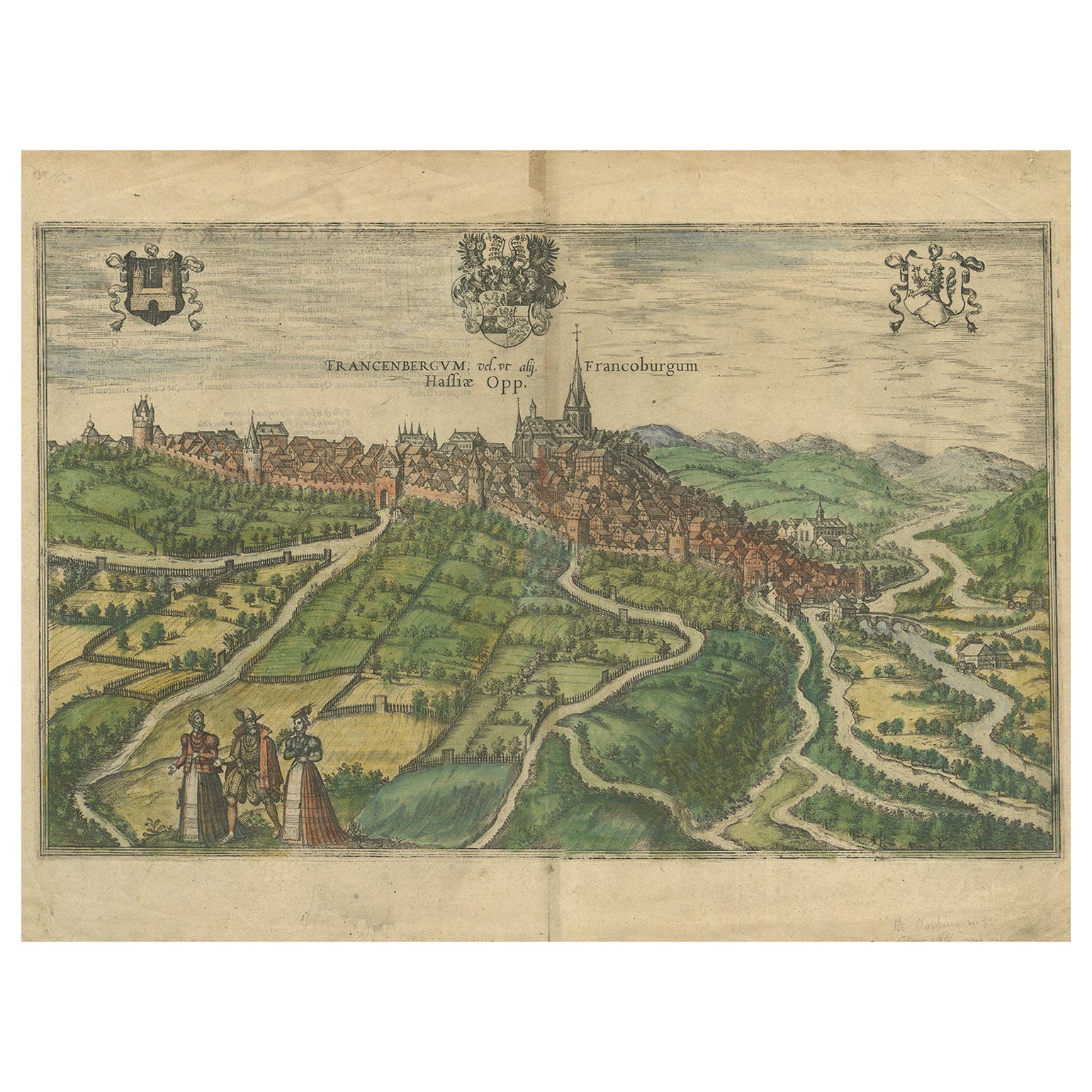
View AllView of Frankenberg: Braun & Hogenberg's Historic Bird's-Eye Map, 1599
Located in Langweer, NL
The antique print titled 'Francenbergum, vel ut alij Francoburgum Hassiae Opp', published by Braun & Hogenberg around 1599, is a remarkable historical ...
Category
Antique 16th Century Prints
Materials
Paper
$477 Sale Price
20% Off
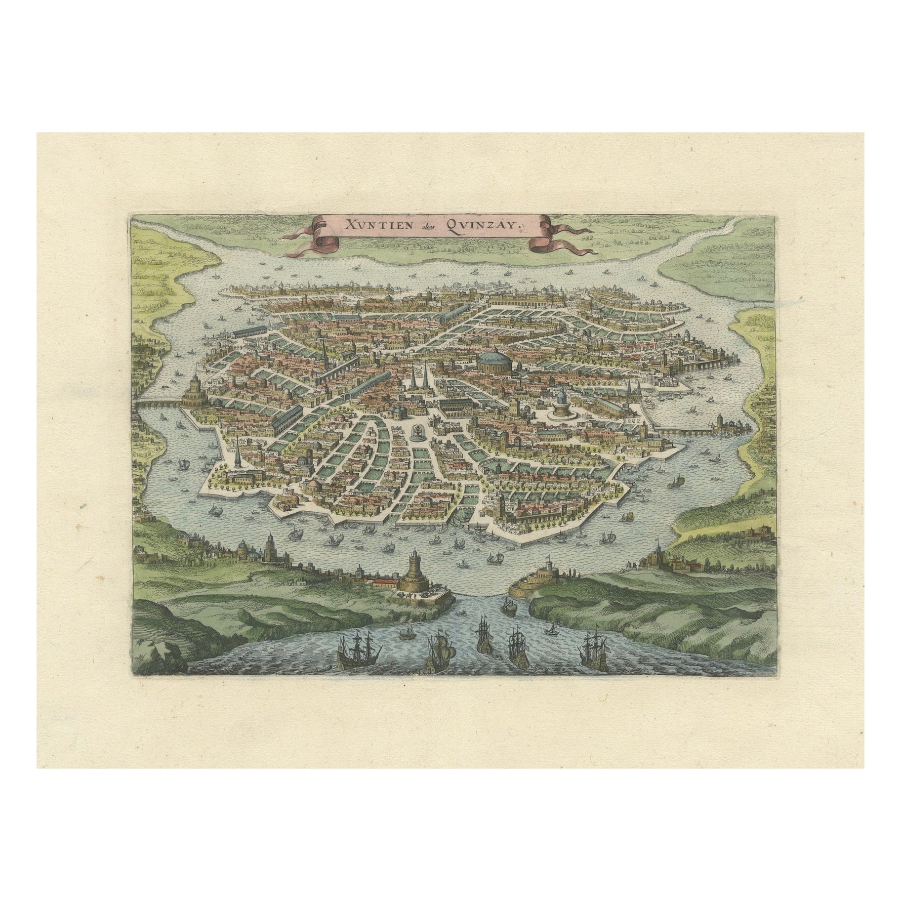
Antique Bird's-Eye View of Hangzhou (China) by Matthäus Merian, 1638
Located in Langweer, NL
This is an exquisite antique bird's-eye view map of Hangzhou, historically referred to as "Xuntien or Quinzay," from the first edition of Matthäus Merian's publication in 1638. This ...
Category
Antique 1630s Maps
Materials
Paper
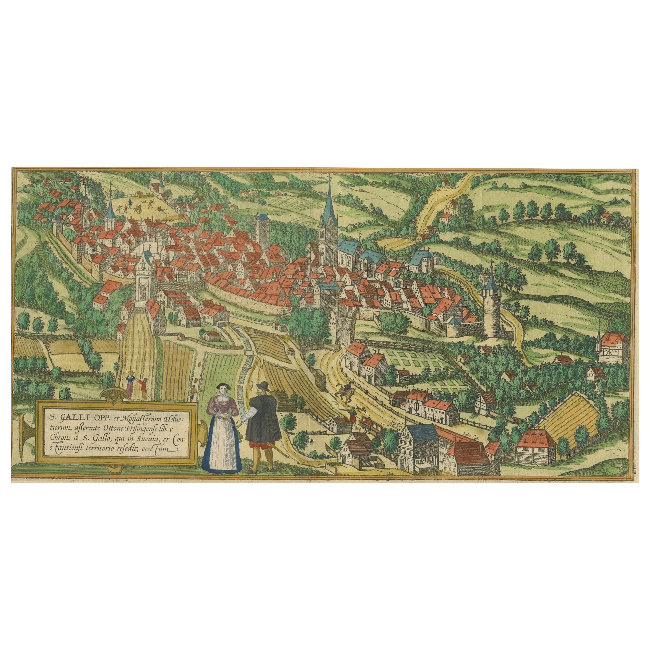
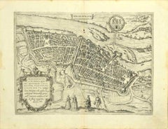
Engraving of St. Gallen and its Monastery, from Civitates Orbis Terrarum (1575)
Located in Langweer, NL
Description of the Engraving: Braun & Hogenberg’s "S. Galli Opp. et Monasterium Heluetiorum" from Civitates Orbis Terrarum (1575)
This is an original, hand-colored copper engraving ...
Category
Antique 16th Century Maps
Materials
Paper
$658 Sale Price
20% Off
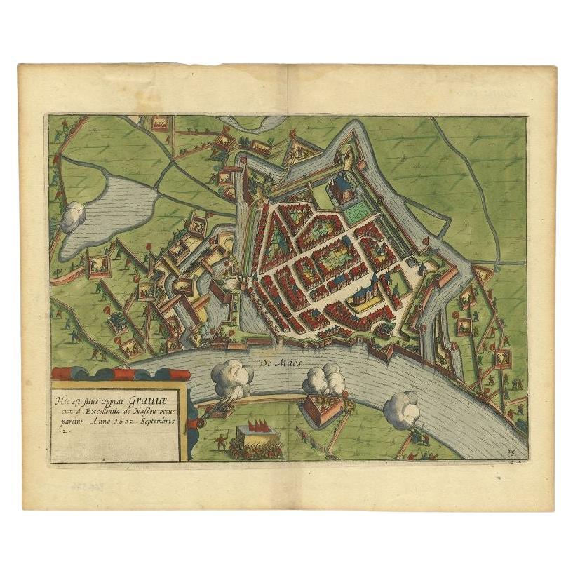
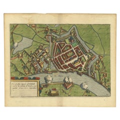
Antique Plan of the Siege of Grave by Guicciardini, c.1608
Located in Langweer, NL
Antique map titled 'Hic est situs oppidi Grauiae (..)'. Bird's eye view plan of Grave, The Netherlands, Holland. Showing the siege of Grave in the year 1602. Source unknown, to be de...
Category
Antique 17th Century Maps
Materials
Paper
$459 Sale Price
20% Off
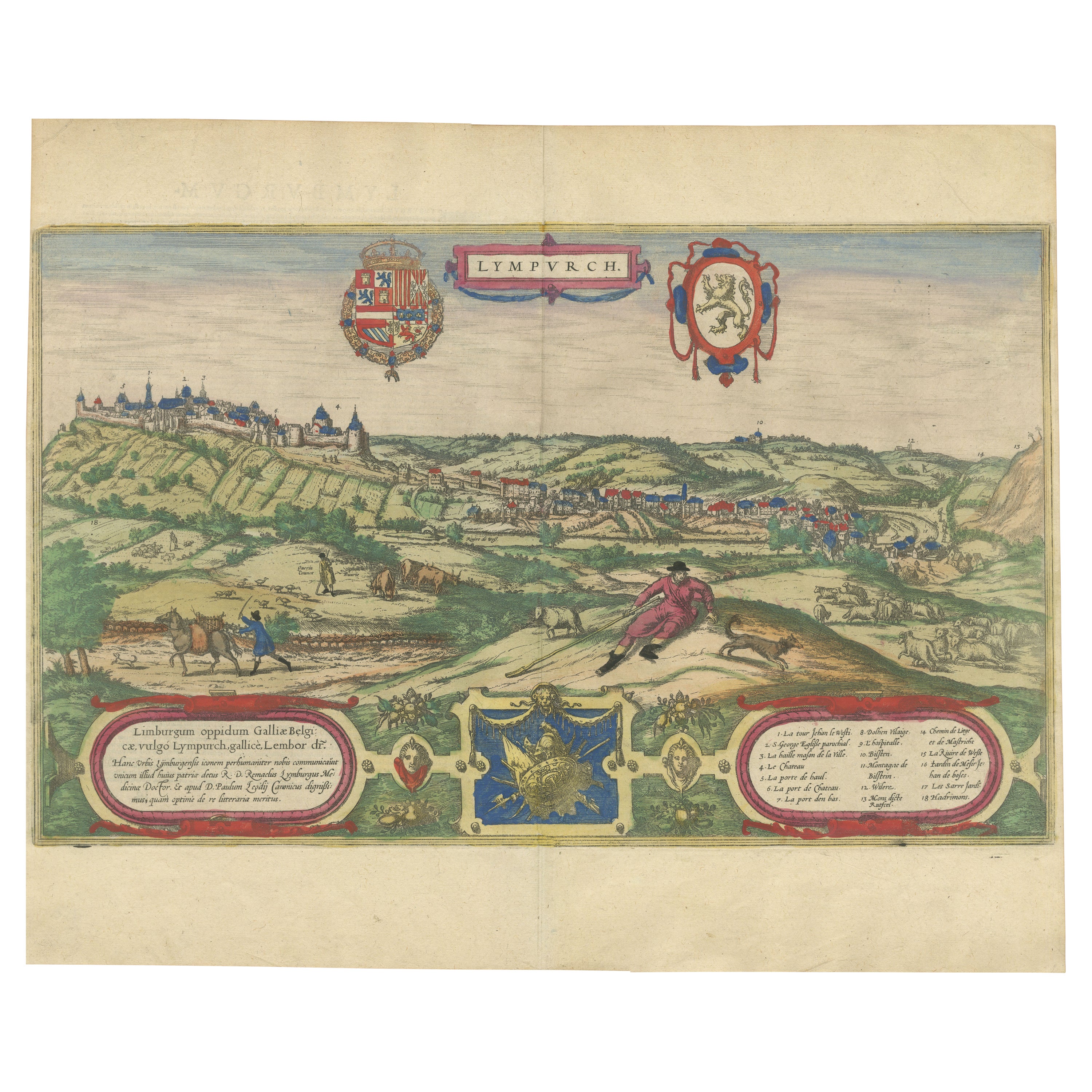
Limburg Cityscape 1580: Historical Copper Engraving by Braun and Hogenberg
Located in Langweer, NL
Title: Limburgum Oppidum Galliae Belgicae, vulgo Lympurch, gallicè, Lembor Dr.
Type: Print (Copper Engraving)
Circa 1580
Technique: Colored Copper Engraving
Medium: Handmade Paper
S...
Category
Antique 16th Century German Maps
Materials
Paper

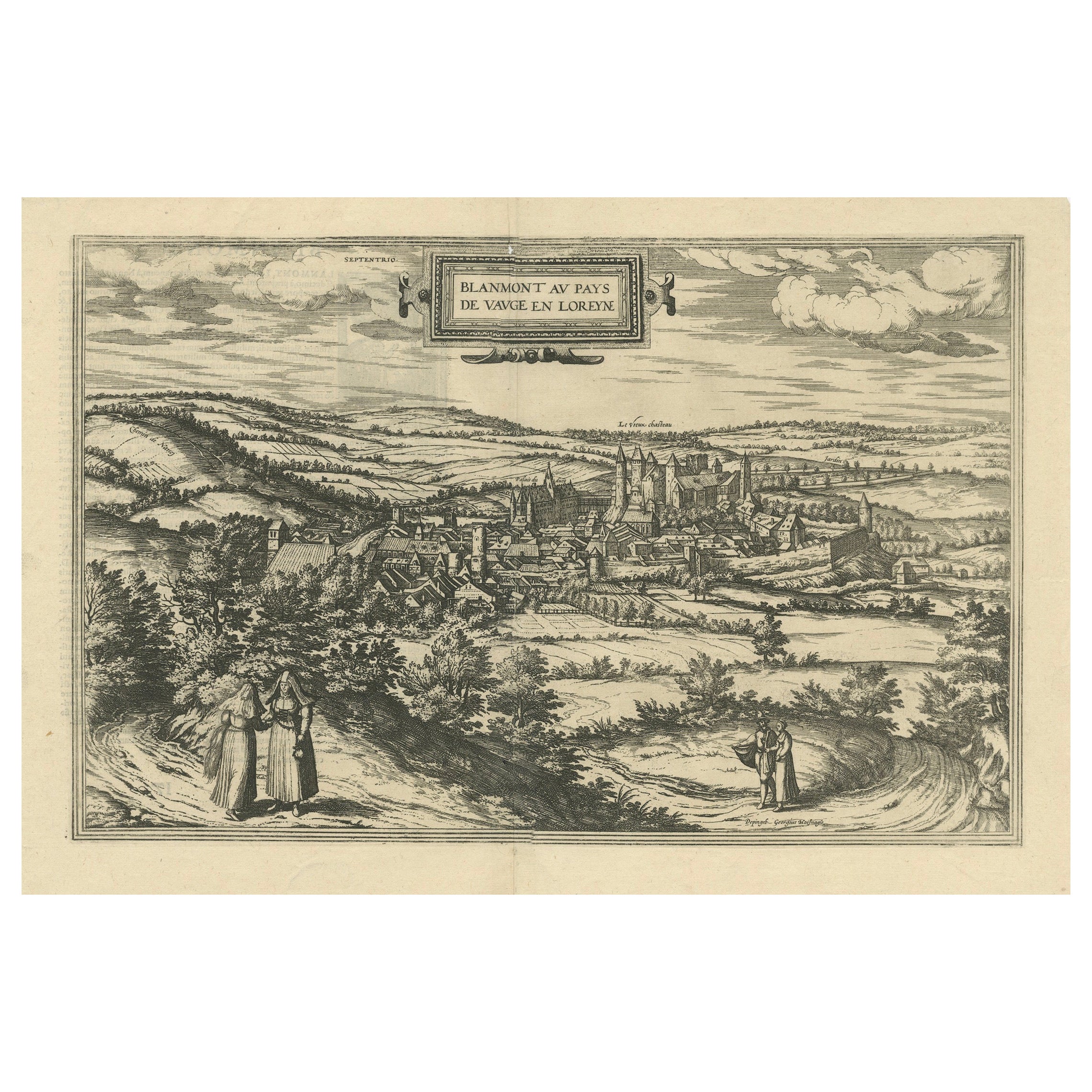
Bird's-Eye View of Blâmont in Lorraine by Braun and Hogenberg, 1597
Located in Langweer, NL
Title: Bird's-Eye View of Blâmont in Lorraine by Braun and Hogenberg, 1597
This copperplate engraving, published in 1597 by Braun and Hogenberg, depicts a bird's-eye view of the t...
Category
Antique 16th Century Maps
Materials
Paper
$401 Sale Price
30% Off
You May Also Like
View of Meissen, Germany: A 16th Century Hand-colored Map by Braun & Hogenberg
By Franz Hogenberg
Located in Alamo, CA
This is a 16th century original hand-colored copperplate engraved map of View of View of Meissen, Germany entitled "Misena Hermun Duvorum Urbs" by Georg Braun & Franz Hogenberg, from their famous city atlas "Civitates Orbis Terrarum", published in Cologne, Germany in 1575.
The map depicts a side view and bird's-eye view, looking across the Elbe River (labelled Albis Fluvius on the map; White River in Latin) from the northeast. In the foreground are three women in conversation on a hill above the city, along with a man and a woman in conversation by a road, all dressed in contemporary costumes of the upper class. A coat-of-arms is present in each upper corner. A great castle sits atop a hill in the background on the left. Meissen grew up around Albrechtsburg castle, built by Emperor Henry I around AD 929, and was granted a municipal charter at the end of the 12th century. From 1471 onwards, the castle complex was reconstructed as the residence of the Saxon electors on the northeast corner of the Domberg (Cathedral Hill). Meissen cathedral is a Gothic hall church begun c. 1270; in 1413 a bolt of lightning destroyed its west towers, which were replaced only in the 20th century. Meissen lies to the northwest of Dresden, Germany in Saxony. Meissen is famous for its Meissen porcelain and the Albrechtsburg castle
The following is an English translation of an excerpt from Braun's description of the city: "This city is surrounded by very many rivers, to the east flows the Elbe, to the south the Triebisch, to the west are the mountains, to the north the Meisse, after which the city is said to be named. The city is well-situated in its surroundings, the navigable rivers, the mountains and the healthy air. Around the city there is a good land to grow grain, fertile vineyards on the hillsides and without doubt the mountains are not without ore, for one mile away, up the Elbe, is Scharfenberg, where silver and lead ore are mined.."
References: Van der Krogt 4, 2684; Taschen, Braun and Hogenberg...
Category
16th Century Old Masters Landscape Prints
Materials
Engraving

Map of Magdeburg - Etching by G. Braun e F. Hogenberg - Late 16th Century
By Franz Hogenberg
Located in Roma, IT
This map of Magdebvrgvm is an original etching realized by George Braun and Frans Hogenberg, as part of the famous series "Civitates Orbis Terrarum" (Atlas of the Cities of the Worl...
Category
16th Century Figurative Prints
Materials
Etching
Map of Cambridge, c.1572 engraving by Braun & Hogenberg
Located in London, GB
To see our other views of Oxford and Cambridge, scroll down to "More from this Seller" and below it click on "See all from this Seller" - or send us a message if you cannot find the ...
Category
16th Century Realist Landscape Prints
Materials
Engraving
Toledo, Map from "Civitates Orbis Terrarum" - by F. Hogenberg - 1575
By Franz Hogenberg
Located in Roma, IT
Braun G., Hogenberg F., "Toledo", from the collection "Civitates Orbis Terrarum", Cologne, T. Graminaeus, 1572-1617. Image Dim: cm 19 x 48 , Dim: cm 22. 5 x 52.5 .
Very nice B/W Aquatint representing a View of Toledo...
Category
16th Century Figurative Prints
Materials
Etching, Aquatint
Munchen, Antique Map from "Civitates Orbis Terrarum" - 1572-1617
By Franz Hogenberg
Located in Roma, IT
Wonderful black and white aquatint showing an antique view of Munchen, capital of Bavaria.
From the collection by Braun G. and Hogenberg F., "Civitates Orbis Terrarum", Cologne, T. ...
Category
16th Century Landscape Prints
Materials
Etching
Map of Wittemberg and Frankfurt- by G. Braun and F. Hogenberg - 16th Century
By Franz Hogenberg
Located in Roma, IT
This Map of Wittemberg and Frankfurt (ancient names: Wittenburga - Francfordiensis) is an original etching realized by George Braun and Franz Hogenberg as part of the famous Atlas "C...
Category
16th Century Modern Figurative Prints
Materials
Etching
More Ways To Browse
Antique Marketplace
Antique Forum
Clara Antique
18th Century Engravings
Antique Carved Wood Chair
Black Scandinavian Modern Dining Chairs
Dutch Mid Century Modern Table
Gold Modern Coffee Table
Iconic Modern Furniture
Midcentury Modern Gray Glass Vase
Round Glass Coffee Tables
Vintage Cave
18th Century Wood Side Tables
Antique Hand Carved Dining Room Sets
Mid Century Modern Pitcher
Vintage Italian Leather Dining Chair
Vintage Movie Posters
Blue Green Wool And Silk Rug