Items Similar to Copper Engraved Grenada Map by John Thompson Published in 1810
Want more images or videos?
Request additional images or videos from the seller
1 of 6
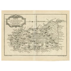
Copper Engraved Grenada Map by John Thompson Published in 1810
$227.63
$284.5420% Off
£170.36
£212.9520% Off
€192
€24020% Off
CA$314.04
CA$392.5520% Off
A$349.23
A$436.5320% Off
CHF 183.42
CHF 229.2820% Off
MX$4,269.65
MX$5,337.0620% Off
NOK 2,285.61
NOK 2,857.0120% Off
SEK 2,154.71
SEK 2,693.3920% Off
DKK 1,461.60
DKK 1,82720% Off
About the Item
John Thomson's original antique map of Grenada, dating back to 1810 and hailing from Edinburgh, stands as a testament to meticulous cartography. This historical piece, adorned with original outline coloring, embodies a significant contribution to the category of Maps West Indies Whole.
Crafted with precision, the map delineates the intricate details of Grenada, capturing the essence of the island during that period. Thomson's expertise shines through in the map's accuracy, presenting geographical features, coastal boundaries, and settlements with meticulous attention.
The use of original outline coloring enriches the map, enhancing the visual appeal while distinguishing various elements across the island. As a part of the broader category of Maps West Indies Whole, this particular map embodies a comprehensive depiction of Grenada within the context of the West Indies.
Thomson's cartographic mastery, evident in this 1810 rendition, reflects an era of exploration and geographical understanding. This antique map of Grenada, originating from Edinburgh, remains a valuable historical artifact, offering insights into the geography and cartographic techniques prevalent during the early 19th century in the West Indies.
Grenada's history weaves a tapestry of indigenous roots, European colonization, and struggles for independence. Initially inhabited by the Kalinago people, European exploration in the late 15th century led to Spanish colonization in the early 16th century. However, ongoing conflicts between European powers resulted in the French seizing control in 1650, establishing sugar plantations and importing enslaved Africans.
The island's strategic importance led to a tug-of-war between the French and British. Grenada changed hands multiple times throughout the 18th century, finally becoming a British colony in 1783 under the Treaty of Versailles. The impact of slavery and the plantation economy shaped Grenada's society and economy.
In 1974, Grenada gained independence from Britain, entering a period of political turbulence. The 1979 revolution led by Maurice Bishop brought hopes for change but was marred by internal strife. In 1983, a power struggle culminated in a U.S.-led military intervention.
Today, Grenada thrives as an independent nation in the Caribbean, known for its stunning landscapes, vibrant culture, and nutmeg production. Its history reflects a complex interplay of indigenous heritage, colonial influences, struggles for self-determination, and efforts to forge a modern identity amid diverse challenges.
- Dimensions:Height: 9.85 in (25 cm)Width: 11.62 in (29.5 cm)Depth: 0.01 in (0.2 mm)
- Materials and Techniques:Paper,Engraved
- Period:
- Date of Manufacture:1810
- Condition:Additions or alterations made to the original: Extended margins on the bottom and right side, support with tape on the reverse. Repaired: One tear repaired in lower left corner with tape on the reverse. Good. A scuffy area in La Grande Baye, but not disturbing. Overal aged related toning. Still an attractive and decorative map with original colors.
- Seller Location:Langweer, NL
- Reference Number:Seller: BG-13618-111stDibs: LU3054337500752
About the Seller
5.0
Recognized Seller
These prestigious sellers are industry leaders and represent the highest echelon for item quality and design.
Platinum Seller
Premium sellers with a 4.7+ rating and 24-hour response times
Established in 2009
1stDibs seller since 2017
2,607 sales on 1stDibs
Typical response time: <1 hour
- ShippingRetrieving quote...Shipping from: Langweer, Netherlands
- Return Policy
Authenticity Guarantee
In the unlikely event there’s an issue with an item’s authenticity, contact us within 1 year for a full refund. DetailsMoney-Back Guarantee
If your item is not as described, is damaged in transit, or does not arrive, contact us within 7 days for a full refund. Details24-Hour Cancellation
You have a 24-hour grace period in which to reconsider your purchase, with no questions asked.Vetted Professional Sellers
Our world-class sellers must adhere to strict standards for service and quality, maintaining the integrity of our listings.Price-Match Guarantee
If you find that a seller listed the same item for a lower price elsewhere, we’ll match it.Trusted Global Delivery
Our best-in-class carrier network provides specialized shipping options worldwide, including custom delivery.More From This Seller
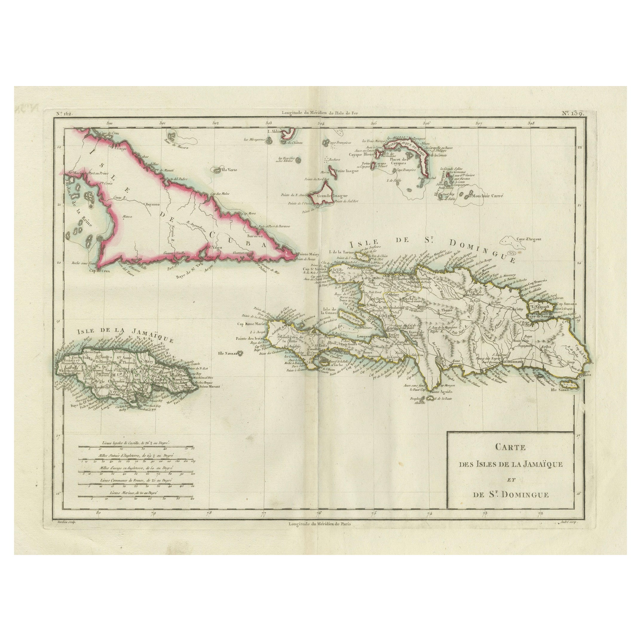
View AllAntique Map of Jamaica and Hispaniola (Saint-Domingue and Santo Domingo), 1802
Located in Langweer, NL
This is an original antique map titled "Carte des Isles de la Jamaïque et de St. Domingue," depicting the islands of Jamaica and Saint-Domingue (modern-day Haiti and the Dominican Re...
Category
Antique Early 1800s Maps
Materials
Paper

$531 Sale Price
20% Off
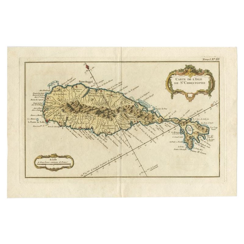
Old Map of the island of Saint Christopher or St. Kitts in the Caribbean, c.1765
Located in Langweer, NL
Antique map titled 'Carte de l'Isle de Saint-Christophe'.
A detailed map of the island of Saint Christopher or St. Kitts showing mountain ranges, port towns and parishes. This map ...
Category
Antique 18th Century Maps
Materials
Paper

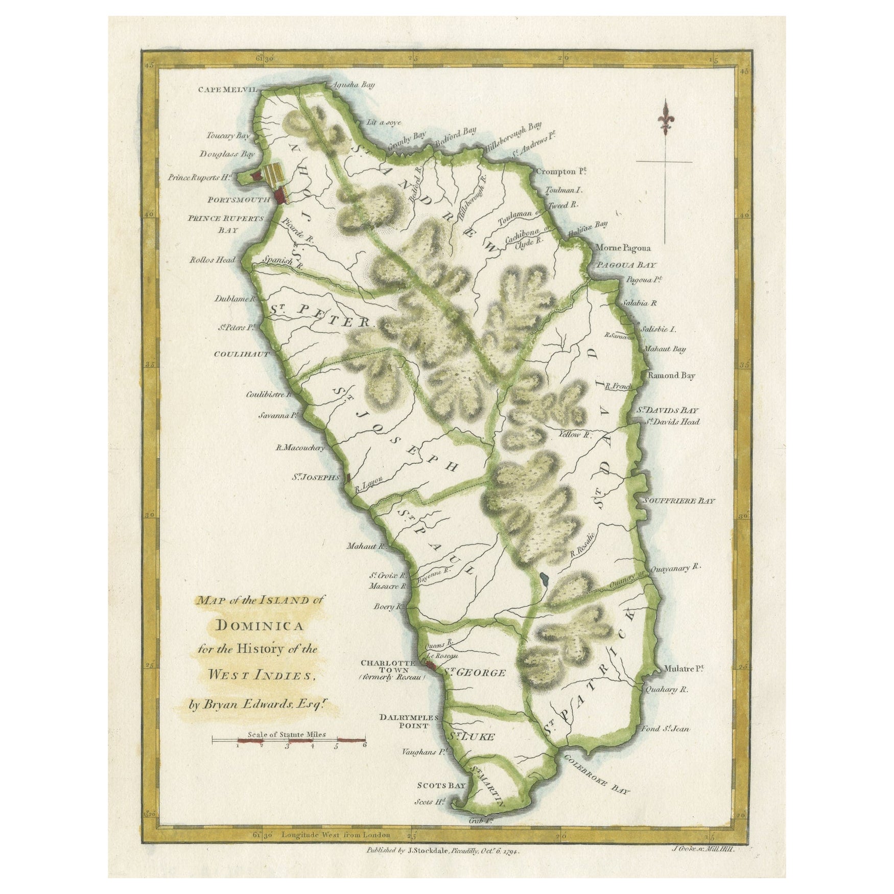
Original Antique Map of the Island of Dominica in the West Indies, 1794
Located in Langweer, NL
MAP OF THE ISLAND OF DOMINICA for the History of the West Indies, by Bryan Edwards. Esq.
Dominica, an island renowned for its lucrative exports of sugar, cocoa, and coffee, operated...
Category
Antique 1790s Maps
Materials
Paper
$227 Sale Price
20% Off
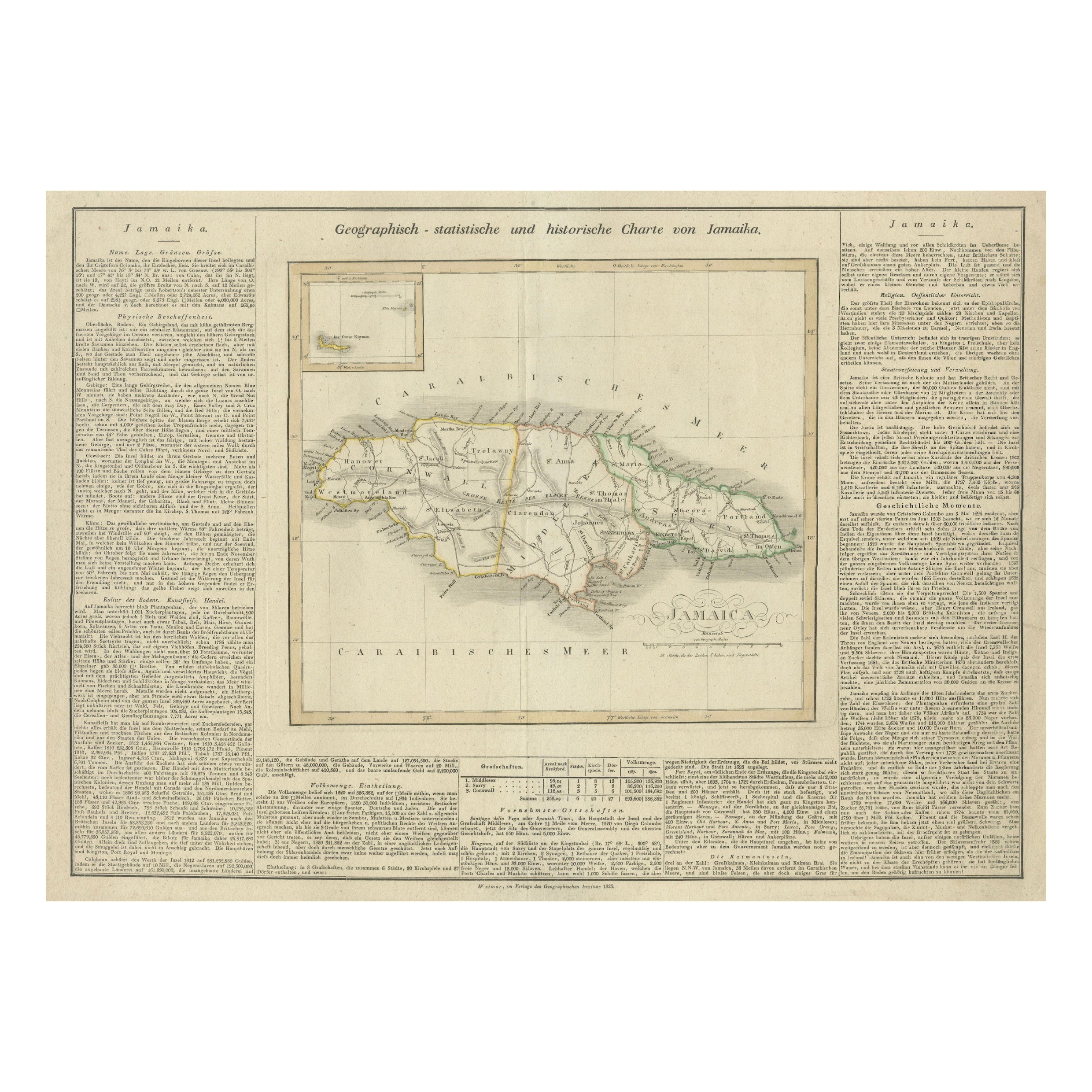
Detailed Antique Map of Jamaica - Published in Weimar, 1825
Located in Langweer, NL
This map of Jamaica is an interesting historical document.
This map is part of an atlas that was issued in six editions in English, French, and German ...
Category
Antique 1820s Maps
Materials
Paper
$512 Sale Price
20% Off
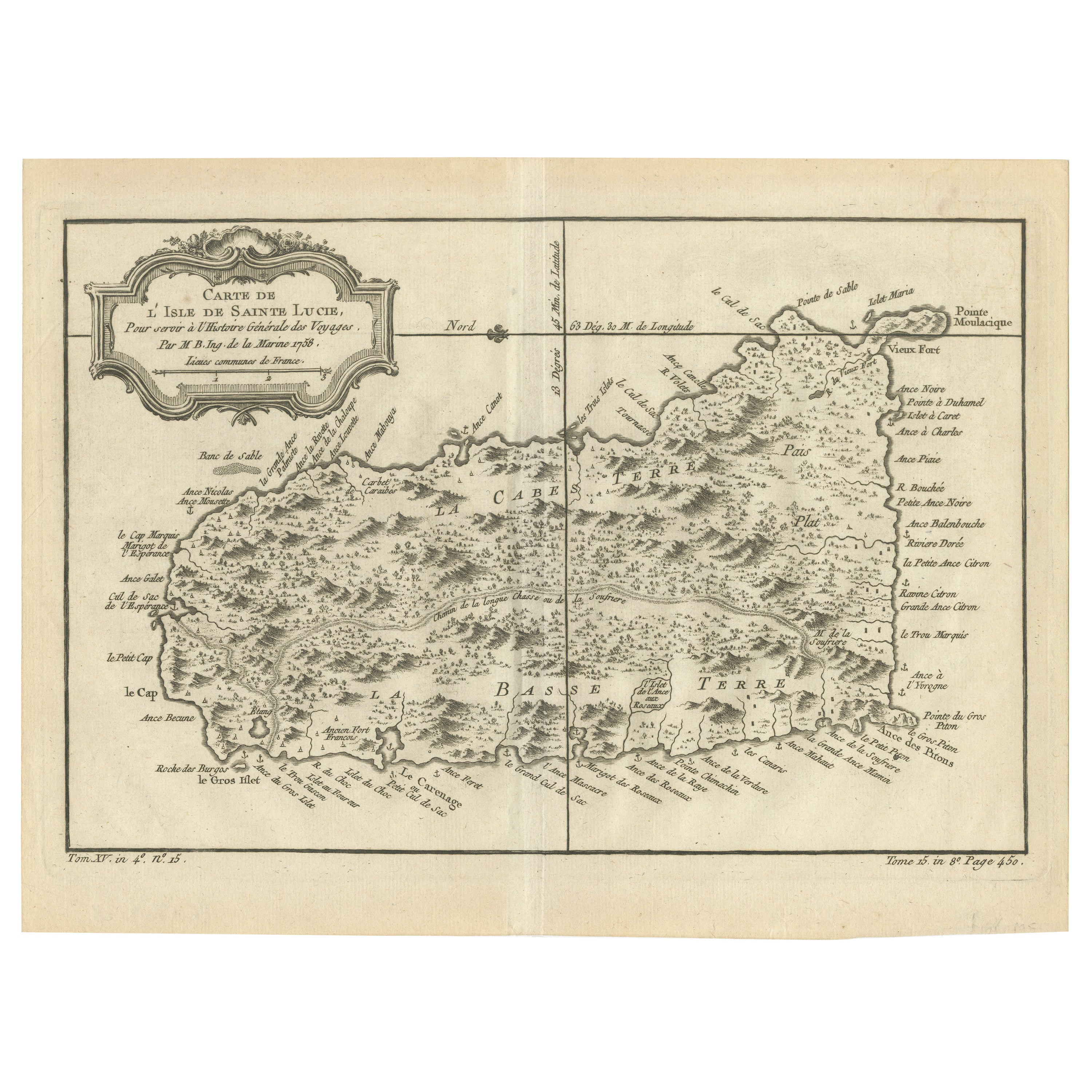
Original Engraved Map of Saint Lucia in the West Indies by Bellin, 1758
Located in Langweer, NL
The "Carte de L’Isle de Sainte Lucie" by Jacques Nicolas Bellin, a prominent figure as the Royal Hydrographer and engineer of the French Navy, is a remarkable antique map showcasing ...
Category
Antique 1750s Maps
Materials
Paper
$322 Sale Price
20% Off
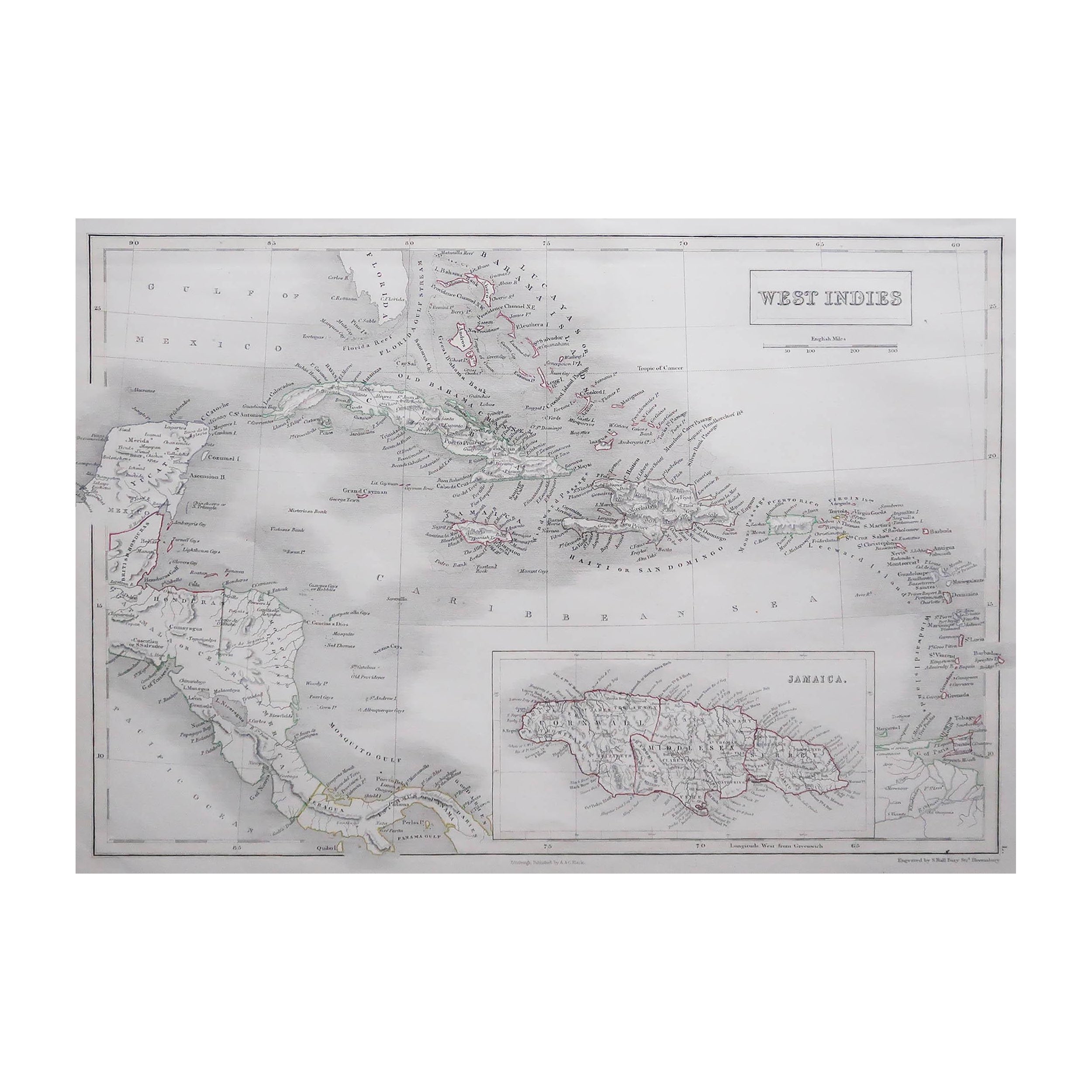
Antique Map of the West Indies and Central America by Lowry '1852'
Located in Langweer, NL
Antique map titled 'West Indies and Central America'. Original map of the West Indies and Central America. This map originates from 'Lowry's Table Atlas constructed and engraved from...
Category
Antique Mid-19th Century Maps
Materials
Paper

$94 Sale Price
20% Off
You May Also Like
Large Original Antique Map of The West Indies by Sidney Hall, 1847
Located in St Annes, Lancashire
Great map of The West Indies
Drawn and engraved by Sidney Hall
Steel engraving
Original colour outline
Published by A & C Black. 1847
Unframed
Free shipping.
Category
Antique 1840s Scottish Maps
Materials
Paper

Map Colonies Francaises Martinique, 1845
Located in BUNGAY, SUFFOLK
Colonies Francaises, Martinique, Amerique DU SUD
Geographie et Statistique par V.Levasseur. Ing'r Geographe.
Illustre par Raymond Bonheur, peintre.
Grave par Laguihermie, Rue St...
Category
Antique 19th Century French Maps
Materials
Paper

Original Antique Map of South America. C.1780
Located in St Annes, Lancashire
Great map of South America
Copper-plate engraving
Published C.1780
Two small worm holes to left side of map
Unframed.
Category
Antique Early 1800s English Georgian Maps
Materials
Paper

Original Antique Map of Central America / Florida, Arrowsmith, 1820
Located in St Annes, Lancashire
Great map of Central America.
Drawn under the direction of Arrowsmith.
Copper-plate engraving.
Published by Longman, Hurst, Rees, Orme and Brown, 1820
Unframed.
Category
Antique 1820s English Maps
Materials
Paper

Large Original Antique Map of The Leeward Islands. 1894
Located in St Annes, Lancashire
Superb Antique map of The Leeward Islands
Published Edward Stanford, Charing Cross, London 1894
Original colour
Good condition
Unframed.
Free shipping
Category
Antique 1890s English Maps
Materials
Paper

Puerto Rico 1910 Original Antique Map Of The Island In A Period Wood Frame
Located in Miami, FL
An antique framed map of Puerto Rico.
Very nice antique map of Puerto Rico printed in a folio of two pages. This map was printed in thin pa...
Category
Antique Early 1900s Puerto Rican American Classical Prints
Materials
Glass, Wood, Paper
$488 Sale Price
30% Off
More Ways To Browse
Thompson Antique
Spanish Copper Antique
15th Century Tapestry
Spanish Antique Weaving
Antique Spanish Tapestry
Antique Plantation Furniture
15th Century French Tapestry
Antique Nutmeg
John Powers
West African Tapestry
Vintage Art Deco Rugs
Vintage Serving Forks
Herati Rug
Italian Wood Console Tables
Maison Jansen Argentina
Antique Oushak
Mid Century Danish Directors Chairs
Moller 70