Items Similar to Cuba Antique Railroad Map c.1888 – The Pearl of the Antilles, Towns


Video Loading
Want more images or videos?
Request additional images or videos from the seller
1 of 12
Cuba Antique Railroad Map c.1888 – The Pearl of the Antilles, Towns
$547.62
£407.03
€460
CA$756.11
A$838.48
CHF 440.56
MX$10,244.75
NOK 5,511.96
SEK 5,173.92
DKK 3,502.67
About the Item
Antique Map of Cuba – Rand McNally, circa 1888
Description:
This antique map of Cuba, published by Rand, McNally & Co. around 1888, presents the island in striking detail during the late colonial period, just a decade before the Spanish–American War would change its history. The map depicts the entire island from Havana in the west to Santiago de Cuba in the east, as well as the Isla de Pinos (today Isla de la Juventud) to the south. On the reverse a colorful map of Alaska - ask for photos when interested)
The island is divided into provinces, each shaded in soft pastel colors (yellow, pink, and green), with clear demarcation of towns, ports, rivers, and roads. Major settlements such as Havana, Matanzas, Cienfuegos, Puerto Príncipe (Camagüey), and Santiago are prominently marked. Maritime detail includes soundings, shoals, and navigation banks surrounding the island, with the Straits of Florida, the Bahamas, and the Caribbean Sea all carefully engraved.
This map reflects the growing interest in the Caribbean during the 19th century, when Cuba was one of Spain’s last remaining colonies in the Americas and a focal point of international trade. Rand McNally’s cartography captures both the geographic richness of the island and the surrounding waters, offering a document of significant historical context.
Condition report:
Very good condition with mild toning and faint center fold as issued. Plate impression visible. Slight handling marks in margins, not affecting image. (needs to be re-scanned - not balanced)
Framing tips:
This map is especially striking when framed with a dark wood or mahogany frame. A cream mat with a subtle warm-toned inner mat enhances the pastel provincial coloring and the engraved detail.
Technique: Lithograph with original outline and wash color
Maker: Rand, McNally & Co., Chicago, circa 1888
- Dimensions:Height: 14.18 in (36 cm)Width: 20.67 in (52.5 cm)Depth: 0.01 in (0.2 mm)
- Materials and Techniques:Paper,Engraved
- Place of Origin:
- Period:
- Date of Manufacture:1888
- Condition:Very good condition with mild toning and faint center fold as issued. Plate impression visible. Slight handling marks in margins, not affecting image.
- Seller Location:Langweer, NL
- Reference Number:Seller: BG-12794-41stDibs: LU3054346476032
About the Seller
5.0
Recognized Seller
These prestigious sellers are industry leaders and represent the highest echelon for item quality and design.
Platinum Seller
Premium sellers with a 4.7+ rating and 24-hour response times
Established in 2009
1stDibs seller since 2017
2,609 sales on 1stDibs
Typical response time: <1 hour
- ShippingRetrieving quote...Shipping from: Langweer, Netherlands
- Return Policy
Authenticity Guarantee
In the unlikely event there’s an issue with an item’s authenticity, contact us within 1 year for a full refund. DetailsMoney-Back Guarantee
If your item is not as described, is damaged in transit, or does not arrive, contact us within 7 days for a full refund. Details24-Hour Cancellation
You have a 24-hour grace period in which to reconsider your purchase, with no questions asked.Vetted Professional Sellers
Our world-class sellers must adhere to strict standards for service and quality, maintaining the integrity of our listings.Price-Match Guarantee
If you find that a seller listed the same item for a lower price elsewhere, we’ll match it.Trusted Global Delivery
Our best-in-class carrier network provides specialized shipping options worldwide, including custom delivery.More From This Seller
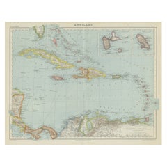
View AllAntique Map of the Antilles and Central America – 1872
Located in Langweer, NL
Title: Antique Map of the Antilles and Central America – 1872
Description:
This finely detailed antique map, titled Antilles et Amérique Centrale, was published in 1872 under t...
Category
Antique 1870s Maps
Materials
Paper

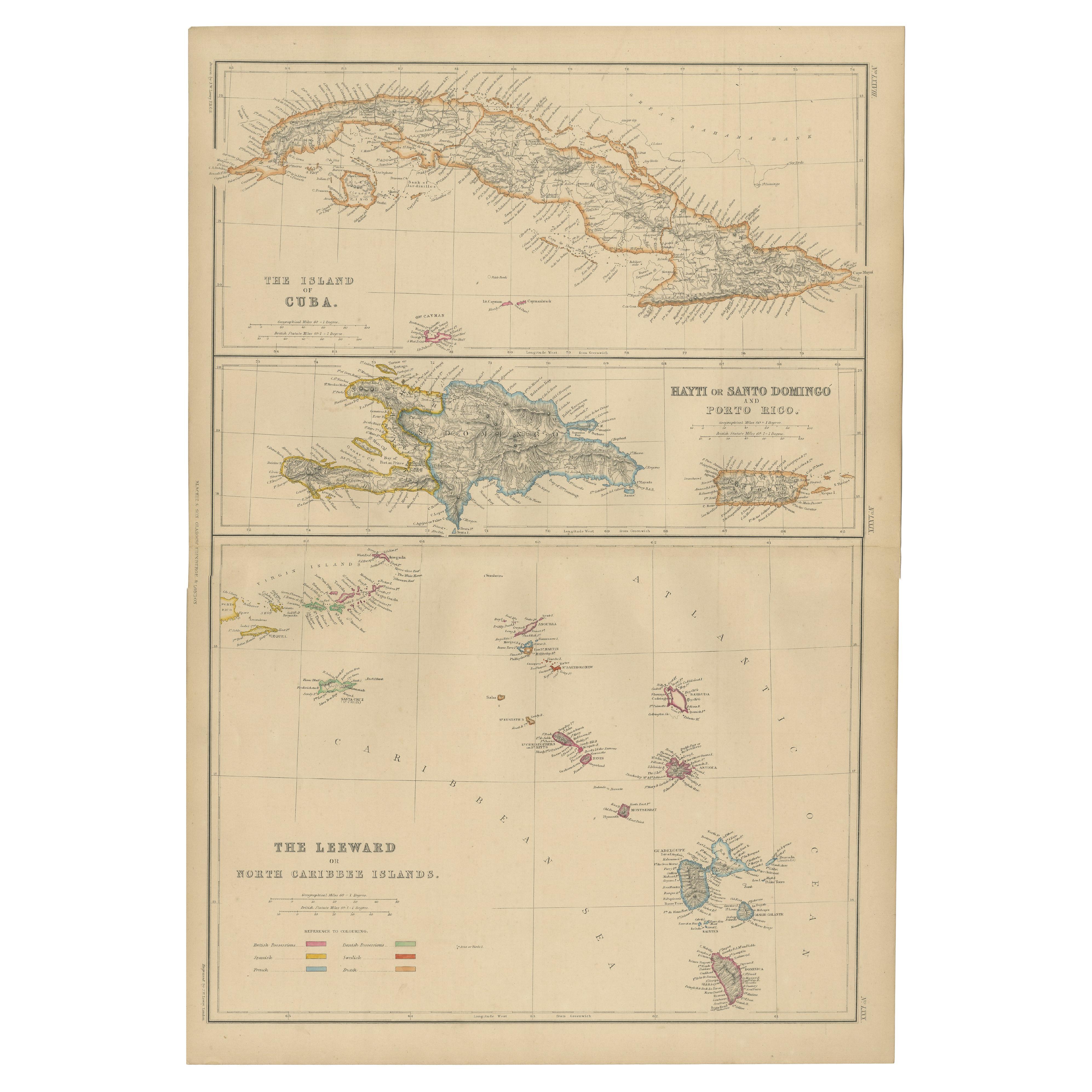
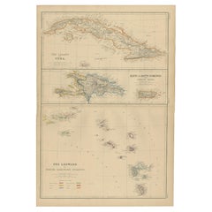
Antique Map of Cuba, Haiti and Porto Rico by W. G. Blackie, 1859
Located in Langweer, NL
Antique map titled 'The Leeward or North Caribbean Islands'. Original antique map of Cuba, Haiti and Porto Rico. This map originates from ‘The Imperial Atla...
Category
Antique Mid-19th Century Maps
Materials
Paper
$239 Sale Price
20% Off
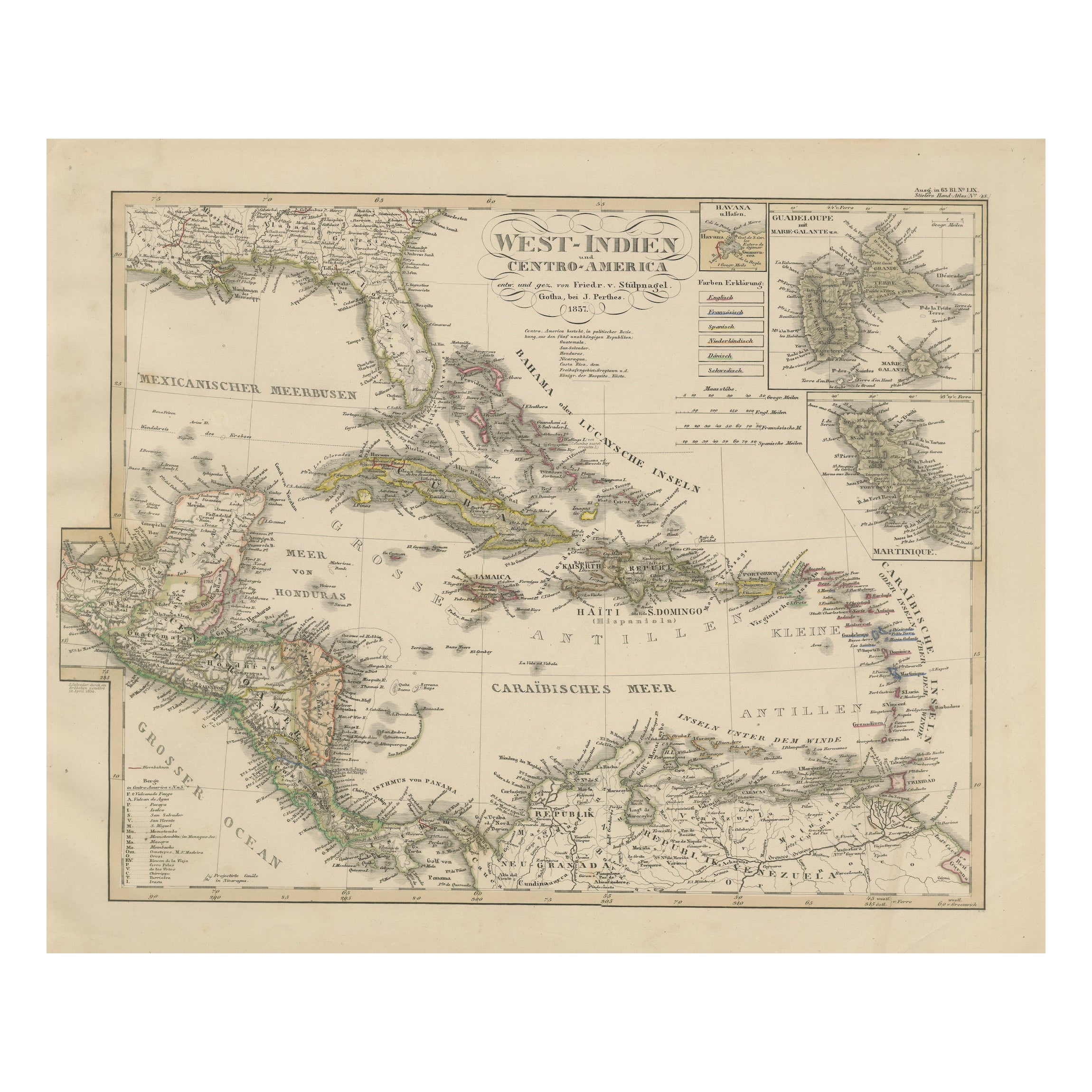
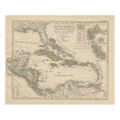
Antique Map of the Caribbean & Central America – West Indies, 1857
Located in Langweer, NL
Antique Map of the Caribbean & Central America – West Indies, 1857
This finely engraved and hand-colored map titled "West-Indien und Centro-America" was published in 1857 by Justus ...
Category
Antique Mid-19th Century German Maps
Materials
Paper
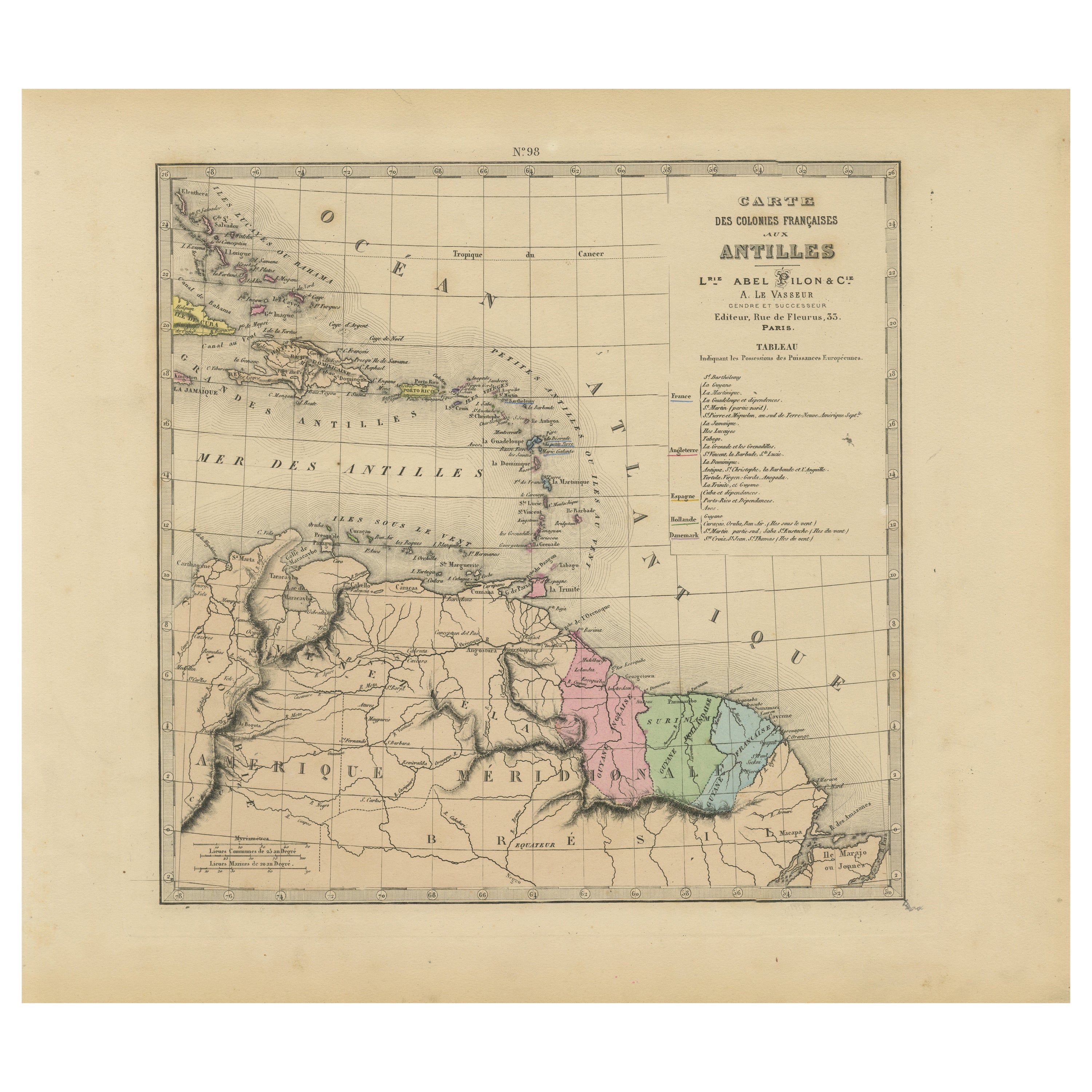
Authentique Map by Pilon of The French Colonies in The West Indies, 1876
Located in Langweer, NL
The 1876 map titled "Carte des Colonies Françaises aux Antilles" represents a significant contribution to cartography within the "Grand Atlas Départemental de la France de L'Algérie ...
Category
Antique Late 19th Century Maps
Materials
Paper
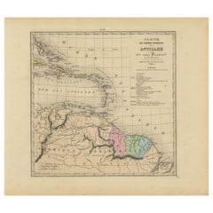
$229 Sale Price
20% Off
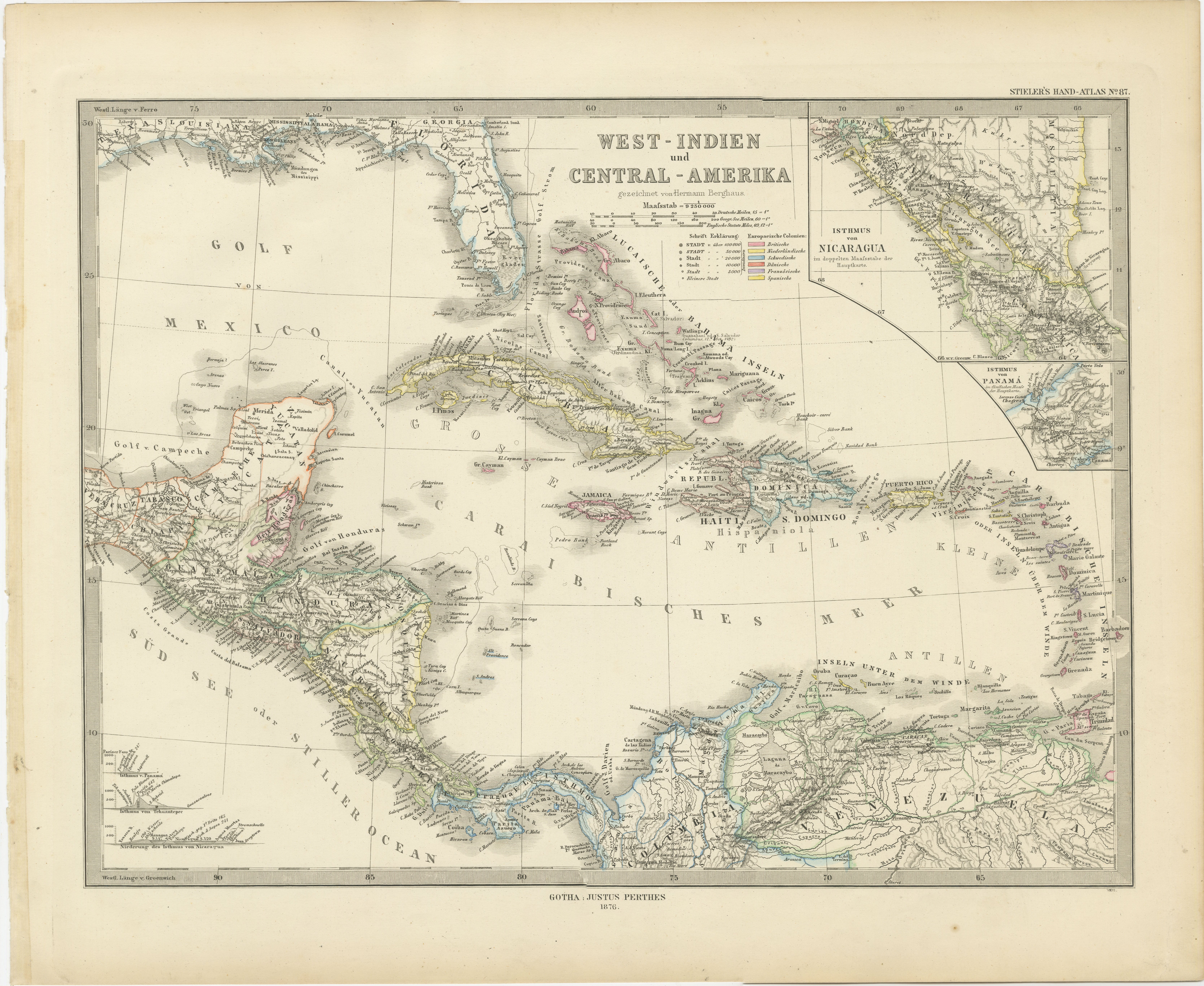
1880 Map of the Caribbean and Central America by Adolf Stieler
Located in Langweer, NL
This is a detailed map titled "West-Indien und Central-Amerika," created by Adolf Stieler and published in Gotha in 1880. The map covers the Caribbean islands and the Central America...
Category
Antique 1880s Maps
Materials
Paper
$277 Sale Price
20% Off
Vintage Map of the Greater Antilles and Lesser Antilles
Located in Langweer, NL
Vintage map titled 'Antilles'. Original map of the Antilles. Shows the Cayman Islands, Cuba, Hispaniola (subdivided into the nations of the Dominican Republic and Haiti), Jamaica, and Puerto Rico. Also shows the Lesser Antilles...
Category
20th Century Maps
Materials
Paper
$133 Sale Price
20% Off
You May Also Like
Original Antique Map of Central America / Florida, Arrowsmith, 1820
Located in St Annes, Lancashire
Great map of Central America.
Drawn under the direction of Arrowsmith.
Copper-plate engraving.
Published by Longman, Hurst, Rees, Orme and Brown, 1820
Unframed.
Category
Antique 1820s English Maps
Materials
Paper

Central America. Century Atlas antique vintage map
Located in Melbourne, Victoria
'The Century Atlas. Central America.'
Original antique map, 1903.
Inset maps of 'The Country around Lake Nicaragua'.
Central fold as issued. Map name and number printed on the reve...
Category
Early 20th Century Victorian More Prints
Materials
Lithograph

South America, Eastern Part. Century Atlas antique vintage map
Located in Melbourne, Victoria
'The Century Atlas. South America. Eastern Part'
Original antique map, 1903.
Inset map 'Rio de Janeiro and Vicinity'.
Central fold as issued. Map name and number printed on the rev...
Category
Early 20th Century Victorian More Prints
Materials
Lithograph

Large Original Antique Map of The West Indies by Sidney Hall, 1847
Located in St Annes, Lancashire
Great map of The West Indies
Drawn and engraved by Sidney Hall
Steel engraving
Original colour outline
Published by A & C Black. 1847
Unframed
Free shipping.
Category
Antique 1840s Scottish Maps
Materials
Paper

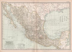
Mexico. Century Atlas antique vintage map
Located in Melbourne, Victoria
'The Century Atlas. Mexico.'
Original antique map, 1903.
Central fold as issued. Map name and number printed on the reverse corners.
Sheet 29.5cm by 40cm.
Category
Early 20th Century Victorian More Prints
Materials
Lithograph
Original Antique Map of The Western Hemisphere by Dower, circa 1835
Located in St Annes, Lancashire
Nice map of the Western Hemisphere
Drawn and engraved by J.Dower
Published by Orr & Smith. C.1835
Unframed.
Free shipping
Category
Antique 1830s English Maps
Materials
Paper
