Items Similar to Detailed German Map of Australia Including Statistics of 1841, Published in 1854

Want more images or videos?
Request additional images or videos from the seller
1 of 6
Detailed German Map of Australia Including Statistics of 1841, Published in 1854
$190.48
$238.1020% Off
£141.58
£176.9720% Off
€160
€20020% Off
CA$263
CA$328.7520% Off
A$291.64
A$364.5520% Off
CHF 153.24
CHF 191.5520% Off
MX$3,563.39
MX$4,454.2420% Off
NOK 1,917.21
NOK 2,396.5120% Off
SEK 1,799.62
SEK 2,249.5320% Off
DKK 1,218.32
DKK 1,522.9020% Off
About the Item
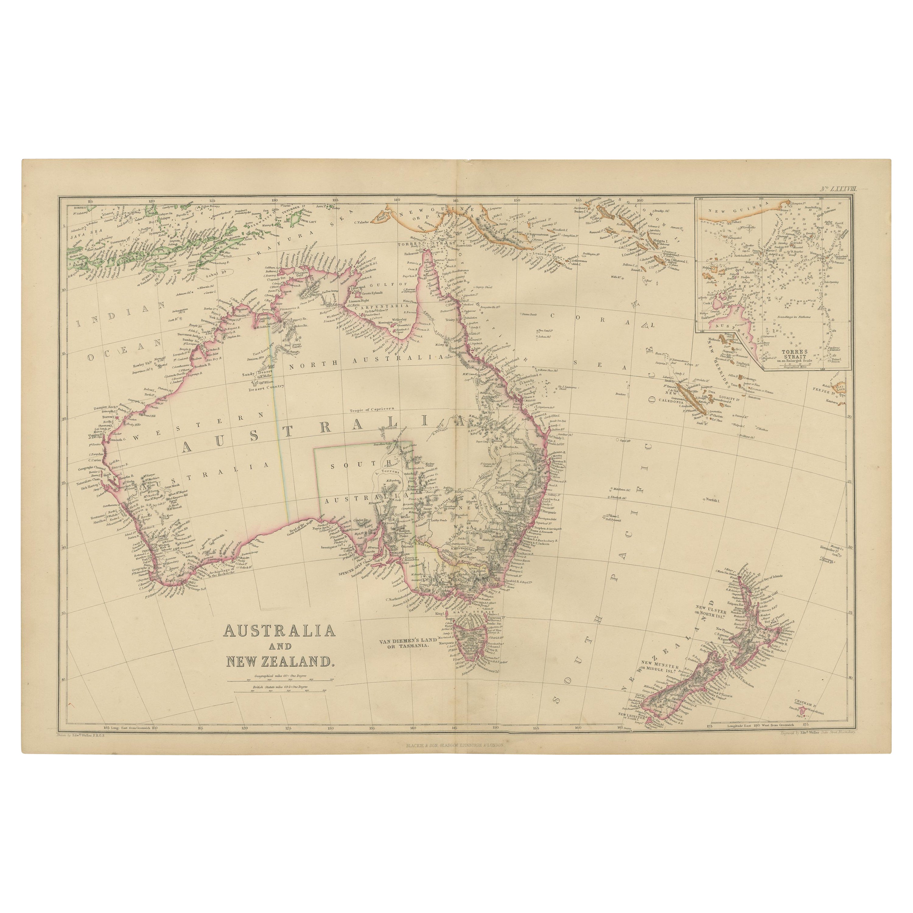
Title: "Detailed Map of Austral Land - 1854"
This historic map, titled "Australland," was published in Glogau in 1854 by cartographer Carl Flemming. It's an intricately detailed depiction of Australia, showcasing the division of colonies, which include New South Wales, West Australia, and Van Diemen's Land (now known as Tasmania). Towns, mountain ranges, rivers, and surrounding islands are meticulously marked, providing a comprehensive view of the mid-19th century Australian landscape.
A key feature of this map is the inclusion of a statistical table that gives a snapshot of the population distribution across the colonies as of 1841. This demographic information provides insight into the human geography of the time.
The map also honors the history of exploration and discovery in Australia, with notes referencing significant explorers such as De Witt, Tasman, and Flinders, among others. It acknowledges their contributions to charting the coastline and interior of the continent. The notes "Entdeckt Durch" followed by an explorer's name means "Discovered By," attributing the discovery of particular regions to these figures.
The cartographic style is indicative of the period, with fine engraving and a simple yet effective color scheme that differentiates land from sea, colonies, and borders. This map not only served as a practical reference for those living during the time but now serves as a historical document, offering valuable insights into the state of Australian exploration and colonization in the mid-1800s.
- Dimensions:Height: 14.06 in (35.7 cm)Width: 17.52 in (44.5 cm)Depth: 0 in (0.02 mm)
- Materials and Techniques:
- Period:
- Date of Manufacture:1854
- Condition:Good. Paper slightly browned or discoloured. General age-related toning and/or occasional minor defects from handling. Light creasing overal. Title 'Australland' is cut short by scan, not on the original. Please study scan carefully.
- Seller Location:Langweer, NL
- Reference Number:Seller: BG-13700-11stDibs: LU3054338389412
About the Seller
5.0
Recognized Seller
These prestigious sellers are industry leaders and represent the highest echelon for item quality and design.
Platinum Seller
Premium sellers with a 4.7+ rating and 24-hour response times
Established in 2009
1stDibs seller since 2017
2,609 sales on 1stDibs
Typical response time: <1 hour
- ShippingRetrieving quote...Shipping from: Langweer, Netherlands
- Return Policy
Authenticity Guarantee
In the unlikely event there’s an issue with an item’s authenticity, contact us within 1 year for a full refund. DetailsMoney-Back Guarantee
If your item is not as described, is damaged in transit, or does not arrive, contact us within 7 days for a full refund. Details24-Hour Cancellation
You have a 24-hour grace period in which to reconsider your purchase, with no questions asked.Vetted Professional Sellers
Our world-class sellers must adhere to strict standards for service and quality, maintaining the integrity of our listings.Price-Match Guarantee
If you find that a seller listed the same item for a lower price elsewhere, we’ll match it.Trusted Global Delivery
Our best-in-class carrier network provides specialized shipping options worldwide, including custom delivery.More From This Seller
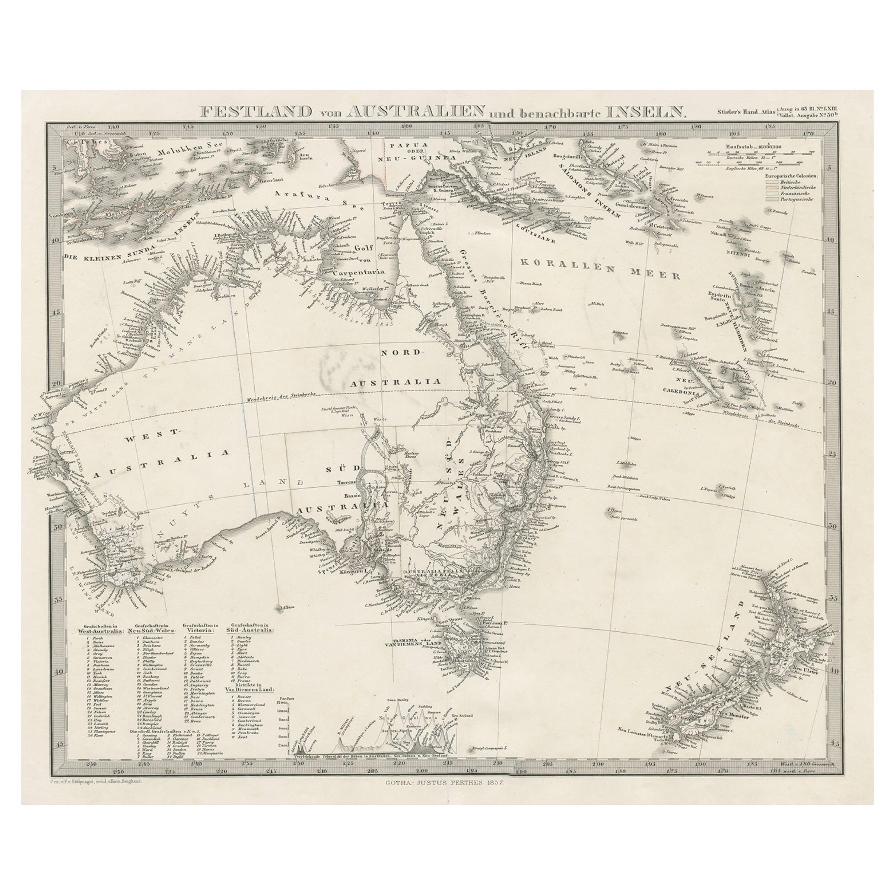
View AllGerman Antique Map of Australia and New Zealand, 1857
Located in Langweer, NL
Antique map Australia titled 'Festland von Australien und benachbarte Inseln'. Detailed map of Australia and New Zealand, including excellent det...
Category
Antique 19th Century Maps
Materials
Paper

$238 Sale Price
20% Off
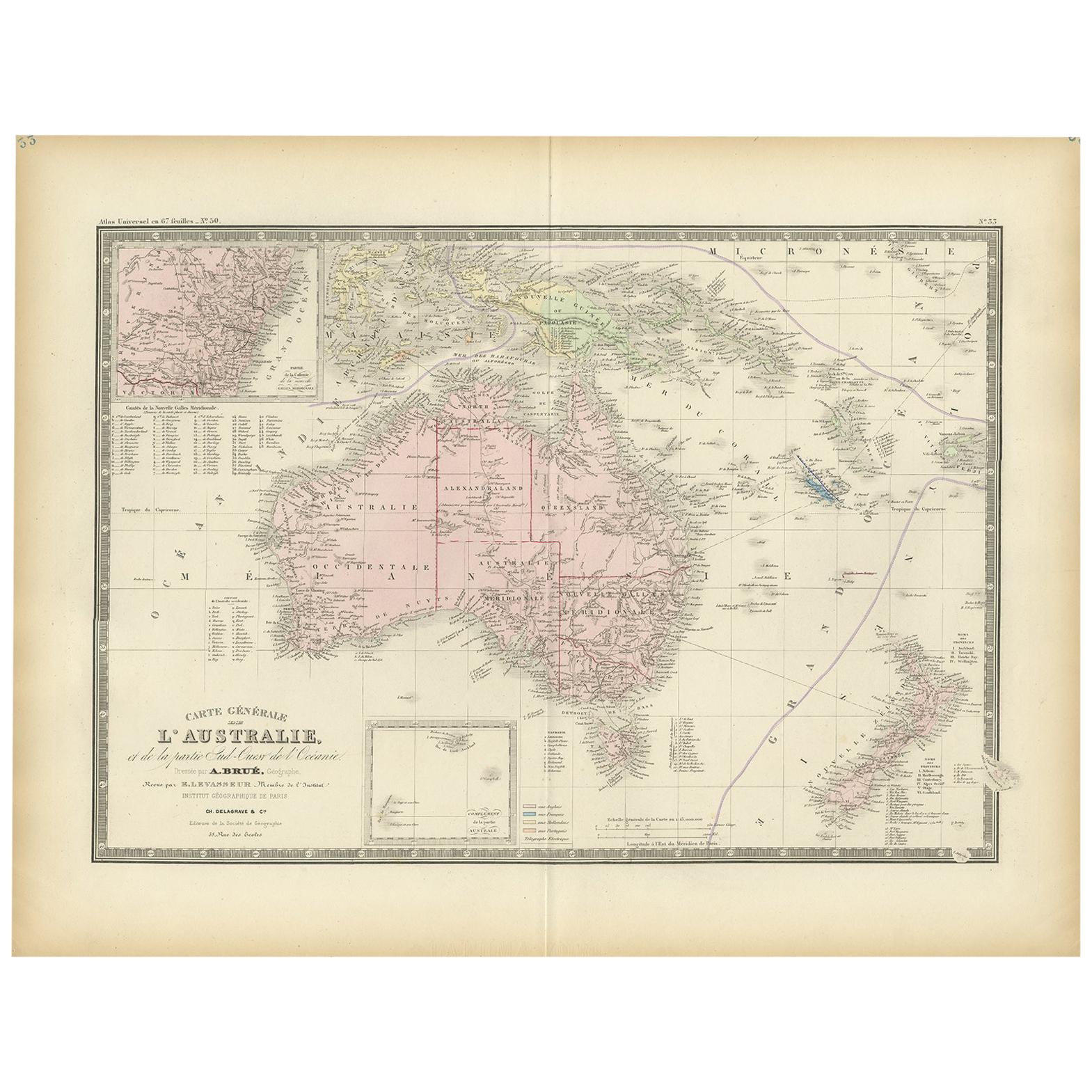
Antique Map of Australia by Levasseur, '1875'
Located in Langweer, NL
Antique map titled 'Carte générale de l'Australie'. Large map of Australia. This map originates from 'Atlas de Géographie Moderne Physique et Politiq...
Category
Antique Late 19th Century Maps
Materials
Paper

$416 Sale Price
30% Off
Antique Map of Australia and surrounding Islands by F. von Stülpnagel, 1850
Located in Langweer, NL
Antique map titled 'Festland von Asutralien und benachbarte Inseln'. Map showing Australia, New Zealand, Southern New-Guinea and surrounding islands. This map originates from Stieler...
Category
Antique Mid-19th Century Maps
Materials
Paper

$183 Sale Price
30% Off
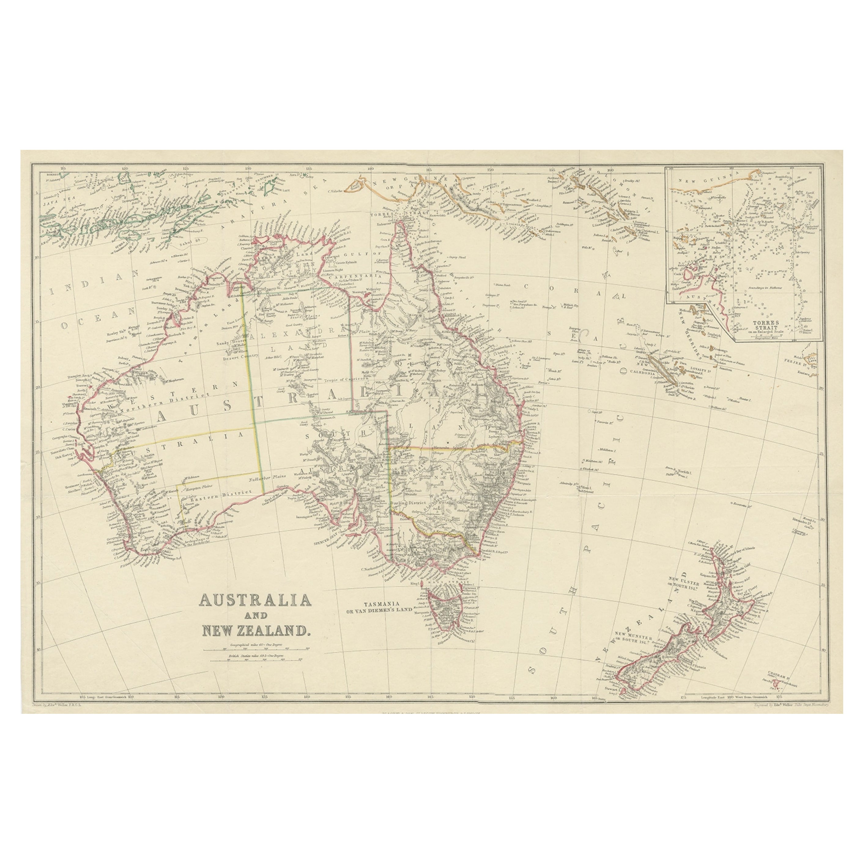
Antique Map of Australia and New Zealand, c.1860
Located in Langweer, NL
Antique map titled 'Australia and New Zealand'. Unusual edition of this map of Australia and New Zealand, on very thin paper and multiple folding lines. Source unknown, to be determi...
Category
Antique 19th Century Maps
Materials
Paper

$133 Sale Price
20% Off
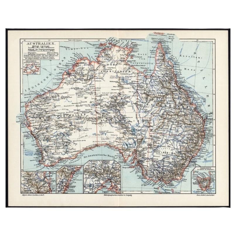
German Antique Map of Australia, Meyers, 1885
Located in Langweer, NL
Australien.' (Map of Australia. With inset maps of the large cities and Tasmania.) This attractive original old antique print / plate / map originate...
Category
Antique 19th Century Maps
Materials
Paper

$76 Sale Price
20% Off
Antique Map of Australia and New Zealand by W. G. Blackie, 1859
Located in Langweer, NL
Antique map titled 'Australia and New Zealand'. Original antique map of Australia and New Zealand with inset map of the Torres Strait. This map originates from ‘The Imperial Atlas of...
Category
Antique Mid-19th Century Maps
Materials
Paper

$238 Sale Price
20% Off
You May Also Like
Original Antique Map of Australia by Dower, circa 1835
Located in St Annes, Lancashire
Nice map of Australia
Drawn and engraved by J.Dower
Published by Orr & Smith. C.1835
Unframed.
Free shipping
Category
Antique 1830s English Maps
Materials
Paper

Large Original Antique Map of Australia by Sidney Hall, 1847
Located in St Annes, Lancashire
Great map of Australia
Drawn and engraved by Sidney Hall
Steel engraving
Original colour outline
Published by A & C Black. 1847
Unframed
Free shipping.
Category
Antique 1840s Scottish Maps
Materials
Paper

Australia, Tallis antique map, 1851
Located in Melbourne, Victoria
'Australia'
With decorative border surrounds and vignettes including a view of Sydney, Kangaroos, Natives of Australia Felix, Australian Parrots and Cockatoos and Natives of the Tri...
Category
19th Century Naturalistic Landscape Prints
Materials
Engraving

Original Antique Map of Tasmania, Australia by Dower, circa 1835
Located in St Annes, Lancashire
Nice map of Tasmania
Drawn and engraved by J.Dower
Published by Orr & Smith. C.1835
Unframed.
Free shipping
Category
Antique 1830s English Maps
Materials
Paper

Ancient Map of Oceania - Original Etching - 19th century
Located in Roma, IT
This Map of Oceania is an etching realized in the 19th century.
The state of preservation of the artwork is good. At the top of the paper, the inscription “Longitudine del Meridiano...
Category
19th Century More Prints
Materials
Etching

Original Antique Map of The World by Thomas Clerk, 1817
Located in St Annes, Lancashire
Great map of The Eastern and Western Hemispheres
On 2 sheets
Copper-plate engraving
Drawn and engraved by Thomas Clerk, Edinburgh.
Published by Mackenzie And Dent, 1817
...
Category
Antique 1810s English Maps
Materials
Paper

More Ways To Browse
In Australia
Historical Documents
Australian Antique Furniture
Antique Chart Table
Early American Chairs
Hans Muller
Vintage Wood Table With Glass Top
19th Century Square Table
Antonio Bonet
Galle Chairs
Large Chinese Rug
1940s Vintage French Art Deco
20th Century Spanish Table
Antonio Bellini
Retro Fiberglass Furniture
Shipping Crate
Antique Oushak Carpets
Blue Coffee Tables