Want more images or videos?
Request additional images or videos from the seller
1 of 10
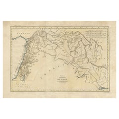
An Insightful 19th Century Map of Syria and the Surrounding Regions, 1882
Price:$220.59
$267.22List Price
About the Item
- Dimensions:Height: 14.97 in (38 cm)Width: 11.03 in (28 cm)Depth: 0 in (0.02 mm)
- Materials and Techniques:
- Place of Origin:
- Period:
- Date of Manufacture:1882
- Condition:Good condition. Study the image carefully.
- Seller Location:Langweer, NL
- Reference Number:Seller: BG-13601-2-431stDibs: LU3054337696022
About the Seller
5.0
Recognized Seller
These prestigious sellers are industry leaders and represent the highest echelon for item quality and design.
Platinum Seller
Premium sellers with a 4.7+ rating and 24-hour response times
Established in 2009
1stDibs seller since 2017
2,620 sales on 1stDibs
Authenticity Guarantee
In the unlikely event there’s an issue with an item’s authenticity, contact us within 1 year for a full refund. DetailsMoney-Back Guarantee
If your item is not as described, is damaged in transit, or does not arrive, contact us within 7 days for a full refund. Details24-Hour Cancellation
You have a 24-hour grace period in which to reconsider your purchase, with no questions asked.Vetted Professional Sellers
Our world-class sellers must adhere to strict standards for service and quality, maintaining the integrity of our listings.Price-Match Guarantee
If you find that a seller listed the same item for a lower price elsewhere, we’ll match it.Trusted Global Delivery
Our best-in-class carrier network provides specialized shipping options worldwide, including custom delivery.You May Also Like
Large 19th Century Map of France
Located in Pease pottage, West Sussex
Large 19th Century Map of France.
Remarkable condition, with a pleasing age worn patina.
Recently framed.
France Circa 1874.
Category
Antique Late 19th Century French Maps
Materials
Linen, Paper

Early 19th Century Hand Colored Map of the United States and Caribbean Islands
Located in Hamilton, Ontario
Hand coloured early 19th century map by Giraldon of France titled "Etats Unis et Grandes Antilles" (United States and Greater Antilles).
Category
Antique Early 19th Century French Maps
Materials
Paper

$595 Sale Price
40% Off
H 13.5 in W 10 in D 0.975 in
Framed Mid-19th Century Wall Map of Long Island, the Hamptons
Located in Sag Harbor, NY
A Framed museum quality find. This large wall map dates to the mid-1800s. Detailed inset maps of, Sag Harbor, East Hampton, Amagansett, Shelter Island and most villages in Long Island. It also has agriculture stats for 1855. Detailed prints of homes on Scuttle Hole in Bridgehampton as well as several other detailed prints. Lists of businesses, distance tables and railroad schedules and stops. The total amount of detailed information about Suffolk County Long Island is staggering. A unique rare New York map...
Category
Antique Mid-19th Century American Maps
Materials
Linen, Paper

$7,100 Sale Price
20% Off
H 51.5 in W 63 in D 1 in
Mid-19th Century Syrian Kabbalistic Copper Plate – Handcrafted and Engraved
Located in New York, NY
This intricately engraved copper plate from mid-19th century Syria is a remarkable example of Kabbalistic artistry and spiritual symbolism. Featuring finely inscribed Hebrew letters,...
Category
Antique Mid-19th Century Syrian Religious Items
Materials
Copper

$2,200
H 1.58 in Dm 9.06 in
19th Century Reprint of 16th Century Harbor Map of Copenhagen
Located in Haddonfield, NJ
This reprint of 1587 antique map of Copenhagen, Denmark retains its original mid-century mat and has been recently reframed in classic wood frame. The muted sepia colored map is a wo...
Category
Antique 1880s Danish Baroque Maps
Materials
Wood, Paper

19th Century Lithograph Map of Lower Manhattan, New York
Located in Haddonfield, NJ
1859 hand colored map of Lower Manhattan or New Amsterdam by George H. Moore.
Category
Antique 19th Century English Folk Art Maps
Materials
Paper

$620 Sale Price
20% Off
H 25.5 in W 31 in D 1 in
Late 19th Century Model of an Electric Powered Road Vehicle
Located in London, GB
A late 19th century brass model of an electric powered road locomotive.
4 inch rear wheels with gear drive from electric motor, front 4 inch wheels w...
Category
Antique Late 19th Century English Models and Miniatures
Materials
Brass
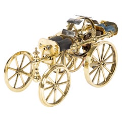
$3,973 Sale Price
20% Off
H 7 in W 13.25 in D 6.5 in
An English scale model of an early 19th century Hanson cab circa 1920
Located in Central England, GB
This fine and very well accomplished scratch built model is very pleasing to the eye with its exceptional detail, good scale and bright crisp paintwork.
It represents an early 19th-...
Category
Early 20th Century British Edwardian Models and Miniatures
Materials
Metal
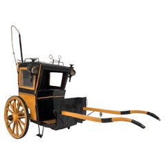
$1,752
H 11.82 in W 15.75 in D 7.49 in
An early 19th century gold and enamel vinaigrette, chain and ring
Located in Paris, FR
Antique gold and enamel vinaigrette suspended from two chains joined to a ring. The vinaigrette is decorated with multicolored bouquets of roses, an...
Category
Antique 1820s French Romantic Collectible Jewelry
Materials
Gold, Enamel

$21,473
H 4.34 in W 1.11 in D 1.11 in
Rare anatomical model: an external and inner ear, Italy end of 19th century.
Located in Milan, IT
Rare anatomical model for schools, educational use, depicting a separable external and internal ear, complete in all its parts, made of plaster and painted paper mache, metal hooks. ...
Category
Antique Late 19th Century Italian Scientific Instruments
Materials
Metal

$3,578
H 12 in W 19.75 in D 8 in
More From This Seller
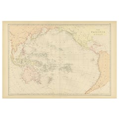
View All1882 Map of the Pacific Ocean Highlighting Islands and Surrounding Regions
Located in Langweer, NL
This 1882 map of the Pacific Ocean, published by Blackie and Son as part of the 'Comprehensive Atlas and Geography of the World,' presents a detailed and fascinating overview of the ...
Category
Antique 1880s Maps
Materials
Paper
Map of England and Surrounding Regions: Early 19th Century - 1802 Tardieu Atlas
Located in Langweer, NL
Title: Isles Britanniques. Troisieme Carte, Angleterre
Publication Details:
- **Atlas Title:** Nouvel Atlas Universel de Géographie Ancienne et Moderne
- **Purpose:** For the Nouve...
Category
Antique Early 1800s Maps
Materials
Paper
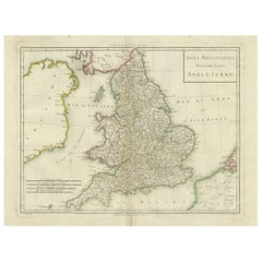
$362 Sale Price
20% Off
Antique 19th Century Map of Ancient Syria & Assyria - Historical Regions, c.1802
Located in Langweer, NL
19th Century Map of Ancient Syria and Assyria: 'Tabula Regiones inter Syriam et Assyriam continens'"*
This beautifully detailed 18th-century map, titled...
Category
Antique Early 1800s Maps
Materials
Paper
$296 Sale Price
20% Off
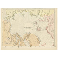
Arctic Exploration: An Original Map of the North Circumpolar Regions, 1882
Located in Langweer, NL
This map, extracted from the 1882 atlas by Blackie & Son, presents the North Circumpolar Regions in a projection centered on the North Pole, offering a unique view of the Arctic territories. The map's radial lines emanate from the pole, focusing on the northernmost parts of continents and the intricate archipelagos that are scattered across the Arctic Ocean.
The territories of Canada, Greenland, Northern Europe, Russia, and the northern extremities of Asia are portrayed with careful detail, highlighting the geography known to Victorian explorers. Notably, the map's color palette is subdued, with the cold regions depicted in pale hues, while coastlines and political boundaries are traced in warmer tones, providing a stark contrast that emphasizes the frigid environment.
The map likely served purposes both educational and navigational, capturing the extent of polar exploration at the time. Names of seas, straits, and islands honor explorers and patrons of the age of Arctic exploration, and the map also hints at the incomplete knowledge of the era, with some areas less detailed than others, reflecting the limits of exploration and cartographic knowledge of the Arctic region at that time.
Moreover, the map includes longitudinal and latitudinal markers, which would have been crucial for navigation and expedition planning. The inclusion of such detail illustrates the growing interest in polar exploration during the late 19th century...
Category
Antique 1880s Maps
Materials
Paper
$267 Sale Price
20% Off
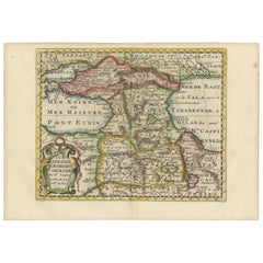
Historical Map of the Black Sea and Surrounding Regions, 1705
Located in Langweer, NL
Title: "Map of Turcomania, Georgia, and Comania"
This print presents an intricately detailed map of the Caucasus region, titled “Turcomania, Georgien Commanie,” by the esteemed cart...
Category
Antique Early 1700s Maps
Materials
Paper
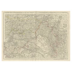
Antique Map of Champagne and surrounding Regions, France
Located in Langweer, NL
Antique map titled 'Carte de la Champagne et des Pays Voisins (..)'. Detailed map of Champagne and surrounding regions of Chalons and Soissons, Reims,...
Category
Antique Mid-18th Century Maps
Materials
Paper
Recently Viewed
View AllMore Ways To Browse
Stretcher Tables
M Table
Antique Sultanabad Carpets
China Chair
English Antique Desks
Used Beige Sofa
Antique Plate Germany
Hand Tufted Rugs
Rare China
Side Table Made In Denmark
Thonet Antique
Victorian Hall Tables
Vintage Computer
England Antique Plates
19th Century Round Dining Table
Antique Counters
Antique Thrones
Carved Chinese Tables