Items Similar to Lleida 1902: A Cartographic Perspective of Catalonia's Gateway to the Pyrenees


Want more images or videos?
Request additional images or videos from the seller
1 of 7
Lleida 1902: A Cartographic Perspective of Catalonia's Gateway to the Pyrenees
$287.70
$359.6320% Off
£213.72
£267.1520% Off
€240
€30020% Off
CA$399.50
CA$499.3820% Off
A$435.95
A$544.9420% Off
CHF 228.66
CHF 285.8320% Off
MX$5,294.79
MX$6,618.4820% Off
NOK 2,856.14
NOK 3,570.1820% Off
SEK 2,699.20
SEK 3,37420% Off
DKK 1,827.09
DKK 2,283.8720% Off
About the Item
The map for sale shows the province of Lleida, located in the western part of Catalonia, Spain, as of 1902. Here are the key features depicted on the map:
- **Topography**: The map indicates the varied landscape of Lleida, including the Pyrenees mountains in the north, which are significant for their height and natural parks.
- **Hydrography**: Blue lines represent the rivers, which likely include the Segre, a major tributary of the Ebro river that flows through the province.
- **Transportation**: Red lines illustrate the roads and railways, outlining the infrastructure that connects Lleida's towns and cities both within the province and to other areas.
- **Urban Centers**: Various symbols mark the locations of cities, towns, and villages, with the capital city, also named Lleida (Lérida in Spanish), presumably indicated.
- **Political Boundaries**: Dotted lines may represent the administrative boundaries within the province.
- **Legend**: The map includes a legend (Signos Convencionales) explaining the symbols used for provincial capitals, roads, railways, and other landmarks.
- **Scale**: There is a scale in kilometers at the bottom, allowing for distance measurements.
- **Coat of Arms**: The coat of arms of Lleida is prominently featured, incorporating symbols of the province's identity and heritage.
About the province of Lleida:
Lleida is known for its rich historical and cultural heritage, which includes Romanesque churches and monasteries in the Vall de Boí, a UNESCO World Heritage Site. The province's economy is diverse, encompassing agriculture, with a focus on fruit production, as well as tourism, especially for winter sports in the Pyrenees. Lleida also hosts the University of Lleida, one of the oldest in Catalonia. The province's gastronomy includes dishes like escudella, a type of stew, and products like pears and apples from its extensive orchards. Cultural events such as the Aplec del Caragol, a large snail-eating festival, and the Festa Major de Sant Joan, a celebration of the summer solstice, are integral to the region's identity.
- Dimensions:Height: 20.08 in (51 cm)Width: 14.77 in (37.5 cm)Depth: 0 in (0.02 mm)
- Materials and Techniques:
- Period:1900-1909
- Date of Manufacture:1902
- Condition:Good condition. Central vertical folding lines as issued. Aged paper with typically warm, yellowish-brown hue, especially around the edges. Check the images carefully.
- Seller Location:Langweer, NL
- Reference Number:Seller: BG-13642-241stDibs: LU3054338032082
About the Seller
5.0
Recognized Seller
These prestigious sellers are industry leaders and represent the highest echelon for item quality and design.
Platinum Seller
Premium sellers with a 4.7+ rating and 24-hour response times
Established in 2009
1stDibs seller since 2017
2,647 sales on 1stDibs
Typical response time: <1 hour
- ShippingRetrieving quote...Shipping from: Langweer, Netherlands
- Return Policy
Authenticity Guarantee
In the unlikely event there’s an issue with an item’s authenticity, contact us within 1 year for a full refund. DetailsMoney-Back Guarantee
If your item is not as described, is damaged in transit, or does not arrive, contact us within 7 days for a full refund. Details24-Hour Cancellation
You have a 24-hour grace period in which to reconsider your purchase, with no questions asked.Vetted Professional Sellers
Our world-class sellers must adhere to strict standards for service and quality, maintaining the integrity of our listings.Price-Match Guarantee
If you find that a seller listed the same item for a lower price elsewhere, we’ll match it.Trusted Global Delivery
Our best-in-class carrier network provides specialized shipping options worldwide, including custom delivery.More From This Seller
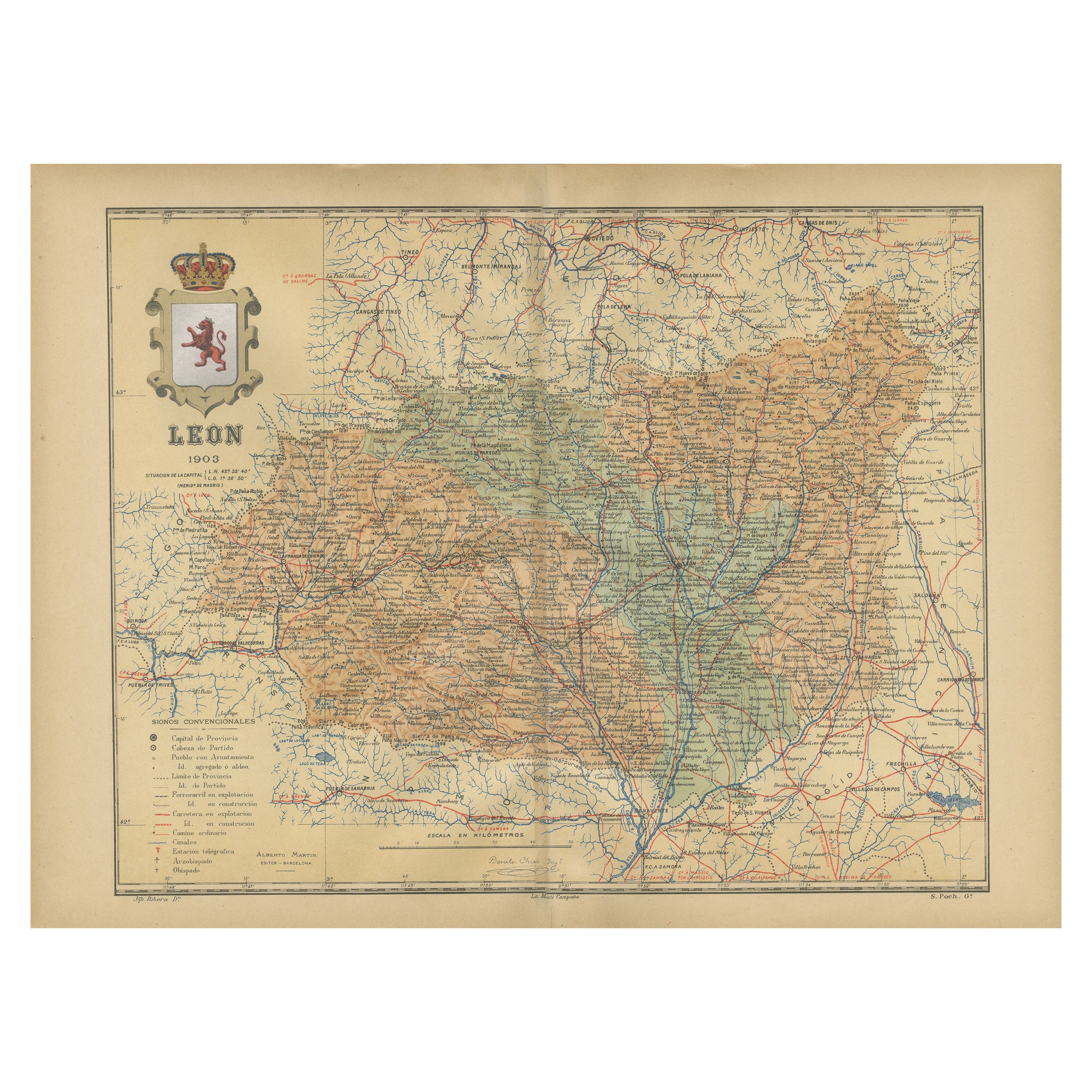
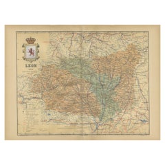
View AllLeón 1903: A Cartographic Detailing of Castilla y León's Mountainous Province
Located in Langweer, NL
The map depicts the province of León, which is located in the northwest of Spain and forms part of the autonomous community of Castilla y León, as of 1903. Notable features of the ma...
Category
Antique Early 1900s Maps
Materials
Paper
$278 Sale Price
20% Off
Free Shipping
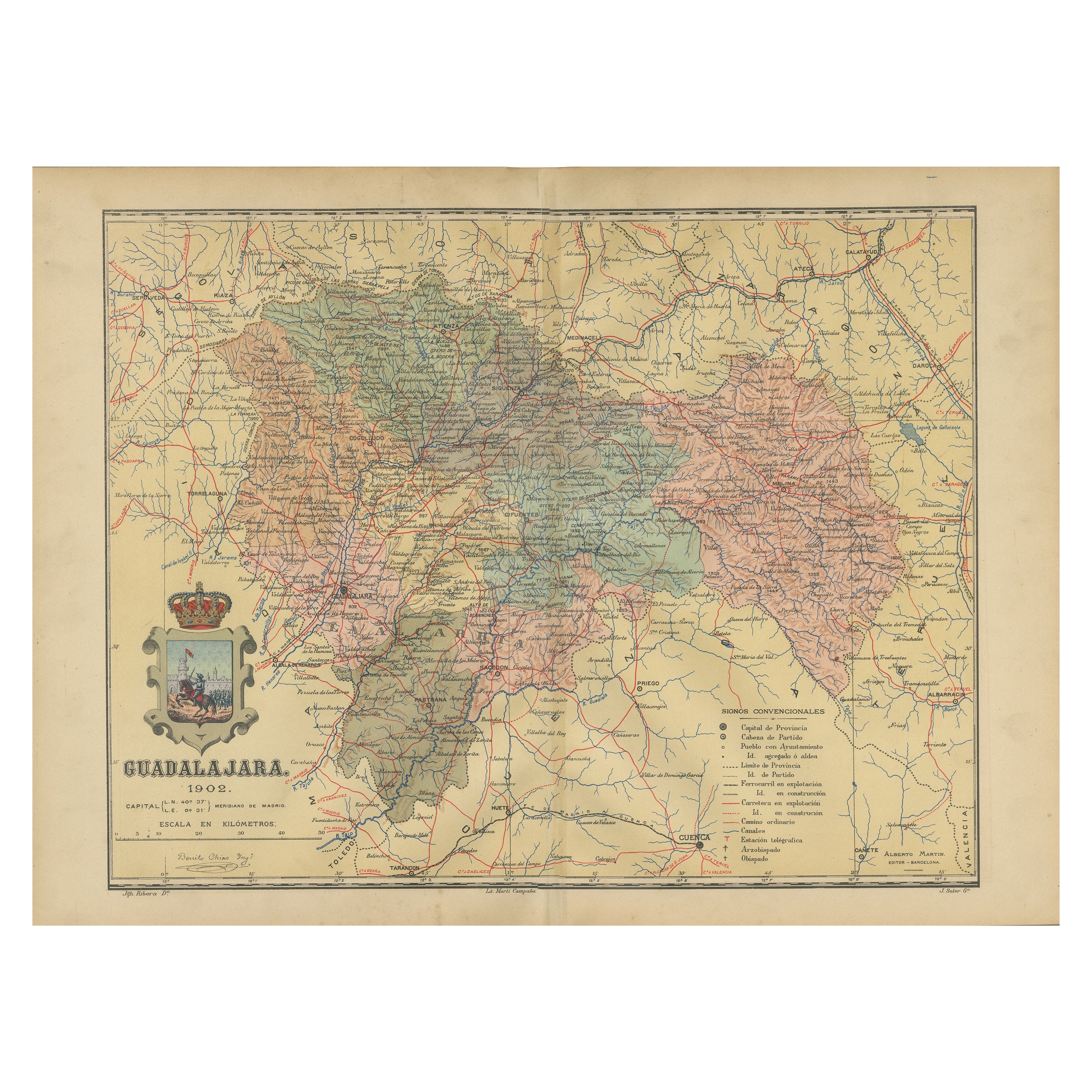
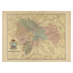
Guadalajara 1902: A Cartographic Image of Castilla-La Mancha's Northern Province
Located in Langweer, NL
The map illustrates the province of Guadalajara, part of the autonomous community of Castilla-La Mancha in Spain, as of 1902. The map includes various geographic and infrastructural ...
Category
Antique Early 1900s Maps
Materials
Paper
$278 Sale Price
20% Off
Free Shipping
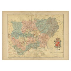
Jaén 1902: A Cartographic Depiction of Andalusia's Olive Heartland
Located in Langweer, NL
This original antique map displays the province of Jaén, located in the autonomous community of Andalusia in southern Spain, as of the year 1902. It contains various geographic and i...
Category
Antique Early 1900s Maps
Materials
Paper
$278 Sale Price
20% Off
Free Shipping
Navarra in Cartographic Detail: A 1902 Map of the Crossroads of Northern Spain
Located in Langweer, NL
The original antique map for sale shows the Spanish province of Navarra as it was in 1902. Here's a brief description and a potential title for the map:
Description:
- The map detai...
Category
Antique Early 1900s Maps
Materials
Paper

$326 Sale Price
20% Off
Free Shipping
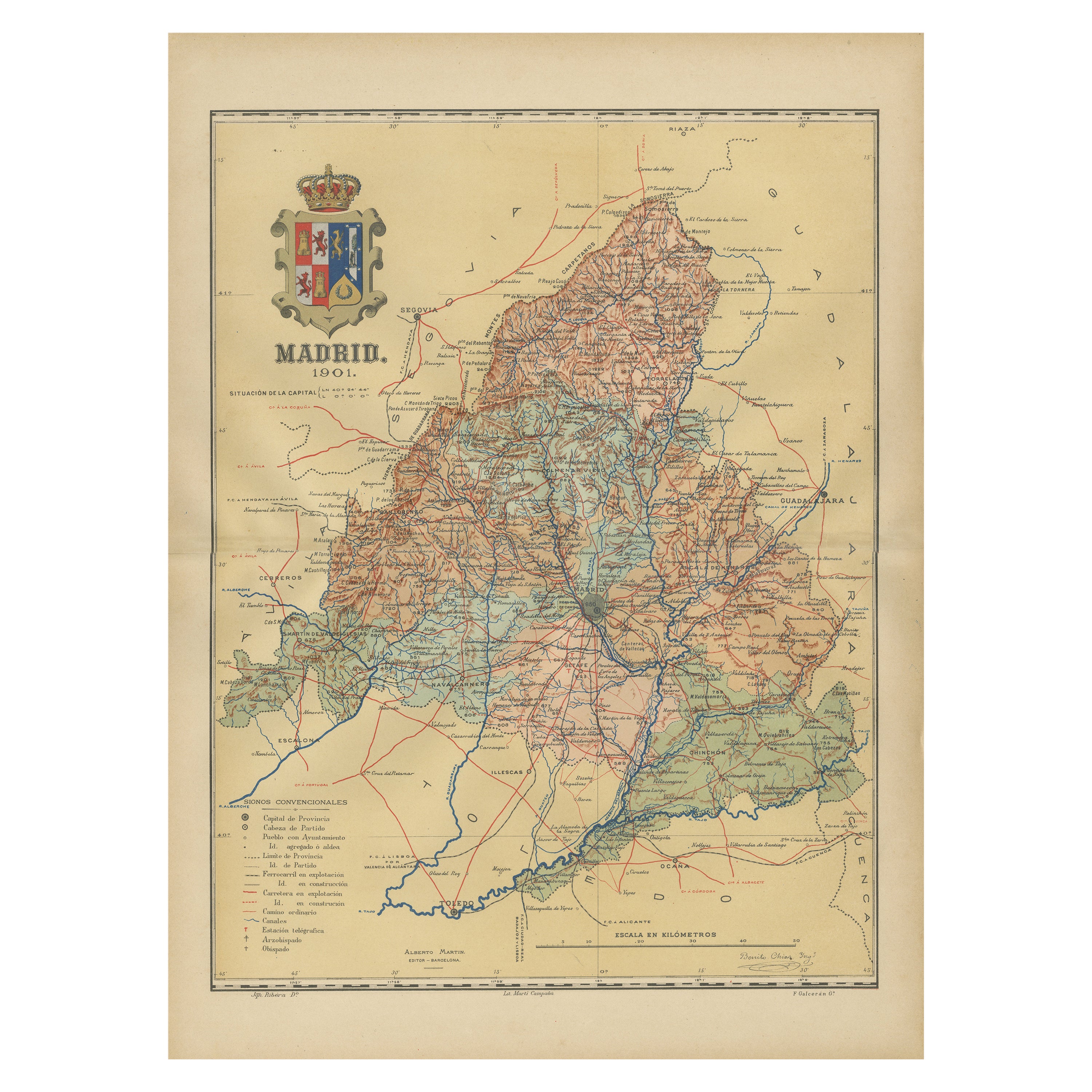
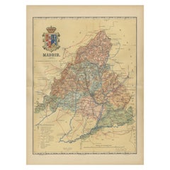
Madrid 1901: A Historical Map of Spain's Capital Province
Located in Langweer, NL
The map is of the province of Madrid, the capital region of Spain, as it appeared in 1901. Here are the key features it displays:
The map shows the central part of Spain, with the Guadarrama mountain range prominently visible, marking the natural border to the north of Madrid.
Blue lines likely indicate rivers, including the Manzanares River, which flows through Madrid, and the Jarama River, a tributary to the Tagus.
Red lines depict the roads and railways, outlining the infrastructure that connects Madrid's various towns and cities within the province and beyond.
Symbols and labels mark the locations of cities, towns, and villages, with Madrid itself likely being the focal point. Dotted lines may represent the administrative divisions within the province. The map includes a legend (Signos Convencionales) that explains the symbols used for provincial capitals, roads, railways, and other geographic features.
The coat of arms of Madrid, featuring a bear and a strawberry tree (madroño), is prominently featured, symbolizing the city's and the province's historical coat of arms.
About the province of Madrid:
Madrid is not only the capital of Spain but also the heart of the Iberian Peninsula, both geographically and politically. The city is renowned for its rich repositories of European art, including the Prado Museum's works by Goya, Velázquez, and other Spanish masters. The province of Madrid is characterized by a blend of historical and modern elements, with a rich cultural life that includes theater, opera, and flamenco, as well as gastronomy that features a mix of traditional Spanish dishes and international cuisine...
Category
Antique Early 1900s Maps
Materials
Paper
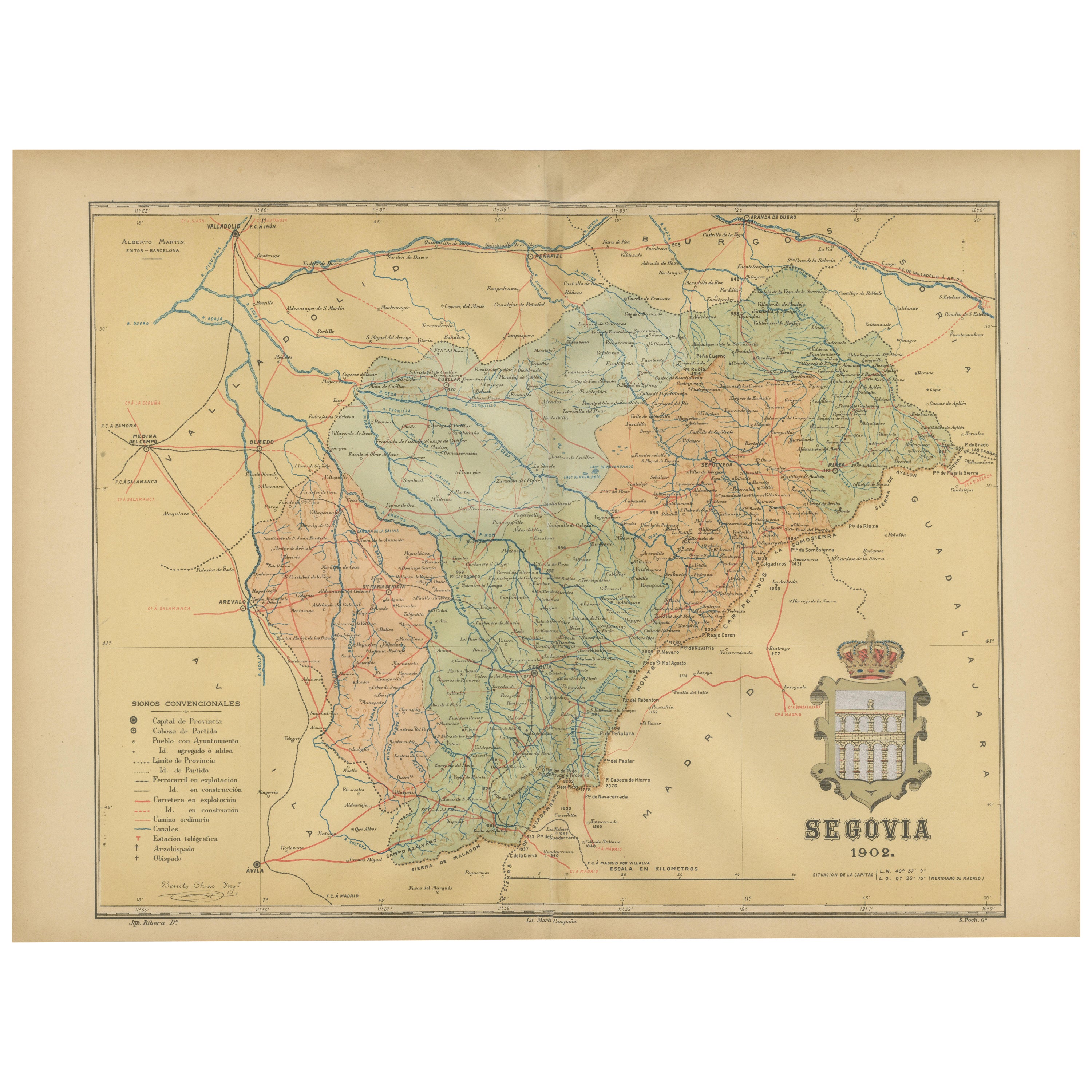
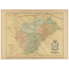
Topographical and Administrative Cartography of Segovia in Spain, 1902
Located in Langweer, NL
An original old map of the province of Segovia from the year 1902. Segovia is a historic area located in the central part of Spain, northwest of Madrid. Known for its rich history, a...
Category
Antique Early 1900s Maps
Materials
Paper
$278 Sale Price
20% Off
Free Shipping
You May Also Like
Large Original Vintage Map of Spain, circa 1920
Located in St Annes, Lancashire
Great map of Spain
Original color.
Good condition
Published by Alexander Gross
Unframed.
Category
Vintage 1920s English Maps
Materials
Paper

Austria-Hungary, Western Part. Century Atlas antique vintage map
Located in Melbourne, Victoria
'The Century Atlas. Austria-Hungary, Western Part'
Original antique map, 1903.
Central fold as issued. Map name and number printed on the reverse corners.
Sheet 40cm by 29.5cm.
Category
Early 20th Century Victorian More Prints
Materials
Lithograph

Ancient National Atlas of France with Marengo
Located in Alessandria, Piemonte
Ancient National Atlas of France with the department of Marengo: a rare French etching dated 1806.
ST/178.
Category
Antique Early 19th Century French Other Prints
Materials
Paper

Original Antique Map of Spain and Portugal, circa 1790
Located in St Annes, Lancashire
Super map of Spain and Portugal
Copper plate engraving by A. Bell
Published, circa 1790.
Unframed.
Category
Antique 1790s English Other Maps
Materials
Paper

Geographical Antique Map of Principality of Monaco
By Bruno Santini
Located in Alessandria, Piemonte
ST/609 - Interesting antique color map of Monaco Principality in French language : "Carte qui contient le Principauté de Piémont, le Monferrat et la comté de...
Category
Antique Late 18th Century Italian Other Maps
Materials
Paper

Map Bedfordshire No 3 General Framed
Located in BUNGAY, SUFFOLK
A general map of Bedfordshire with its hundreds. Measure: 37cm 14 1/2" high
A scale of 5 miles.
in the original green mount and traditional black and gold frame.
charming map with...
Category
Antique 18th Century English Georgian Maps
Materials
Paper

More Ways To Browse
Antique Sultanabad Carpets
Used Beige Sofa
Antique Plate Germany
Hand Tufted Rugs
Rare China
Side Table Made In Denmark
Thonet Antique
Victorian Hall Tables
Vintage Computer
England Antique Plates
19th Century Round Dining Table
Antique Counters
Antique Thrones
Carved Chinese Tables
Italian Ceramic 1960s
Mid Century Modern Danish Teak Dining Tables
Rosenthal Century
Long Rug Runners