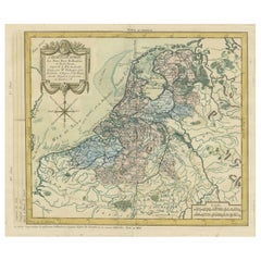
Items Similar to Matthaus Seutter, Framed 1730 Color Engraving Map of "Belgium Fonderatum"


Want more images or videos?
Request additional images or videos from the seller
1 of 14
Matthaus Seutter, Framed 1730 Color Engraving Map of "Belgium Fonderatum"
$1,400
£1,061.39
€1,223.50
CA$1,971.68
A$2,186.44
CHF 1,148.81
MX$26,714.61
NOK 14,373.22
SEK 13,491.72
DKK 9,133.70
About the Item
Label on verso. From Grosser Atlas. The name Belgium comes from the ancient designation "Gallis Belgica". Figural decoration upper left. M. Seutter was a famed German mapmaker in the 18th c. There is a presentation inscription on the back as well as some signatures.
Dimensions: sight 19 1/4 x 22 1/4"
matted and framed in burled wood 27 1/2”x 31" x .75” deep.
Condition: Please see all detail photos. There are some age-related brown spots in the sea upper center, otherwise good condition and presenting very well.
- Dimensions:Height: 27.5 in (69.85 cm)Width: 31 in (78.74 cm)Depth: 0.75 in (1.91 cm)
- Style:Renaissance (In the Style Of)
- Materials and Techniques:
- Place of Origin:
- Period:
- Date of Manufacture:18th Century
- Condition:Wear consistent with age and use.
- Seller Location:Bridgeport, CT
- Reference Number:Seller: 1218071stDibs: LU1755232934792
About the Seller
5.0
Vetted Professional Seller
Every seller passes strict standards for authenticity and reliability
1stDibs seller since 2015
2,063 sales on 1stDibs
Typical response time: <1 hour
- ShippingRetrieving quote...Shipping from: Bridgeport, CT
- Return Policy
Authenticity Guarantee
In the unlikely event there’s an issue with an item’s authenticity, contact us within 1 year for a full refund. DetailsMoney-Back Guarantee
If your item is not as described, is damaged in transit, or does not arrive, contact us within 7 days for a full refund. Details24-Hour Cancellation
You have a 24-hour grace period in which to reconsider your purchase, with no questions asked.Vetted Professional Sellers
Our world-class sellers must adhere to strict standards for service and quality, maintaining the integrity of our listings.Price-Match Guarantee
If you find that a seller listed the same item for a lower price elsewhere, we’ll match it.Trusted Global Delivery
Our best-in-class carrier network provides specialized shipping options worldwide, including custom delivery.More From This Seller
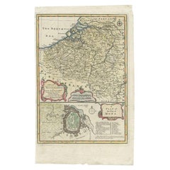
View AllFramed 1731 Color Engraving, Map of Rotterdam by Matthaus Seutter, "Roterodami"
Located in Bridgeport, CT
"Roterodami". Seutter (1678-1757) was an important German 18th century map maker. Bird's eye view of the city above with full details, neoclassi...
Category
Antique 18th Century European Renaissance Maps
Materials
Glass, Wood, Paper

Johann Georg Rosenberg (1739-1808) Hand Colored Engravings, Berlin & Amsterdam
Located in Bridgeport, CT
"Grand Place du Chateau et de la Rue Royale prise du Coee des Arcades". A view of the Berlin city square with the old neoclassical palace decorated with sculptures along the roof and...
Category
Antique 18th Century European Renaissance Prints
Materials
Gesso, Glass, Giltwood, Paper

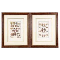
Niccolo Gualtieri, Florentine Conchologist/Artist, Two Framed 1742 Engravings
By Niccolo Gualtier
Located in Bridgeport, CT
Niccolo Gualtieri, Florentine Conchologist/ Artist- Two Framed 1742 Italian Hand Colored Copper Bookplate Engravings- Seashells, From Gualtieri's book "Index Testarum Conchyliorum......
Category
Antique 18th Century Italian Renaissance Prints
Materials
Glass, Wood, Paper
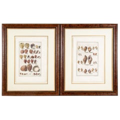
Niccolo Gualtieri, Florentine Conchologist/Artist, Two Framed 1742 Engravings
By Niccolo Gualtier
Located in Bridgeport, CT
Niccolo Gualtieri, Florentine Conchologist/ Artist- Two Framed 1742 Italian Hand Colored Copper Bookplate Engravings- Seashells, From Gualtieri's book "Index Testarum Conchyliorum...Museo Nicolai...
Category
Antique 18th Century Italian Rococo Prints
Materials
Wood, Paper
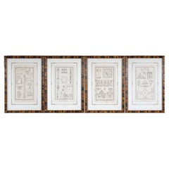
Set Of Four Antique Neoclassical Engravings by Pierre Nicolas Beauvallet
Located in Bridgeport, CT
Set of four neoclassical engravings by Pierre Nicolas Beauvallet (French, 1750–1818. Presented in paint decorated custom frames.
The engravings with depictions of neoclassical figure...
Category
Antique Early 19th Century French Neoclassical Prints
Materials
Glass, Wood, Paper
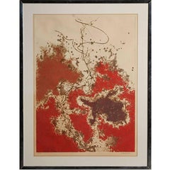
Mid Century 1973 Signed Colored Engraving
Located in Bridgeport, CT
Abstract in browns and red on ecru. Pencil signed indistinctly (possibly Y. Bishop) and dated 73 lower right, numbered 64/70 lower left. Embossed French gallery mark lower right. Fra...
Category
Vintage 1970s Mid-Century Modern Prints
Materials
Wood, Paper
You May Also Like
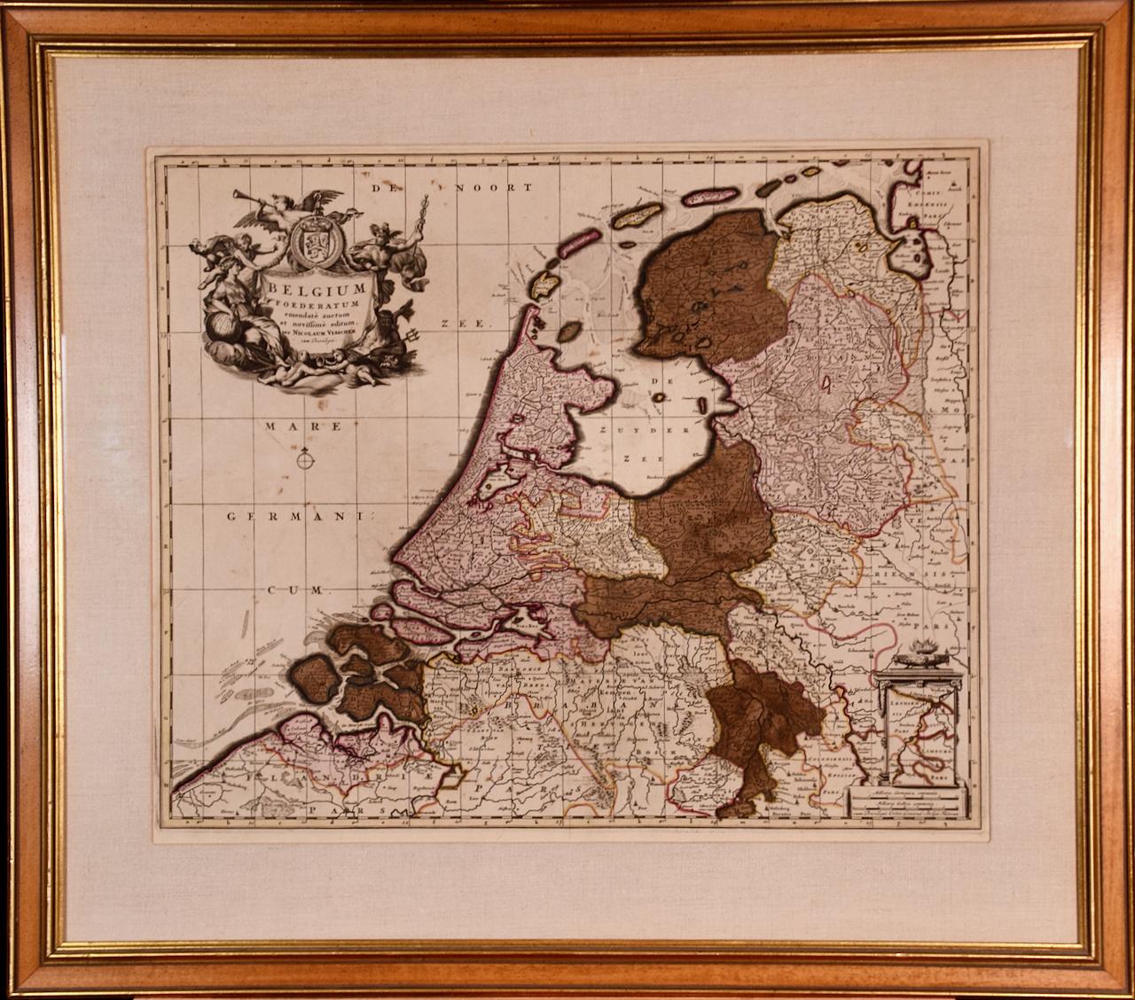
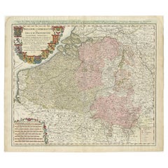
Belgium and the Netherlands: A Hand-colored 17th Century Map by Visscher
By Nicolaus Visscher
Located in Alamo, CA
This is an original hand-colored 17th century map of Belgium by Nicolaus (Nicolas) Visscher II entitled "Belgium Foederatum emendate auctum et novissime editum", published in Amsterdam in 1678. The map shows the seven provinces comprising the Belgium federation or the Republic of the Seven United Netherlands or the Dutch Republic as it was also known. The republic was formed when an alliance of seven Dutch provinces in the Spanish Netherlands revolted against rule by Spain in 1579 (the Union of Utrecht) and declared their independence in 1581 (the Act of Abjuration). The seven provinces were Groningen, Frisia, Overijssel, Guelders, Utrecht, Holland and Zeeland. This was a predecessor state to the Netherlands and the first fully independent Dutch nation state. Amsterdam, Delft, Rouen, Utrecht, Brugge, Ghent, and Antwerp are all included on the map. A small inset map in the lower right depicts the course of the Maas River from Maastricht to Wessem. There is a decorative cartouche in the upper left corner and a distance scale cartouche in the lower right corner.
The map is presented in an attractive antiqued medium brown-colored wood frame with gold-colored inner and outer trim and a light tan-colored fabric mat. The frame measures 26.63" high by 30" wide by 0.75" deep. There is some darkening of the red areas in the map, presumably related to oxidation of the original iron containing pigment over time. There are also a few scattered spots. The map is otherwise in very good condition.
The Visscher family were one of the great cartographic families of the 17th century. Begun by Claes Jansz Visscher...
Category
Late 17th Century Other Art Style Landscape Prints
Materials
Engraving

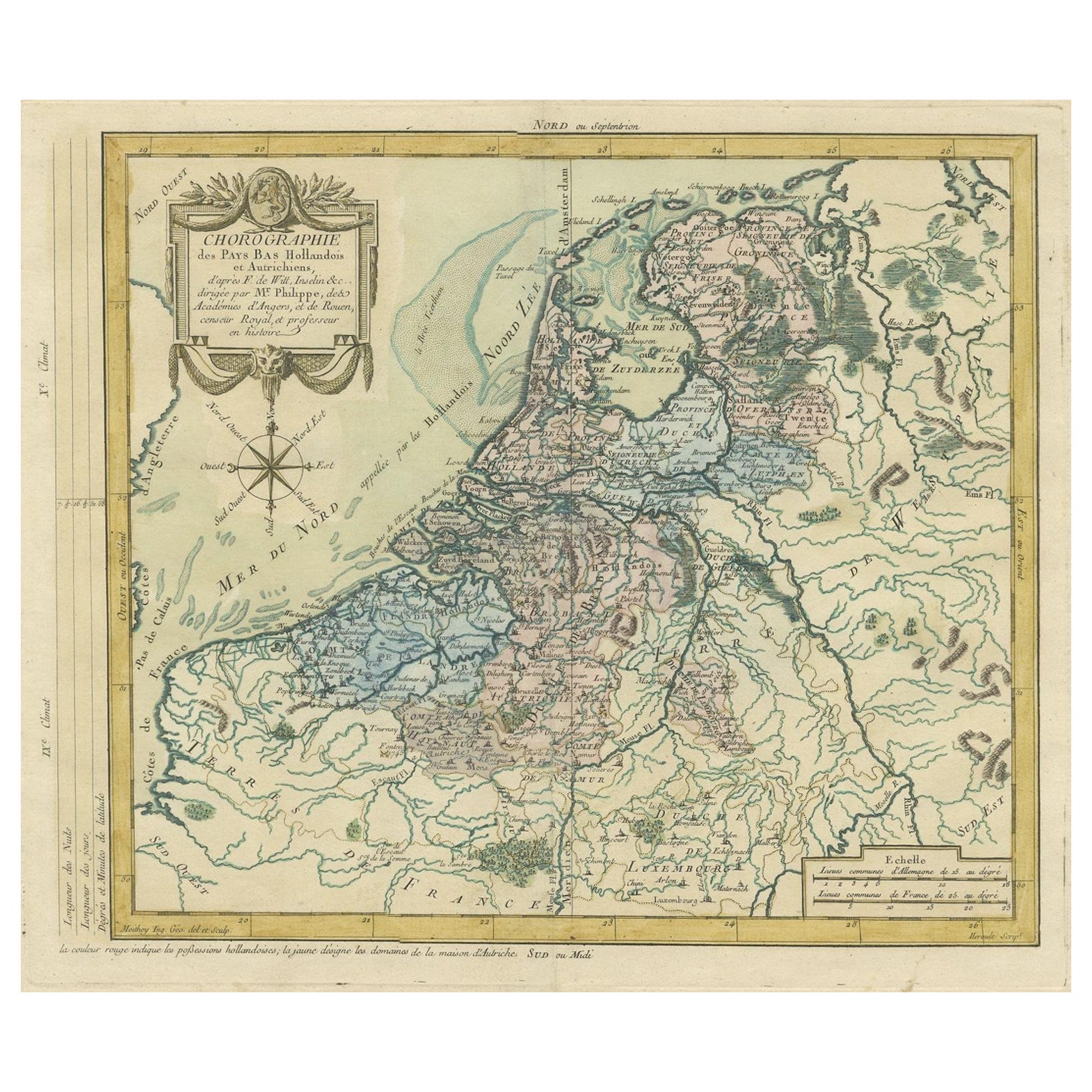
Copper Engraving of The Dutch and Austrian Netherlands Handcolored, 1772
Located in Langweer, NL
This antique map, a rare hand-colored engraved piece by E.A. Philippe de Pretot, showcases intricate detailing and vibrant colors. The dimensions of the map measure approximately 33 ...
Category
Antique 1640s Prints
Materials
Paper
$247 Sale Price
20% Off
Antique Map of the Netherlands and Belgium by Homann, circa 1710
By Johann Baptist Homann
Located in Langweer, NL
Antique map titled 'Tabula Generalis Totius Belgii Provinciae XVII. Infer. Germaniae (..)'. Map of the Benelux countries by Johann Baptist Homann. Shows the area between the Seine es...
Category
Antique Early 18th Century German Maps
Materials
Paper

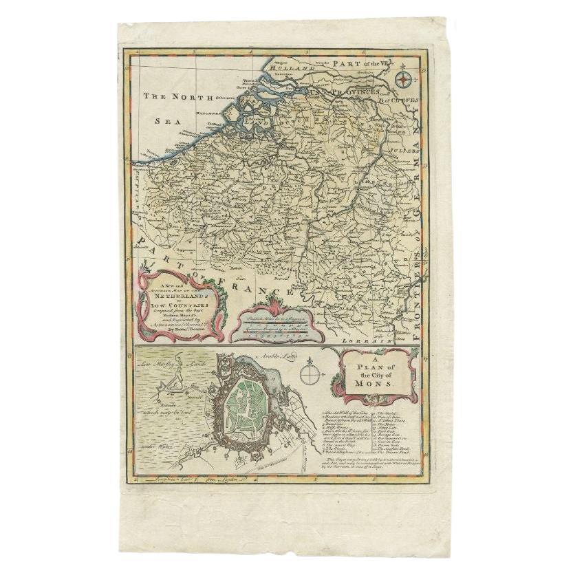
Antique Map of the Netherlands and Belgium by Bowen, 1747
By Emanuel Bowen
Located in Langweer, NL
Antique map Belgium titled 'A New and Accurate Map of the Netherlands or Low Countries'. Detailed map of South of the Netherlands and Belgium. With large inset of the city of Mons, B...
Category
Antique 18th Century Maps
Materials
Paper
$206 Sale Price
20% Off
Antique Map of Belgium and Luxembourg by Homann Heirs, 1747
Located in Langweer, NL
Antique map titled 'Belgium Catholicum seu Decem provinciae Germaniae Inferioris cum confiniis Germaniae sup. et Francia (..).' Detailed map of Belgium ...
Category
Antique 18th Century Maps
Materials
Paper
$452 Sale Price
20% Off
Antique Map of Flanders 'Belgium' by F. de Wit, circa 1680
Located in Langweer, NL
Antique map titled 'Comitatus Flandriae Tabula, in Lucem Edita'. Large map of Flanders, Belgium. Published by F. de Wit, circa 1680.
Category
Antique Late 17th Century Maps
Materials
Paper

$571 Sale Price
20% Off
More Ways To Browse
German Renaissance Wood Furniture
Laos Antique Map
Orinoco Furniture
Johann Baptist Homann On Sale
Rand Mcnally Vintage Maps
Tipu Sultan
Antique Map Bermuda
Antique Map Holder
Lancashire Map
Maltese Falcon
Raised Relief Map
William Dampier
Antique Chesapeake Bay Map
Astrology Map
Mauritius Antique Map
Oman Map
Tanzania Antique Map
Georgetown Map