Items Similar to Nautical Chart of Cape Verde Islands by J.W. Norie, 1824 Coastal Map


Want more images or videos?
Request additional images or videos from the seller
1 of 10
Nautical Chart of Cape Verde Islands by J.W. Norie, 1824 Coastal Map
$2,271.67
£1,681.72
€1,900
CA$3,143.42
A$3,465.55
CHF 1,813.06
MX$42,515.89
NOK 22,822.90
SEK 21,343.02
DKK 14,473.03
About the Item
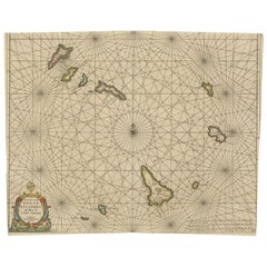
Nautical Chart of Cape Verde Islands by J.W. Norie, 1824 Coastal Map
This beautifully engraved nautical chart, titled “A New Chart of the Cape Verde Islands,” was drawn by J.W. Norie and published in 1824 by J.W. Norie and Co., renowned hydrographers based in London. The map presents the Cape Verde archipelago off the west coast of Africa in exquisite detail, compiled from the latest navigational data available at the time. Norie, one of the foremost British cartographers and nautical publishers of the early 19th century, was known for his precise and practical charts used by mariners during the height of British naval power and global trade expansion.
The central focus of the map is the group of islands including St. Antonio, St. Vincent, Brava, Fogo, St. Nicholas, St. Jago, Sal, and Bonavista. Each island is carefully outlined and hand-colored, showing coastal features, safe anchorages, and key towns or ports. Radiating compass lines connect the islands, offering navigational bearings that would have been crucial for 19th-century seafarers.
In addition to the main chart, three inset maps provide detailed views of Port Praya (Isle of St. Jago), Porto Grande (Island of St. Vincent), and English Road (Island of Mayo), with soundings and anchoring details noted. The chart also features coastal profile views—silhouettes of the islands as seen from sea—helping mariners recognize landfalls visually.
Printed on fine paper and delicately hand-colored, this chart exemplifies the intersection of utility and artistry in maritime cartography. Norie’s charts were not only tools of navigation but also reflections of geopolitical importance and expanding trade networks during the early 1800s.
Condition Report:
Good condition for its age. Minor age toning. On the edges some short tears and creases, mostly only touching the plate-mark. Right border has been re-inforced and repaired professionally. Paper remains strong, and hand coloring is vivid and original.
Tips for Framing:
Use a classic black or gold-leaf frame with a light cream or ivory mat to highlight the marine details and fine linework. A larger mat border gives space to appreciate the map’s insets and decorative features. Use UV-protective glass to preserve color.
- Dimensions:Height: 28.35 in (72 cm)Width: 17.52 in (44.5 cm)Depth: 0.01 in (0.2 mm)
- Materials and Techniques:Paper,Engraved
- Place of Origin:
- Period:
- Date of Manufacture:1824
- Condition:Replacements made: Right border has been professionally replaced top to bottom on the platemark line. Good condition for its age. Minor age toning. On the edges some small tears and creases, mostly only touching the plate-mark. Right border has been re-inforced and repaired professionally. Paper remains strong and hand coloring is vivid and original.
- Seller Location:Langweer, NL
- Reference Number:Seller: BG-13730-11stDibs: LU3054345323222
About the Seller
5.0
Recognized Seller
These prestigious sellers are industry leaders and represent the highest echelon for item quality and design.
Platinum Seller
Premium sellers with a 4.7+ rating and 24-hour response times
Established in 2009
1stDibs seller since 2017
2,609 sales on 1stDibs
Typical response time: <1 hour
- ShippingRetrieving quote...Shipping from: Langweer, Netherlands
- Return Policy
Authenticity Guarantee
In the unlikely event there’s an issue with an item’s authenticity, contact us within 1 year for a full refund. DetailsMoney-Back Guarantee
If your item is not as described, is damaged in transit, or does not arrive, contact us within 7 days for a full refund. Details24-Hour Cancellation
You have a 24-hour grace period in which to reconsider your purchase, with no questions asked.Vetted Professional Sellers
Our world-class sellers must adhere to strict standards for service and quality, maintaining the integrity of our listings.Price-Match Guarantee
If you find that a seller listed the same item for a lower price elsewhere, we’ll match it.Trusted Global Delivery
Our best-in-class carrier network provides specialized shipping options worldwide, including custom delivery.More From This Seller
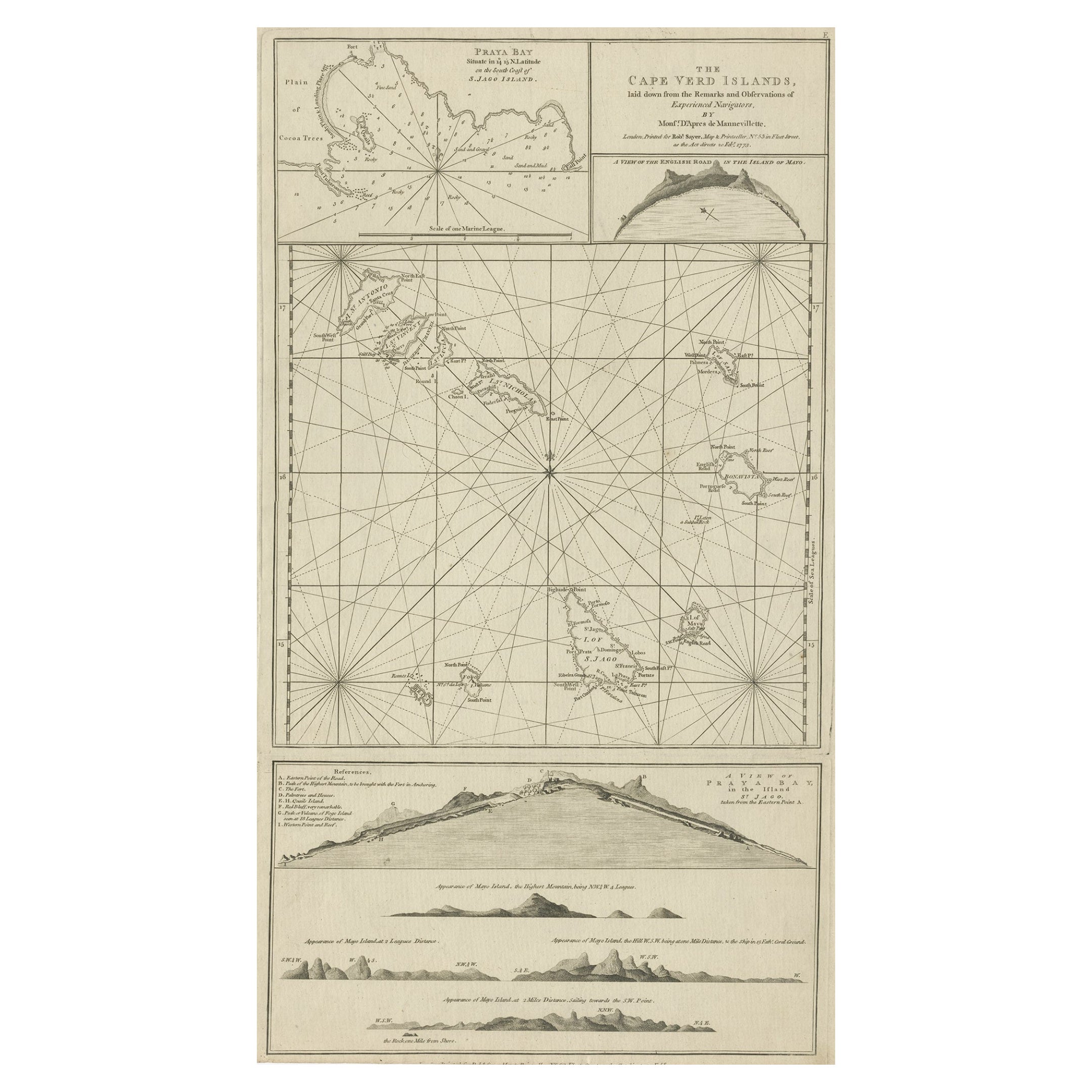
View AllMap & Views of the Cape Verde Islands, in the Atlantic Ocean, West-Africa, 1775
Located in Langweer, NL
Various maps and views on one plate titled 'Praya Bay (..)', 'The Cape Verd Islands (..)' and 'A view of Praya Bay (..)'.
Map and views of the Cape Verde islands, in the Atlantic Ocean west of Africa. Printed from two copper plates, published for Robert Sayer...
Category
Antique 1770s Maps
Materials
Paper
$602 Sale Price
20% Off
Original Antique Map of the Cape Verde Islands, 1746
Located in Langweer, NL
Antique map titled 'Carte Des Isles Du Cap Verd.' Original antique map of the Cape Verde Islands. Decorative cartouche and compass rose. Extends from Isle d...
Category
Antique 18th Century Maps
Materials
Paper

$162 Sale Price
20% Off
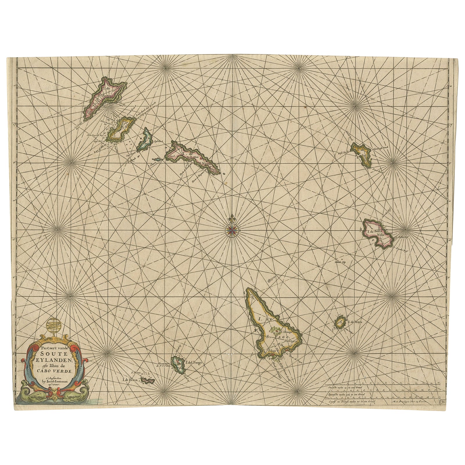
Antique Map of the Cape Verde Islands, Africa, ca.1670
Located in Langweer, NL
Antique map titled 'Pascaert van de Soute Eylanden ofte Ilhas de Cabo Verde'.
This map depicts the Cape Verde Islands (Africa). Islands titled 'Ile de B...
Category
Antique 1670s Maps
Materials
Paper
$631 Sale Price
20% Off
Antique Map of the Friendly Islands by Cook, 1803
Located in Langweer, NL
Antique map Friendly Islands titled 'Kaart van de Vrienden-Eilanden'. Antique map of the Friendly Islands depicting Rotterdam or Anamocka, Middelburg or Eaoowe and Amsterdam or Tonga...
Category
Antique 19th Century Maps
Materials
Paper

$205 Sale Price
20% Off
Antique Map of the Friendly Islands by Cook, 1803
Located in Langweer, NL
Antique map Friendly Islands titled 'Kaart van de Vrienden Eilanden'. Antique map of the Friendly Islands depicting Rotterdam or Anamocka, Middelburg or Eaoowe and Amsterdam or Tonga...
Category
Antique 19th Century Maps
Materials
Paper

$205 Sale Price
20% Off
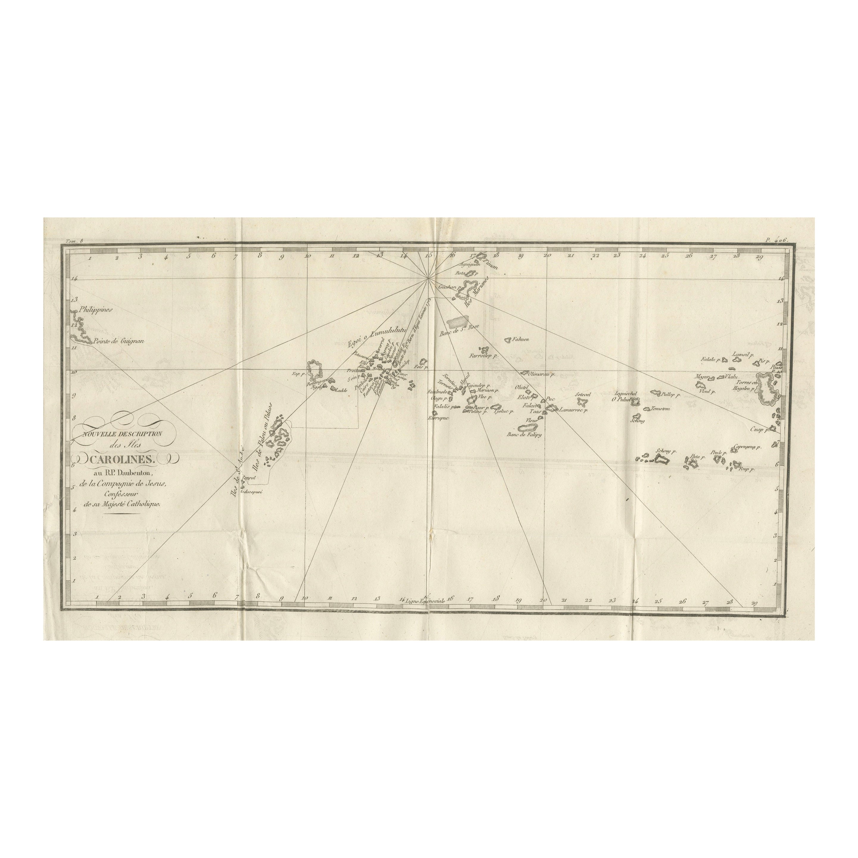
Antique Map of the Caroline Islands – Early Exploration of the Pacific, c.1760
Located in Langweer, NL
Map of the Caroline Islands – “Nouvelle Description des Isles Carolines”, c.1760
This 18th-century copperplate map, titled Nouvelle Description des Isles Carolines, charts the Carol...
Category
Antique Mid-18th Century French Maps
Materials
Paper
You May Also Like
Large Original Antique Map of The Canary Islands. 1894
Located in St Annes, Lancashire
Superb Antique map of The Canary Islands
Published Edward Stanford, Charing Cross, London 1894
Original colour
Good condition
Unframed.
Free shipping
Category
Antique 1890s English Maps
Materials
Paper

Large Original Antique Map of The Leeward Islands. 1894
Located in St Annes, Lancashire
Superb Antique map of The Leeward Islands
Published Edward Stanford, Charing Cross, London 1894
Original colour
Good condition
Unframed.
Free shipping
Category
Antique 1890s English Maps
Materials
Paper

19th Century Nautical Chart of Martinique
Located in Norwell, MA
Original map of Martinique from 1887 with chartered waters around the island. Prepared from a French survey, completed in 1825, showing town, ports, rivers and tributaries. Published...
Category
Antique 19th Century Nautical Objects

1865 Chart of the Islands of Madeira
Located in Norwell, MA
Rare James Imray chart from 1865 titled "Chart of the Islands of Madeira, Porto Santo and Dezerea" drawn from the survey made by Captain Ate Vidal Royal Navy, London. Published by Ja...
Category
Antique 1860s European Maps
Materials
Paper

Very Large Hand-Drawn View of St Iago Cape Verde, by Frederici, 1783
Located in Amsterdam, NL
Johann Christian Friderici [= Frederici] (Heldburg 1766 - Cape Town 1804)
Prospect van het eyland, en de rheede van St. Iago. Geteekend van Johann Christian Friderici / Verbeelding van de inwoonders op St Iago
(View of the island, and the roadstead of St. Iago. Drawn by Johann Christian Friderci / Depiction of the inhabitants on St Iago)
?Porto Praia, Cape Verde...
Category
Antique Late 18th Century Cape Verdean Dutch Colonial Maps
Materials
Paper

Captain Cook's Exploration of Tahiti: 18th C. Hand-colored Map by Bellin
By Jacques-Nicolas Bellin
Located in Alamo, CA
This beautiful 18th century hand-colored copper plate engraved map is entitled "Carte de l'Isle de Taiti, par le Lieutenant J. Cook" was created by Jacques Nicolas Bellin and publish...
Category
Late 18th Century Landscape Prints
Materials
Engraving

More Ways To Browse
Cape Antique Furniture
Antique St Nicholas
Painted Bar Stools
3x5 Rugs
Tufted Bar
Green Oushak
Pelle Pelle Leather
Antique Marble Top Hall Table
Bent Plywood
Antique Column Base
Bureau Desk
Low Black Coffee Table
Porcelain Modern Hand Painted
Dining Tables With Brass Inlay
Louis Marble Top Side Table
Palace Size Carpet
Armchair In France
Blue Kilim Vintage