Items Similar to New York State Antique Map c.1888 – The Empire State, Railroads & Counties


Video Loading
Want more images or videos?
Request additional images or videos from the seller
1 of 11
New York State Antique Map c.1888 – The Empire State, Railroads & Counties
$546.77
£407.17
€460
CA$754.89
A$836.90
CHF 439.83
MX$10,242.34
NOK 5,492.98
SEK 5,155.71
DKK 3,502.29
About the Item
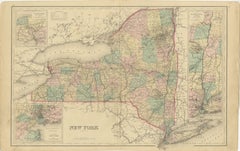
Antique Map of New York State – Rand McNally, circa 1888
This antique map of New York State was published by Rand, McNally & Co. around 1888. Unlike the sectional plates, this general map presents the entire state on a single sheet, providing an excellent overview of New York’s geography, cities, and extensive transportation system during the late 19th century.
The map stretches from Buffalo on Lake Erie to the Adirondacks and Lake Champlain, and from the Canadian border down through the Hudson River Valley to New York City and Long Island. The state’s counties are clearly delineated, with towns, rivers, and mountain ranges finely engraved.
Railroads, shown in red and blue, form an intricate web connecting the major industrial and commercial centers—Buffalo, Rochester, Syracuse, Albany, and New York City. The Erie Canal corridor, already one of the most important trade routes in America, is also well represented.
An inset of New York City provides further detail of the metropolitan area, showing Manhattan, Brooklyn, and surrounding boroughs before the 1898 consolidation of Greater New York. This makes the map not only geographically comprehensive but also historically significant for its urban detail.
Rand McNally’s maps combined accuracy with practicality, and this statewide edition captures New York at a time of industrial might and expanding infrastructure. It is particularly appealing for collectors of American cartography, New York history, and 19th-century transportation development.
Condition report:
Very good condition with even toning. Original center fold as issued with slight darkening along the crease. Clean margins with minimal handling wear. Strong impression with excellent detail.
Framing tips:
This map is ideal for display in a black or walnut frame with a cream mat. A double mat with ivory outer and muted blue inner will emphasize New York’s lakes and waterways, while also drawing attention to the New York City inset.
Technique: Lithograph with original outline color
Maker: Rand, McNally & Co., Chicago, circa 1888
- Dimensions:Height: 14.18 in (36 cm)Width: 20.67 in (52.5 cm)Depth: 0.01 in (0.2 mm)
- Materials and Techniques:Paper,Engraved
- Place of Origin:
- Period:
- Date of Manufacture:1888
- Condition:Very good condition with even toning. Original center fold as issued with slight darkening along the crease. Clean margins with minimal handling wear. Strong impression with excellent detail.
- Seller Location:Langweer, NL
- Reference Number:Seller: BG-12794-161stDibs: LU3054346475492
About the Seller
5.0
Recognized Seller
These prestigious sellers are industry leaders and represent the highest echelon for item quality and design.
Platinum Seller
Premium sellers with a 4.7+ rating and 24-hour response times
Established in 2009
1stDibs seller since 2017
2,609 sales on 1stDibs
Typical response time: <1 hour
- ShippingRetrieving quote...Shipping from: Langweer, Netherlands
- Return Policy
Authenticity Guarantee
In the unlikely event there’s an issue with an item’s authenticity, contact us within 1 year for a full refund. DetailsMoney-Back Guarantee
If your item is not as described, is damaged in transit, or does not arrive, contact us within 7 days for a full refund. Details24-Hour Cancellation
You have a 24-hour grace period in which to reconsider your purchase, with no questions asked.Vetted Professional Sellers
Our world-class sellers must adhere to strict standards for service and quality, maintaining the integrity of our listings.Price-Match Guarantee
If you find that a seller listed the same item for a lower price elsewhere, we’ll match it.Trusted Global Delivery
Our best-in-class carrier network provides specialized shipping options worldwide, including custom delivery.More From This Seller
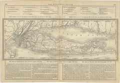
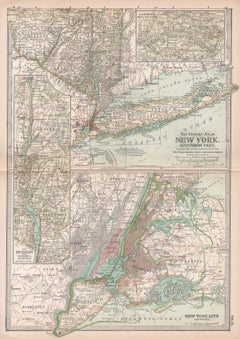
View AllLong Island New York Antique Map c.1888 – The Empire State, Railroads
Located in Langweer, NL
Antique Map of Long Island, New York – Rand McNally, circa 1888
This antique map of Long Island, New York, was published by Rand, McNally & Co. around 1888. Taken from their late 19...
Category
Antique Late 19th Century American Maps
Materials
Paper
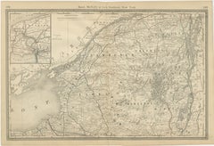
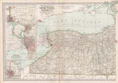
Antique Map of Northern New York – Rand McNally, circa 1888
Located in Langweer, NL
Antique Map of Northern New York – Rand McNally, circa 1888
This antique map of northern New York was published by Rand, McNally & Co. around 1888. Taken from one of their late 19th...
Category
Antique Late 19th Century American Maps
Materials
Paper
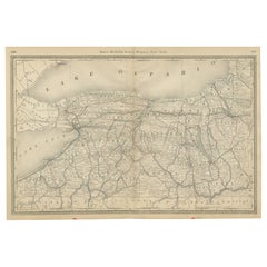
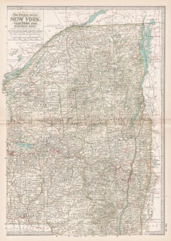
Western New York Antique Map – The Empire State, Railroads & Counties, c.1888
Located in Langweer, NL
Antique Map of Western New York – Rand McNally, circa 1888
This antique map of western New York was published by Rand, McNally & Co. around 1888. It presents a detailed view of the ...
Category
Antique Late 19th Century American Maps
Materials
Paper
1864 Johnson's Map of New York State with City Insets
Located in Langweer, NL
Title: 1864 Johnson's Map of New York State with City Insets
Description: This 1864 map, titled "Johnson's New York," was published by Johnson and Ward and features a detailed depic...
Category
Antique 1860s Maps
Materials
Paper

$266 Sale Price
20% Off
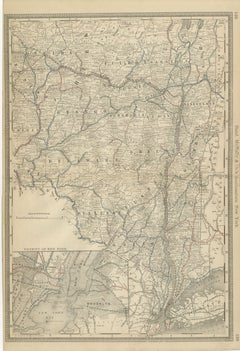
Antique Map of Southeastern New York – Rand McNally, circa 1888
Located in Langweer, NL
Antique Map of Southeastern New York – Rand McNally, circa 1888
This antique map of southeastern New York was published by Rand, McNally & Co. around 1888. It offers a detailed depi...
Category
Antique Late 19th Century American Maps
Materials
Paper
1876 Antique Map of New York State with Niagara and Hudson River Insets
Located in Langweer, NL
Title: Detailed Map of New York State - 1876 by Samuel Augustus Mitchell Jr.
Description: This is a hand-colored map of the state of New York from 1876, created by Samuel Augustus ...
Category
Antique 1870s Maps
Materials
Paper
$209 Sale Price
20% Off
You May Also Like
Original Antique Map of the American State of New York ( Western Part ) 1903
Located in St Annes, Lancashire
Antique map of New York ( Western Part )
Published By A & C Black. 1903
Original colour
Good condition
Unframed.
Free shipping
Category
Antique Early 1900s English Maps
Materials
Paper

New York. Southern Part. USA. Century Atlas state antique vintage map
Located in Melbourne, Victoria
'The Century Atlas. New York. Southern Part.'
Original antique map, 1903.
Inset maps of 'New York City and Vicinity' and 'The Hudson'.
Central fold as issued. Map name and number p...
Category
Early 20th Century Victorian More Prints
Materials
Lithograph
New York, Western Part. USA. Century Atlas state antique vintage map
Located in Melbourne, Victoria
'The Century Atlas. New York, Western Part'
Original antique map, 1903.
Central fold as issued. Map name and number printed on the reverse corners.
Sheet 29.5cm by 40cm.
Category
Early 20th Century Victorian More Prints
Materials
Lithograph
New York. Northern and Eastern Part. USA Century Atlas state antique vintage map
Located in Melbourne, Victoria
'The Century Atlas. New York. Northern and Eastern Part'
Original antique map, 1903.
Central fold as issued. Map name and number printed on the reverse corners.
Sheet 40cm by 29.5c...
Category
Early 20th Century Victorian More Prints
Materials
Lithograph
1858 Colton's Map of New York, Ric.B011
Located in Norton, MA
An 1858 Colton's map of New York
Ric.b011
Colton’s New York, 1858 - A large original color engraved and very detailed map of the state of New York,...
Category
Antique 19th Century Unknown Maps
Materials
Paper

Original Antique Map of the American State of New York ( Southern Part ) 1903
Located in St Annes, Lancashire
Antique map of New York ( Southern Part )
Published By A & C Black. 1903
Original colour
Good condition
Unframed.
Free shipping
Category
Antique Early 1900s English Maps
Materials
Paper
