Items Similar to Old Map of the Bangka Belitun Islands, Greater Sunda Islands, Indonesia, 1705


Want more images or videos?
Request additional images or videos from the seller
1 of 5
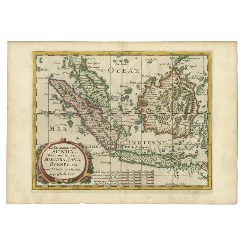
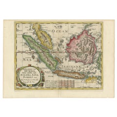
Old Map of the Bangka Belitun Islands, Greater Sunda Islands, Indonesia, 1705
About the Item
Antique map Sunda Islands titled 'De Eilanden van Sunda, waar onder zyn Sumatra, Java, Borneo enz'.
Old map of the Bangka Belitun Islands, part of the Greater Sunda Islands, including present-day Java, Sumatra, Borneo, part of Malaysia. Includes settlements picked out in gold, scales, and indication of shallows. This map originates from 'Algemeene weereld-beschryving, nae de rechte verdeeling der landschappen (..)' published by F. Halma.
Artists and Engravers: Engraved by A. de Winter.
Condition: Very good, please study image carefully.
- Dimensions:Height: 8.86 in (22.5 cm)Width: 12.6 in (32 cm)Depth: 0 in (0.02 mm)
- Materials and Techniques:
- Period:1700-1709
- Date of Manufacture:1705
- Condition:
- Seller Location:Langweer, NL
- Reference Number:
About the Seller
5.0
Platinum Seller
These expertly vetted sellers are 1stDibs' most experienced sellers and are rated highest by our customers.
Established in 2009
1stDibs seller since 2017
1,929 sales on 1stDibs
Typical response time: <1 hour
- ShippingRetrieving quote...Ships From: Langweer, Netherlands
- Return PolicyA return for this item may be initiated within 14 days of delivery.
More From This SellerView All
- Antique Map of the Bangka Belitun Island by Sanson, 1705Located in Langweer, NLAntique map Sunda Islands titled 'De Eilanden van Sunda, waar onder zyn Sumatra, Java, Borneo enz'. Old map of the Bangka Belitun Islands, part of the Greater Sunda Islands, includin...Category
Antique 18th Century Maps
MaterialsPaper
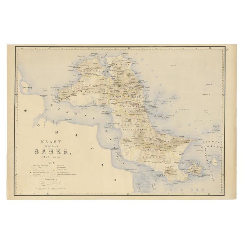
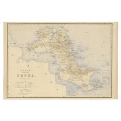
- Antique Map of Bangka Island, Indonesia, 1885Located in Langweer, NLAntique map titled 'Kaart van het Eiland Banka. Old map of Bangka Island, or Banka. This map originates from 'Atlas der Nederlandsche bezittingen in Oost-Indië naar de nieuwste bronn...Category
Antique 19th Century Maps
MaterialsPaper
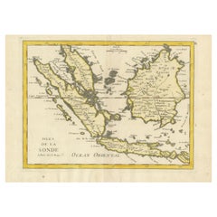
- Old Original Antique Map of the Sunda Islands of Indonesia, 1756Located in Langweer, NLTitle: Isles De La Sonde. Attractive old decorative map of the Isles de la Sonde, Borneo, Sumatra, Java and Malacca ( Malaysia) with the Straits of Malacca. Penang is spelled as P...Category
Antique 1750s Maps
MaterialsPaper
- Antique Map of the Sunda Islands Including Sumatra, Java, and Borneo, 1705Located in Langweer, NLTitle: “Antique Map of the Sunda Islands Including Sumatra, Java, and Borneo” This print is a beautifully detailed and relatively rare map of Western Indonesia, encompassing the reg...Category
Antique Early 1700s Maps
MaterialsPaper
- Antique Map of the Sunda Islands by Tirion 'c.1760'Located in Langweer, NLAntique map titled 'Nuova Carta delle Isole di Sunda come Borneo, Sumatra e Iava Grande'. Detailed map of the Sunda Islands, Southeast Asia, extending from the tip of Cambodia to Jav...Category
Antique Mid-18th Century Maps
MaterialsPaper
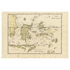
- Old Original Antique Map of the Islands of East Indonesia, 1756Located in Langweer, NLTitle: Isles Moluques. Old and rare, this decorative map of the Maluku Islands in the period it was still controlled by the Dutch colonial power. It also shows the island of Bali, Lombok, part of Borneo (Kalimantan), Celebes (Sulawesi), Timor, The Lesser Sunda Islands, West Papua...Category
Antique 1750s Maps
MaterialsPaper


You May Also Like
- 1705 Golfe de Mexico and Florida Framed MapLocated in Stamford, CTFramed map of Mexico & Florida circa 1705, Paris. Small map with Mexico and the Gulf Coast. Inset text indicating Panama, Acapulco, Mexico City and the Mississippi. Extends North to ...Category
Antique Early 1700s French Spanish Colonial Maps
MaterialsGlass, Wood, Paper
- Large Original Vintage Map of The Pacific Islands Including HawaiiLocated in St Annes, LancashireGreat map of The Pacific Islands Unframed Original color By John Bartholomew and Co. Edinburgh Geographical Institute Published, circa 1...Category
Vintage 1920s British Maps
MaterialsPaper
- Old Nautical Map of CorsicaLocated in Alessandria, PiemonteST/556/1 - Old map of Corsica isle, surveyed by Captain Hell, of the French Royal Navy in 1824, engraved and published on 1874, with additions and corre...Category
Antique Early 19th Century English Other Prints
MaterialsPaper
- Old Horizontal Map of EnglandBy TassoLocated in Alessandria, PiemonteST/520 - Old rare Italian map of England, dated 1826-1827 - by Girolamo Tasso, editor in Venise, for the atlas of M.r Le-Sage.Category
Antique Early 19th Century Italian Other Prints
MaterialsPaper
- 1868 Map of the Upper Part of the Island of Manhattan Above 86th StreetBy Wm. Rogers Mfg. Co.Located in San Francisco, CAThis wonderful piece of New York City history is over 150 years old. It depicts 86th street and above. It was lithographed by WC Rogers and company. It was made to show what was the Battle of Harlem during the Revolutionary war...Category
Antique 1860s American American Colonial Maps
MaterialsPaper
- 1854 Map of Massachusetts, Connecticut and Rhode Island, Antique Wall MapLocated in Colorado Springs, COThis striking wall map was published in 1854 by Ensign, Bridgman & Fanning and has both full original hand-coloring and original hardware. This impression is both informative and highly decorative. The states are divided into counties, outlined in red, green, and black, and subdivided into towns. Roads, canals, and railroad lines are prominently depicted, although they are not all labeled. The mapmakers also marked lighthouses, banks, churches, and prominent buildings, with a key at right. The map is an informative and comprehensive overview of the infrastructural development of New England prior to the Civil War. Physical geographies depicted include elevation, conveyed with hachure marks, rivers and lakes. The impression features an inset map of Boston...Category
Antique 19th Century American Maps
MaterialsPaper


Recently Viewed
View AllMore Ways To Browse
Antique Island Furniture
Scale Map
Indonesia Map
Antique Map Indonesia
Antique Maps Indonesia
Malaysia Gold
Borneo Antique
Antique Malaysia
Old Java
Java Map
Antique Furniture Malaysia
Malaysian Antique Furniture
Malaysian Antique
Malaysian Map
Malaysia Map
Antique House Plans
Antique Metal Window
Antique Metal Windows