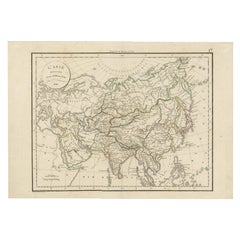
Items Similar to Original 1859 Map of Asia from W.G. Blackie's Imperial Atlas of Modern Geography


Want more images or videos?
Request additional images or videos from the seller
1 of 6
Original 1859 Map of Asia from W.G. Blackie's Imperial Atlas of Modern Geography
$238.10
$297.6220% Off
£176.97
£221.2120% Off
€200
€25020% Off
CA$328.75
CA$410.9320% Off
A$364.55
A$455.6920% Off
CHF 191.55
CHF 239.4320% Off
MX$4,454.24
MX$5,567.8020% Off
NOK 2,396.51
NOK 2,995.6320% Off
SEK 2,249.53
SEK 2,811.9120% Off
DKK 1,522.90
DKK 1,903.6220% Off
About the Item
Antique map titled 'Asia'. Original antique map of Asia. This map originates from ‘The Imperial Atlas of Modern Geography’. Published by W. G. Blackie, 1859.
The "Classic Cartographic Masterpiece: 1859 Asia" is an original antique map from W. G. Blackie's esteemed collection, 'The Imperial Atlas of Modern Geography', published in 1859. This map offers a comprehensive and detailed representation of the continent of Asia, as understood in the mid-19th century.
**Description of the Map:**
1. **Geographical Coverage**: The map encompasses the entire continent of Asia, detailing its vast and diverse landscapes. It includes regions from the Middle East to the far reaches of East Asia, and from the Arctic shores of Siberia to the islands of Southeast Asia.
2. **Topographical Features**: It showcases a variety of geographical features, such as mountain ranges, rivers, deserts, and plains, highlighting the continent's complex physical geography.
3. **Political Boundaries**: Reflecting the knowledge of the era, the map illustrates the political boundaries of different Asian countries and regions as they were recognized in the 1850s. This provides a historical perspective on the political landscape of Asia during that time.
4. **Cities and Important Landmarks**: Major cities, trade routes, and possibly historical landmarks are marked, offering insights into the cultural and economic centers of 19th-century Asia.
5. **Artistic and Aesthetic Elements**: True to the style of the period, the map likely features decorative elements, such as ornate borders and an elegant title script, enhancing its visual appeal.
6. **Educational Value**: As a historical document, this map is invaluable for educational purposes, providing a glimpse into 19th-century perceptions and knowledge of Asian geography.
**Description of 'The Imperial Atlas of Modern Geography':**
1. **Scope and Content**: This atlas was a comprehensive collection of maps, covering various regions of the world. It was known for its detailed and accurate representations of different continents, countries, and regions as understood in the mid-19th century.
2. **Quality and Craftsmanship**: The maps in this atlas were crafted with a high level of detail and accuracy, reflecting the advanced cartographic techniques and geographical knowledge of the time.
3. **Historical Significance**: 'The Imperial Atlas of Modern Geography' is considered an important historical document, providing insights into the state of geographical knowledge and perceptions during the Victorian era.
4. **Audience and Usage**: The atlas was likely used for educational, reference, and navigational purposes, serving as an important tool for scholars, educators, and navigators of the time.
This antique map of Asia, along with the entire collection in 'The Imperial Atlas of Modern Geography', represents a significant piece of cartographic history, offering both historical and aesthetic value for collectors, historians, and map enthusiasts.
- Dimensions:Height: 14.57 in (37 cm)Width: 21.26 in (54 cm)Depth: 0.02 in (0.5 mm)
- Materials and Techniques:
- Period:
- Date of Manufacture:1859
- Condition:Wear consistent with age and use. General age-related toning. some foxing, Please study image carefully.
- Seller Location:Langweer, NL
- Reference Number:Seller: BG-12685-1-381stDibs: LU3054325240452
About the Seller
5.0
Recognized Seller
These prestigious sellers are industry leaders and represent the highest echelon for item quality and design.
Platinum Seller
Premium sellers with a 4.7+ rating and 24-hour response times
Established in 2009
1stDibs seller since 2017
2,609 sales on 1stDibs
Typical response time: <1 hour
- ShippingRetrieving quote...Shipping from: Langweer, Netherlands
- Return Policy
Authenticity Guarantee
In the unlikely event there’s an issue with an item’s authenticity, contact us within 1 year for a full refund. DetailsMoney-Back Guarantee
If your item is not as described, is damaged in transit, or does not arrive, contact us within 7 days for a full refund. Details24-Hour Cancellation
You have a 24-hour grace period in which to reconsider your purchase, with no questions asked.Vetted Professional Sellers
Our world-class sellers must adhere to strict standards for service and quality, maintaining the integrity of our listings.Price-Match Guarantee
If you find that a seller listed the same item for a lower price elsewhere, we’ll match it.Trusted Global Delivery
Our best-in-class carrier network provides specialized shipping options worldwide, including custom delivery.More From This Seller
View AllAntique Map of Asia by A & C, Black, 1870
Located in Langweer, NL
Antique map titled 'Asia'. Original antique map of Asia. This map originates from ‘Black's General Atlas of The World’. Published by A & C. Black, 1870.
Category
Antique Late 19th Century Maps
Materials
Paper

$238 Sale Price
20% Off
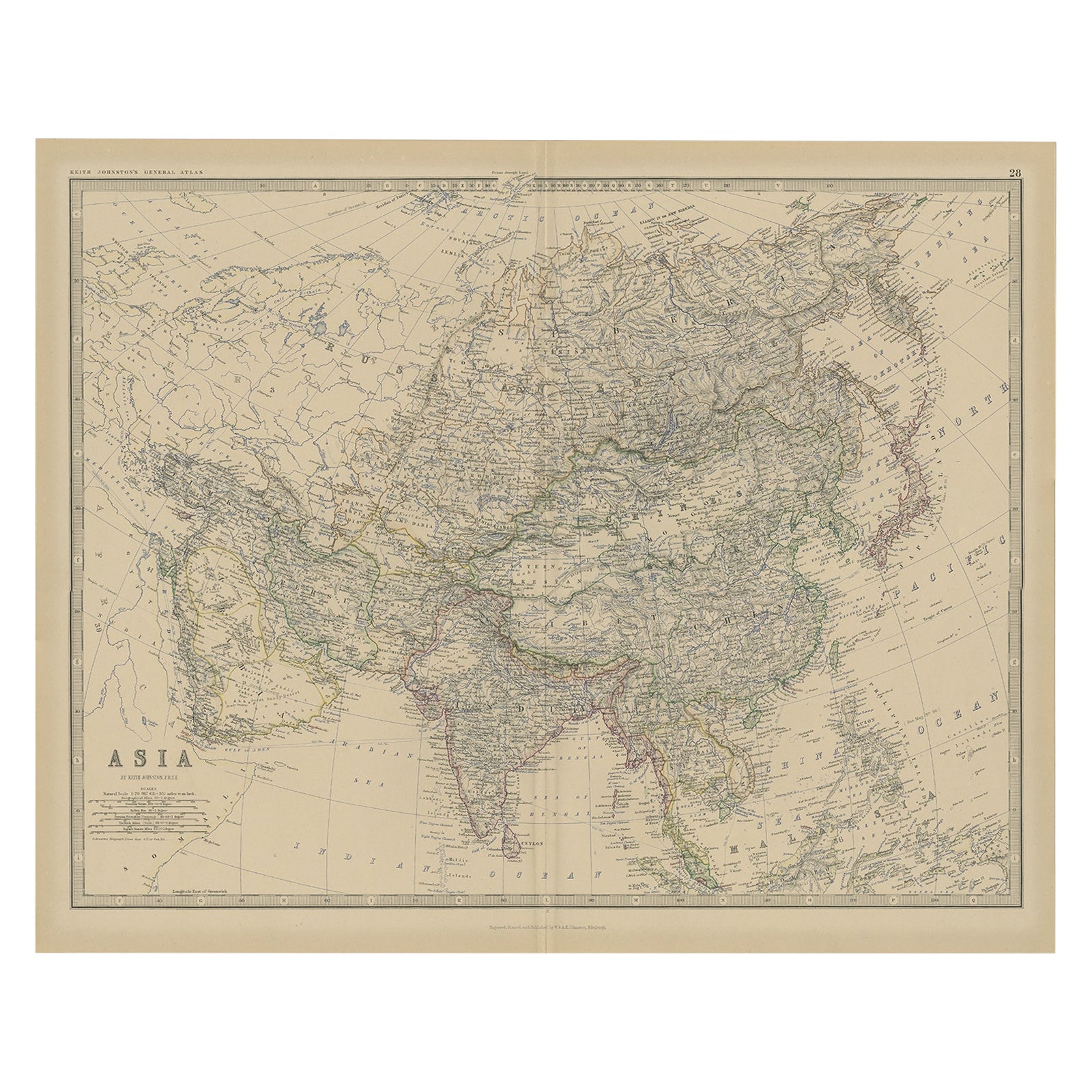
Antique Map of Asia by K. Johnston, circa 1879
Located in Langweer, NL
No. 28 of Keith Johnston's General Atlas. Published by William Blackwood & Sons Edinburgh & London, circa 1879.
Category
Antique Late 19th Century Maps
Materials
Paper

$252 Sale Price
20% Off
Antique Map of Asia from a German School Atlas, c.1870
Located in Langweer, NL
Antique map titled 'Asien'. Old map of the Asian continent. This map originates from 'H. Kiepert's Kleiner Atlas der Neueren Geographie für Schule und Haus'.
Artists and Engravers:...
Category
Antique 19th Century Maps
Materials
Paper

$136 Sale Price
20% Off
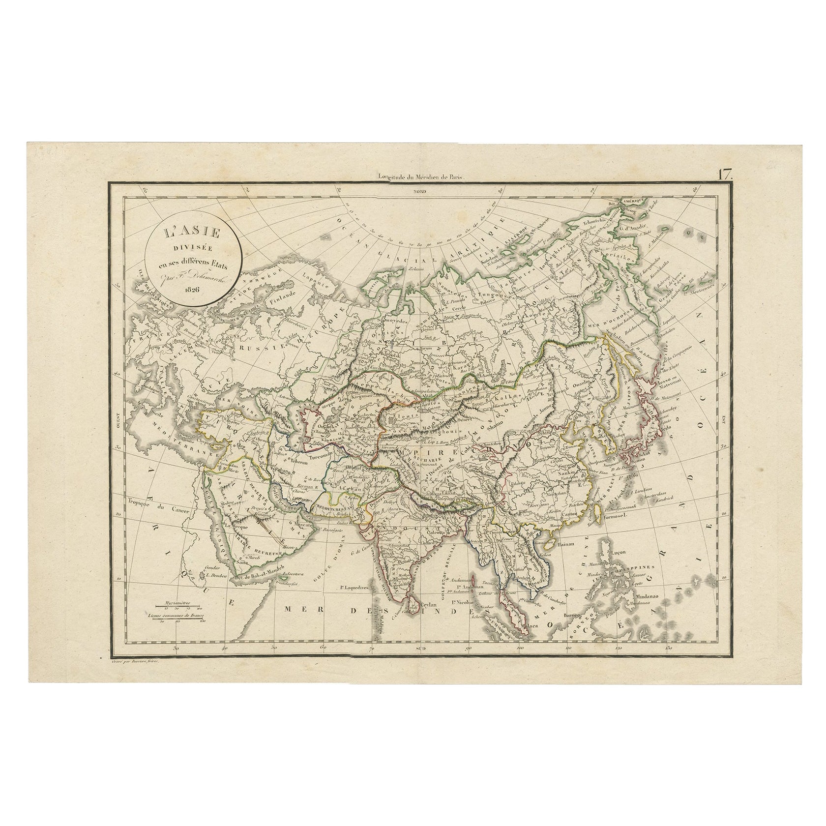
Antique Map of Asia by Delamarche, 1826
Located in Langweer, NL
Vaugondy's map plates and copyrights and later addes many plates from other sources as well. Charles Delamarche eventually passed control of the firm to his son Felix Delamarche (18t...
Category
Antique 19th Century Maps
Materials
Paper
$228 Sale Price
20% Off
Large Antique Map of Asia The Royal Atlas of Modern Geography by Johnston, 1882
Located in Langweer, NL
Antique map titled 'Asia'. Old map of the Asian continent. This map originates from 'The Royal Atlas of Modern Geography, Exhibiting, in a Series of Entirely Original and Authentic M...
Category
Antique 19th Century Maps
Materials
Paper
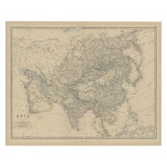
$276 Sale Price
20% Off
Antique Map of Asia by Lapie, 1842
Located in Langweer, NL
Antique map titled 'Carte de l'Asie'. Map of Asia. This map originates from 'Atlas universel de géographie ancienne et moderne (..)' by Pierre M. Lapie and...
Category
Antique Mid-19th Century Maps
Materials
Paper

$571 Sale Price
20% Off
You May Also Like
Antique 1803 Italian Map of Asia Including China Indoneseia India
Located in Amsterdam, Noord Holland
Antique 1803 Italian Map of Asia Including China Indoneseia India
Very nice map of Asia. 1803.
Additional information:
Type: Map
Country of Manufacturing: Europe
Period: 19th centu...
Category
Antique 19th Century European Maps
Materials
Paper

$584 Sale Price
20% Off
Large Original Antique Map of Asia by Sidney Hall, 1847
Located in St Annes, Lancashire
Great map of Asia
Drawn and engraved by Sidney Hall
Steel engraving
Original colour outline
Published by A & C Black. 1847
Unframed
Free shipping
Category
Antique 1840s Scottish Maps
Materials
Paper

Original Antique Map of China, Arrowsmith, 1820
Located in St Annes, Lancashire
Great map of China
Drawn under the direction of Arrowsmith
Copper-plate engraving
Published by Longman, Hurst, Rees, Orme and Brown, 1820
Unfr...
Category
Antique 1820s English Maps
Materials
Paper

Large Original Vintage Map of S.E Asia, with a Vignette of Singapore
Located in St Annes, Lancashire
Great map of South East Asia
Original color. Good condition
Published by Alexander Gross
Unframed.
Category
Vintage 1920s English Maps
Materials
Paper

Super Rare Antique French Map of Chine and the Chinese Empire, 1780
Located in Amsterdam, Noord Holland
Super Rare Antique French Map of Chine and the Chinese Empire, 1780
Very nice map of Asia. 1780 Made by Bonne.
Additional information:
Type: Map
...
Category
Antique 18th Century European Maps
Materials
Paper

$584 Sale Price
32% Off
Original Antique Map of The Eastern Hemisphere by Dower, circa 1835
Located in St Annes, Lancashire
Nice map of the Eastern Hemisphere
Drawn and engraved by J.Dower
Published by Orr & Smith. C.1835
Unframed.
Free shipping
Category
Antique 1830s English Maps
Materials
Paper

More Ways To Browse
Historical Documents
Imperial Mid
World Map Of Trade Routes
Persian Maps
Antique Railroad Collectibles
Gold Maps
Large Map Of Italy
Map Tuscany
World Map Of Trade Routes
Antique Map Of Switzerland
Albanian Antique
Antique Mediterranean Map
West Indies Antique Furniture
Antique Map Paris
Antique Pamphlets
Antique Map Mexico
Antique Puerto Rico
Antique Map Ortelius