
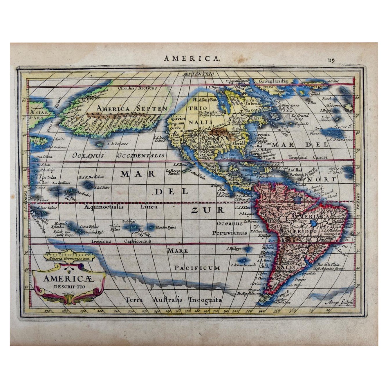
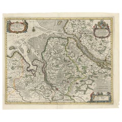
Rare 17th Century American Map of Virginia and Florida by Jan Janssonius
View Similar Items


Want more images or videos?
Request additional images or videos from the seller
1 of 2
Rare 17th Century American Map of Virginia and Florida by Jan Janssonius
About the Item
- Creator:Jan Johansson (Maker)
- Dimensions:Height: 25.25 in (64.14 cm)Width: 30.25 in (76.84 cm)Depth: 2 in (5.08 cm)
- Style:Rococo (Of the Period)
- Place of Origin:
- Period:
- Date of Manufacture:1650
- Condition:measurements are framed.
- Seller Location:Wiscasset, ME
- Reference Number:1stDibs: LU101761253860
About the Seller
5.0
Gold Seller
Premium sellers maintaining a 4.3+ rating and 24-hour response times
Established in 1998
1stDibs seller since 2013
216 sales on 1stDibs
Typical response time: 1 hour
Authenticity Guarantee
In the unlikely event there’s an issue with an item’s authenticity, contact us within 1 year for a full refund. DetailsMoney-Back Guarantee
If your item is not as described, is damaged in transit, or does not arrive, contact us within 7 days for a full refund. Details24-Hour Cancellation
You have a 24-hour grace period in which to reconsider your purchase, with no questions asked.Vetted Professional Sellers
Our world-class sellers must adhere to strict standards for service and quality, maintaining the integrity of our listings.Price-Match Guarantee
If you find that a seller listed the same item for a lower price elsewhere, we’ll match it.Trusted Global Delivery
Our best-in-class carrier network provides specialized shipping options worldwide, including custom delivery.More From This Seller
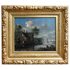
View All"Village by the Lake" 17th Century Old Master School of Thomas Heeremans
Located in Wiscasset, ME
Old master painting featuring a busy port city in the 17th century. Most likely Dutch and very close in style to the work of Thomas Heeremans. This is...
Category
Antique 17th Century Dutch Dutch Colonial Paintings
Materials
Paint
"Woodie Wagon Brooklyn Taxi" Sculpture by Paul Jacobsen
By Paul Jacobsen
Located in Wiscasset, ME
Custom sculpture constructed of painted wood.
Paul Jacobsen used everyday objects, such as chairs, cars, airplanes, trains, motorcycles and puzzles, all built from scratch and turns...
Category
2010s American Folk Art Sculptures and Carvings
Materials
Wood

$4,400 Sale Price
26% Off
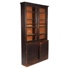
Early 19th Century American Painted Bookcase
Located in Wiscasset, ME
An early American painted bookcase of nice shallow dimension. From either New York or New England, of step back-form with a molded cornice over double glazed doors, over double cabi...
Category
Antique Early 19th Century American Colonial Bookcases
Materials
Wood, Paint
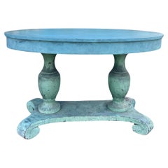
19th Century American Blue Painted Center Oval Table
Located in Wiscasset, ME
Early 19th century American table in fabulous early blue paint. Featuring a pair of bulbous urn supports set on a stretcher base with scroll carved feet. The color has a Swedish Gu...
Category
Antique Early 19th Century American Folk Art Center Tables
Materials
Wood, Paint
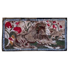
Late 19th Century American Hooked Rug with Lions
By Frost
Located in Wiscasset, ME
Frost pattern design from Maine, late 19th century. Museum mounted and ready to hang.
Category
Antique 1890s American Folk Art Rugs
Materials
Wool
Rare Norwegian Carved Tankard Featuring Gnomes, Mid-18th Century
Located in Wiscasset, ME
The entire tankard is surrounded by a family of gnomes. Early peg construction, in excellent overall condition. Fair bet that you'll never see another one like this!
Category
Antique 1760s Norwegian Folk Art Sculptures and Carvings

You May Also Like
17th Century Hand-Colored Map of a Region in West Germany by Janssonius
By Johannes Janssonius
Located in Alamo, CA
This attractive highly detailed 17th century original hand-colored map is entitled "Archiepiscopatus Maghdeburgensis et Anhaltinus Ducatus cum terris adjacentibus". It was published ...
Category
Antique Mid-17th Century Dutch Maps
Materials
Paper

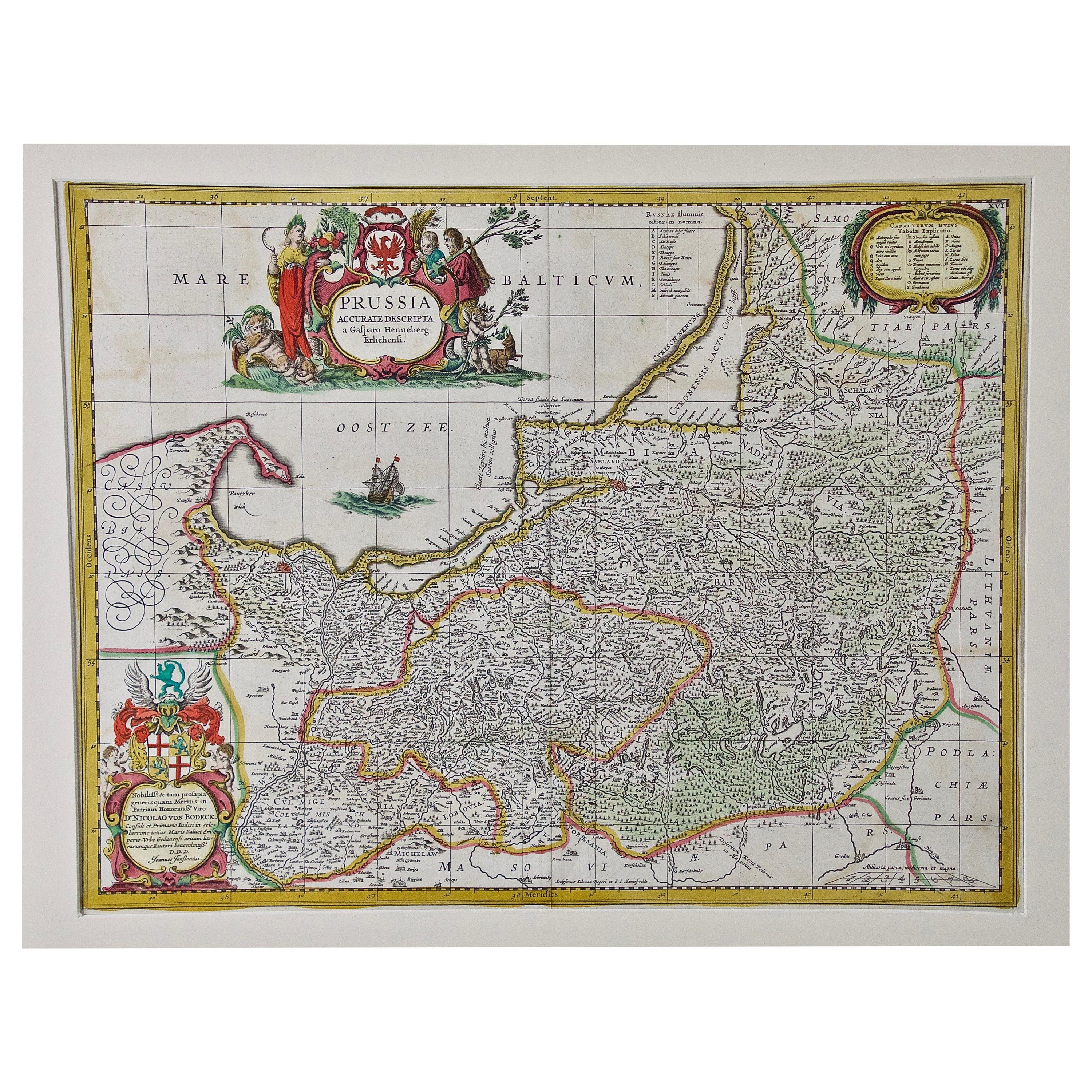
Prussia, Poland, N. Germany, Etc: A Hand-colored 17th Century Map by Janssonius
By Johannes Janssonius
Located in Alamo, CA
This is an attractive hand-colored copperplate engraved 17th century map of Prussia entitled "Prussia Accurate Descripta a Gasparo Henneberg Erlichensi", published in Amsterdam by Joannes Janssonius in 1664. This very detailed map from the golden age of Dutch cartography includes present-day Poland, Latvia, Lithuania, Estonia and portions of Germany. This highly detailed map is embellished by three ornate pink, red, mint green and gold...
Category
Antique Mid-17th Century Dutch Maps
Materials
Paper

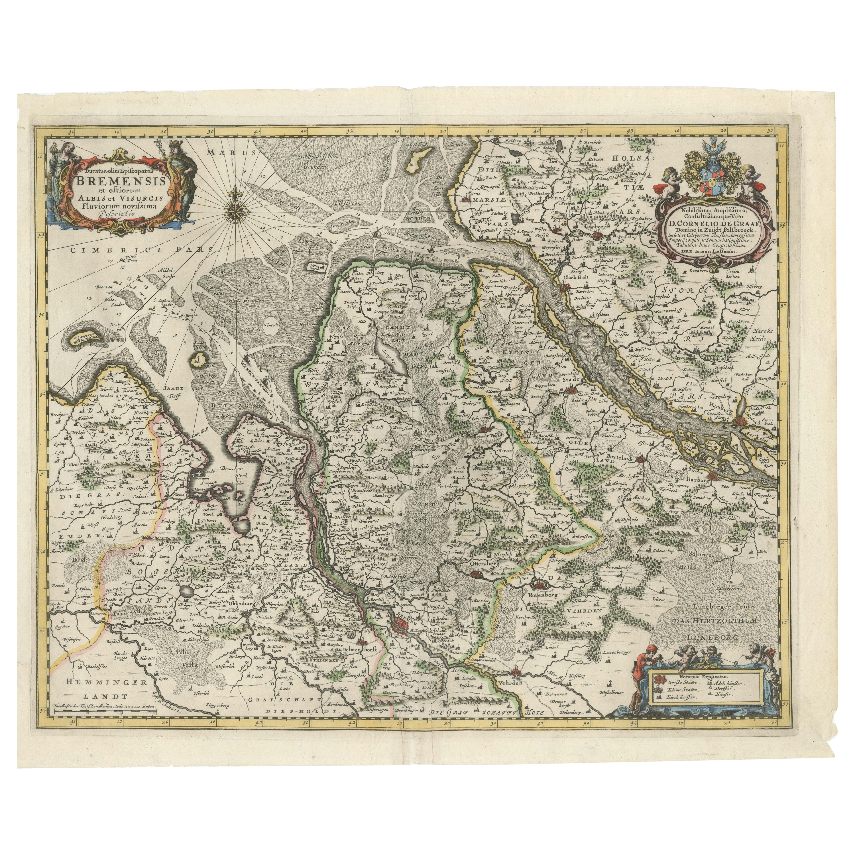
Johannes Janssonius' 17th-Century Map of the Duchy of Bremen in Germany
Located in Langweer, NL
The map titled "Ducatus olim Episcopatus Bremensis et ostiorum Albis et Visurgis Fluviorum novissima Descriptio" by Johannes Janssonius provides a rich historical and geographical il...
Category
Antique 1650s Maps
Materials
Paper
$717 Sale Price
20% Off
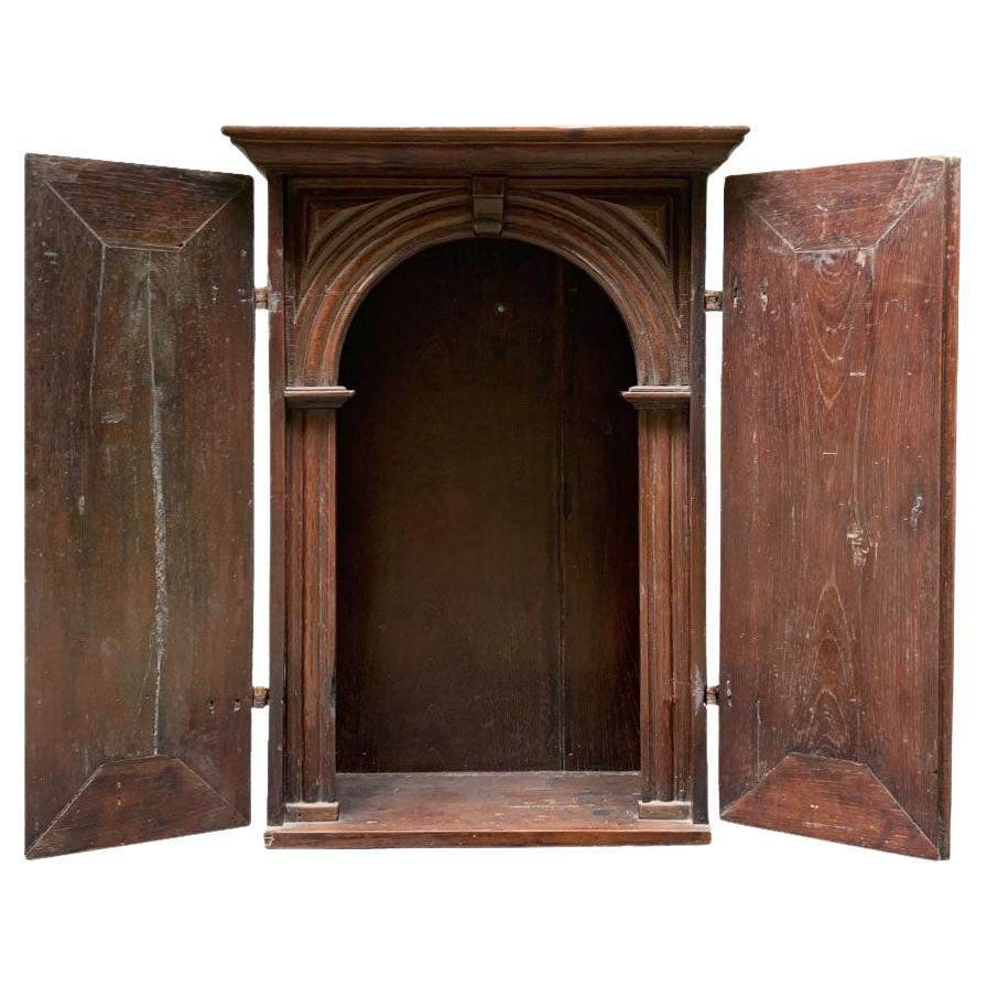
Rare 17th Century South American Shrine
Located in Rio De Janeiro, BR
Rare 17th Century Cedar Shrine.
Straight box with padded doors. Interior with decorative arch in the shape of a portal.
Dimensions in centimeters: 52cm W x 26,50 cm D x 71 cm H.
Th...
Category
Antique Late 17th Century Brazilian Baroque Religious Items
Materials
Cedar
Vintage Reproduction 17th Century Map of Europe, American, Cartography, Blaeuw
Located in Hele, Devon, GB
This is a vintage reproduction map of Europe. An American, paper stock cartography print in frame after the work by Blaeuw, dating to the late 20t...
Category
Late 20th Century Central American Mid-Century Modern Maps
Materials
Glass, Wood, Paper

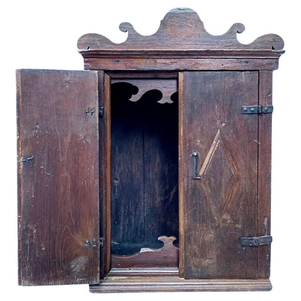
Rare 17th Century South American Colonial Shrine
Located in Rio De Janeiro, BR
Rare 17th Century South American Colonial Shrine
Straight box with pediment cut into stylized volutes. Made of polished cedar, with wrought iron fittings, this oratory reflects the ...
Category
Antique Late 17th Century Brazilian Baroque Religious Items
Materials
Cedar
Recently Viewed
View AllMore Ways To Browse
Johansson Soner
18th Century Virginia
Virginia Map
Antique Maps Virginia
Antique Florida Map
Map Of Arabia
New Zealand Map
Map Tibet
Antique Map Of Egypt
British Empire Map
18th Century French Globe
Antique Map Ortelius
Antique Nautical Maps
Roman Empire Map
Voc Ship
16th Century Globe
Map Of Singapore
Antique Map Of Middle East