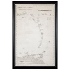
Rare Chart of the Caribbean Islands Published by James Imray & Son, London, 1866
View Similar Items


Want more images or videos?
Request additional images or videos from the seller
1 of 14
Rare Chart of the Caribbean Islands Published by James Imray & Son, London, 1866
About the Item
- Dimensions:Height: 44 in (111.76 cm)Width: 30 in (76.2 cm)Depth: 1.5 in (3.81 cm)
- Style:Folk Art (Of the Period)
- Materials and Techniques:
- Place of Origin:
- Period:
- Date of Manufacture:1866
- Condition:Wear consistent with age and use.
- Seller Location:Stamford, CT
- Reference Number:Seller: Avery & Dash - FW171stDibs: LU918619641752
About the Seller
4.9
Vetted Seller
These experienced sellers undergo a comprehensive evaluation by our team of in-house experts.
Established in 1999
1stDibs seller since 2011
525 sales on 1stDibs
Typical response time: 2 hours
More From This SellerView All
- Pair of Slipper Chairs in the style of James Mont.Located in Stamford, CTA pair of slipper chairs in the style of James Mont.Category
20th Century Slipper Chairs
MaterialsWood
- Chinese Guanyin Goddess of Compassion and MercyLocated in Stamford, CTA Chinese polychrome bronze depiction of Guanyin the Goddess of compassion and mercy. What makes this presentation more unique is the fact that G...Category
Antique Mid-19th Century Chinese Religious Items
MaterialsBronze
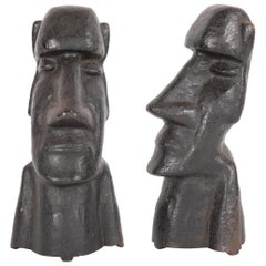
- 20th Century Cast Iron Andirons in the Form of the Easter Islands Stone StatuesLocated in Stamford, CTEarly 20th century cast iron andirons in the form of the Easter Islands stone statues. Andirons do not have backs, circa 1900-1920.Category
Early 20th Century Sculptures and Carvings
MaterialsIron
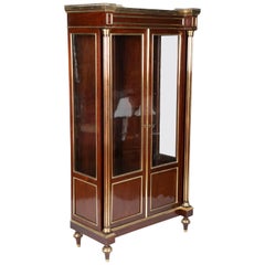
- Napoleon III Caribbean Mahogany Curio CabinetLocated in Stamford, CTNapoleon III Caribbean mahogany, brass-mounted and gilt curio cabinet, circa 1840.Category
Antique Mid-19th Century French Napoleon III Cabinets
MaterialsMahogany
- African Gnu SkullLocated in Stamford, CTAfrican Gnu skull can be wall-mounted or rest on a table top.Category
Mid-20th Century African Taxidermy
MaterialsBone
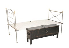
- Late 19th Century British Officer's Campaign Bed with Original Storage ChestLocated in Stamford, CTLate 19th century British Army officer's painted pine campaign chest containing original steel & brass campaign bed. Stand is modern as is bed canva...Category
Antique Late 19th Century English Campaign Daybeds
MaterialsSteel


You May Also Like
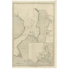
- Original Imray & Son Chart of North Atlantic, 1876Located in Norwell, MANautical chart of the North Atlantic showing the Eastern United States coast, Caribbean Islands, South America (Venezuela and ), British Possessions (Canada - Gulf of Lawrence, Newfo...Category
Antique 1870s Nautical Objects
MaterialsPaper
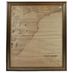
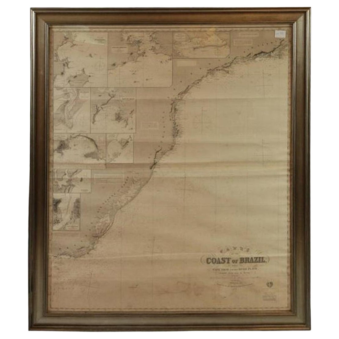
- Imray Ocean Chart of the Coast of Brazil 1876Located in Norwell, MAImray & Son 1876 Nautical chart of the Coast of Brazil between Cape Frio and the River Plate. Nicely framed. Overall Dimensions: 46" H x 56" W.Category
Antique 1870s Nautical Objects
MaterialsPaper
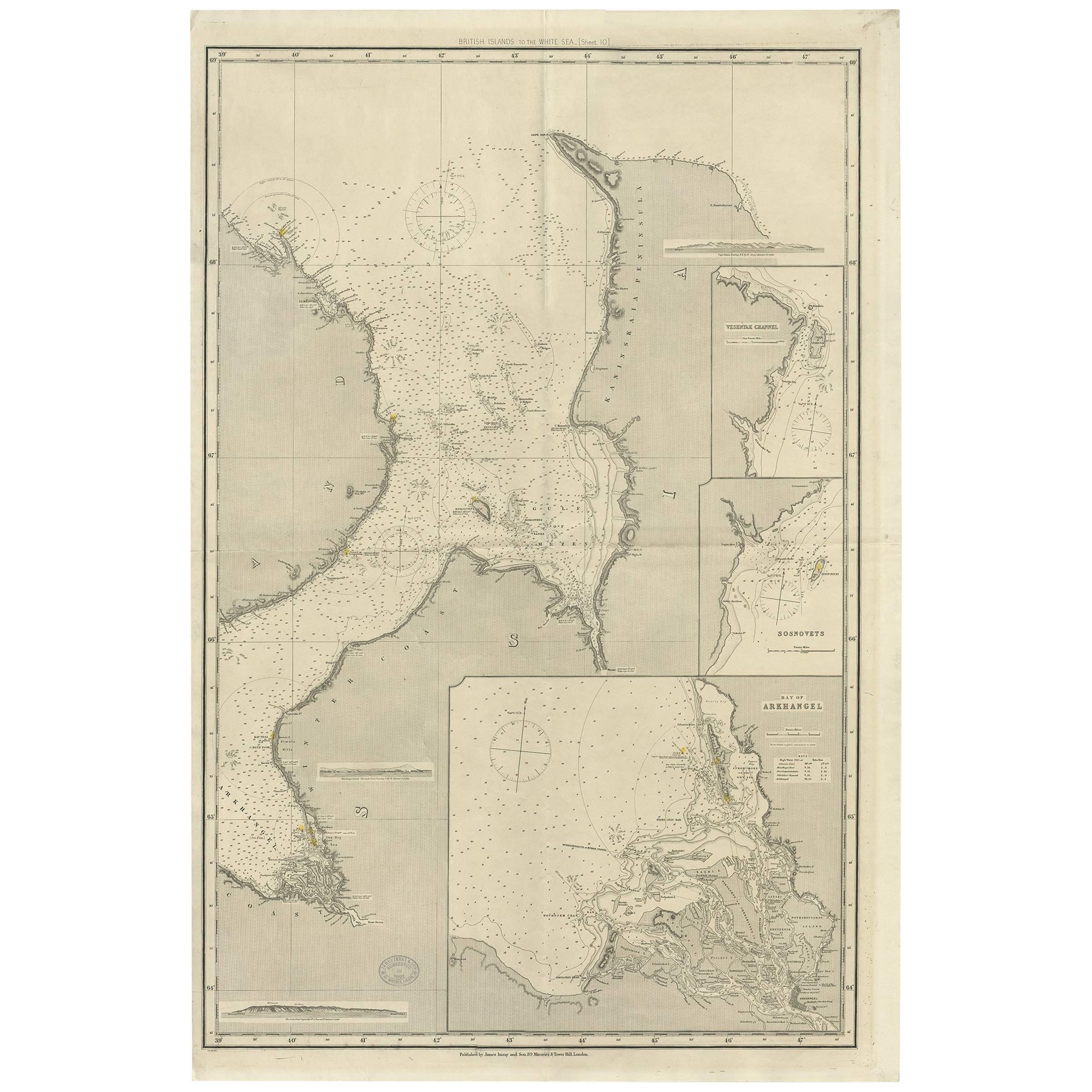
- Antique Map of the British Islands to the White Sea by J. ImrayLocated in Langweer, NLAntique large nautical chart of the British Islands to the White Sea. With insets of Veshnyak Channel, Sosnovets and the Bay of Arkhangel. Published by James Irmay and Son, circa 1875.Category
Antique Late 19th Century Maps
MaterialsPaper
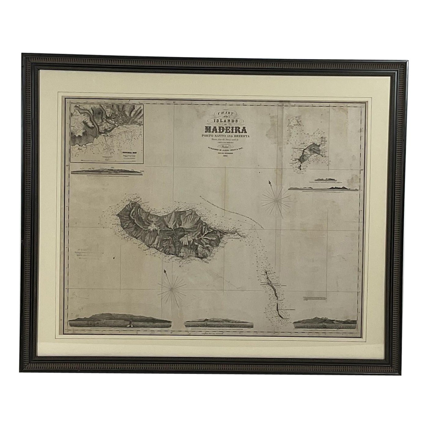
- 1865 Chart of the Islands of MadeiraLocated in Norwell, MARare James Imray chart from 1865 titled "Chart of the Islands of Madeira, Porto Santo and Dezerea" drawn from the survey made by Captain Ate Vidal Royal Navy, London. Published by Ja...Category
Antique 1860s European Maps
MaterialsPaper
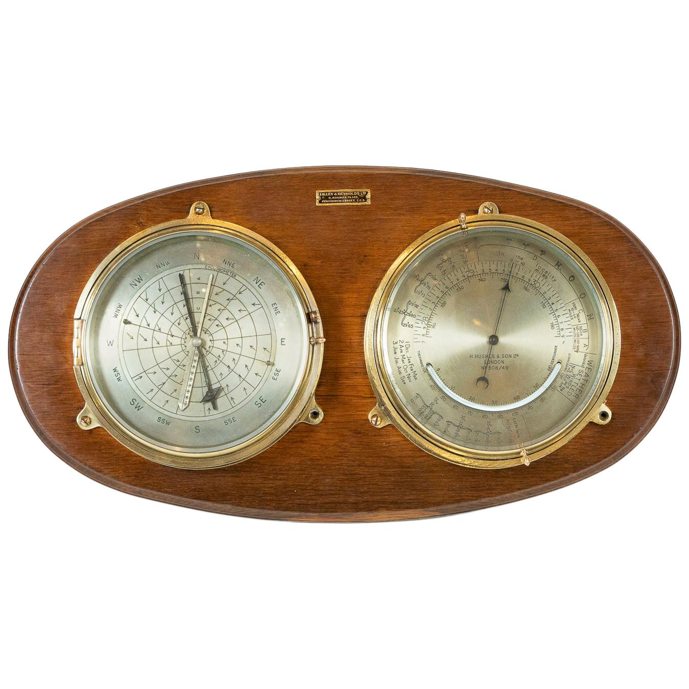
- Rare Barocyclonometer by Henry Hughes & Son of LondonBy Henry Hughes and Son Ltd.Located in London, GBA rare barocyclonometer by Henry Hughes & Son of London, circa 1920. Two silvered 7 inches dials mounted on an oval backboard, the left dial is the Northern hemisphere countercloc...Category
Early 20th Century English Scientific Instruments
MaterialsBrass
- Detailed Antique Map of the Windward Islands in the CaribbeanBy Covens & MortierLocated in Langweer, NLAntique map titled 'Carte des Antilles Francoises et des Isles Voisines'. Original antique map of the French Antilles, covering an area stretching from Guadeloupe in the north to Gre...Category
Antique Early 18th Century Maps
MaterialsPaper