Items Similar to Rare Hand-Colored Map of Lyonnais Region in France by Frederik De Wit c. 1688


Want more images or videos?
Request additional images or videos from the seller
1 of 6
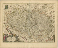
Rare Hand-Colored Map of Lyonnais Region in France by Frederik De Wit c. 1688
$766
£565.04
€640
CA$1,061.33
A$1,152.39
CHF 610.28
MX$14,125.04
NOK 7,552.41
SEK 7,136.63
DKK 4,872.23
About the Item
Title: Rare Hand-Colored Map of Lyonnais Region by Frederik De Wit c. 1688
Description: This beautifully detailed map, "Gouvernement General du Lyonnois," showcases the Lyonnais region in France as it appeared in the late 17th century. Published by Frederik De Wit around 1688, the map features original hand-coloring and intricate engravings that highlight towns, rivers, forests, and the region's topography. Its artistry is further enhanced by a richly adorned cartouche at the top right, complete with coats of arms, flags, and decorative elements that reflect the region’s historic significance.
The map is part of De Wit’s renowned collection, often assembled into composite atlases that included maps from leading Dutch cartographers like Hondius and Blaeu. These atlases were prized by scholars and collectors for their blend of geographic precision and aesthetic appeal. This map exemplifies De Wit’s exceptional craftsmanship, with his careful attention to detail and use of vivid colors bringing the landscape of Lyonnais to life.
Frederik De Wit, a key figure in the golden age of Dutch cartography, was celebrated for his town plans and atlases, which were widely admired for their elegance and clarity. His works are now highly sought after by collectors for their artistic and historical value.
Condition Report: The map is in very good condition, with minor age-related imperfections such as faint toning and light foxing. Original hand-coloring remains vibrant. Please refer to the image for additional details.
Framing and Matting Tips: To highlight the map’s historic and artistic features, choose a classic wood or gilded frame paired with acid-free, cream-toned matting. UV-protective glass is recommended to preserve the original hand-coloring. This piece is ideal for a gallery wall or study, where its detailed engraving and decorative cartouches can be appreciated up close.
- Dimensions:Height: 20.83 in (52.9 cm)Width: 24.41 in (62 cm)Depth: 0.01 in (0.2 mm)
- Materials and Techniques:Paper,Engraved
- Period:1680-1689
- Date of Manufacture:circa 1688
- Condition:Condition Report: The engraving is in good to very good condition, with some offsetting or color bleeding visible. Minor age-related imperfections. Centrefold as issued. Please examine the image carefully for additional details.
- Seller Location:Langweer, NL
- Reference Number:Seller: BG-14046-31stDibs: LU3054343438942
About the Seller
5.0
Recognized Seller
These prestigious sellers are industry leaders and represent the highest echelon for item quality and design.
Platinum Seller
Premium sellers with a 4.7+ rating and 24-hour response times
Established in 2009
1stDibs seller since 2017
2,622 sales on 1stDibs
Typical response time: <1 hour
- ShippingRetrieving quote...Shipping from: Langweer, Netherlands
- Return Policy
Authenticity Guarantee
In the unlikely event there’s an issue with an item’s authenticity, contact us within 1 year for a full refund. DetailsMoney-Back Guarantee
If your item is not as described, is damaged in transit, or does not arrive, contact us within 7 days for a full refund. Details24-Hour Cancellation
You have a 24-hour grace period in which to reconsider your purchase, with no questions asked.Vetted Professional Sellers
Our world-class sellers must adhere to strict standards for service and quality, maintaining the integrity of our listings.Price-Match Guarantee
If you find that a seller listed the same item for a lower price elsewhere, we’ll match it.Trusted Global Delivery
Our best-in-class carrier network provides specialized shipping options worldwide, including custom delivery.More From This Seller
View AllRare Hand-Colored Map of Lorraine and Barrois, France by Frederik De Wit c. 1688
Located in Langweer, NL
Title: Rare Hand-Colored Map of Lorraine and Barrois by Frederik De Wit c. 1688
Description: This remarkable 17th-century map, titled "Generalis Lotharingiae Ducatus," offers a deta...
Category
Antique 1680s Maps
Materials
Paper

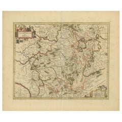
Rare Hand-Colored Map of Franche-Comté and Burgundy by Frederik De Wit c. 1688
Located in Langweer, NL
Title: Rare Hand-Colored Map of Franche-Comté and Burgundy by Frederik De Wit c. 1688
Description: This stunning 17th-century map, titled "Comitatus Burgundiae vulgo La Franche Comt...
Category
Antique 1680s Maps
Materials
Paper
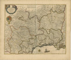
Stunning Hand-Colored Map of Languedoc in France by Frederik De Wit c. 1688
Located in Langweer, NL
Title: Stunning Hand-Colored Map of Languedoc by Frederik De Wit c. 1688
Description: This elegant 17th-century map, "Gouvernement General de Languedoc," beautifully illustrates the...
Category
Antique 1680s Maps
Materials
Paper
Hand-Colored 17th-Century Map of Orléanais in France by Frederik De Wit c. 1688
Located in Langweer, NL
Title: Hand-Colored 17th-Century Map of Orléanais by Frederik De Wit c. 1688
Description: This beautifully crafted map, "Gouvernement General du Pays Orléanois," illustrates the Orl...
Category
Antique 1680s Maps
Materials
Paper

Rare Hand-Colored Map of Champagne and Brie, France, by Frederik De Wit c. 1688
Located in Langweer, NL
Title: Rare Hand-Colored Map of Champagne and Brie by Frederik De Wit c. 1688
Description: This exquisite 17th-century map, "Champagne et Brie," beau...
Category
Antique 1680s Maps
Materials
Paper
Rare 17th-Century Map of Dauphiné in Southeastern France by F. De Wit, ca.1688
Located in Langweer, NL
Title: Rare Hand-Colored 17th-Century Map of Dauphiné by Frederik De Wit c. 1688
Description: This captivating 17th-century map of Dauphiné, titled "Nova et Accurata Delphinatus Vul...
Category
Antique 1680s Maps
Materials
Paper

You May Also Like
West Germany: Original Hand Colored 17th Century Map by Johannes Janssonius
By Johannes Janssonius
Located in Alamo, CA
An original hand colored copperplate engraved map entitled in Latin "Archiepiscopatus Maghdeburgensis et Anhaltinus Ducatus cum terris adjacentibus", published in Amsterdam in 1640 i...
Category
Mid-17th Century Old Masters More Prints
Materials
Engraving

Map of Oxfordshire coloured 18th century engraving by Thomas Kitchin
By Thomas Kitchin
Located in London, GB
To see our other original maps, scroll down to "More from this Seller" and below it click on "See all from this Seller" - or send us a message if you cannot find the poster you want....
Category
1760s Landscape Prints
Materials
Engraving

The Loire Valley of France: A 17th C. Hand-colored Map by Sanson and Jaillot
By Nicholas Sanson d'Abbeville
Located in Alamo, CA
This large 17th century copper plate hand-colored engraved map entitled "Gouvernement D'Orleans et la Generalite divisee en ses Elections Par...
Category
1690s Landscape Prints
Materials
Engraving

1640 Joan Bleau Map Entitled"Diocecese de rheims et le pais de rethel, " Eic.a011
Located in Norton, MA
1640 Joan Bleau map entitled
"Diocecese de rheims et le pais de rethel,"
Ric.a011
OAN BLAEU
Diocecese de Rheims, et le pais de Rethel.
Handcolored engraving, c.1640.
...
Category
Antique 17th Century Dutch Maps
Materials
Paper

L'Isle de France: A Hand-colored 17th Century Map by De Wit
By Frederick de Wit
Located in Alamo, CA
This colorful and detailed 17th century hand-colored copperplate map by Frederick De Wit was published in Amsterdam between 1666 and 1760. The map depicts the Île-de-France, which is one of the ancient provinces of France. Paris is located in the center of the map, with Versailles to the southwest The map extends from Rouen in the west to Reims in the east. The area around Paris, the Véxin Français, was the original domain of the king of France. Other areas were ruled by French feudal lords. For example, the Véxin Normand area was the domain of the Duke of Normandy...
Category
Early 18th Century Old Masters More Prints
Materials
Engraving

1640 Willem Blaeu Map Entitled "Contado di molise et principato vltra, " Ric.a003
By Willem Blaeu
Located in Norton, MA
1640 Willem Blaeu map entitled
"Contado di molise et principato vltra,"
Colored
Ric. a003
Measures: 38 x 49.6 cm and wide margins
DBLAEU.
Cou...
Category
Antique 17th Century Dutch Maps
Materials
Paper

More Ways To Browse
17th Century Dutch Wood Frames
Green Persian Rug
50 X 50 Coffee Table
Spanish Baroque Furniture
Couch Console
Vintage Burn
Sterling Silver Flatware Service For 12
Antique Dining Tables With Leaves
Decorative Wall Panels
Frank Lloyd Wright For Cassina
Natural Curved
Spanish Wool Rug
Leather Pouf And Ottomans
Low Side Tables
Set Of Four Italian Dining Chairs
Silk Runner Carpet
18th Century Blue And White Porcelain
3x5 Rugs