Items Similar to Sebastian Münster's 16th Century Map of the British Isles, ca.1590

Want more images or videos?
Request additional images or videos from the seller
1 of 6
Sebastian Münster's 16th Century Map of the British Isles, ca.1590
$607.03
$758.7820% Off
£454.29
£567.8720% Off
€512
€64020% Off
CA$837.44
CA$1,046.8020% Off
A$931.27
A$1,164.0920% Off
CHF 489.12
CHF 611.4120% Off
MX$11,385.74
MX$14,232.1720% Off
NOK 6,094.96
NOK 7,618.7020% Off
SEK 5,745.90
SEK 7,182.3720% Off
DKK 3,897.60
DKK 4,87220% Off
About the Item
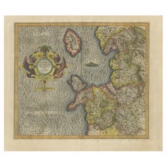
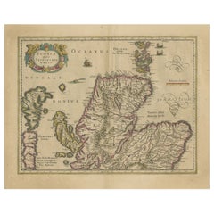
GREAT BRITAIN -- "ENGELLANDT mit dem anstossenden Reich Schottlandt so vorzeiten Albion und Britannia haben geheissen". (Basel, c. 1590).
Partly handcolored woodcut double-page map from S. Munster's 'Cosmographey'. 330 x 408 mm. (Lower margin cut short (touching the line), tiny hole in upper margin, sl. foxed/browned, lower right corner a bit thumbed).
Sebastian Münster's 16th Century Map of the British Isles from 'Cosmographia Universalis'
This map is a historical representation of the British Isles, including England, Scotland, and parts of Ireland and France. The map is from a early German atlas by Munster.
Here are some specific details about the map:
1. **Title and Orientation**:
- The title, written in German at the top, translates to "England along with the adjoining Kingdom of Scotland, which was formerly called Albion and Britannia."
- The map has compass directions labeled as "OCCIDENS" (West), "MERIDIES" (South), "OR IENS" (East), and "SEPTEN" (North).
2. **Geographic Features**:
- The map displays the British Isles, including parts of England, Scotland, and Ireland, as well as parts of France.
- Water bodies such as "Mare Hibernicum" (Irish Sea) and "Oceanus Germanicus" (German Ocean, now the North Sea) are labeled.
- Coastal features, cities, and towns are detailed, with many historical names that might differ from modern ones.
3. **Decorative Elements**:
- The map includes several artistic details such as sea monsters, ships, and ornate cartouches.
- A decorative compass rose can be seen, aiding in navigation.
4. **Regions and Cities**:
- Various regions and cities are labeled with their German names or Latinized forms, such as "Anglia" (England), "Scotia" (Scotland), and "Hibernia" (Ireland).
- Prominent cities like London ("Londin"), Edinburgh, and Dublin are marked.
5. **Scale and Insets**:
- The map includes a mileage scale in the bottom right corner, labeled "Milien Anglia" (English Miles).
- There is a descriptive text box in German in the bottom right corner, which provides additional context or information about the map's creation and purpose.
Overall, this map serves as an informative and decorative representation of the British Isles as understood in the German-speaking world during the time of its creation.
This map is part of a historical atlas created by the German cartographer Sebastian Münster. Here are the specific details:
1. **Maker**: Sebastian Münster
2. **Publisher**: The map was published by Sebastian Münster himself. He was known for his significant contributions to cartography and geography.
3. **Work**: The map is from Münster's famous work, "Cosmographia," which is one of the most popular and influential books of the 16th century. The full title is "Cosmographia Universalis."
4. **Publication Date**: The first edition of "Cosmographia" was published in 1544, and it underwent numerous editions. The map here offered would likely be from one of the editions published between 1544 and the late 16th century.
Sebastian Münster's "Cosmographia" was a comprehensive description of the world and included numerous maps and illustrations, making it a significant resource for geographical knowledge during the Renaissance period.
- Dimensions:Height: 13 in (33 cm)Width: 16.07 in (40.8 cm)Depth: 0 in (0.02 mm)
- Materials and Techniques:
- Period:
- Date of Manufacture:circa 1590
- Condition:Repaired: A few remains of tape on the reverse from an earlier mounting. Wear consistent with age and use. Condition: Good, given age. Lower margin cut short (touching the line), tiny hole in upper margin, slightly foxed/browned, lower right corner a bit thumbed. General age-related toning. Study the images carefully.
- Seller Location:Langweer, NL
- Reference Number:Seller: BG-137431stDibs: LU3054340299262
About the Seller
5.0
Recognized Seller
These prestigious sellers are industry leaders and represent the highest echelon for item quality and design.
Platinum Seller
Premium sellers with a 4.7+ rating and 24-hour response times
Established in 2009
1stDibs seller since 2017
2,609 sales on 1stDibs
Typical response time: <1 hour
- ShippingRetrieving quote...Shipping from: Langweer, Netherlands
- Return Policy
Authenticity Guarantee
In the unlikely event there’s an issue with an item’s authenticity, contact us within 1 year for a full refund. DetailsMoney-Back Guarantee
If your item is not as described, is damaged in transit, or does not arrive, contact us within 7 days for a full refund. Details24-Hour Cancellation
You have a 24-hour grace period in which to reconsider your purchase, with no questions asked.Vetted Professional Sellers
Our world-class sellers must adhere to strict standards for service and quality, maintaining the integrity of our listings.Price-Match Guarantee
If you find that a seller listed the same item for a lower price elsewhere, we’ll match it.Trusted Global Delivery
Our best-in-class carrier network provides specialized shipping options worldwide, including custom delivery.More From This Seller
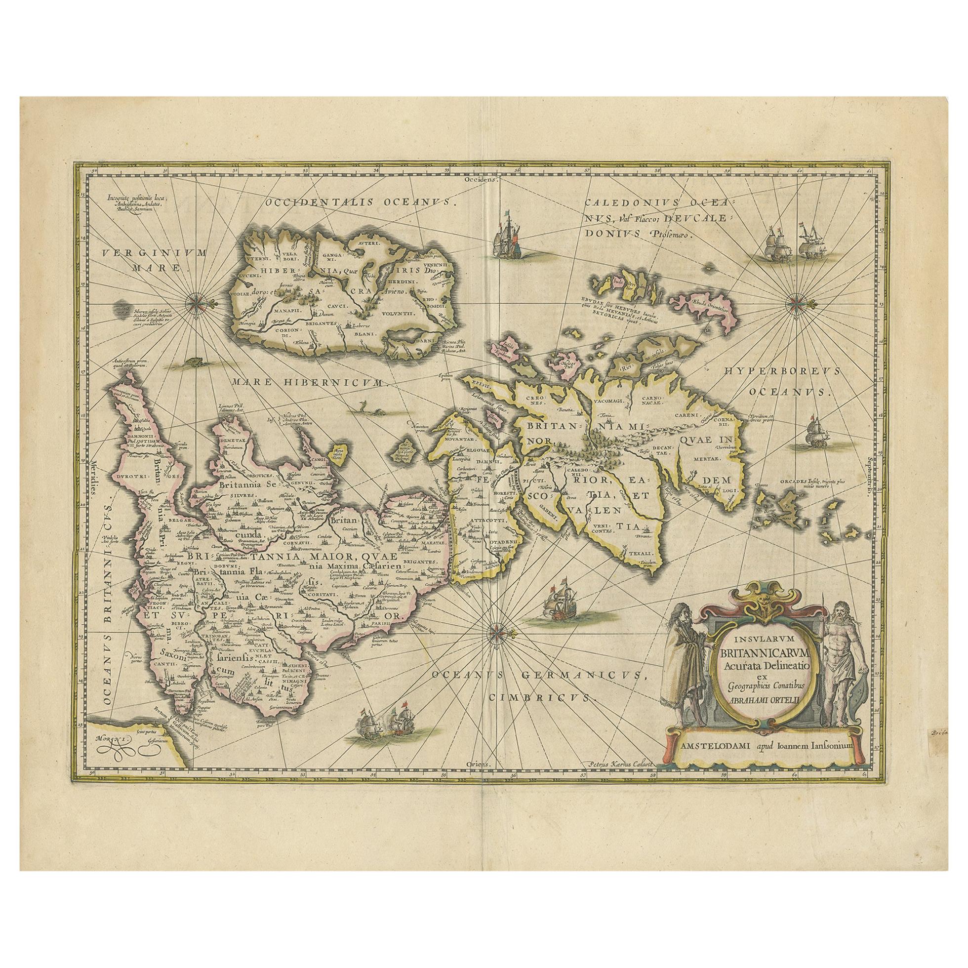
View AllAntique Map of the Ancient British Isles by Janssonius 'circa 1640'
Located in Langweer, NL
Antique map titled 'Insularum Britannicarum Acurata Delineatio'. Original antique map of the ancient British Isles. England and Wales are labelled as B...
Category
Antique Mid-17th Century Maps
Materials
Paper

$901 Sale Price
20% Off
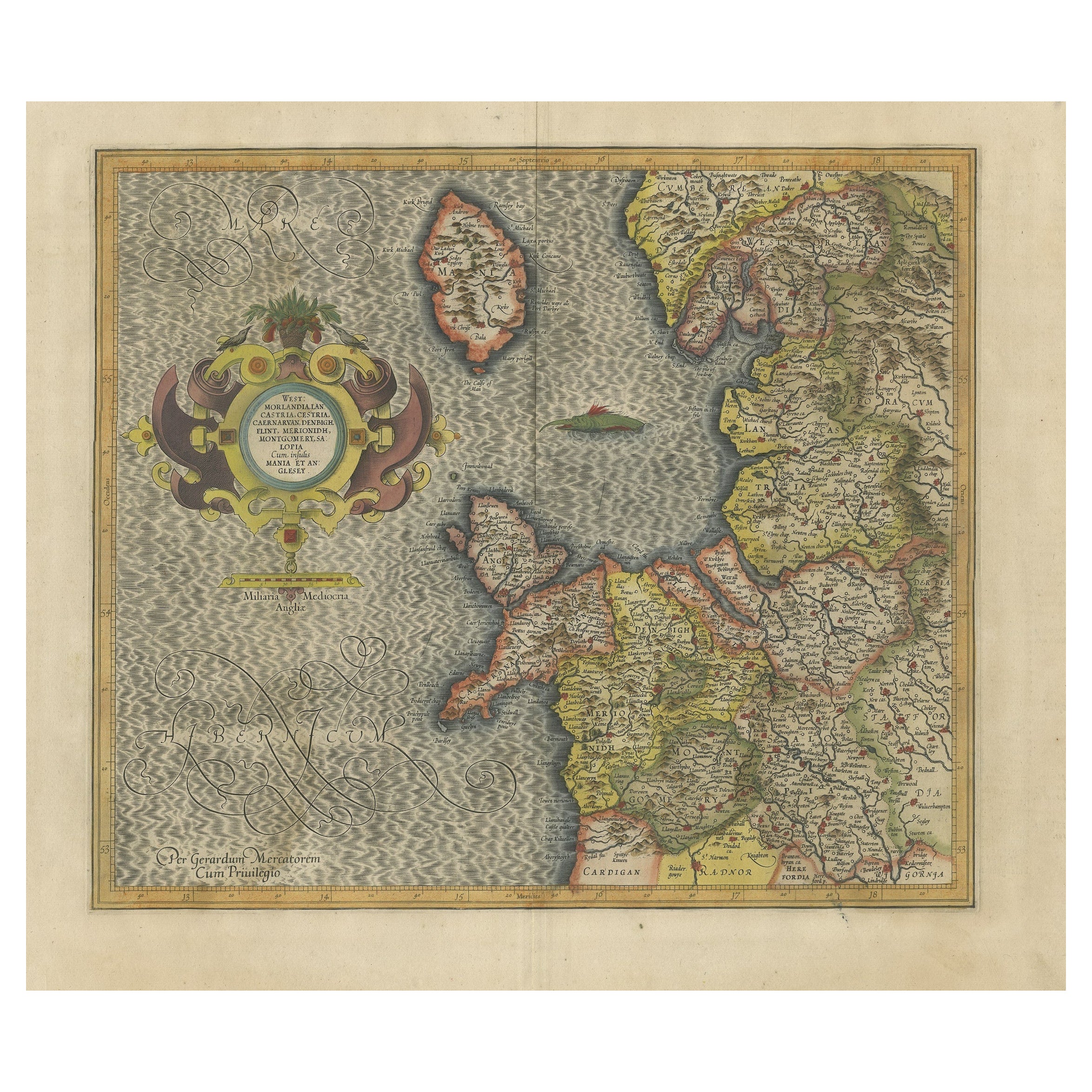
Antique Map of England by Mercator/Hondius, circa 1600
Located in Langweer, NL
Antique map titled 'Westmorlandia, Lancastria, Caernvan, Denbigh, Flint, Merionidh, Dalopia cum issulis Mania et Anglesey'. Original antique map of England...
Category
Antique 16th Century Maps
Materials
Paper
$901 Sale Price
20% Off
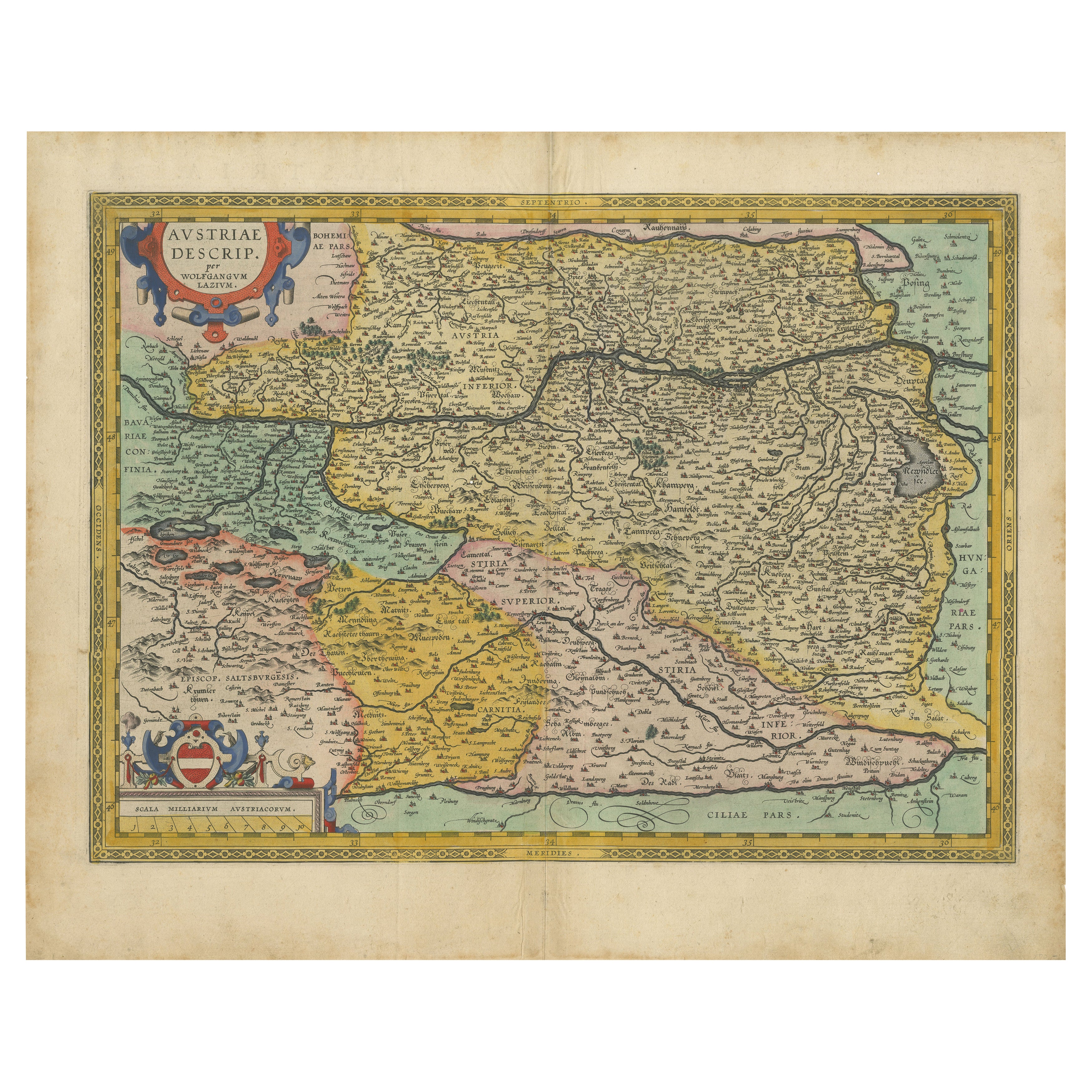
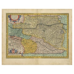
Austria by Wolfgang Lazius – A Magnificent 16th-Century Map from Ortelius
Located in Langweer, NL
Title:
Avstriae Descrip – Wolfgang Lazius’ Map of Austria, 16th Century
Description:
This extraordinary map of Austria pays homage to the Austrian humanist and cartographer Wo...
Category
Antique 16th Century Maps
Materials
Paper
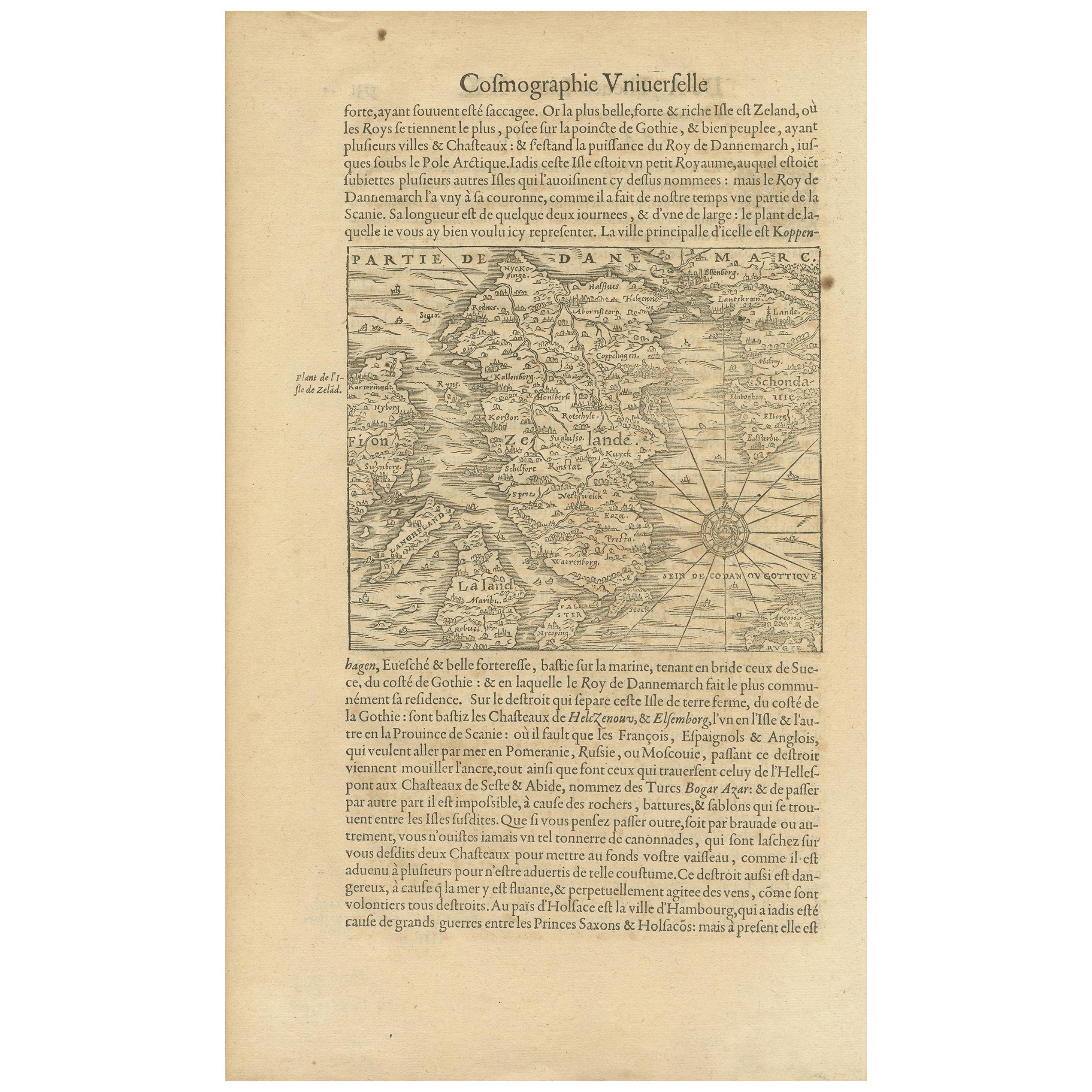
Antique Map of the Island of Zealand 'Denmark' by Thevet, circa 1590
Located in Langweer, NL
Antique map titled 'Partie de Danemarc'. Map of the island of Zealand, Denmark, including the city of Copenhagen. This map originates from 'Cosmographie Universelle' by André Thevet.
Category
Antique 16th Century Maps
Materials
Paper
$260 Sale Price
20% Off
Antique Map of the Northeast of England by Mercator 'circa 1620'
Located in Langweer, NL
Antique map titled 'Eboracum Lincolnia, Derbia, Staffordia, Notinghamia, Lecestria, Rutlandia, et Norfolcia'. Decorative early map of the northeast of England, comprising the countie...
Category
Antique Early 17th Century Maps
Materials
Paper

$521 Sale Price
20% Off
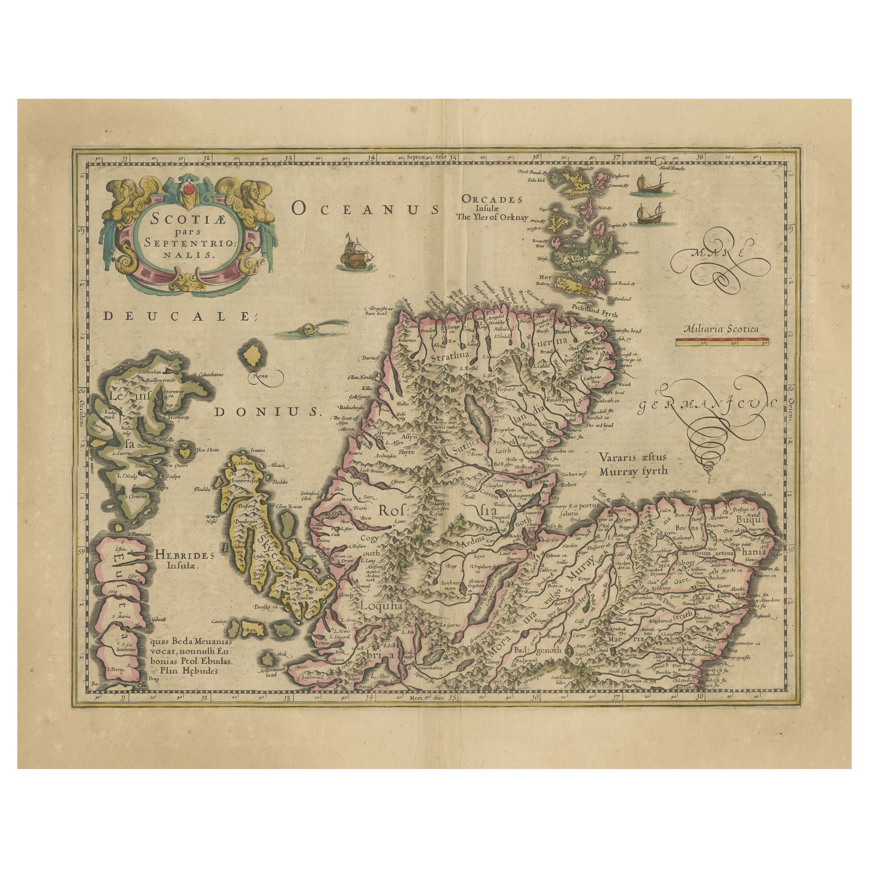
Original Antique Map of the Northern Part of Scotland, circa 1640
Located in Langweer, NL
The antique map, titled 'Scotiae pars septentrionalis,' depicts the northern part of Scotland. Crafted by Hondius around 1640, this map is a historical treasure showcasing the geogra...
Category
Antique Mid-17th Century Maps
Materials
Paper
$834 Sale Price
20% Off
You May Also Like
Rugen Island, Germany: An Early 17th Century Map by Mercator and Hondius
By Gerard Mercator
Located in Alamo, CA
This is an early 17th century map entitled "Nova Famigerabilis Insulae Ac Ducatus Rugiae Desciptio" (Map of Rugen Island, Germany) by Gerard Mercator and Henricus and Joducus Hondiu...
Category
Early 17th Century Old Masters Landscape Prints
Materials
Engraving

1646 Jansson Map Entitled "Procinvia Connactiae, " Ric.a006
Located in Norton, MA
1646 Jansson map entitled
"Procinvia connactiae,"
Ric.a006
Description: The PROVINCE of CONNAVGT 490 x 380From vol 4 of Jansson's Atlas Novus 1646, published in Amsterdam with...
Category
Antique 17th Century Unknown Maps
Materials
Paper

17th Century Map of Denmark by French Cartographer Sanson, Dated 1658
By Nicolas Sanson
Located in Copenhagen, K
17th century map of Denmark by French cartographer Sanson.
Nicolas Sanson (20 December 1600-7 July 1667) was a French cartographer, termed by some the creator of French geography an...
Category
Antique 17th Century French Maps
Materials
Paper

1592 Abraham Ortelius Map "Lorraine: Lotharingiae Nova Descripti, Ric.A005
Located in Norton, MA
1592 Abraham Ortelius map entitled
"Lorraine: Lotharingiae Nova Descripti
Ric.a005
Description: Ortelius is best known for producing the atlas from which this map comes from, "...
Category
Antique 16th Century Dutch Maps
Materials
Paper

Northern Scotland: 17th Century Hand-colored Map by Mercator
By Gerard Mercator
Located in Alamo, CA
This is a framed hand-colored 17th century map of Northern Scotland by Gerard Mercator entitled "Scotiae pars Septentrionalis", published in Amsterdam in 1636. It is a highly detailed map of the northern part of Scotland, with the northwest Highlands and the cities Inverness and Aberdeen, as well as the Orkney Islands and the Hebrides. There is a decorative title cartouche in the upper left corner.
The map is presented in an antiqued brown wood...
Category
Mid-17th Century Other Art Style Landscape Prints
Materials
Engraving

Framed 17th Century Map of Cumberland, England by John Speed, 1610
By John Speed
Located in Middleburg, VA
A fascinating and richly detailed antique map of Cumberland County in northwest England, drawn and published by the celebrated English cartographer John Spe...
Category
Antique Early 17th Century English British Colonial Maps
Materials
Copper, Gold Leaf

More Ways To Browse
16th Century England
16th Century Antiques
English 16th Century Furniture
16th France Renaissance
Sea Monster
English Watering Can
British Compass
Antique Compass London
Compass In A Box
Antique Box Compass
Cosmographia Universalis
Antique Oushak Carpets
Blue Coffee Tables
1945 Chair Juhl
Antique Three Leg Table
Folke Arstrom
Silver Over Copper
Vintage Barware Glasses