Items Similar to Two Sheet Map of the Principality of Wales Divided into Counties, 1804

Want more images or videos?
Request additional images or videos from the seller
1 of 5
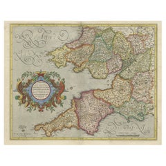
Two Sheet Map of the Principality of Wales Divided into Counties, 1804
$529.84per set
$662.30per set20% Off
£392.02per set
£490.02per set20% Off
€440per set
€550per set20% Off
CA$732.60per set
CA$915.75per set20% Off
A$804.30per set
A$1,005.38per set20% Off
CHF 419.61per set
CHF 524.51per set20% Off
MX$9,733.20per set
MX$12,166.50per set20% Off
NOK 5,259.13per set
NOK 6,573.91per set20% Off
SEK 4,955.48per set
SEK 6,194.35per set20% Off
DKK 3,350.17per set
DKK 4,187.72per set20% Off
About the Item
A well engraved and detailed large-scale map of Wales, printed on two sheets .
The map is thoroughly detailed and includes good information regarding the turnpike and mail roads as well as distances between market towns and also the canal network. Details shown include the canals, distances between market towns, "gentlemen's houses", and the sandbanks and hidden rocks in Cardigan Bay.
Original outline and wash colour defines the county's hundreds which are also listed in a numbered key.
The map first appeared in Smith's "New English Atlas Being A Complete Set of County Maps". Smith was a stationer and mapseller working in the Strand, London, from about 1800 onwards and continued the standard set by John Cary for precise, detailed maps, finely produced and without the embellishments of the previous century.
The maps from his county atlas set a new standard for their presentation and execution with the skilful fashion in which the wealth of cartographic detail has been compressed into the folio sheet. These maps justly met with great commercial success, being re-issued in atlas form and as folding maps into the 1860's.
With attractive colour the map has light, but negligible, centrefold discolouration.
- Dimensions:Height: 21.26 in (54 cm)Width: 25.2 in (64 cm)Depth: 0.02 in (0.5 mm)
- Sold As:Set of 2
- Materials and Techniques:Paper,Engraved
- Period:
- Date of Manufacture:1804
- Condition:Wear consistent with age and use. General age-related toning. Two small brown spots on the top sheet and light offset on the second, but overall a stunning set in original colors, perfectly fine for framing. Please study image carefully.
- Seller Location:Langweer, NL
- Reference Number:Seller: BG-12924-4 & 51stDibs: LU3054326992402
About the Seller
5.0
Recognized Seller
These prestigious sellers are industry leaders and represent the highest echelon for item quality and design.
Platinum Seller
Premium sellers with a 4.7+ rating and 24-hour response times
Established in 2009
1stDibs seller since 2017
2,641 sales on 1stDibs
Typical response time: <1 hour
- ShippingRetrieving quote...Shipping from: Langweer, Netherlands
- Return Policy
Authenticity Guarantee
In the unlikely event there’s an issue with an item’s authenticity, contact us within 1 year for a full refund. DetailsMoney-Back Guarantee
If your item is not as described, is damaged in transit, or does not arrive, contact us within 7 days for a full refund. Details24-Hour Cancellation
You have a 24-hour grace period in which to reconsider your purchase, with no questions asked.Vetted Professional Sellers
Our world-class sellers must adhere to strict standards for service and quality, maintaining the integrity of our listings.Price-Match Guarantee
If you find that a seller listed the same item for a lower price elsewhere, we’ll match it.Trusted Global Delivery
Our best-in-class carrier network provides specialized shipping options worldwide, including custom delivery.More From This Seller
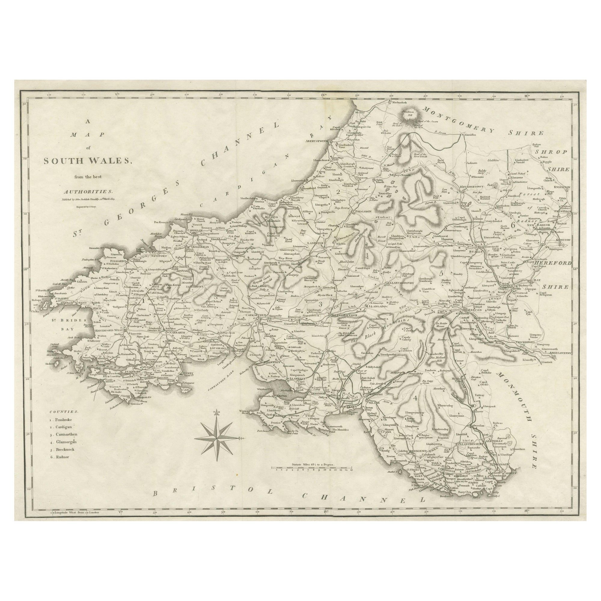
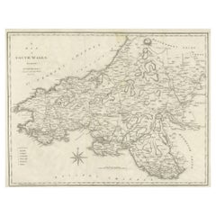
View AllLarge Antique County Map of South Wales, England
Located in Langweer, NL
Antique map titled 'A Map of South Wales from the best Authorities'. Original old county map of South Wales, England. Engraved by John Cary. Originates from 'New British Atlas' by Jo...
Category
Antique Early 19th Century Maps
Materials
Paper
$173 Sale Price
20% Off
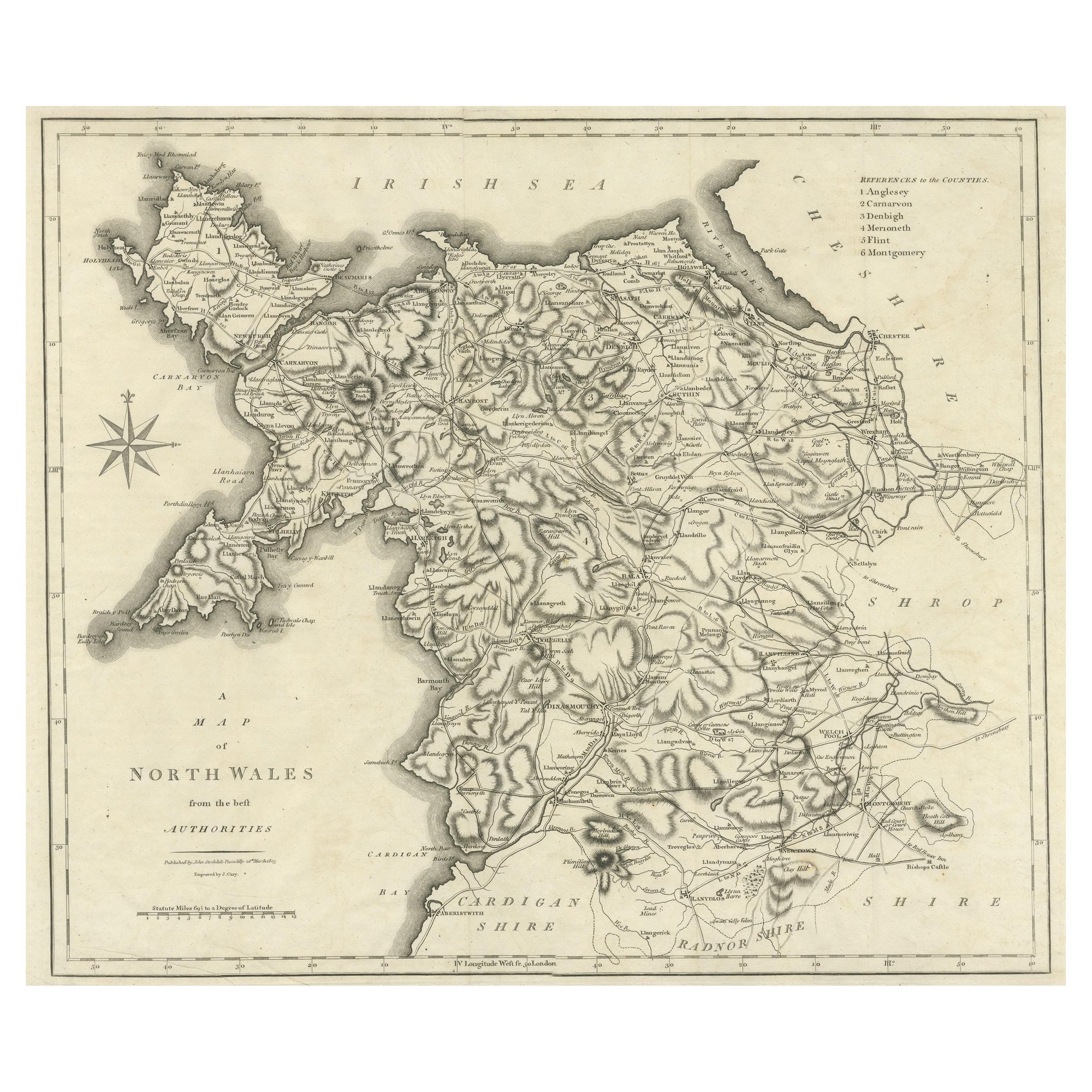
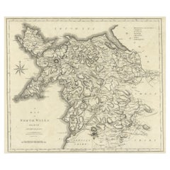
Large Antique County Map of North Wales, England
Located in Langweer, NL
Antique map titled 'A Map of North Wales from the best Authorities'. Original old county map of North Wales, England. Engraved by John Cary. Originates from 'New British Atlas' by Jo...
Category
Antique Early 19th Century Maps
Materials
Paper
$173 Sale Price
20% Off
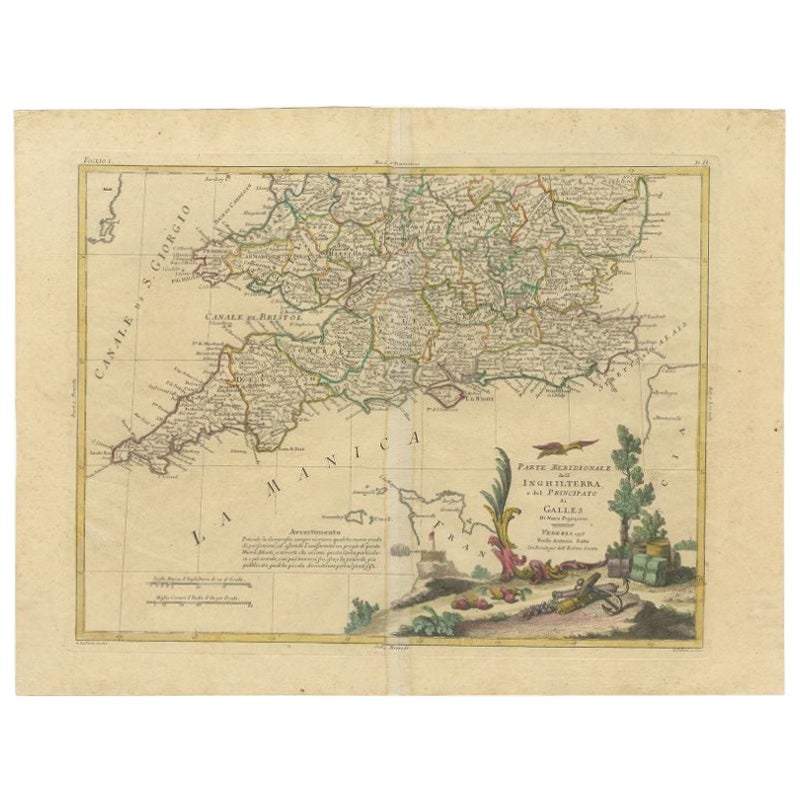
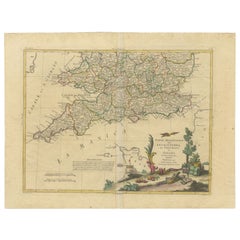
Antique Map of Southern England and Wales by Zatta, 1784
Located in Langweer, NL
"Antique map titled 'Parte Meridionale dell' Inghilterra e del Pricipato di Galles'. Engraved map of the southern part of England and Wales, with title cartouche. Shows political and...
Category
Antique 18th Century Maps
Materials
Paper
$205 Sale Price
20% Off
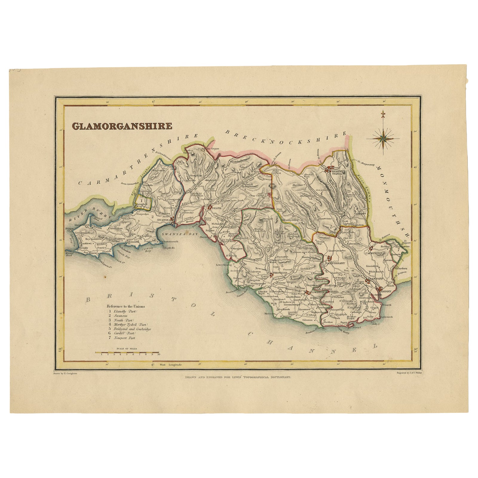
Old Map of Glamorganshire by Lewis 1844 – Swansea Cardiff Merthyr Tydfil Neath
Located in Langweer, NL
Title: Old Map of Glamorganshire by Samuel Lewis 1844 – Swansea Cardiff Merthyr Tydfil Neath
Description: This detailed map of Glamorganshire was published in 1844 for Samuel Lewis’ Topographical Dictionary of Wales. It showcases major towns such as Swansea, Cardiff, Merthyr Tydfil, Neath, and Bridgend. The map features original hand coloring that outlines the county borders and includes shaded topographical elements to show the landscape. A decorative compass rose and a reference to the seven unions add both style and historical context.
Condition:
The map is in good antique condition with minor age toning and clean margins. The engraving remains sharp and the original colors are clear and unfaded. No major damage or repairs are visible.
Framing suggestions:
Use a soft cream or ivory acid-free mat to match the natural tone of the paper. Choose a dark wood, antique gold, or black frame with a soft patina to enhance the historical feel. UV-protective glass is recommended to preserve the colors. This map is ideal for a home office, study, or as a thoughtful gift for those with Welsh heritage.
Keywords:
Glamorganshire map 1844 Samuel Lewis antique...
Category
Antique 1840s Maps
Materials
Paper

$231 Sale Price
20% Off
Antique Map of England & Wales by Wyld '1845'
Located in Langweer, NL
Antique map titled 'England & Wales'. Original antique map of England & Wales. This map originates from 'An Atlas of the World, Comprehending Se...
Category
Antique Mid-19th Century Maps
Materials
Paper

$136 Sale Price
24% Off
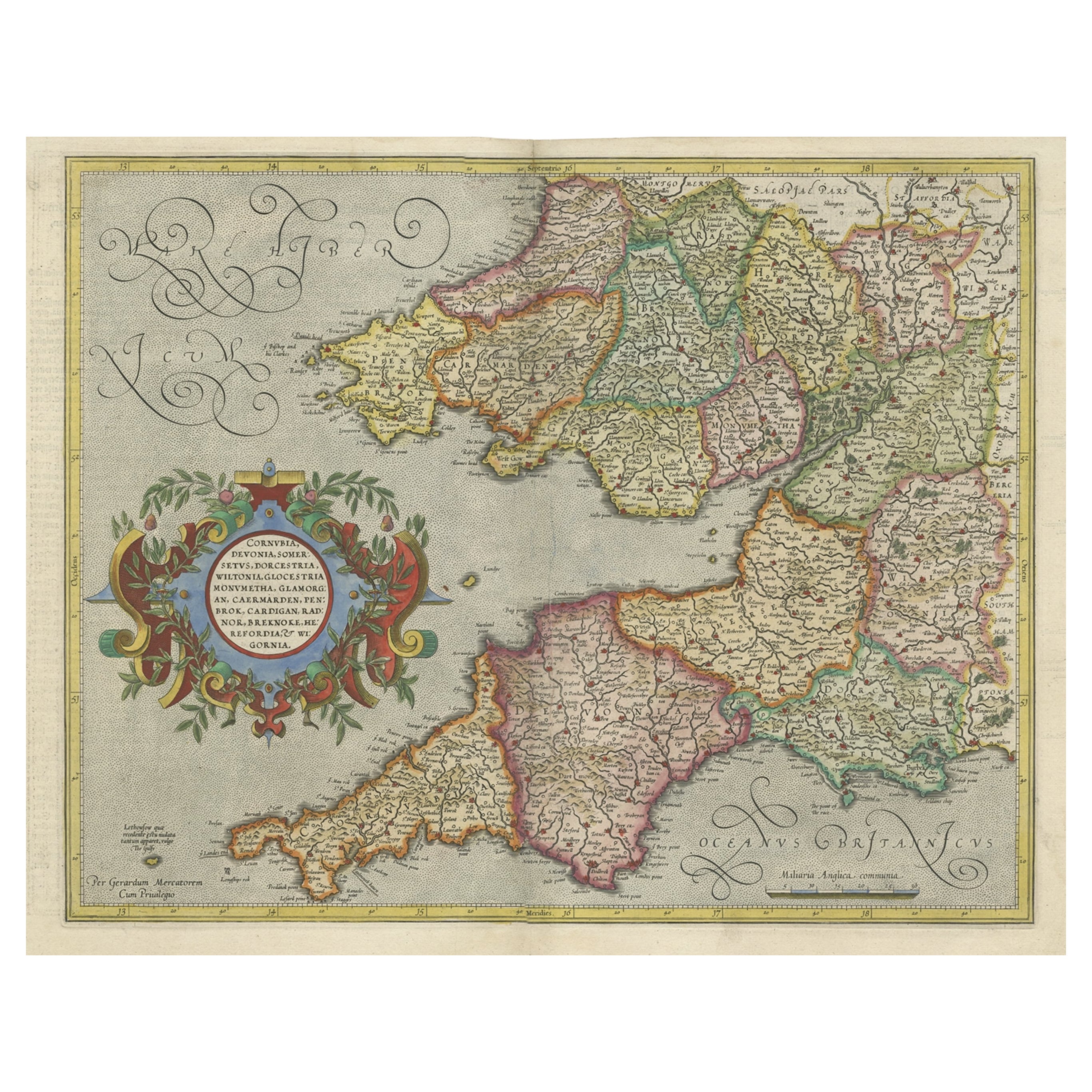
Original Antique Map of the English counties Cornwall, Devon, Dorset, etc, 1633
Located in Langweer, NL
Antique map titled 'Cornubia, Devonia, Somersetus, Dorcestria, Wiltonia, Glocestria, Monumetha, Glamorgan, Caermarden, Penbrok, Cardigan, Radnor, Breknoke et Herfordia'.
Old map of the English counties of Cornwall, Devon, Somerset, Dorset, Wiltshire, Gloucestershire, Herefordshire, Worcestershire etc. Originates from the 1633 German edition of the Mercator-Hondius Atlas Major, published by Henricus Hondius and Jan Jansson under the title: 'Atlas: das ist Abbildung der gantzen Welt, mit allen darin begriffenen Laendern und Provintzen: sonderlich von Teutschland, Franckreich, Niderland, Ost und West Indien: mit Beschreibung der selben.'
Artists and Engravers: Gerard Mercator (1512 - 1594) originally a student of philosophy was one of the most renowned cosmographers and geographers of the 16th century, as well as an accomplished scientific instrument maker. He is most famous for introducing Mercators Projection, a system which allowed navigators to plot the same constant compass bearing on a flat...
Category
Antique 1630s Maps
Materials
Paper
$1,107 Sale Price
20% Off
You May Also Like
Original Antique English County Map - Monmouthshire. J & C Walker. 1851
Located in St Annes, Lancashire
Great map of Monmouthshire
Original colour
By J & C Walker
Published by Longman, Rees, Orme, Brown & Co. 1851
Unframed.
Category
Antique 1850s English Other Maps
Materials
Paper

Original Antique English County Map, Herefordshire, J & C Walker, 1851
Located in St Annes, Lancashire
Great map of Herefordshire
Original colour
By J & C Walker
Published by Longman, Rees, Orme, Brown & Co. 1851
Unframed.
Category
Antique 1850s English Other Maps
Materials
Paper

Map North Wales Robert Marsden Anglesey
Located in BUNGAY, SUFFOLK
Map of North Wales by Robert Marsden
Including Anglesey
Charming topography and detail and colouring
just purchased more information to follow.
Category
Antique 18th Century English Georgian Maps
Materials
Paper

Antique Lithography Map, Monmouthshire, Framed, Welsh Cartography, Victorian
Located in Hele, Devon, GB
This is an antique lithography map of Monmouthshire. An English, framed atlas engraving of cartographic interest, dating to the mid 19th century and later.
Superb lithography of Mo...
Category
Antique Mid-19th Century British Victorian Maps
Materials
Glass, Wood, Paper
Old Horizontal Map of England
By Tasso
Located in Alessandria, Piemonte
ST/520 - Old rare Italian map of England, dated 1826-1827 - by Girolamo Tasso, editor in Venise, for the atlas of M.r Le-Sage.
Category
Antique Early 19th Century Italian Other Prints
Materials
Paper

Original Antique English County Map, Derbyshire, J & C Walker, 1851
Located in St Annes, Lancashire
Great map of Derbyshire
Original colour
By J & C Walker
Published by Longman, Rees, Orme, Brown & Co. 1851
Unframed.
Category
Antique 1850s English Other Maps
Materials
Paper

More Ways To Browse
Antique Florida Map
Antique Map Chile
Antique Map Of Georgia
Antique Mississippi Furniture
Burgundy Map
John Speed Antique Maps
Malabar Map
Malaysia Map
Map Of Syria
Taiwan Map
Antique Chicago Maps
Dutch Bible
New Jersey 19th Century
Thailand Map
Antique Coal Mining
Antique Dutch Bible
Antique Louisiana Map
Antique Maps Of Sicily