Items Similar to The World in the Assyrian Empire's Era: A Historical Map, Published in 1880

Want more images or videos?
Request additional images or videos from the seller
1 of 8
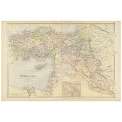
The World in the Assyrian Empire's Era: A Historical Map, Published in 1880
About the Item
This map from the "Spruner-Menke Atlas Antiquus" is titled "ORBIS TERRARVM regni Assyrii tempore," which translates to "The World at the Time of the Assyrian Kingdom." It depicts the known world during the era of the Assyrian Empire, which was one of the ancient Near East's most powerful states, dominating the region from approximately the 25th to the 7th centuries BC.
Here are some key aspects of the map:
1. **Scope of the Assyrian Empire**: The map likely outlines the extent of the Assyrian Empire at its peak, including detailed territories across the Middle East.
2. **Historical Geography**: It represents significant geographical features such as the Tigris and Euphrates rivers, the Mediterranean and Caspian Seas, and the mountain ranges of the region.
3. **Inset Maps**: The inclusion of inset maps, such as those detailing Egypt and Ethiopia, the pyramids, and the city of Nineveh, provide additional historical and archaeological context.
4. **Ancient Cities**: The map probably marks important cities, such as Nineveh, Ashur, and Babylon, which were significant in Assyrian history.
5. **Trade Routes**: It might also indicate trade routes that were crucial for the Assyrian economy, including those that connected the empire to distant lands.
6. **Latin Notations**: The use of Latin for place names and descriptions is consistent with the scholarly approach of the 19th century, when the atlas was produced.
7. **Cultural Detail**: Additional cultural and historical information might be provided in the notes and labels, giving insight into the Assyrian civilization and its interactions with neighboring cultures.
The map is a fascinating historical document for those interested in the Assyrian Empire and the broader ancient Near Eastern world, reflecting the knowledge and cartographic capabilities of the 19th century regarding ancient civilizations.
This map is from the "Spruner-Menke Atlas Antiquus," a historical atlas compiled by German cartographer Karl Spruner von Merz and later edited by Theodorus Menke. The atlas is known for its detailed maps of the ancient world, intended for educational and scholarly use, and was published in the late 19th century.
- Dimensions:Height: 15.56 in (39.5 cm)Width: 18.51 in (47 cm)Depth: 0 in (0.02 mm)
- Materials and Techniques:
- Period:
- Date of Manufacture:1880
- Condition:Good, given age. General age-related toning, especially around the edges. vertical folding line as issued. Please study scan carefully.
- Seller Location:Langweer, NL
- Reference Number:
About the Seller
5.0
Platinum Seller
These expertly vetted sellers are 1stDibs' most experienced sellers and are rated highest by our customers.
Established in 2009
1stDibs seller since 2017
1,916 sales on 1stDibs
Typical response time: <1 hour
- ShippingRetrieving quote...Ships From: Langweer, Netherlands
- Return PolicyA return for this item may be initiated within 14 days of delivery.
More From This SellerView All
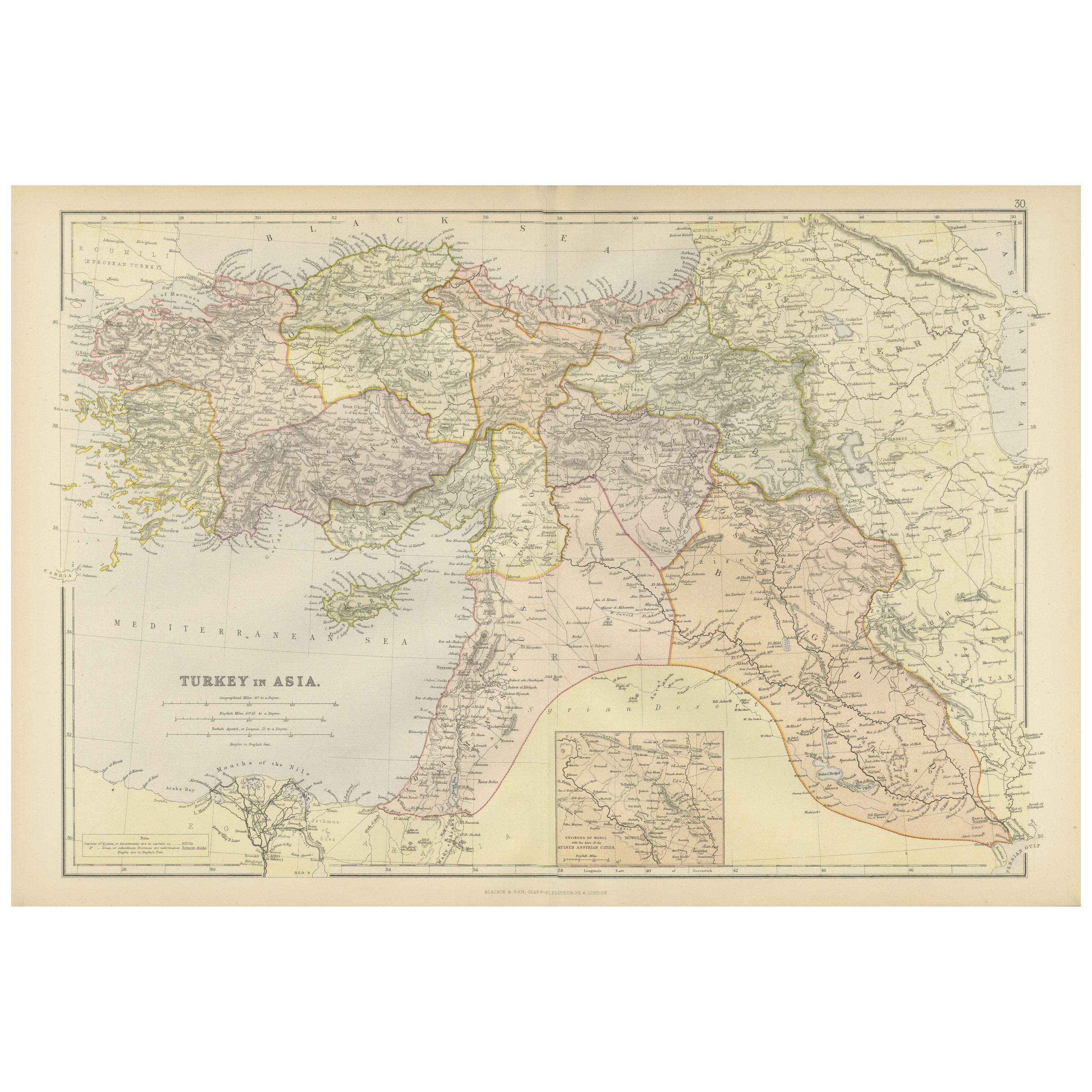
- Empire's Crossroads: An 1882 Map of Turkey in Asia by Blackie & SonLocated in Langweer, NLThis map, titled "Turkey in Asia," is another detailed illustration from the 1882 atlas by Blackie & Son. It showcases the vastness of the Asian territories of the Ottoman Empire, sp...Category
Antique 1880s Maps
MaterialsPaper
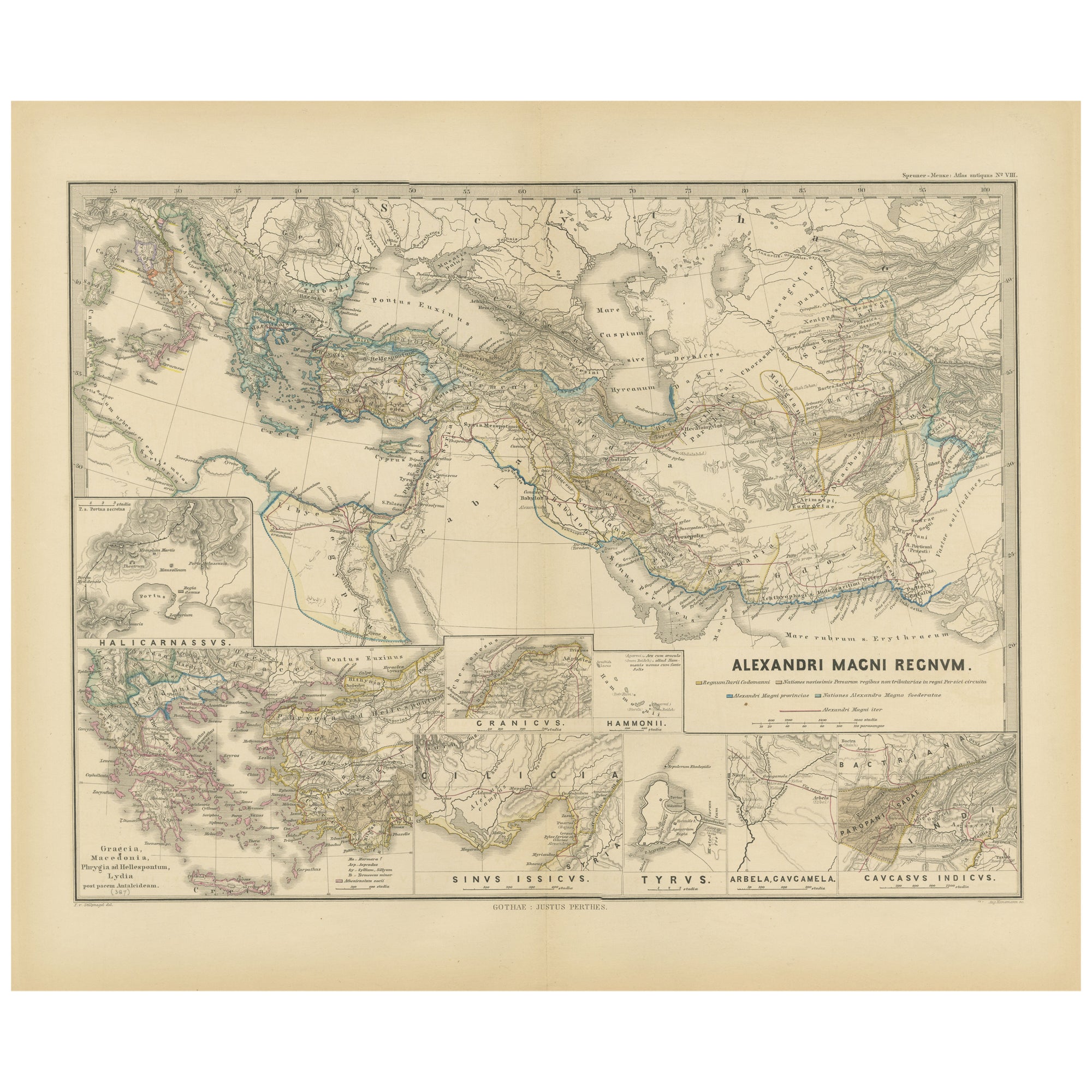
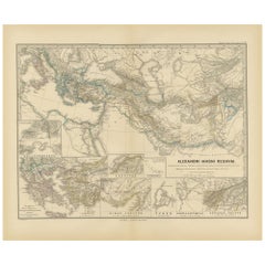
- Antique Map of The Kingdom of Alexander the Great, Published in 1880Located in Langweer, NLThe map is titled "ALEXANDRI MAGNI REGNUM," which translates to "The Kingdom of Alexander the Great." It depicts the vast territories conquered by Alexander the Great during his reig...Category
Antique 1880s Maps
MaterialsPaper
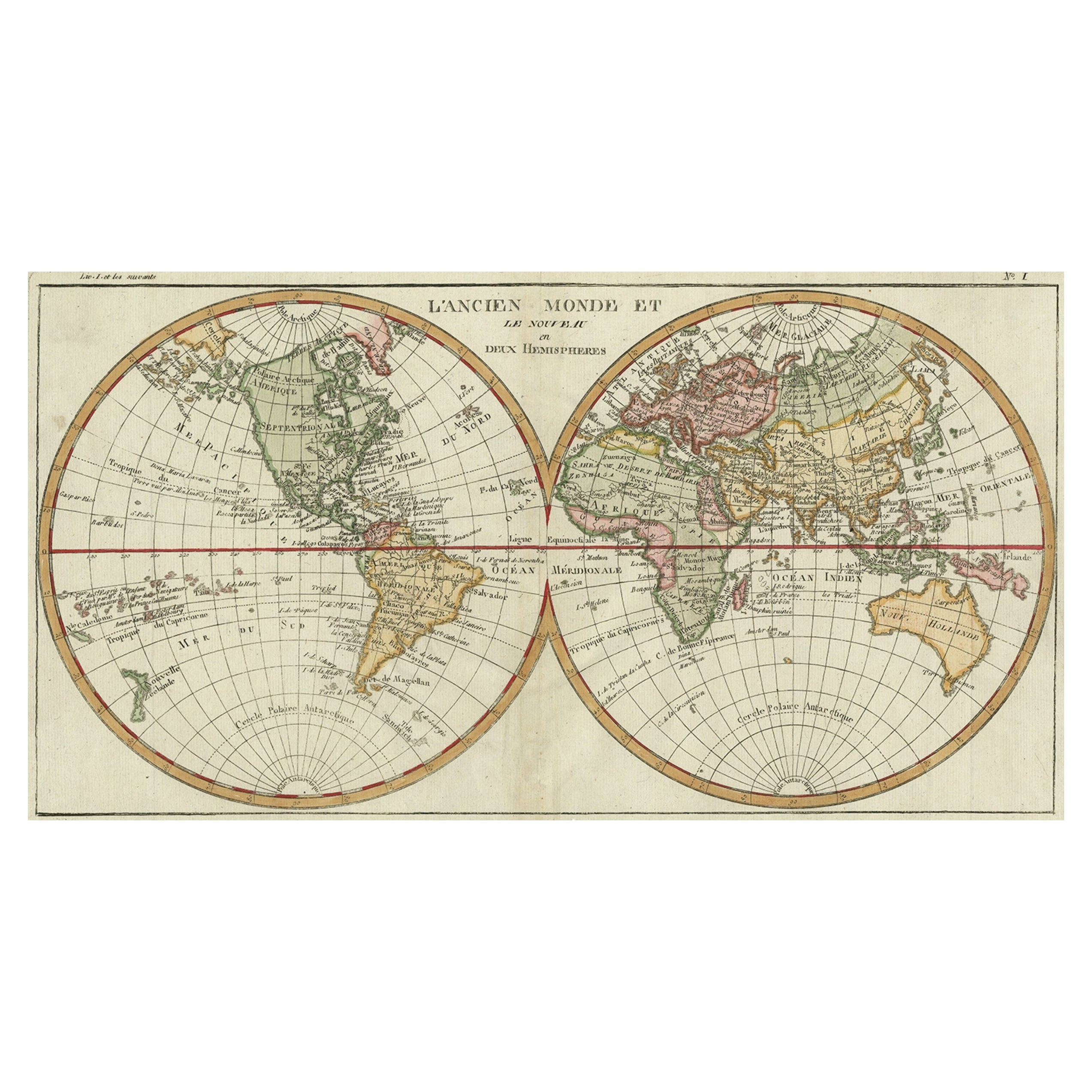
- Very Decorative Original Antique Map of the World, Published in France in c.1780By Rigobert BonneLocated in Langweer, NLAntique map titled 'L'Ancien Monde Et Le Nouveau en Deux Hemispheres' - Double hemisphere map of the World, showing the contemporary geographical...Category
Antique 18th Century Maps
MaterialsPaper
- Empire's Tapestry: Mapping Portugal's Global Legacy in 1903Located in Langweer, NLThis map is an original antique map that showcases Portuguese possessions around the turn of the 20th century, with a focus on Guinea-Bissau (referred to on the map as "Guiné Portugu...Category
Antique Early 1900s Maps
MaterialsPaper
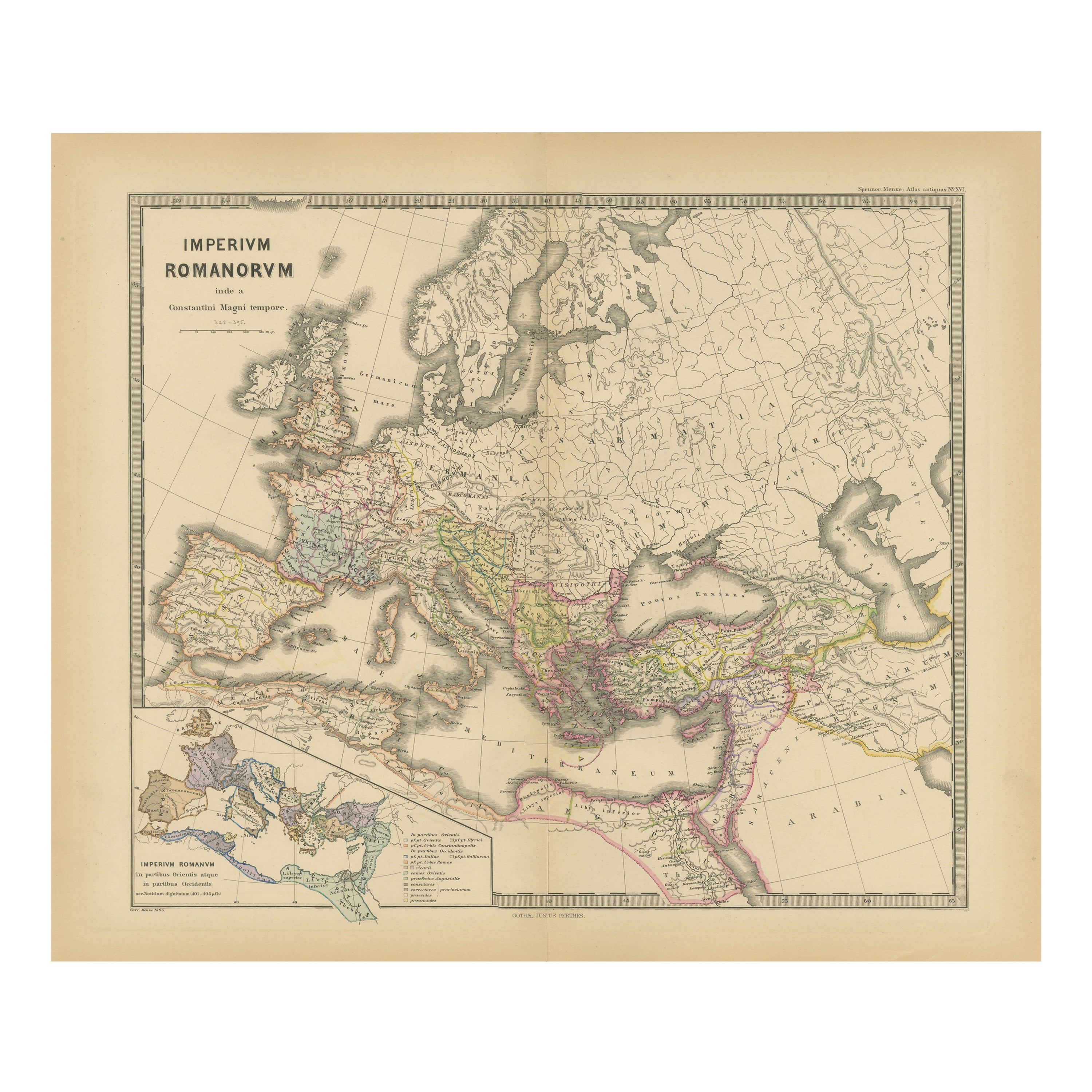
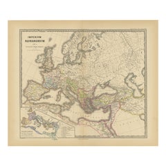
- The Roman Empire from the Time of Constantine the Great, Published in 1880Located in Langweer, NLAntique map titled: "IMPERIUM ROMANORUM inde a Constantini Magni tempore," which translates to "The Roman Empire from the time of Constantine the Great." This map is designed to re...Category
Antique 1880s Maps
MaterialsPaper
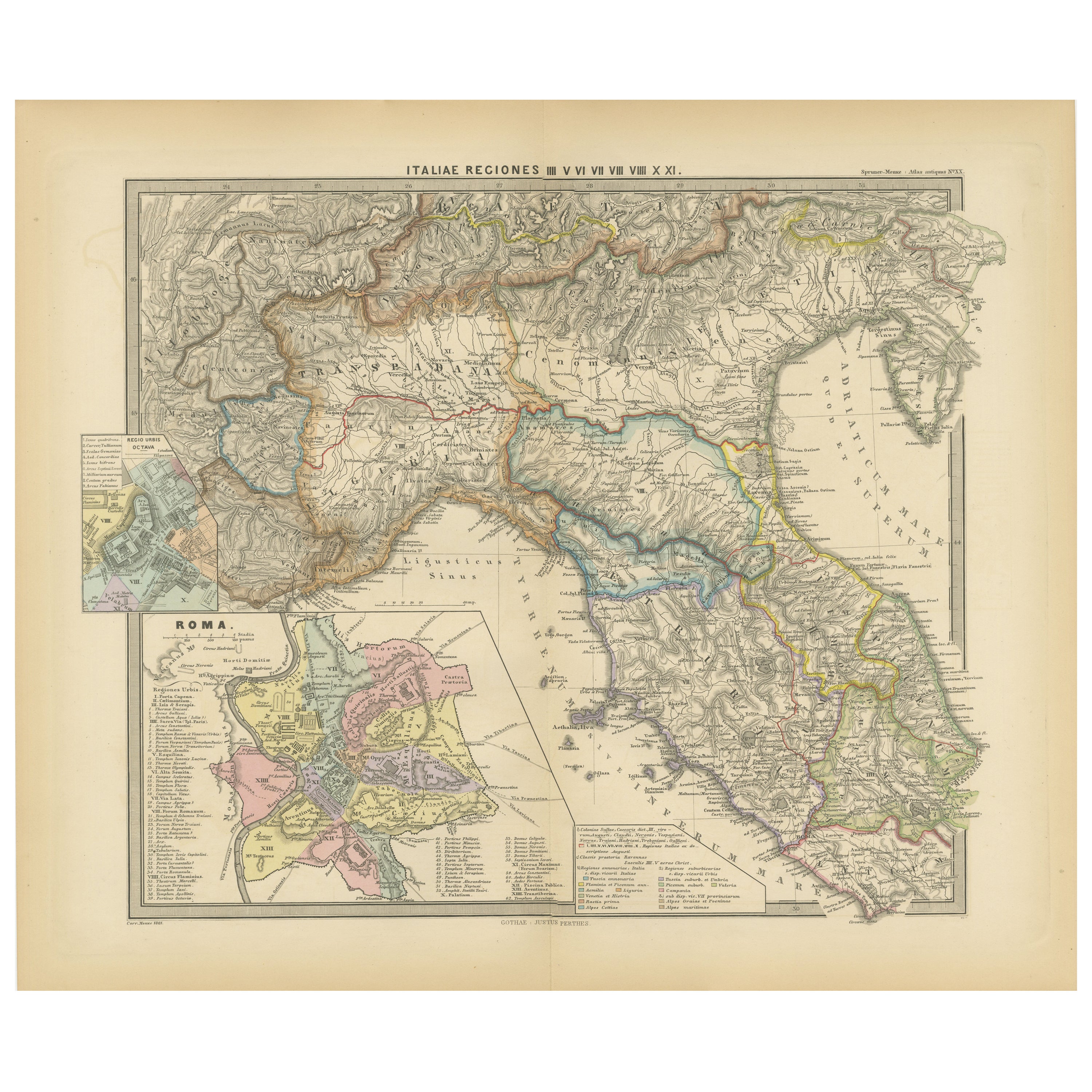
- Ancient Italy: Regions and Rome in the Roman Empire, Published in 1880Located in Langweer, NLThis print is an original detailed map titled "ITALIAE REGIONES I VII VIII IX XI," representing the regions of ancient Italy. Key Features of the Print: 1. **Regional Demarcations...Category
Antique 1880s Maps
MaterialsPaper


You May Also Like
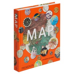
- Map, Exploring The WorldLocated in New York City, NY300 stunning maps from all periods and from all around the world, exploring and revealing what maps tell us about history and ourselves. Selected by an international panel of cartographers, academics, map dealers and collectors, the maps represent over 5,000 years of cartographic innovation drawing on a range of cultures and traditions. Comprehensive in scope, this book features all types of map from navigation and surveys to astronomical maps, satellite and digital maps, as well as works of art inspired by cartography. Unique curated sequence presents maps in thought-provoking juxtapositions for lively, stimulating reading. Features some of the most influential mapmakers and institutions in history, including Gerardus Mercator, Abraham Ortelius, Phyllis Pearson, Heinrich Berann...Category
21st Century and Contemporary Hong Kong Books
MaterialsPaper
- Map Exploring The World, Midi FormatLocated in New York City, NYA compelling exploration of the ways that humans have mapped the world throughout history - now in a compact new edition Map: Exploring the World brings together more than 250...Category
21st Century and Contemporary Books
MaterialsPaper
- Colored wall map of the WORLDBy ChambonLocated in ZWIJNDRECHT, NL“Mappe Monde, contenant les Parties Connues du Globe Terrestre” CHAMBON, Gobert-Denis (France, 17.. - 1781) Paris, Longchamps et Janvier, 1754 Size H. 115 x W. 145 cm. Gobert-Denis Chambon made copper engraving after the work of Guillaume De L’Isle, published in 1754 by Jean Janvier and S.G. Longschamps. A huge wall map of the world in two hemispheres printed on two sheets, depicting the Eastern and Western hemispheres supported by two male figures, decorated at the bottom right and left with two celestial hemispheres (boreal and southern) and at the bottom in the middle with an armillary sphere, in addition. This map is most notable for its depiction of the Sea of Japan labeled "Mer de Corée" and of "Mer de L'Ouest" or Sea of the West - a great sea, easily the size of the Mediterranean, to flow from the then-known Strait of Juan de Fuca...Category
Antique Mid-18th Century French French Provincial Maps
MaterialsWood, Paper

- World Relief MapLocated in Antwerp, BELarge world relief map. Measures: Width 232 cm. Height 158 cm.Category
Mid-20th Century German Mid-Century Modern Maps
MaterialsAcrylic
- The World of Rodin by William Harlan Hale, published in 1976 Hardcover BookBy Auguste RodinLocated in North Hollywood, CAThe World of Rodin by William Harlan Hale, published in 1976 by Time Life, USA. The World of Rodin 1840-1917 Hardcover With Slipcase Time Life Vintage Book. 192 pages, pictorial en...Category
20th Century American Folk Art Books
MaterialsPaper
- Antique Oarsman's Map of the River Thames, English, Cartography, Published 1912Located in Hele, Devon, GBThis is an antique copy of The Oarsman's and Angler's Map of the River Thames - New Edition. An English, bound map book, published in English by Edward Stanford, London, this new edi...Category
Early 20th Century British Other Books
MaterialsPaper