Want more images or videos?
Request additional images or videos from the seller
1 of 21
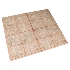
World Map Published in June 1783 by Stackhouse and Engraved by S.J. Neele London
$2,045.69List Price
About the Item
- Dimensions:Height: 21.26 in (54 cm)Width: 36.93 in (93.8 cm)Depth: 0.79 in (2 cm)
- Materials and Techniques:
- Place of Origin:
- Period:1780-1789
- Date of Manufacture:1783
- Condition:
- Seller Location:Milan, IT
- Reference Number:1stDibs: LU1020222485992
About the Seller
5.0
Vetted Professional Seller
Every seller passes strict standards for authenticity and reliability
Established in 1999
1stDibs seller since 2014
398 sales on 1stDibs
Typical response time: 2 hours
Authenticity Guarantee
In the unlikely event there’s an issue with an item’s authenticity, contact us within 1 year for a full refund. DetailsMoney-Back Guarantee
If your item is not as described, is damaged in transit, or does not arrive, contact us within 7 days for a full refund. Details24-Hour Cancellation
You have a 24-hour grace period in which to reconsider your purchase, with no questions asked.Vetted Professional Sellers
Our world-class sellers must adhere to strict standards for service and quality, maintaining the integrity of our listings.Price-Match Guarantee
If you find that a seller listed the same item for a lower price elsewhere, we’ll match it.Trusted Global Delivery
Our best-in-class carrier network provides specialized shipping options worldwide, including custom delivery.You May Also Like
Copper Engraved Grenada Map by John Thompson Published in 1810
Located in Langweer, NL
John Thomson's original antique map of Grenada, dating back to 1810 and hailing from Edinburgh, stands as a testament to meticulous cartography. This historical piece, adorned with o...
Category
Antique Early 19th Century Maps
Materials
Paper
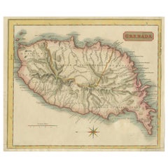
$231 Sale Price
20% Off
H 9.85 in W 11.62 in D 0.01 in
Antique Map of Polynesia and Australasia by Neele, 1825
Located in Langweer, NL
Antique map titled 'Polynesia and Australasia'. It shows Australia (New Holland), part of Asia, New Zealand and many islands. This map originates from 'Encyclopedia Londinensis'.
Category
Antique Early 19th Century Maps
Materials
Paper

$115 Sale Price
20% Off
H 8.67 in W 11.23 in D 0.02 in
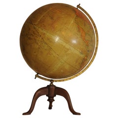
Antique World Globe From Fleet Street London 1923 on Wooden Stand
Located in Reading, Berkshire
Antique Terrestrial Geographia of Fleet Street London 12"inch World Globe on handcrafted Wooden Three Legged Base 1923
Made 55 Fleet Street, London
Beautiful desktop globe, showcas...
Category
Vintage 1920s British Art Deco Globes
Materials
Wood, Paper
Jerusalem and Temple Imaginary Map by Blome, Published London 1689
Located in Langweer, NL
Imaginary Plan of Jerusalem by Blome after Villalpando, 1689
This impressive antique engraving presents an imaginary plan of Jerusalem by Richard Blome, published in 1689. The engra...
Category
Antique Late 17th Century English Maps
Materials
Paper
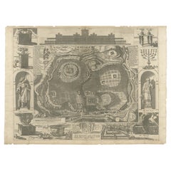
$649
H 16.74 in W 23.23 in D 0.01 in
1790 Thomas Stackhouse Map, Entitled "Russia in Europe, " , Ric.a004
Located in Norton, MA
1790 Thomas Stackhouse map, entitled
"Russia in Europe"
Ric.a004
Stackhouse, Thomas
Russia in Europe [map]
London: T. Stackhouse, 1783. Map. Matted hand-colored copper engraving. Image size: 14.5 x 15.25 inches. Mat size: 22.75 x 23.75 inches. A beautiful example of this map of Eastern Europe...
Category
Antique 17th Century Unknown Maps
Materials
Paper

$225
H 23.75 in W 22.75 in D 1 in
The World in the Assyrian Empire's Era: A Historical Map, Published in 1880
Located in Langweer, NL
This map from the "Spruner-Menke Atlas Antiquus" is titled "ORBIS TERRARVM regni Assyrii tempore," which translates to "The World at the Time of the Assyrian Kingdom." It depicts the...
Category
Antique 1880s Maps
Materials
Paper
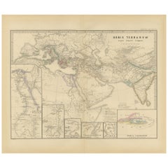
$356 Sale Price
20% Off
Free Shipping
H 15.56 in W 18.51 in D 0 in
World Map – Mercator Projection with Global Sea Routes, Published in 1857
Located in Langweer, NL
World Map – Mercator Projection with Global Sea Routes 1857
This attractive antique print shows a world map titled “Planiglob in Mercators Projection zur Übersicht der Erdfläche und...
Category
Antique Mid-19th Century German Maps
Materials
Paper

$457
H 14.77 in W 17.88 in D 0.01 in
Antique Folding London Map, English, Cartography, Historic, Georgian, Dated 1783
Located in Hele, Devon, GB
This is an antique folding London map. An English, paper on linen cartographical study of the London metropolis and the surrounding area, published in the mid Georgian period, dated ...
Category
Antique Late 18th Century British Georgian Maps
Materials
Linen, Paper
$1,004
H 6.3 in W 6.11 in D 0.6 in
Pocket Globe by Nathaniel Hill, London 1754
Located in Milano, IT
Nathaniel Hill
Pocket globe
London, 1754
The globe is contained in its original case, which itself is covered in shark skin.
There are slight gaps in the original paint on the sphere. The case no longer closes.
The sphere measures 2.6 in (6.8 cm) in diameter whereas the case measures 2.9 in (7.4 cm) in diameter.
lb 0.24 (kg 0.11)
The globe is made up of twelve printed paper gores aligned and glued to the sphere.
In the North Pacific Ocean there is a scroll with the inscription:
A
New
terrestrial
Globe
by
Nath. Hill,
1754.
The celestial globe is depicted on the inside of the box.
On the terrestrial globe much of central and southern Africa is empty. North America bears only the name of some British colonies. It shows California as a peninsula and the northwest coast of America as "unknown parts" (Alaska is not described and is only partially delineated; it would become part of the United States in 1867). The route of Admiral Anson is traced (1740) and the trade winds are indicated by arrows. Australia, still named New Holland (the new name would be introduced in 1829), is part of the west coast. (See Van der Krogt, P., Old Globes in the Netherlands, Utrecht 1984, p. 146 and Van der Krogt, P. - Dekker, E., Globes from the Western World, London 1993, p. 115.)
Nathaniel Hill (London, news from 1746 to 1768) had impeccable professional credentials: he had done his apprenticeship with Richard Cushee, who at the time was carrying out surveying work for John Senex's Surrey map...
Category
Antique 1750s English George II Globes
Materials
Shagreen, Paper
Very Decorative Original Antique Map of the World, Published in France in c.1780
By Rigobert Bonne
Located in Langweer, NL
Antique map titled 'L'Ancien Monde Et Le Nouveau en Deux Hemispheres' - Double hemisphere map of the World, showing the contemporary geographical...
Category
Antique 18th Century Maps
Materials
Paper

$741 Sale Price
20% Off
H 10.24 in W 17.6 in D 0 in
More From This Seller
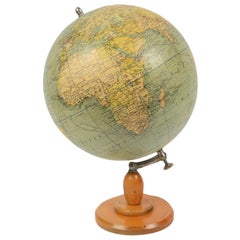
View AllAntique Terrestrial Globe Published in 1940s by Girard Barrère et Thomas, Paris
Located in Milan, IT
Terrestrial globe published in the 1940s by Girard Barrère et Thomas 17, Rue de Buci Paris. Turned wooden base, papier mâché sphere covered with paper printed by engraving on copper ...
Category
Vintage 1940s French Scientific Instruments
Materials
Wood, Paper
Old Map Depicting the Entire Earth's Surface Divided into Six Parts France 1850
Located in Milan, IT
Map depicting the entire earth's surface divided into six parts which depicts the position of peoples on Earth based on the assumption that it is impossible for each people to have t...
Category
Antique Mid-19th Century French Maps
Materials
Glass, Wood, Paper

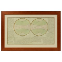
1850 Old French Map Depicting the Entire Earth's Surface Divided into Two Parts
Located in Milan, IT
Map depicting the entire earth's surface divided into two parts corresponding to the two hemispheres and showing the Arctic to Antarctic polar circle, the tropics of Cancer and Capri...
Category
Antique Mid-19th Century French Maps
Materials
Glass, Wood, Paper
1850 Old French Map Depicting the Entire Earth's Surface Divided into Two Parts
Located in Milan, IT
Geographical map depicting the entire earth's surface divided into two parts that correspond to the two hemispheres or globes, the map deals with the earth in general. Detailed expla...
Category
Antique Mid-19th Century French Maps
Materials
Glass, Wood, Paper

1850 Old French Map Depicting the Entire Earth's Surface Divided into Two Parts
Located in Milan, IT
Geographical map depicting the entire earth's surface divided into two parts that correspond to the two hemispheres where the emerged lands are depicted which have been classified wi...
Category
Antique Mid-19th Century French Maps
Materials
Glass, Wood, Paper

1850 Old French Map Depicting the Entire Earth's Surface Divided into Two Parts
Located in Milan, IT
Geographical map depicting the entire earth’s surface divided into two parts that correspond to the two hemispheres or globes, the map deals with the latitudes and longitudes, the me...
Category
Antique Mid-19th Century French Maps
Materials
Glass, Wood, Paper
