Rare Original 1852 Pictorial Map of the United States by Thayer Co.
View Similar Items


1 of 6
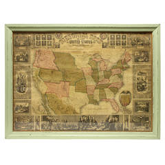
Rare Original 1852 Pictorial Map of the United States by Thayer Co.
About the Item
- Creator:Horace Thayer Co. 1 (Maker)
- Dimensions:Height: 32.5 in (82.55 cm)Width: 43.5 in (110.49 cm)Depth: 1 in (2.54 cm)
- Materials and Techniques:
- Place of Origin:
- Period:
- Date of Manufacture:1852
- Condition:Wear consistent with age and use.
- Seller Location:Chicago, IL
- Reference Number:1stDibs: LU92471919552
You May Also Like
- Antique Map of the United States by Lowry, '1852'Located in Langweer, NLAntique map titled 'United States'. Four individual sheets of the United States. This map originates from 'Lowry's Table Atlas constructed and engraved from the most recent Authoriti...Category
Antique Mid-19th Century Maps
MaterialsPaper
- Old Decorative Pictorial Map of the United States, circa 1953Located in Langweer, NLAntique map titled 'A Pictorial Map of the United States of America Showing Principal Regional Resources, Products, and Natural Features'. This information-packed map was create by the General Drafting Company for the New Jersey Bell Telephone Company. The main map features over 700 drawings in full color including points of interest, natural resources, and agricultural products. At bottom are inset maps showing railroad lines, air routes, telephone lines, as well as a pictorial map of New Jersey...Category
20th Century Maps
MaterialsPaper
 $618 Sale Price24% Off
 - Small Map of the United StatesLocated in Langweer, NLAntique map titled 'Amérique septe. Physique'. Small map of the United States. lithographed by C. Callewaert brothers in Brussels circa 1870.Category
Antique Mid-19th Century Maps
MaterialsPaper
- Antique Railroad Map of the United States by Rand, McNally & Co, 1900Located in Langweer, NLAntique map titled 'Rand, McNally & Co's New Official Railroad map of the United States with portions of The Dominion of Canada, The Republic of Mexico and the West Indies'. Large railroad map of the United States, sectionalised and laid on linen. Map shows state boundaries for the United States, Mexico, the West Indies, and lower portion of Canada; major cities and towns, military posts, Native American reservations, and railroads; Oklahoma and "Indian Territory." Inset: "Map of Alaska...Category
20th Century Maps
MaterialsLinen, Paper

- Antique Map of the United States by Balbi '1847'Located in Langweer, NLAntique map titled 'Etats-Unis'. Original antique map of the United States. This map originates from 'Abrégé de Géographie (..)' by Ad...Category
Antique Mid-19th Century Maps
MaterialsPaper
 $175 Sale Price20% Off
 - Antique Map of the United States by Titus '1871'Located in Langweer, NLAntique map titled 'The United States of America'. Original antique map of the United States. This map originates from 'Atlas of Prebl...Category
Antique Late 19th Century Maps
MaterialsPaper
 $702 Sale Price20% Off


Recently Viewed
View AllMore Ways To Browse
Prints Of Antique Maps
Antique Over A Hundred Years Old
Antique Furniture Plans
Rare Antique Maps
Antique Rare Maps
Original Antique World Map
Map Of United States
Antique German Collectible
Authentic Antique Maps
The United States Map
Map France
Map Of The United States
Antiques From Scotland
Antique Maps France
Antique French Maps
Antique French Map
Antique Map France
France Antique Map