Items Similar to A Variety of Eleven Wonderful Old Maps, Framed


Want more images or videos?
Request additional images or videos from the seller
1 of 15
A Variety of Eleven Wonderful Old Maps, Framed
$1,850
£1,405.23
€1,619.30
CA$2,605.26
A$2,888.31
CHF 1,517.92
MX$35,348.23
NOK 18,957.30
SEK 17,793.32
DKK 12,087.05
About the Item
A Variety of Eleven Wonderful Old Maps, Framed
- Dimensions:Height: 5.25 in (13.34 cm)Width: 2 in (5.08 cm)Depth: 4.75 in (12.07 cm)
- Materials and Techniques:
- Period:
- Date of Manufacture:20th century
- Condition:Wear consistent with age and use. The condition is consistent with age. Please view all photos.
- Seller Location:San Francisco, CA
- Reference Number:1stDibs: LU5199239280302
About the Seller
5.0
Platinum Seller
Premium sellers with a 4.7+ rating and 24-hour response times
Established in 1985
1stDibs seller since 2020
388 sales on 1stDibs
Typical response time: 3 hours
- ShippingRetrieving quote...Shipping from: San Francisco, CA
- Return Policy
Authenticity Guarantee
In the unlikely event there’s an issue with an item’s authenticity, contact us within 1 year for a full refund. DetailsMoney-Back Guarantee
If your item is not as described, is damaged in transit, or does not arrive, contact us within 7 days for a full refund. Details24-Hour Cancellation
You have a 24-hour grace period in which to reconsider your purchase, with no questions asked.Vetted Professional Sellers
Our world-class sellers must adhere to strict standards for service and quality, maintaining the integrity of our listings.Price-Match Guarantee
If you find that a seller listed the same item for a lower price elsewhere, we’ll match it.Trusted Global Delivery
Our best-in-class carrier network provides specialized shipping options worldwide, including custom delivery.More From This Seller
View AllMid-18th Century Hand Drawn English Farm Map on Vellum, circa 1740s
Located in San Francisco, CA
Mid-18th century hand drawn English farm map on Vellum circa 1740s
Henry Maxted & Isaac Terry, Surveyors.
A Map of a Farm in the Parish of Blean in the County of KENT: Belonging to Mrs Elizabeth Hodgson circa 1743.
A beautiful hand drawn map...
Category
Antique Mid-18th Century English Maps
Materials
Lambskin

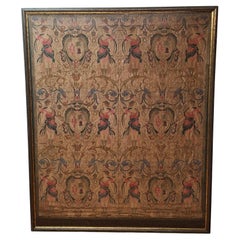
Late 18th-Early 19th C. Venetian Tapestry
Located in San Francisco, CA
Late 18th- early 19th century framed silk embroidered tapestry in a stunning blend of intricate design and rich colors that will enhance any de...
Category
Antique Late 18th Century European Renaissance Tapestries
Materials
Silk
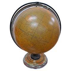
Cram's 16" Deluxe Globe W/Daily Sun Ray and Season Indicator
Located in San Francisco, CA
Cram's 16" Deluxe Globe W/Daily Sun Ray and Season Indicator
1936
Category
Vintage 1930s Maps
Materials
Metal
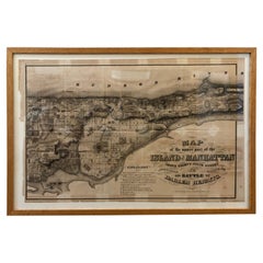
1868 Map of the Upper Part of the Island of Manhattan Above 86th Street
By Wm. Rogers Mfg. Co.
Located in San Francisco, CA
This wonderful piece of New York City history is over 150 years old. It depicts 86th street and above. It was lithographed by WC Rogers and company. It was made to show what was the Battle of Harlem during the Revolutionary war...
Category
Antique 1860s American American Colonial Maps
Materials
Paper
19th Century Shakespeare 10 Volumes, circa 1894
Located in San Francisco, CA
19th century Shakespeare 10 volumes, circa 1894
Edited by William Aldis Wright
Macmillan and Co., London and New York
Each volume measures 7" wide x 10.5" high
Offered as...
Category
Antique Late 19th Century American Books
Materials
Paper
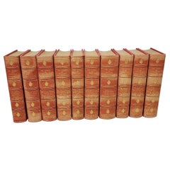
$1,650 / set
Paul Slapion 'American, 20th Century' Mixed-Media Abstract Painting, circa 1985
Located in San Francisco, CA
Paul Slapion (American, 20th century) mixed-media abstract painting
Title: In Each of Us...All of Us #2,
circa 1985
A fine mixed-media painting created with many layers of glass, ink and oils.
Visually stunning optical art.
Dimensions: 16 inches x 20 inches.
Frame dimensions: 20.25 inches x 16.25 inches.
Very good vintage condition. Lightly distressed frame.
Signed verso with the original "OK Harris Gallery, NY" label.
The OK Harris Gallery was an art gallery located at 383 West Broadway...
Category
Late 20th Century American Modern Paintings
Materials
Glass, Paint

You May Also Like
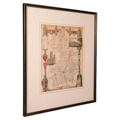
Antique Lithography Map, Derbyshire, English, Framed Cartography, Victorian
Located in Hele, Devon, GB
This is an antique lithography map of Derbyshire. An English, framed atlas engraving of cartographic interest, dating to the mid 19th century and later.
Superb lithography of Derby...
Category
Antique Mid-19th Century British Victorian Maps
Materials
Glass, Wood, Paper

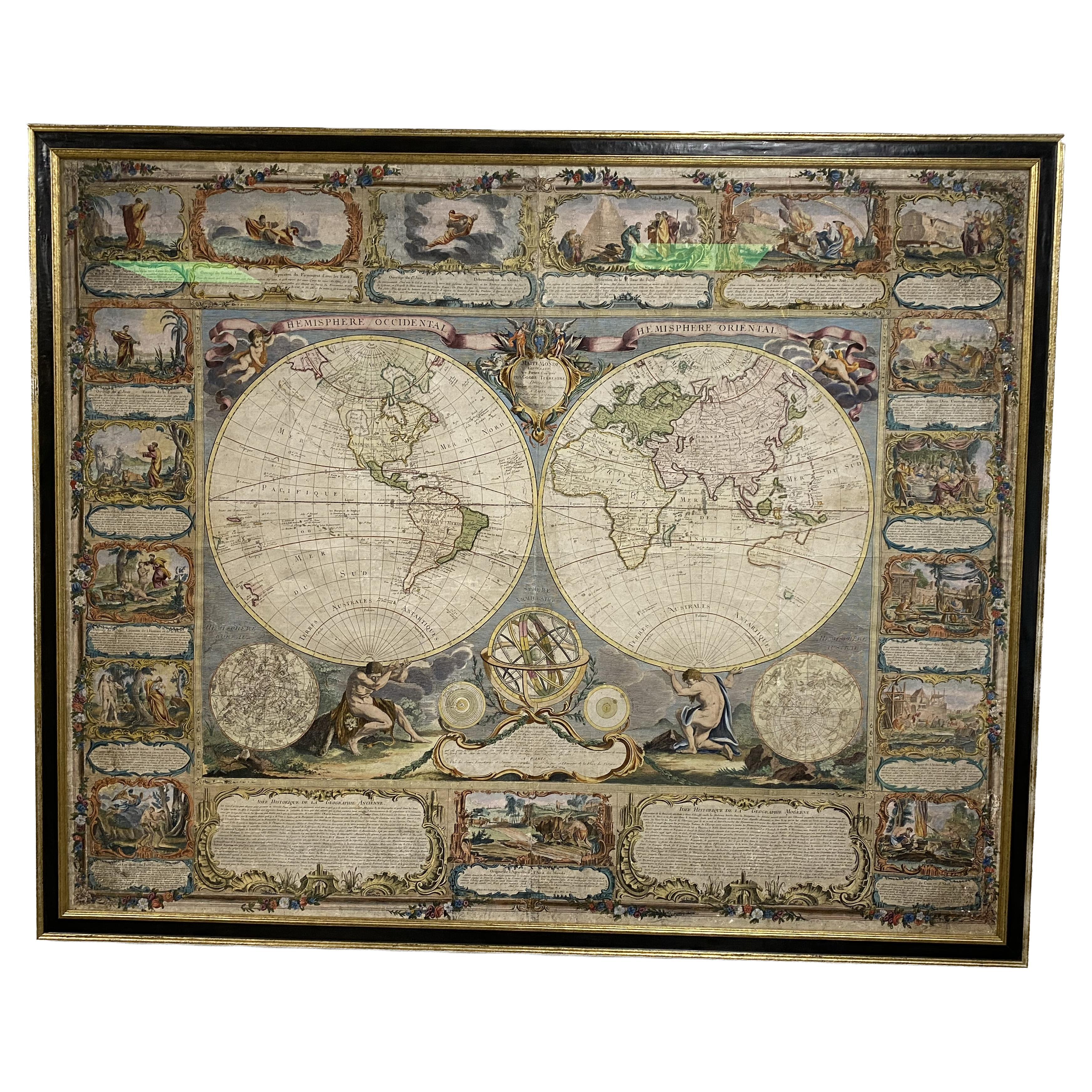
Colored wall map of the WORLD
By Chambon
Located in ZWIJNDRECHT, NL
“Mappe Monde, contenant les Parties Connues du Globe Terrestre”
CHAMBON, Gobert-Denis (France, 17.. - 1781)
Paris, Longchamps et Janvier, 1754
Size H. 115 x W. 145 cm.
Gobert-Denis Chambon made copper engraving after the work of Guillaume De L’Isle, published in 1754 by Jean Janvier and S.G. Longschamps.
A huge wall map of the world in two hemispheres printed on two sheets, depicting the Eastern and Western hemispheres supported by two male figures, decorated at the bottom right and left with two celestial hemispheres (boreal and southern) and at the bottom in the middle with an armillary sphere, in addition.
This map is most notable for its depiction of the Sea of Japan labeled "Mer de Corée" and of "Mer de L'Ouest" or Sea of the West - a great sea, easily the size of the Mediterranean, to flow from the then-known Strait of Juan de Fuca...
Category
Antique Mid-18th Century French French Provincial Maps
Materials
Wood, Paper

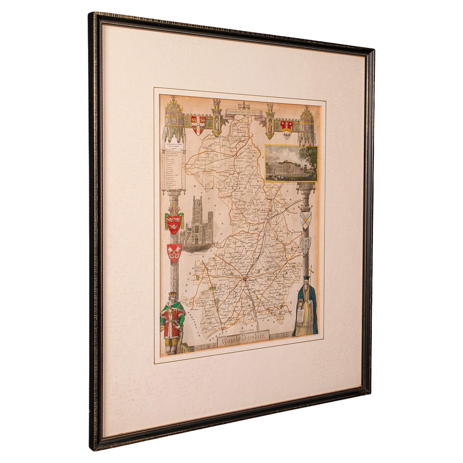
Antique Lithography Map, Cambridgeshire, English, Framed Cartography, Victorian
Located in Hele, Devon, GB
This is an antique lithography map of Cambridgeshire. An English, framed atlas engraving of cartographic interest, dating to the mid 19th century and later.
Superb lithography of C...
Category
Antique Mid-19th Century British Victorian Maps
Materials
Glass, Wood, Paper
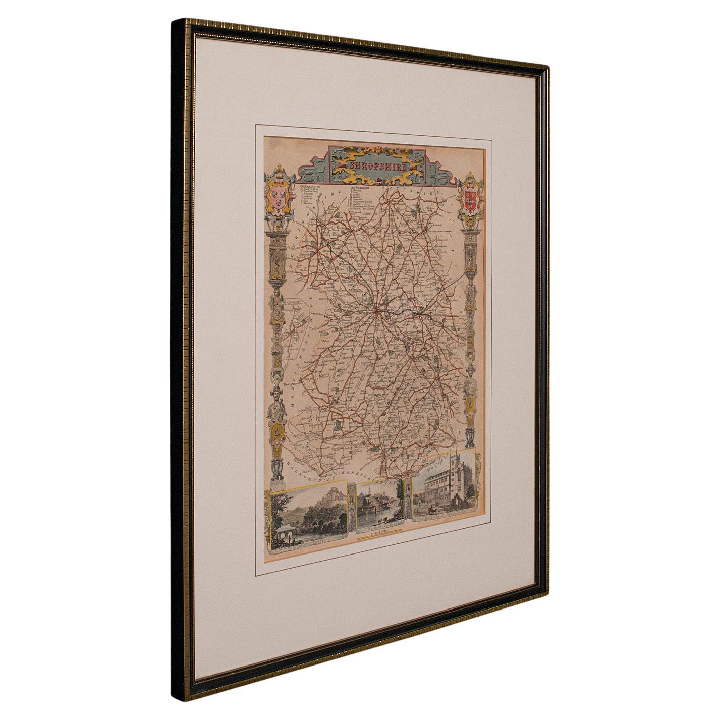
Antique Lithography Map, Shropshire, English, Framed, Cartography, Victorian
Located in Hele, Devon, GB
This is an antique lithography map of Shropshire. An English, framed atlas engraving of cartographic interest, dating to the mid 19th century and later.
Superb lithography of Shrop...
Category
Antique Mid-19th Century British Victorian Maps
Materials
Wood

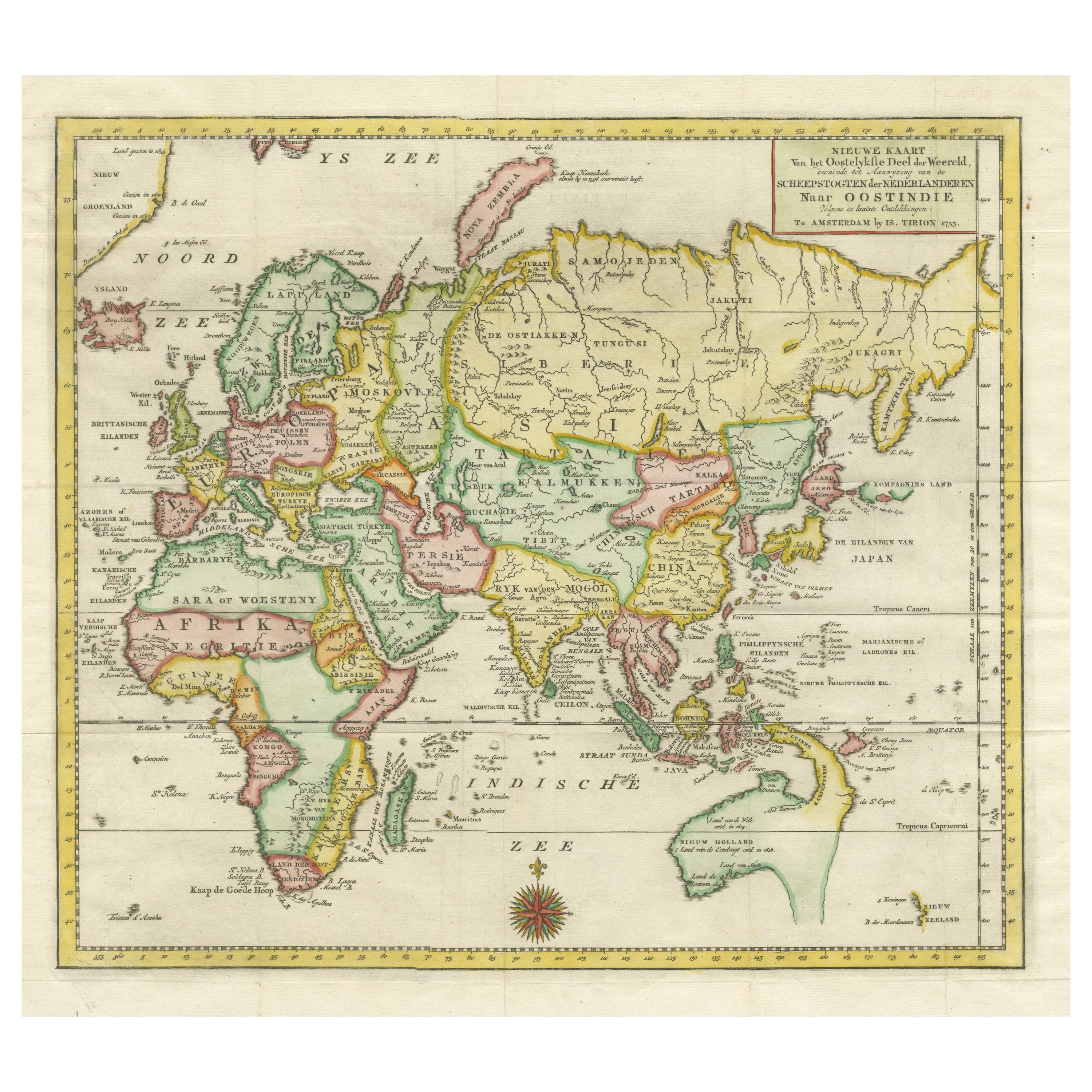
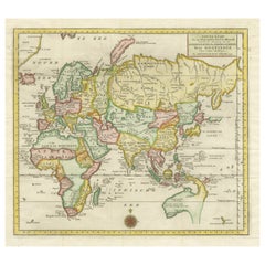
Antique Map of the Eastern Part of the World
Located in Langweer, NL
Antique map titled 'Nieuwe Kaart van het Oostelykste Deel der Weereld, diendende tot aanwyzing van de Scheepstogten der Nederlanderen Naar Oostindie'. This finely engraved map of the...
Category
Antique Mid-18th Century Maps
Materials
Paper
Vintage Reproduction 17th Century Map of Europe, American, Cartography, Blaeuw
Located in Hele, Devon, GB
This is a vintage reproduction map of Europe. An American, paper stock cartography print in frame after the work by Blaeuw, dating to the late 20t...
Category
Late 20th Century Central American Mid-Century Modern Maps
Materials
Glass, Wood, Paper

More Ways To Browse
Antique Celluloid
Antique Love Letter
Antique Pennsylvania Cabinet
Antique Seeded Glass
Antique Silver Cigarette Case
Boulle 18th Century
British Antique Clocks
Bronze Cameo
Byobu Panel
Chest With Hidden Commode
China Porcelain Dogs
Chinese Court Paintings
Copper Lined Cabinet
Counter Kitchen Island
Dimpled Glass
File Box
Filing Black Cabinet
Florentine Cabinet