Items Similar to Antique Print of the Coast from Elmina to Moree, West-Africa, 1748

Want more images or videos?
Request additional images or videos from the seller
1 of 6
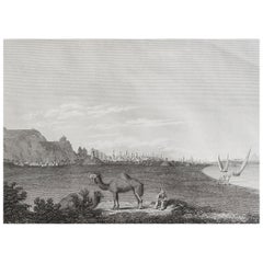
Antique Print of the Coast from Elmina to Moree, West-Africa, 1748
$210.43
$263.0420% Off
£155.78
£194.7320% Off
€176
€22020% Off
CA$291.18
CA$363.9820% Off
A$321.02
A$401.2720% Off
CHF 167.95
CHF 209.9320% Off
MX$3,938.31
MX$4,922.8920% Off
NOK 2,114.12
NOK 2,642.6520% Off
SEK 1,977.04
SEK 2,471.3020% Off
DKK 1,340.66
DKK 1,675.8320% Off
About the Item
Antique print titled 'Vue de la Côte depuis Mina jusquáu Maure - Gezigt van de Kust, van Del-Mina tot Moure'. View of the coast from Elmina to Moree. This print originates from 'Historische beschryving der reizen, of Nieuwe en volkoome verzameling van de aller-waardigste en zeldsaamste Zee- en Landtogten' by P. de Hondt.
Artists and Engravers: Engraved by Jakob van der Schley (Amsterdam 1715-1779), a Dutch draughtsman and engraver. He studied under Bernard Picart and became heavily influenced by his style.
Condition: Good, age-related toning, Original folding lines, blank verso. Please study image carefully.
Date: 1748
Overall Size: 37.5 x 25.5 cm.
Image Size: 28 x 19 cm.
Antique prints have long been appreciated for both their aesthetic and investment value. They were the product of engraved, etched or lithographed plates. These plates were handmade out of wood or metal, which required an incredible level of skill, patience and craftsmanship. Whether you have a house with Victorian furniture or more contemporary decor an old engraving can enhance your living space. We offer a wide range of authentic antique prints for any budget.
- Dimensions:Height: 10.04 in (25.5 cm)Width: 14.77 in (37.5 cm)Depth: 0 in (0.01 mm)
- Materials and Techniques:
- Period:
- Date of Manufacture:1748
- Condition:Condition: Good, age-related toning, Original folding lines, blank verso. Please study image carefully.
- Seller Location:Langweer, NL
- Reference Number:Seller: CD-123551stDibs: LU3054329565992
About the Seller
5.0
Recognized Seller
These prestigious sellers are industry leaders and represent the highest echelon for item quality and design.
Platinum Seller
Premium sellers with a 4.7+ rating and 24-hour response times
Established in 2009
1stDibs seller since 2017
2,613 sales on 1stDibs
Typical response time: <1 hour
- ShippingRetrieving quote...Shipping from: Langweer, Netherlands
- Return Policy
Authenticity Guarantee
In the unlikely event there’s an issue with an item’s authenticity, contact us within 1 year for a full refund. DetailsMoney-Back Guarantee
If your item is not as described, is damaged in transit, or does not arrive, contact us within 7 days for a full refund. Details24-Hour Cancellation
You have a 24-hour grace period in which to reconsider your purchase, with no questions asked.Vetted Professional Sellers
Our world-class sellers must adhere to strict standards for service and quality, maintaining the integrity of our listings.Price-Match Guarantee
If you find that a seller listed the same item for a lower price elsewhere, we’ll match it.Trusted Global Delivery
Our best-in-class carrier network provides specialized shipping options worldwide, including custom delivery.More From This Seller
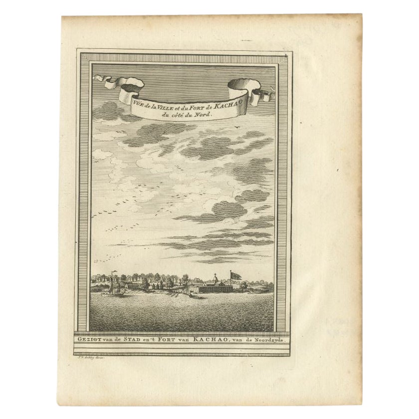
View AllAntique Print of the City and Fortress of Kachao in Guinea Bissau, Africa, 1747
By Jakob van der Schley
Located in Langweer, NL
Antique print titled 'Gezigt van de Stad en 't Fort van Kachao'. View of the city and Fortress of Kachao, Guinea Bissau, Africa. Engraved by J. van Schley for a Dutch edition of 'l'H...
Category
Antique 18th Century Prints
Materials
Paper
$219 Sale Price
20% Off
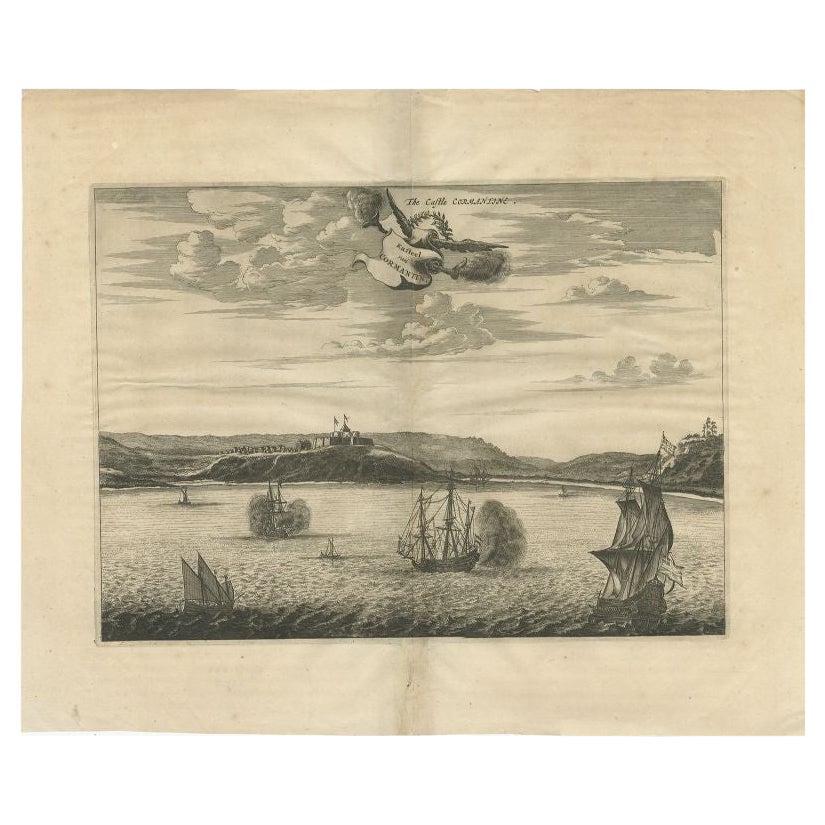
Antique Print of a Fort on the Gold Coast of Africa by Dapper, c.1670
Located in Langweer, NL
`Antique print titled 'Kasteel van Cormantin/The castle Cormantine'. Fine engraving depicting one of the forts on the Gold Coast of Africa. Cormantine Castle first was a British fort...
Category
Antique 17th Century Prints
Materials
Paper
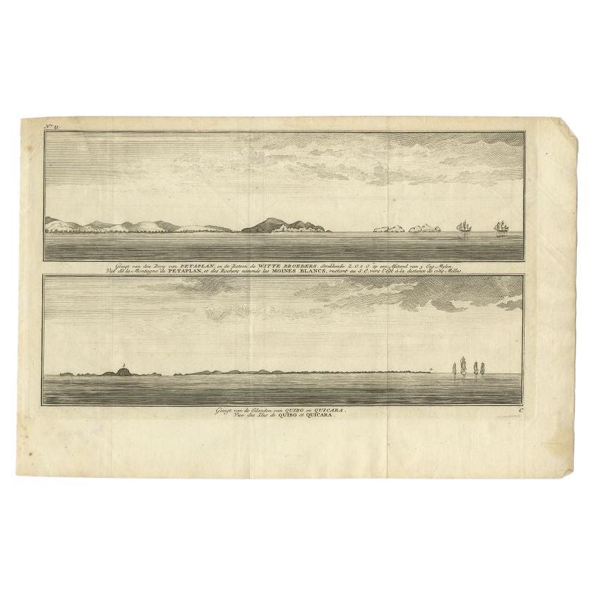
Antique Print of Petatlan and Coiba Island, Near Mexico and Panama, 1749
Located in Langweer, NL
Antique print titled 'Vue de la Montagne de Petaplan, et des rochers nommés les Moines Blancs, restant au S.E. vers l'est a la distance de cinq milles' and Vue des Iles de Quibo et Q...
Category
Antique 18th Century Prints
Materials
Paper
$133 Sale Price
20% Off
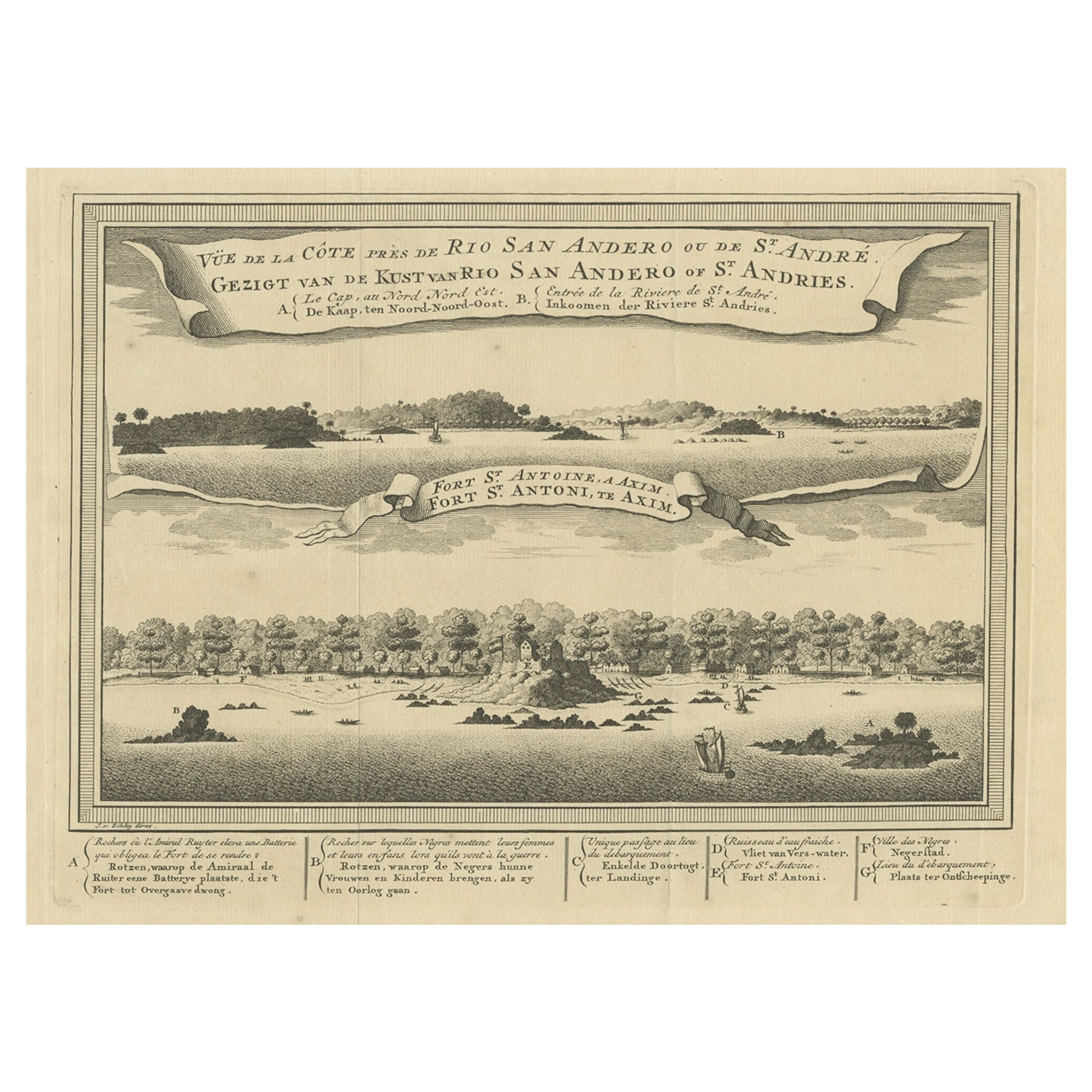
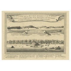
Antique Print of a Fort on the Ivory Coast and Axim, Africa, 1748
By Jakob van der Schley
Located in Langweer, NL
Antique print titled 'Vue de la Cote pres de Rio San Andero - Gezigt van de Kust van Rio San Andero' and 'Fort St. Antoine a Axim - Fort St. Antoni, te Axim'. View of the Ivory coast...
Category
Antique 18th Century Prints
Materials
Paper
$277 Sale Price
20% Off
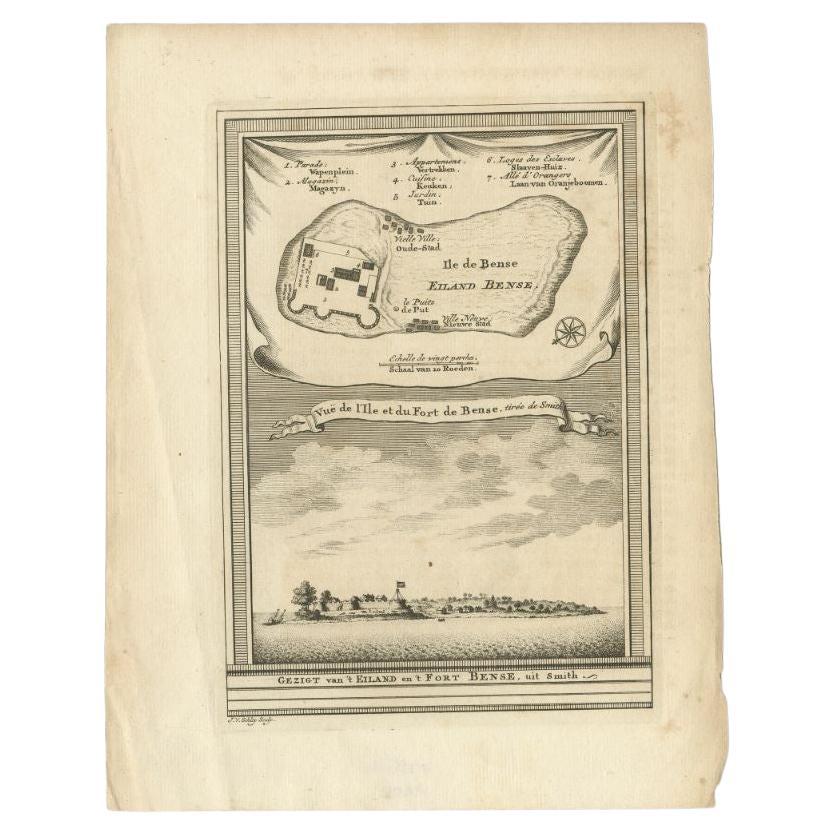
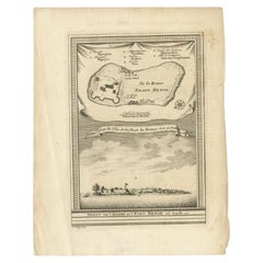
Antique Print of Bunce Island an Island in the Sierra Leone River, 1748
By Jakob van der Schley
Located in Langweer, NL
Antique print titled 'Vue de l'Ile et du Fort de Bense, tirée de Smith - Gezigt van 't Eiland en 't Fort Bense, uit Smith'. This print depicts Bunce Island, an island in the Sierra L...
Category
Antique 18th Century Prints
Materials
Paper
$210 Sale Price
20% Off
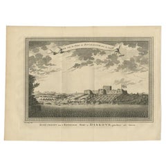
Antique Print of the English Fort at Dixcove in Ghana, 1748
Located in Langweer, NL
Antique print titled 'Vue sud du Fort de Dickscove - Zuid-gezigt van 't Engelsse Fort te Dixkove'. View of the English fort at Dixcove, Ghana. This print originates from 'Historische...
Category
Antique 18th Century Prints
Materials
Paper
$153 Sale Price
20% Off
You May Also Like
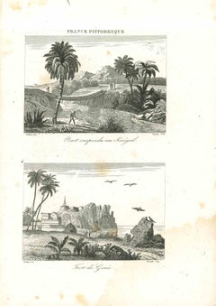
Views of Senegal - Original Lithograph - 19th century
Located in Roma, IT
Views of Senegal is an original lithograph artwork realized by an Anonymous engraver of the 19th century.
Printed in the series of "France Pittoresque".
Titled "France Pittoresqu...
Category
19th Century Modern Figurative Prints
Materials
Lithograph
Original Antique Print of Cairo, Egypt. Dated 1809
Located in St Annes, Lancashire
Wonderful image of Cairo
Fine copper-plate engraving
Published by Sherwood & Co.
Dated 1809
Unframed.
Free shipping
Category
Antique Early 1800s English Moorish Prints
Materials
Paper
Ancient View of La Valetta - Original Lithograph - Early-19th Century
Located in Roma, IT
La Valetta is an original modern artwork realized in Italy in the first half of the 19th Century.
Original Lithograph on Ivory Paper.
Inscripted in capital letters on the lower ma...
Category
1850s Modern Figurative Prints
Materials
Lithograph
Antique Voc Print Holland Malaysia Old Map Melaka History, 1663
Located in Amsterdam, Noord Holland
From my own collection I offer this impressive Antique print of the city of Malakka
A very interesting piece for collectors . It is an museum piece from the Dutch Institute of Orien...
Category
Antique 17th Century European Paintings
Materials
Paper

$293 Sale Price
20% Off
Ancient View of La Valetta - Original Lithograph - Early-19th Century
Located in Roma, IT
La Valetta is an original modern artwork realized in Italy in the first half of the 19th Century.
Original Lithograph on Ivory Paper.
Inscripted in capital letters on the lower ma...
Category
1850s Modern Figurative Prints
Materials
Lithograph
Seascape with Monument and Figures - Etching by F. Cepparuli - 18th Century
By Francesco Cepparuli
Located in Roma, IT
Seascape With Monuments is an Etching realized by Francesco Cepparuli (1750-1767).
The etching belongs to the print suite “Antiquities of Herculaneum Exposed” (original title: “Le A...
Category
Late 18th Century Old Masters Figurative Prints
Materials
Etching
More Ways To Browse
Chest On Chest Dresser Antique
Childs Chair Rush Seat
Chippendale Highboy Dresser
Chippendale Mahogany Lowboy
Chippendale Mahogany Secretary Desk
Chippendale Tiger Maple
Clam Pearl
Clodion Statue Sculpture
Colinet Bronze
Compact Cigarette Case
Conny Walther
Coustou Bronze Marly Horse
Crock Vase
Crown Religious
Curtis Jere Flower
Curtis Jere Urchin
De Rambouillet
Dining Room Inspiration