Items Similar to Engraving of Alejandro Selkirk Island, Juan Fernández-archipel, Chile, 1749


Want more images or videos?
Request additional images or videos from the seller
1 of 6
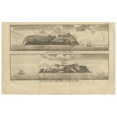
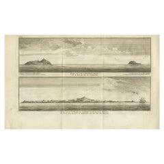
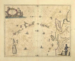
Engraving of Alejandro Selkirk Island, Juan Fernández-archipel, Chile, 1749
$209.20
$261.5020% Off
£155.79
£194.7320% Off
€176
€22020% Off
CA$288.83
CA$361.0320% Off
A$320.21
A$400.2620% Off
CHF 168.28
CHF 210.3520% Off
MX$3,918.81
MX$4,898.5120% Off
NOK 2,101.66
NOK 2,627.0820% Off
SEK 1,972.62
SEK 2,465.7720% Off
DKK 1,340.01
DKK 1,675.0120% Off
About the Item
Antique print titled 'Vue de la cote du N. E. de Masa-Fuero' - 'Vue de la cote occidentale de Masa-Fuero a la distance de quatre milles.' Views of Alejandro Selkirk Island, previously known as Más Afuera, Juan Fernández Islands. This print originates from 'Reize rondsom de Werreld (..)' by George Anson, published 1749.
Artists and Engravers: Admiral of the Fleet George Anson, 1st Baron Anson, PC, FRS (23 April 1697 – 6 June 1762) was a Royal Navy officer.
Condition: Fair, general age-related toning. Tape on upper corners. Minor defects and some creasing, please study image carefully.
Date: 1749
Overall size: 41.5 x 27 cm.
Image size: 36.5 x 21 cm.
Whilst cartography holds a special place in our collection, we also offer thousands of antique prints covering fields of interest as diverse as architecture, natural history, religion, ethnology and many more. Antique prints have long been appreciated for both their aesthetic and investment value. They were the product of engraved, etched or lithographed plates. These plates were handmade out of wood or metal, which required an incredible level of skill, patience and craftsmanship. Whether you have a house with Victorian furniture or more contemporary decor an old engraving can enhance your living space.
- Dimensions:Height: 10.63 in (27 cm)Width: 16.34 in (41.5 cm)Depth: 0 in (0.01 mm)
- Materials and Techniques:
- Period:
- Date of Manufacture:1749
- Condition:Condition: Fair, general age-related toning. Tape on upper corners. Minor defects and some creasing, please study image carefully.
- Seller Location:Langweer, NL
- Reference Number:Seller: BGI-007361stDibs: LU3054329334172
About the Seller
5.0
Recognized Seller
These prestigious sellers are industry leaders and represent the highest echelon for item quality and design.
Platinum Seller
Premium sellers with a 4.7+ rating and 24-hour response times
Established in 2009
1stDibs seller since 2017
2,609 sales on 1stDibs
Typical response time: <1 hour
- ShippingRetrieving quote...Shipping from: Langweer, Netherlands
- Return Policy
Authenticity Guarantee
In the unlikely event there’s an issue with an item’s authenticity, contact us within 1 year for a full refund. DetailsMoney-Back Guarantee
If your item is not as described, is damaged in transit, or does not arrive, contact us within 7 days for a full refund. Details24-Hour Cancellation
You have a 24-hour grace period in which to reconsider your purchase, with no questions asked.Vetted Professional Sellers
Our world-class sellers must adhere to strict standards for service and quality, maintaining the integrity of our listings.Price-Match Guarantee
If you find that a seller listed the same item for a lower price elsewhere, we’ll match it.Trusted Global Delivery
Our best-in-class carrier network provides specialized shipping options worldwide, including custom delivery.More From This Seller
View AllAntique Print with Views of Alejandro Selkirk Island by Anson '1749'
Located in Langweer, NL
Antique print titled 'Vue de la cote du N. E. de Masa-Fuero' - 'Vue de la cote occidentale de Masa-Fuero a la distance de quatre milles.' Views of Alejandro Selkirk Island...
Category
Antique Mid-18th Century Prints
Materials
Paper
$190 Sale Price
36% Off
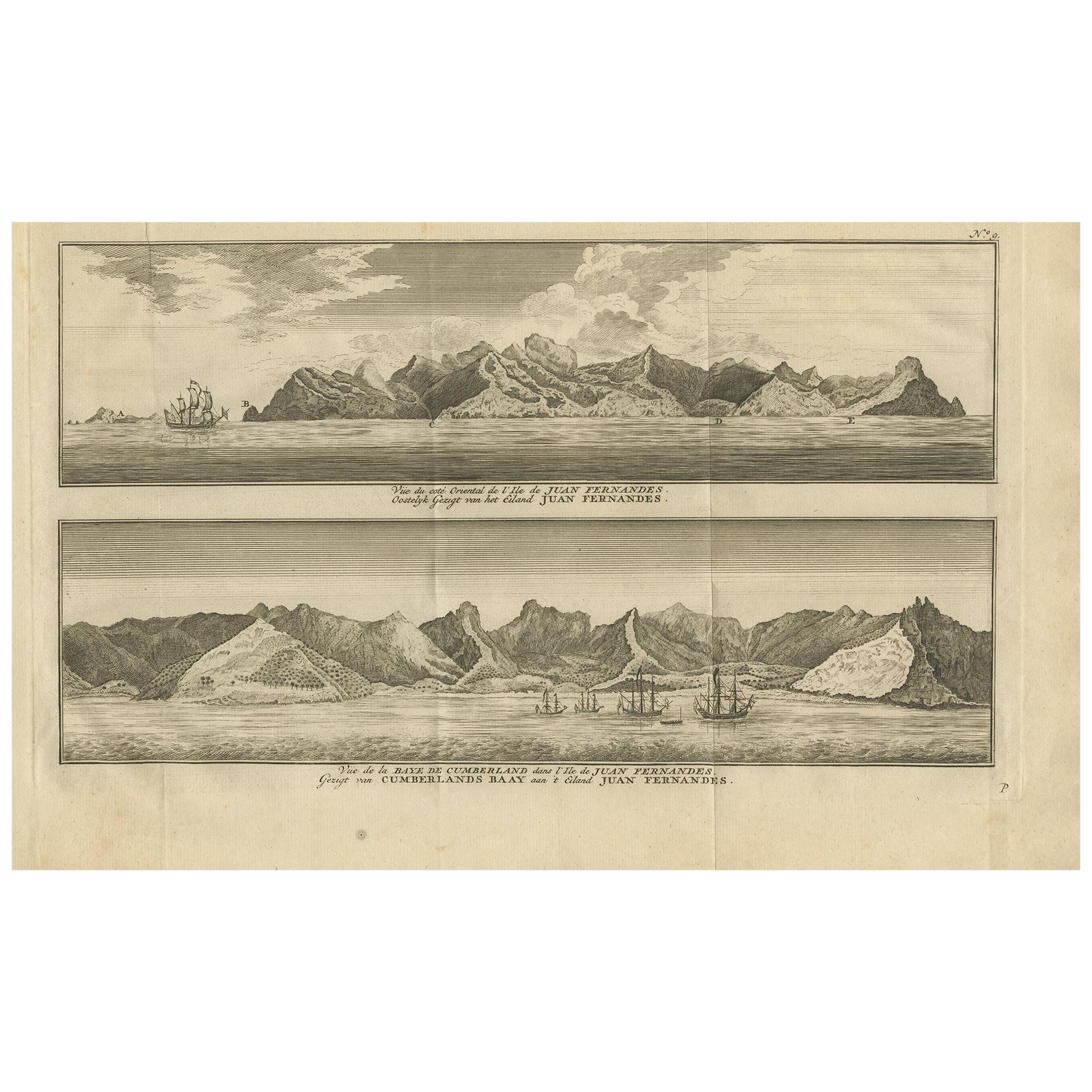
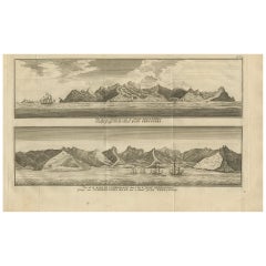
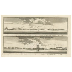
Antique Print of Cumberland Bay and Juan Fernandez Island by Anson, 1749
Located in Langweer, NL
Antique print titled 'Vue du cote oriental de l'Ile de Juan Fernandes.' 'Vue de la Baye de Cumberland dans l'Ile de Juan Fernandes.' Eastern view of Juan Fernandez Island; View of th...
Category
Antique Mid-18th Century Prints
Materials
Paper
$180 Sale Price
39% Off
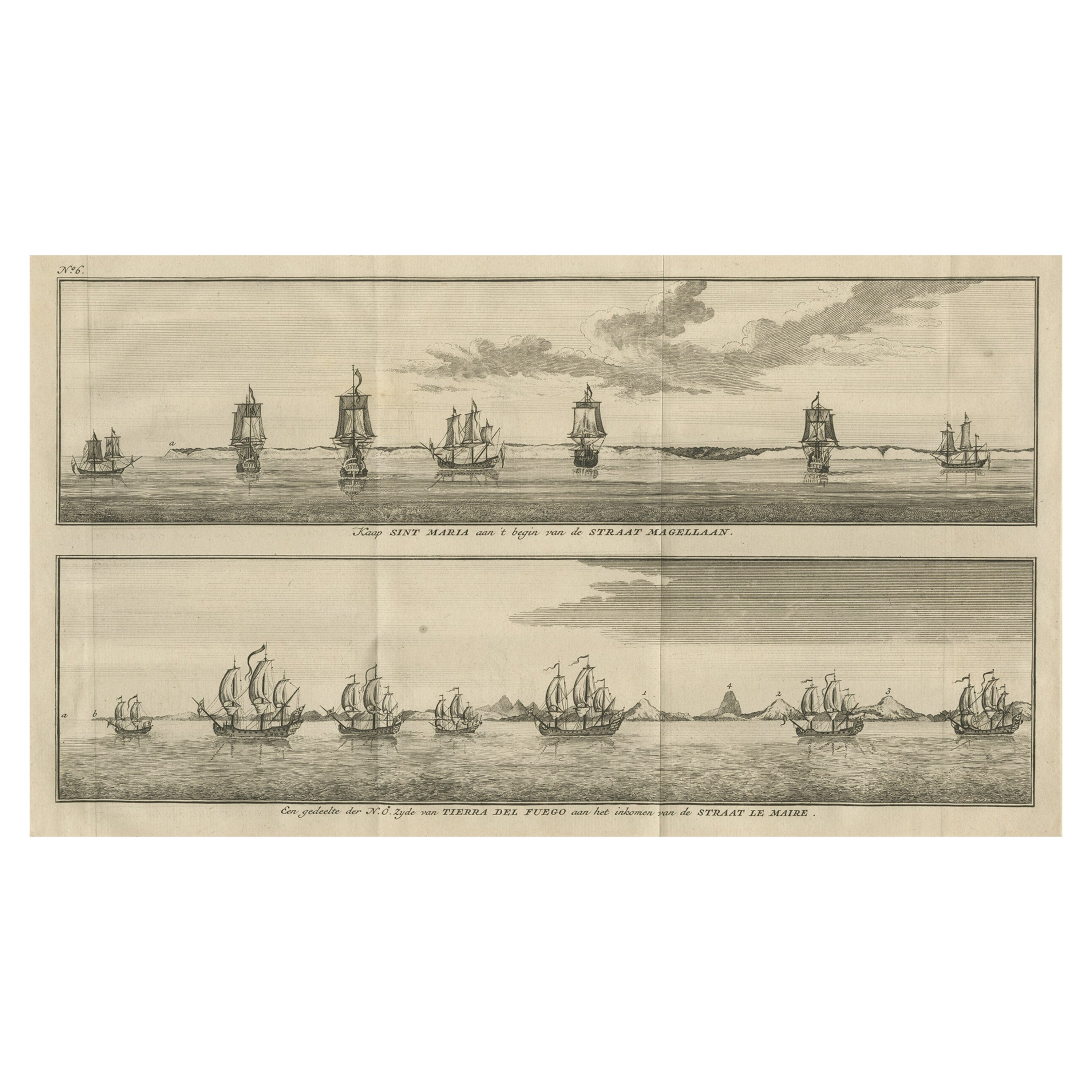
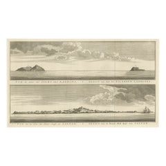
Old Views of Cabo Santa Maria & Tierra del Fuego, Chile, 1749
Located in Langweer, NL
Antique print titled 'Kaap Sint Maria aan 't begin van de Straat Magellaan (..)'. Coastal views of Cabo Santa Maria and Tierra del Fuego on the Argent...
Category
Antique 18th Century Prints
Materials
Paper
$180 Sale Price
30% Off
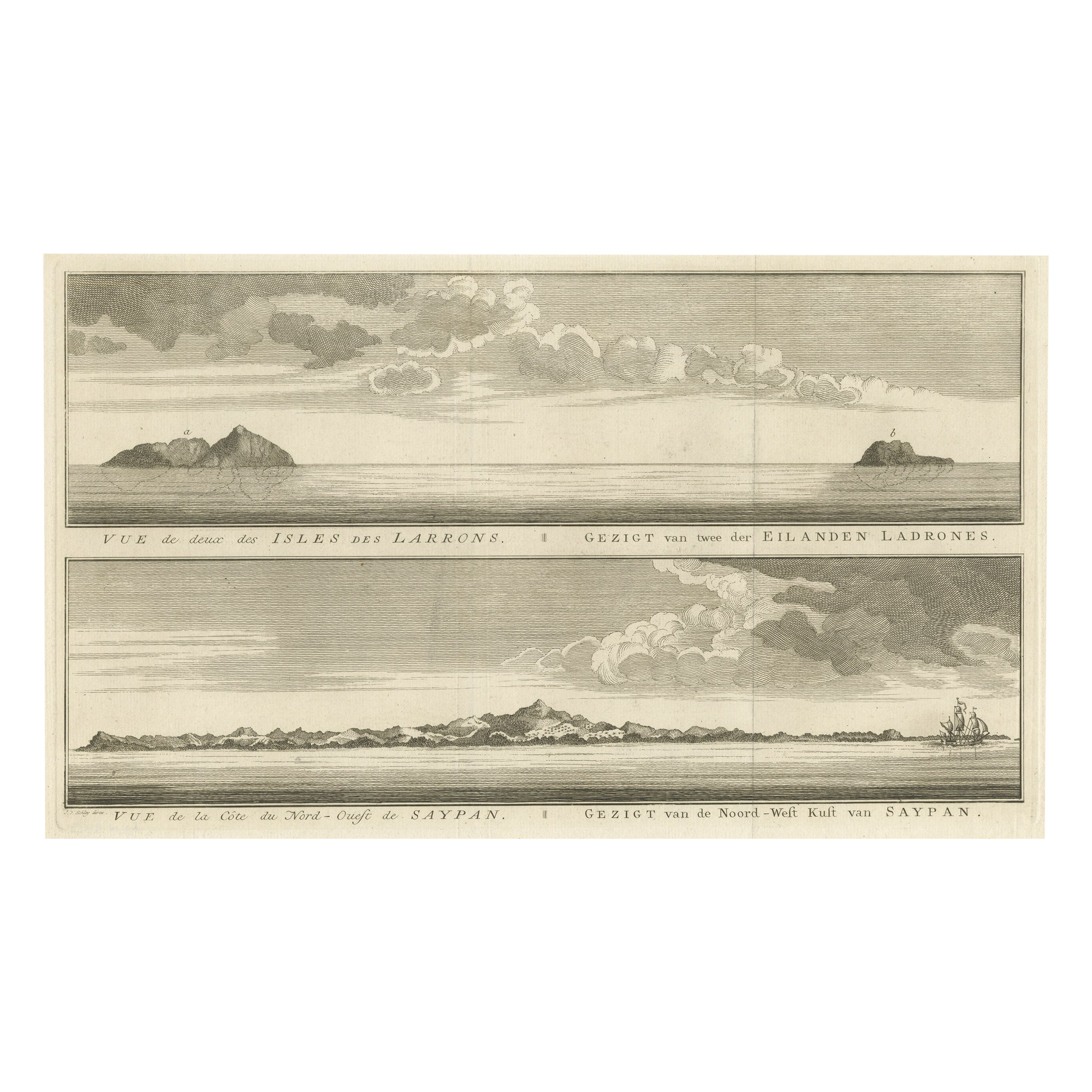
Antique View of The N.W. side of Saypan and one of The Ladrones Islands, 1757
Located in Langweer, NL
Antique print titled 'Vue de deux des Iles des Larrons - Gezigt van twee der Eilanden Ladrones (..)'.
View of two Ladrones Islands; View of the N.W. side of Saypan, one of the La...
Category
Antique 1750s Prints
Materials
Paper
$342 Sale Price
20% Off
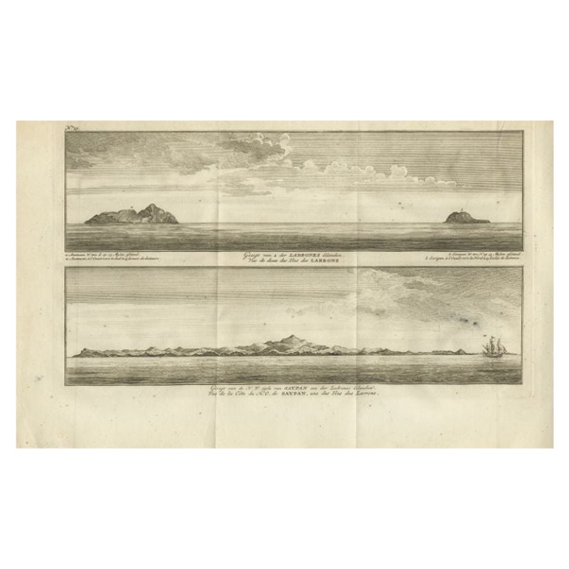
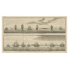
Antique Print with Views of the Ladrones Islands and Saipan by Anson, 1749
Located in Langweer, NL
Antique print titled 'Gezigt van 2 der Ladrones Eilanden' and 'Gezigt van de N.W. zyde van Saypan'. Coastal views of the Ladrones Islands and the island of Saipan. This print origina...
Category
Antique 18th Century Prints
Materials
Paper
$218 Sale Price
29% Off
Antique Engraving of Tinian, an Island of the Northern Mariana Islands, 1757
Located in Langweer, NL
Antique print titled 'Vue de la Rde de Tinian
Gezigt van de Rheede van Tinian (..)'. Views of the south-west side of the island of Tinian and a view of the anchorage of Tinian, w...
Category
Antique 1750s Prints
Materials
Paper
$342 Sale Price
20% Off
You May Also Like
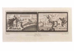
Seascapes with Monuments and Figures - Etching by Luigi Aloja - 18th Century
Located in Roma, IT
Seascapes With Monuments and Figures is an Etching realized by Luigi Aloja (1783-1837).
The etching belongs to the print suite “Antiquities of Herculaneum Exposed” (original title:...
Category
Late 18th Century Old Masters Figurative Prints
Materials
Etching
1844 French Antique Nautical print Engraved Portolano of Syrie by Antoine Roux
By Antoine Roux
Located in Milan, IT
Antique portolano, nautical map of Syrie engraved on a copper plate by Antoine Roux, Marseille France 1844, from his work Recueil des principaux plans des ports et de Rades de la Mer...
Category
Antique 1840s French Nautical Objects
Materials
Paper
S.Juan de Puerto Rico - Etching by Johannes Janssonius - 1650s
By Johannes Janssonius
Located in Roma, IT
S.Juan de Puerto Rico is an ancient map realized in 1650 by Johannes Janssonius (1588-1664).
Good conditions.
From Atlantis majoris quinta pars, Orbem maritimum [Novus Atlas, volum...
Category
1650s Modern Figurative Prints
Materials
Etching
Seascape with Monuments - Etching by Luigi Aloja - 18th Century
Located in Roma, IT
Seascape With Monuments is an Etching realized by Luigi Aloja (1783-1837).
The etching belongs to the print suite “Antiquities of Herculaneum Exposed” (original title: “Le Antichit...
Category
Late 18th Century Old Masters Figurative Prints
Materials
Etching
Original Antique Map of South America. C.1780
Located in St Annes, Lancashire
Great map of South America
Copper-plate engraving
Published C.1780
Two small worm holes to left side of map
Unframed.
Category
Antique Early 1800s English Georgian Maps
Materials
Paper

Seascape - Etching by Giuseppe Aloja - 18th Century
Located in Roma, IT
Seascapes is an Etching realized by Luigi Aloja (1783-1837).
The etching belongs to the print suite “Antiquities of Herculaneum Exposed” (original title: “Le Antichità di Ercolano ...
Category
18th Century Old Masters Figurative Prints
Materials
Etching
More Ways To Browse
Pompeii Wall Painting
Priest Japanese
Rooster Garden
Rosewood Record
Santo Head
Sarreid Brass Spain
Scandinavian China Cabinet
Sculpture Cheval
Sea Shell Glass Tables
Serpentine Secretary
Shishi Lion
Signed Ginger Jars
Spanish Baroque Columns
St Charles Kitchen
Sterling Cane
Stone Bench With Back
Stork Gold
Swatch 1993