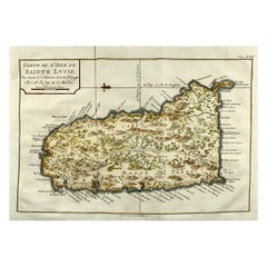
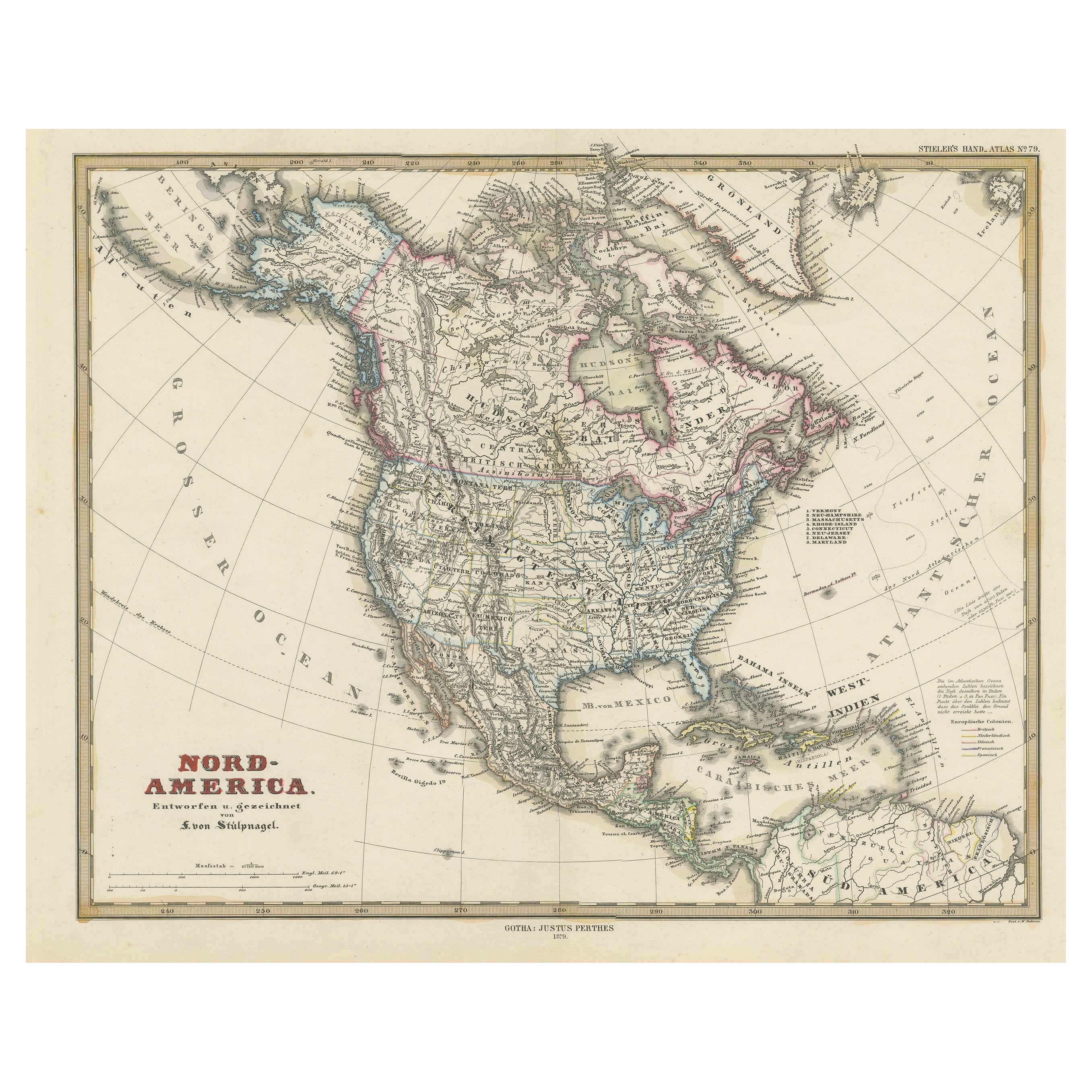
Jacques Nicolas Bellin, St Lucia, West Indies, Hand Colored Map
View Similar Items


Want more images or videos?
Request additional images or videos from the seller
1 of 5
Jacques Nicolas Bellin, St Lucia, West Indies, Hand Colored Map
About the Item
- Creator:Jacques-Nicolas Bellin (Artist)
- Dimensions:Height: 8.08 in (20.5 cm)Width: 11.82 in (30 cm)Depth: 0.04 in (1 mm)
- Style:Georgian (Of the Period)
- Materials and Techniques:
- Place of Origin:
- Period:1770-1779
- Date of Manufacture:1775
- Condition:Wear consistent with age and use.
- Seller Location:Norwich, GB
- Reference Number:1stDibs: LU7031229958032

Jacques-Nicolas Bellin
Jacques Nicolas Bellin (1703 –1772) was a French hydrographer (official cartographer) and a geographer. While still a teenager he became the chief cartographer to the French Navy and later to the king of France. Bellin created a large number of maps for Antoine François Prévost's (L'Abbe Prevost) 'Histoire Generale des Voyages', which was a 25 volume publication focused on 17th and 18th century exploration.It was published in French, Dutch and German. He also contributed maps and articles to the 35-volume Encyclopédie edited by Denis Diderot and Jean le Rond d'Alembert. He was part of the group called Philosophes, which included many of the great intellectuals of the Age of Enlightenment, including Voltaire, Rousseau and Montesquieu. Bellin died at Versailles in 1772.
About the Seller
No Reviews Yet
Vetted Professional Seller
Every seller passes strict standards for authenticity and reliability
Established in 1992
1stDibs seller since 2022
10 sales on 1stDibs
Authenticity Guarantee
In the unlikely event there’s an issue with an item’s authenticity, contact us within 1 year for a full refund. DetailsMoney-Back Guarantee
If your item is not as described, is damaged in transit, or does not arrive, contact us within 7 days for a full refund. Details24-Hour Cancellation
You have a 24-hour grace period in which to reconsider your purchase, with no questions asked.Vetted Professional Sellers
Our world-class sellers must adhere to strict standards for service and quality, maintaining the integrity of our listings.Price-Match Guarantee
If you find that a seller listed the same item for a lower price elsewhere, we’ll match it.Trusted Global Delivery
Our best-in-class carrier network provides specialized shipping options worldwide, including custom delivery.More From This Seller
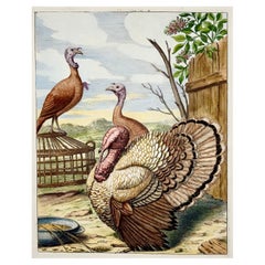
View All1673 Turkey, Poultry, Nicolas Robert, Folio Etching in Hand Color
Located in Norwich, GB
Gibber Coc dinde
Nicolas Robert (18 April 1614 – 25 March 1685)
Issued in the scarce work: Diverses oyseaux dessignées et gravées d'apres le naturel. Pa...
Category
Antique 1670s French Prints
Materials
Paper
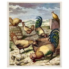
1673 Chickens, Poultry, Nicolas Robert, folio etching in hand colour
Located in Norwich, GB
Coc Gallus Poulle Gallina
Nicolas Robert (18 April 1614 – 25 March 1685)
Issued in the scarce work: Diverses oyseaux dessignées et gravées d'apres le nature...
Category
Antique Late 17th Century French Prints
Materials
Paper
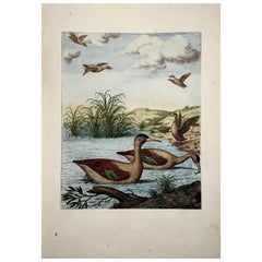
1673 Merganser Ducks, Nicolas Robert Large Folio Etching in Hand Colour
Located in Norwich, GB
Fiber ales Bieure
Nicolas Robert (18 April 1614 – 25 March 1685)
Issued in the scarce work: Diverses oyseaux dessignées et gravées d'apres le naturel. Paris, F. Pilly, (1673).
...
Category
Antique Late 17th Century French Prints
Materials
Paper
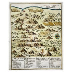
Map of Indonesia, Semarang, Kartasoera, Soerabaya by Schley
By Jakob van der Schley
Located in Norwich, GB
'Carte du Chemin entre Samarang et Cartasoera, kaart van den weg tusschen Samarang en Cartasoera'
Map of the Road between Semarang and Kartasura by Van Schley.
Published 1763.
...
Category
Antique 1760s Indonesian Georgian Prints
Materials
Paper
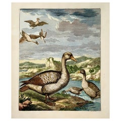
1673 Geese, Nicolas Robert (B.1614), Ornithology, Large Folio Etching
Located in Norwich, GB
Anser; Oye.
Nicolas Robert (18 April 1614 – 25 March 1685)
Issued in the scarce work: Diverses oyseaux dessignées et gravées d'apres le naturel. Paris, F. Pilly, (1673).
Sheet: 36.5 x 24 cm.
Later hand color.
Nissen, IVB 787; Ronsil 2599; see Bradley Martin 1837.
17th century ornithological engraving...
Category
Antique Late 17th Century French Prints
Materials
Paper
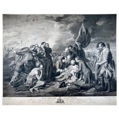
"The Death of General Wolfe", Etching after Benjamin West, laid on vellum
By Benjamin West
Located in Norwich, GB
Etching on laid paper laid down on vellum, around 1789.
Etching after Benjamin West's 1770 painting "The Death of General Wolfe" commemorating the Bat...
Category
Antique 1780s Canadian Georgian Prints
Materials
Paper
You May Also Like
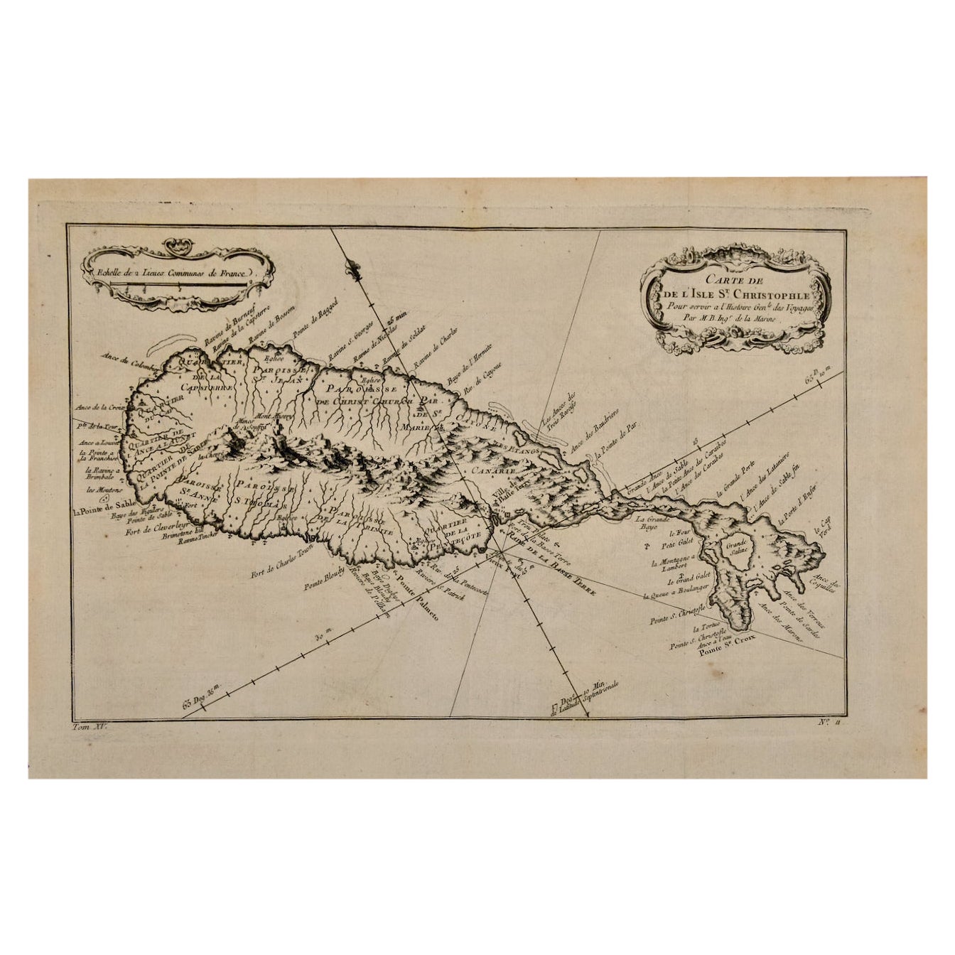
St. Christophe 'St. Kitts' Island: An 18th Century Hand-colored Map by Bellin
By Jacques-Nicolas Bellin
Located in Alamo, CA
Jacques Bellin's copper-plate map of the Caribbean island of Saint Kitts entitled "Carte De De l'Isle St. Christophe Pour servir á l'Histoire Genle. des V...
Category
Antique Mid-18th Century French Maps
Materials
Paper

Captain Cook's Exploration of Tahiti 18th C. Hand-Colored Map by Bellin
By Jacques-Nicolas Bellin
Located in Alamo, CA
This beautiful 18th century hand-colored copper plate engraved map is entitled "Carte de l'Isle de Taiti, par le Lieutenant J. Cook" was created by Jacques Nicolas Bellin and publish...
Category
Antique Mid-18th Century French Maps
Materials
Paper

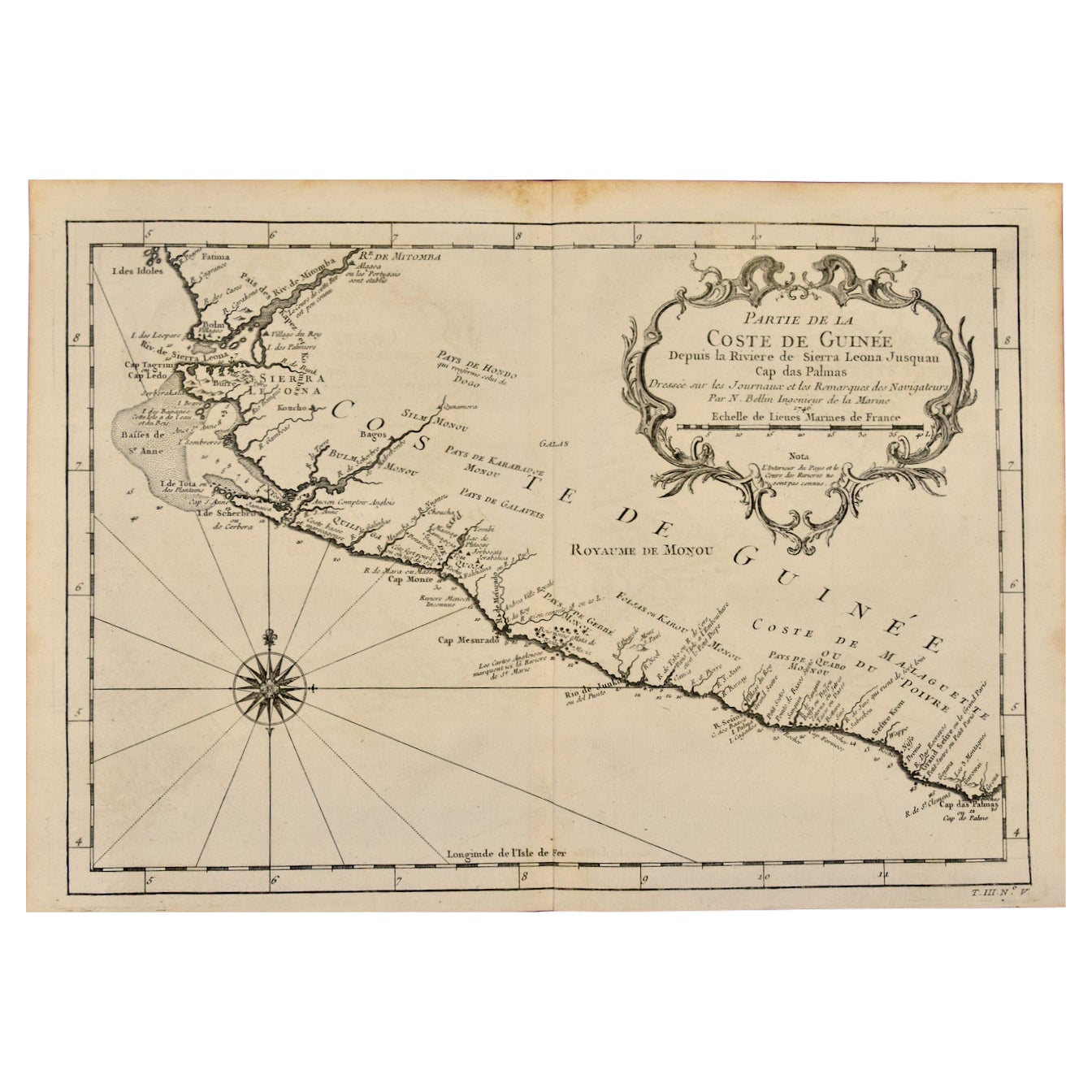
West Coast of Africa, Guinea & Sierra Leone: An 18th Century Map by Bellin
By Jacques-Nicolas Bellin
Located in Alamo, CA
Jacques Bellin's copper-plate map entitled "Partie de la Coste de Guinee Dupuis la Riviere de Sierra Leona Jusquau Cap das Palmas", depicting the coast of Guinea and Sierra Leone in ...
Category
Antique Mid-18th Century French Maps
Materials
Paper

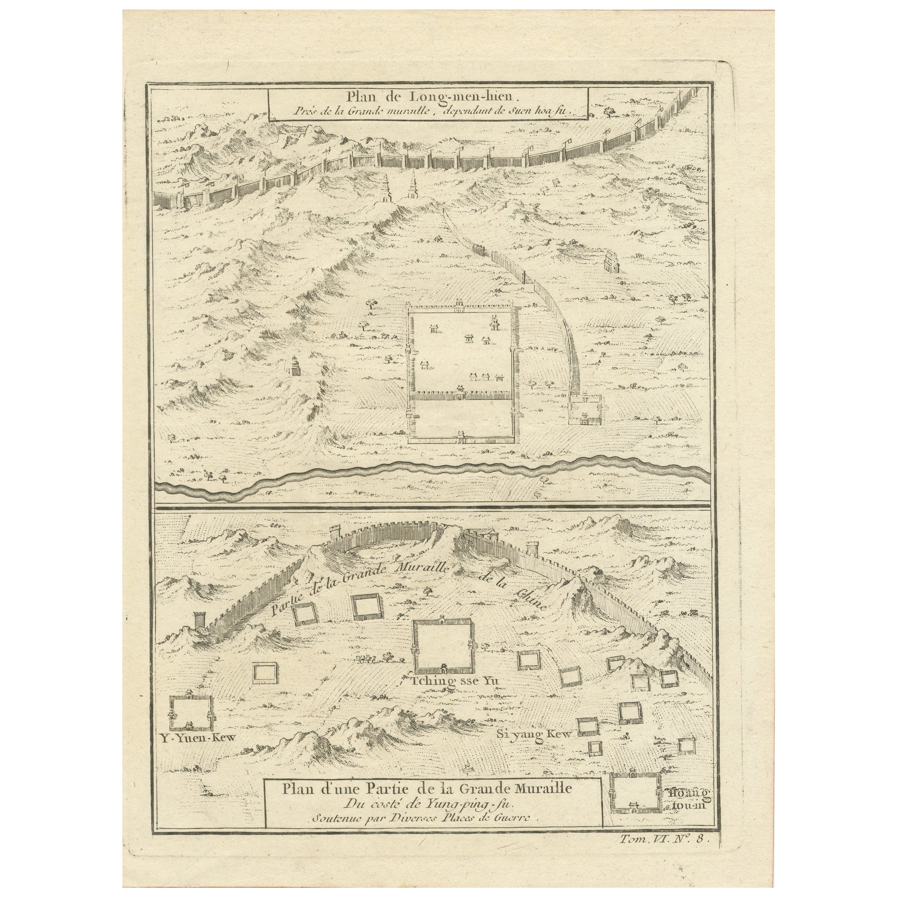
1749 Jacques Nicolas Bellin Map of the Great Wall of China Near Kiang-nan fu
Located in Langweer, NL
This original antique image is an historical map by Jacques Nicolas Bellin, depicting the Great Wall of China as it was understood in the mid-18th century.
The map includes French ...
Category
Antique 1750s Prints
Materials
Paper
$138 Sale Price
20% Off
Antique Map of Celebes 'Sulawesi, Indonesia' by Bellin, ciarca 1755
By Jacques-Nicolas Bellin
Located in Langweer, NL
Antique map titled 'Carte de l'Isle Celebes ou Macassar'. Map of Celebes (Sulawesi, Indonesia), showing Makassar, which was the most important trading city of eastern Indonesia in th...
Category
Antique Mid-18th Century European Maps
Materials
Paper

$138 Sale Price
20% Off
Antique Map of Tartary and Northeast Asia by Bellin, circa 1750
By Jacques-Nicolas Bellin
Located in Langweer, NL
Antique map titled 'Carte de la Tartarie Occidentale'. Map of Tartary and northeast Asia, from Lake Baykal, Partie du Siberia in the north, Pays des Kalkas at the center, as well as ...
Category
Antique Mid-18th Century European Maps
Materials
Paper

$129 Sale Price
20% Off