Want more images or videos?
Request additional images or videos from the seller
1 of 10
Occasus Ortus: An Astronomical Measuring Device for Angular Precision, c.1780
Price:$250.57
$383.56List Price
About the Item
- Dimensions:Height: 10.67 in (27.1 cm)Width: 8.43 in (21.4 cm)Depth: 0 in (0.02 mm)
- Materials and Techniques:Paper,Engraved
- Place of Origin:
- Period:1780-1789
- Date of Manufacture:ca.1780
- Condition:Condition: Good, given age. General age-related toning and/or occasional minor defects from handling. Please study scan carefully.
- Seller Location:Langweer, NL
- Reference Number:Seller: PCT-58713 1stDibs: LU3054326575402
About the Seller
5.0
Recognized Seller
These prestigious sellers are industry leaders and represent the highest echelon for item quality and design.
Platinum Seller
Premium sellers with a 4.7+ rating and 24-hour response times
Established in 2009
1stDibs seller since 2017
2,795 sales on 1stDibs
Authenticity Guarantee
In the unlikely event there’s an issue with an item’s authenticity, contact us within 1 year for a full refund. DetailsMoney-Back Guarantee
If your item is not as described, is damaged in transit, or does not arrive, contact us within 7 days for a full refund. Details24-Hour Cancellation
You have a 24-hour grace period in which to reconsider your purchase, with no questions asked.Vetted Professional Sellers
Our world-class sellers must adhere to strict standards for service and quality, maintaining the integrity of our listings.Price-Match Guarantee
If you find that a seller listed the same item for a lower price elsewhere, we’ll match it.Trusted Global Delivery
Our best-in-class carrier network provides specialized shipping options worldwide, including custom delivery.You May Also Like
Original Antique Map of South America. C.1780
Located in St Annes, Lancashire
Great map of South America
Copper-plate engraving
Published C.1780
Two small worm holes to left side of map
Unframed.
Category
Antique Early 1800s English Georgian Maps
Materials
Paper

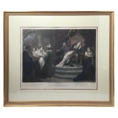
Stipple Engraving of "Shakspeare. / Measure for Measure / Act V, Scene I." 1796
Located in Lambertville, NJ
Stipple engraving of "SHAKSPEARE. / Measure For Measure / ACT V, SCENE I." England, 1796 by Thomas Kirk (English painter and printmaker, 1765-1797) and John Boydell (1720-1804) & Jos...
Category
Antique Late 18th Century English Prints
Materials
Glass, Giltwood, Paper
$1,950
H 30 in W 34 in D 1 in
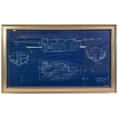
John Alden Blueprint No. 583 of an Auxiliary Cruising Yawl
Located in Norwell, MA
Exceptional and stunning original yacht blueprint from John G Alden of Boston. The legend panel reads “Auxiliary Cruising Yawl” cabin plan. March 21, 1934. C.A. Alberg John G. Alden ...
Category
Vintage 1930s Nautical Objects
Materials
Paper
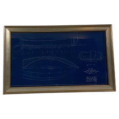
Original Blueprint for the Sailing Dingy “Burp” by John Alden
Located in Norwell, MA
Blueprint from John G Alden, naval architect, 131 State St, Boston. Plan is for No. 559, a class A sailing dingy named "Dunk.” Showing all hull lines in great detail. Rich blue color...
Category
Vintage 1930s Nautical Objects
Materials
Paper
Original Program for Nantucket Stage Production Dracula, Signed by Edward Gorey
Located in Nantucket, MA
Original program for the Nantucket Stage Company Production of "Dracula", signed by Edward Gorey, 1973. The Nantucket Stage Company (which became the Stra...
Category
Vintage 1970s American Post-Modern Historical Memorabilia
Materials
Paper
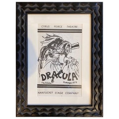
$1,475
H 13.5 in W 10.25 in D 1 in
1957-1962, Rare Georges Braque 'Au Vent d'Arles' Archive Books and Lithographs
By Georges Braque
Located in Paris, FR
Extremely rare set of Georges Braque archives maquettes books and lithographs created with the publisher 'Au Vent d'Arles', Paris.
The set is composed with:
- L'Ordre des Oiseaux (...
Category
Vintage 1950s French Modern Books
Materials
Paper
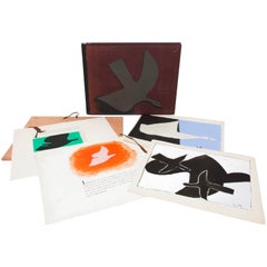
$14,982
H 17.72 in W 21.66 in D 1.97 in
1844 French Antique Nautical Portolano of Golfe De St. Drely by Antoine Roux
By Antoine Roux
Located in Milan, IT
Antique portolano, nautical map of Golfe De St. Drely engraved on a copper plate by Antoine Roux, Marseille France 1844, from his work Recueil des principaux plans des ports et de Ra...
Category
Antique 1840s French Nautical Objects
Materials
Paper

$539
H 12.21 in W 14.97 in D 0.79 in
Robert Cenedella 'American, B.1940', Le Cirque NY, 1st Edition Print 52/100
Located in Bridgeport, CT
Original unframed lithograph by Robert Cenedella (American, b. 1940) for Le Cirque 2000.
The artist painted famous patrons and friends of the world famous Le Cirque restaurant...
Category
21st Century and Contemporary American Hollywood Regency Prints
Materials
Paper
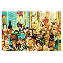
$200 / item
H 21 in W 32 in D 0.07 in
Presenting Stefano Della Bella Stefano Della Bella, by Phyllis Massar, 1st Ed
Located in valatie, NY
Presenting Stefano Della Bella by Stefano Della Bella, by Phyllis Dearborn Massar. Published by Metropolitan Museum of Art, 1971. 1st Ed hardcover with dust jacket. 141 pp. Profusely...
Category
Vintage 1970s American Books
Materials
Paper
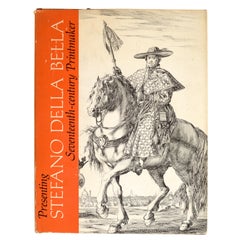
$65
H 11.25 in W 8.75 in D 0.75 in
More Massachusetts Towns, Illustrated with Wood Engravings of 53 Mass. Towns
Located in valatie, NY
More Massachusetts Towns, illustrated with wood engravings of fifty-three Massachusetts Towns, drawn in 1840 by J. W. Barber. Commentary by Ivan Sandrof, and a special foreword by Mr...
Category
Vintage 1960s American Books
Materials
Paper
$125
H 8.25 in W 7 in D 0.5 in
More From This Seller
View AllAntique World Map with Astronomical Spheres by Pierre Mortier, Amsterdam, c.1700
Located in Langweer, NL
Antique World Map with Astronomical Spheres by Pierre Mortier, Amsterdam, circa 1700
This fascinating antique world map titled "Carte générale du monde, ou description du monde terr...
Category
Antique 17th Century French Maps
Materials
Paper

$880 Sale Price
25% Off
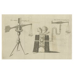
Antique Print of Two Balances for Weighing Fire and Air, c.1780
Located in Langweer, NL
Antique print titled 'Balance for weighing air - Balance for weighing fire'. Copper engraving of two balances. Source unknown, to be determined.
Artists and Engravers: Anonymous
...
Category
Antique 18th Century Prints
Materials
Paper
$182 Sale Price
20% Off
Antique Map of Sumatra, Indonesia 'c.1780'
Located in Langweer, NL
Antique map titled 'Neue Karte von der Insel Sumatra'. Extremely rare map of Sumatra, Indonesia. Published circa 1780.
Category
Antique Late 18th Century Maps
Materials
Paper

$2,517 Sale Price
40% Off
Antique Map of Europe by R. Bonne, 1780
Located in Langweer, NL
A fine example of Rigobert Bonne and Guilleme Raynal’s 1780 map of Europe. Drawn by R. Bonne for G. Raynal’s Atlas de Toutes les Parties Connues du Globe Terrestre, Dressé pour l'His...
Category
Antique Late 18th Century French Maps
Materials
Paper

$151 Sale Price
30% Off
Antique Map of West Africa by R. Bonne, 1780
Located in Langweer, NL
Antique map titled 'Partie Occidentale De L'Ancien Continent Depuis Lisbonne Jusqua La Riviere De Sierra Leona Avec L'Isle de Madere, les Isles Canaries et celles Du Cap Verd'. Parts...
Category
Antique Late 18th Century French Maps
Materials
Paper
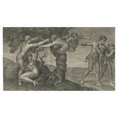
Rare Antique Print of Temptation and Expulsion, c.1780
Located in Langweer, NL
Antique print religion titled 'Tulit Igitur Mulier de Fructu Illius, et Comedit (..)'. This print depicts Temptation and Expulsion. Originates from 'Frescoes in the Sistine Chapel'.
...
Category
Antique 18th Century Prints
Materials
Paper