Netherlands
to
286
405
1,136
490
25,957
13,572
12,548
9,544
8,807
6,877
6,174
5,636
4,557
4,281
3,846
3,405
3,258
2,667
2,313
1,813
1,277
1,182
1,130
793
780
665
649
645
547
529
442
436
413
405
391
375
332
309
278
248
218
183
176
169
169
167
163
148
141
139
118
115
90
90
77
76
72
70
68
48
48
36
35
34
25
20
3
3
2
2
2
Period: Late 17th Century
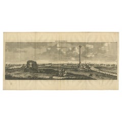
Copper-Line Engraving by Cornelius de Bruyn of Alexandria in Egypt, c.1690
Located in Langweer, NL
Artist: Cornelis de Bruijn (or de Bruyn); 1652 – 1726/7 was a Dutch artist and traveler. He made two large tours and published illustrated books with his observations of people, buil...
Category
Late 17th Century Antique Netherlands
Materials
Paper
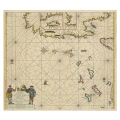
Original Antique Sea Chart of the Northern Part of Hispaniola, Western Cuba
Located in Langweer, NL
Antique map titled 'Pas kaart van de Noord Kust van Espaniola (..)'. Beautiful sea chart of the northern part of Hispaniola, western Cuba. The map includes the Turks & Caicos Islands and southern part of the Bahamas. Shows Guanahami or S. Salvador. Guanahani is an island in the Bahamas that was the first land in the New World sighted and visited by Christopher Columbus' first voyage, on October 12, 1492. It is not known precisely which island it was, and several theories have been put forth by historians. Guanahani is the native Taíno name; Columbus called it San Salvador. Originates from 'De Nieuwe Groote Lightende Zee-Fakkel'. Published by J. van Keulen, circa 1684.
The Van Keulens were a family of chartmakers and publishers. The firm, In de Gekroonde Lootsman (In the Crowned Pilot), was founded in 1678 by Johannes van Keulen (1654-1715). Van Keulen originally registered his business as a vendor of books and instruments (specifically cross-staffs). In 1680, however, he gained a privilege from the States of Holland and West Friesland for the publication of pilot guides and sea atlases.
In that year, van Keulen released his Zee-Atlas (Sea Atlas), which secured him a name in the competitive maritime publishing market. In 1681, he published the first volume of Nieuwe Lichtende Zee-Fakkel (New Shining Sea Torch). This would be the first of an eventual five volumes originally published between 1680 and 1684. A sixth volume was added in 1753. The Zee-Fakkel won van Keulen lasting fame. The atlas had charts compiled by Claes Jansz Vooght and artwork from Jan Luyken...
Category
Late 17th Century Antique Netherlands
Materials
Paper
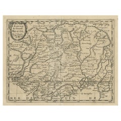
Old Map of the Mughal Empire, Persia in the West to Lake Chimay etc., ca.1685
Located in Langweer, NL
Antique map titled 'L'Empire du Grand Mogol'. Old map of India and Central Asia.
The map extends from Persia in the West to Lake Chimay and the Bay of Bengal...
Category
1680s Antique Netherlands
Materials
Paper
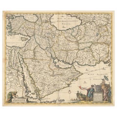
Circa 1691 Frederick de Wit Map: Middle East with Arabia, Persia & More
Located in Langweer, NL
Circa 1691 Frederick de Wit Map: Middle East with Arabia, Persia & More
This exquisite hand-colored map, circa 1691, by Frederick de Wit, illustrates the Middle East, spanning from Turkey and Egypt to Afghanistan, with a detailed representation of the Arabian Peninsula.
The map's detailing in Arabia is based on Nicolas Sanson's influential 1654 map, which was one of the most accurate and detailed depictions of the region up to the mid-seventeenth century.
The decorative title cartouche is richly adorned with images of exotic figures, animals, and a merchant ship, symbolizing the region's historical trade importance. Additionally, a mapmaker is shown working with traditional tools, adding a touch of authenticity to the cartographic art.
This is the fourth state of the map, published between 1691 and 1696. The map measures 21.8 inches in width by 18.5 inches in height, featuring a sharp impression, with minimal staining and a carefully repaired centerfold separation at the bottom.
Keywords:
- Middle East historical map
- Frederick de Wit map
- 17th century maps
- Arabian Peninsula map
- Persia (Iran) map
- Turkey and Egypt map...
Category
1690s Antique Netherlands
Materials
Paper
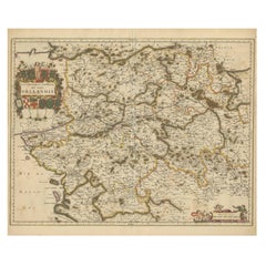
Hand-Colored 17th-Century Map of Orléanais in France by Frederik De Wit c. 1688
Located in Langweer, NL
Title: Hand-Colored 17th-Century Map of Orléanais by Frederik De Wit c. 1688
Description: This beautifully crafted map, "Gouvernement General du Pays Orléanois," illustrates the Orl...
Category
1680s Antique Netherlands
Materials
Paper
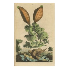
Botanical Illustration of Soursop (Annona muricata) from Munting’s 1696 Herbal
Located in Langweer, NL
This antique print, titled "Guanabanus Folio Ficulneo," illustrates the Soursop, or Annona muricata, a fruit native to tropical regions of the Americas, particularly valued for its s...
Category
1690s Antique Netherlands
Materials
Paper
Large Cube Shaped Glass Floor and Table Light by Carlo Nason, 1970
By Carlo Nason
Located in Rijssen, NL
Wonderful high-end large cube glass table or floorlamp. Thick textured glass. Designed by Carlo Nason, 1970.
This cube is a real eyecatcher and fits in various interiors. Illuminate...
Category
1670s Austrian Mid-Century Modern Antique Netherlands
Materials
Brass
Coast of Northumberland, England, Incl the Holy & Farne Islands, Etc, 1693
Located in Langweer, NL
Antique map titled 'Holy Island, Staples and Barwick.'
A map of the coast of Northumberland, England. This map includes Holy Island, Buckton, Sunderland and the Farne Islands. Th...
Category
1690s Antique Netherlands
Materials
Paper
A Chinese Kangxi Period Porcelain Blanc de Chine Foo Dog, circa 1680
Located in London, GB
A Chinese Kangxi Period Porcelain Blanc de Chine Foo Dog, circa 1680.
Very well modelled to show the male dog placing h...
Category
1680s Antique Netherlands
Materials
Porcelain
View of Bartanico in the Aegean Archipelago with Fortifications and Ships, 1680
Located in Langweer, NL
Title: View of Bartanico in the Aegean Archipelago with Fortifications and Ships, ca. 1680
Description: This copperplate engraving depicts a striking view of Bartanico (possibly P...
Category
1680s Antique Netherlands
Materials
Paper
Botanical Illustration of Sesame Plant (Sesamum indicum) - Munting’s 1696 Herbal
Located in Langweer, NL
This antique print, titled "Sesamum Persicum Trilobatum Foetidum," depicts the Sesame plant (Sesamum indicum), known for its seeds and oil. Sesame is one of the oldest oilseed crops,...
Category
1690s Antique Netherlands
Materials
Paper
1692 Jacq. Peeters Map: East Indies, Indonesia, Japan, Philippines and Singapore
Located in Langweer, NL
1692 Jacques Peeters Map: East Indies, Indonesia & Japan with Unique Inset
This hand-colored map from 1692, created by Jacques Peeters, captures the islands of Indonesia, the Philippines, and features a unique inset of Japan.
It closely resembles Nicolas de Fer's map and is primarily based on Sanson's influential maps. The map meticulously details cities, smaller settlements, rivers, mountain chains, and forests, offering a comprehensive view of the region's geography.
The inset map of Japan stands out due to its distinctive shape and influences, reflecting different cartographic sources. Notable features include the marked equator and detailed latitude and longitude indications on the borders.
The map measures 6.5 inches in width by 5.5 inches in height and is in excellent condition, with a dark impression, slight toning, and a minor centerfold crease.
Keywords:
- East Indies map
- Indonesia historical map
- Philippines map...
Category
1690s Antique Netherlands
Materials
Paper
Antique Map of the North Pole by V.M. Coronelli, circa 1692
By Vincenzo Coronelli
Located in Langweer, NL
Globe gore by Vincenzo Maria Coronelli shows the North Pole with the coasts of Canada, Greenland, Scandinavia and Siberia, and is decorated with pictorial scenes of bear, seal and wh...
Category
Late 17th Century Antique Netherlands
Materials
Paper
Daily Life in Brazil in the early 17th Century on a Copper Engraving by Montanus
Located in Langweer, NL
"Daily Life in Brazil"
This striking copper engraving, part of Arnoldus Montanus' "Die Unbekannte Neue Welt oder Beschreibung des Welt-teils Amerika und des Sud-Landes", presents a ...
Category
1670s Antique Netherlands
Materials
Paper
The Martyrdom of Secular Priests and One Benedictine Monk by Parlement, c.1680
Located in Langweer, NL
The engraving depicts a scene of execution involving multiple priests, likely reflecting religious persecution in England. Here is a detailed analysis, including a translated version...
Category
1680s Antique Netherlands
Materials
Paper
Territorium Francofurtens – Moses Pitt’s 17th-Century Map of Frankfurt
Located in Langweer, NL
Title: Territorium Francofurtens – Moses Pitt’s 17th-Century Map of Frankfurt
Description:
This rare 17th-century map, titled Territorium Francofurtens, was published by Moses ...
Category
1690s Antique Netherlands
Materials
Paper
Biblical Antique Fireback or Backsplash
Located in Haarlem, Noord-Holland
A nice and tall decorative fireback or backsplash.
This was originally a sides of an old cast iron stove from the 17th century.
In the early 19th century these decorative stove whe...
Category
Late 17th Century Dutch Antique Netherlands
Materials
Iron
Circa 1686 Daniel Stoopendaal Map: Biblical Sites from Paradise to Canaan
Located in Langweer, NL
Circa 1686 Daniel Stoopendaal Map: Biblical Sites from Paradise to Canaan
This circa 1686 hand-colored map by Daniel Stoopendaal, titled "De Gelegentheyt van 't Paradys en 't Landt Canaan," beautifully illustrates the Middle East, extending from the Mediterranean to the Persian Gulf.
The map features numerous Biblical locations, such as the Garden of Eden, the wanderings of the Children of Israel, and the story of Jonas and the whale.
It is adorned with elaborate decorations, including a banner-style title cartouche and four corner vignettes depicting scenes from Genesis: Paradise, the creation of Adam and Eve, Eve offering the apple, and their expulsion from Eden.
The bottom center showcases a dramatic portrayal of Noah's Ark. Measuring 18.3 inches wide by 11.9 inches high, this first state map includes Dutch text on the reverse and is in good condition, with a crisp impression, light toning along the centerfold, and a small chip in the bottom margin.
Keywords:
- Daniel Stoopendaal map
- Biblical map
- Garden of Eden
- Land of Canaan
- Middle East historical map
- Noah's Ark map
- Adam and Eve
- 17th-century Bible...
Category
1680s Antique Netherlands
Materials
Paper
Botanical Illustration of White Turmeric (Curcuma zedoaria) by Blackwell, 1696
Located in Langweer, NL
This antique print, titled "Zedoaria," depicts the Curcuma zedoaria, also known as zedoary, white turmeric, or kentjur. The plant is a member of the ginger family, known for its medi...
Category
1690s Antique Netherlands
Materials
Paper
Rare Hand-Colored Map of of the Wine Region Burgundy in France by De Wit, c.1688
Located in Langweer, NL
Title: New Description of the Duchy of Burgundy - Frederik De Wit c. 1688
Description: This exquisite map of the Duchy of Burgundy, published after 1688, is a fascinating example of...
Category
1680s Antique Netherlands
Materials
Paper
+17th century Dutch renaissance two door portal cabinet with exotic carvings
Located in Casteren, NL
On offer here is a very rare Dutch cabinet made of the finest European summer oak in the tradition of the Dutch Renaissance during the “Dutch Golden...
Category
Late 17th Century Dutch Renaissance Antique Netherlands
Materials
Ebony, Oak
Antique Botany Print of Origanum Syriacum by Dodart, circa 1680
Located in Langweer, NL
Antique botany print titled 'Maiorana Syriaca sive Marum Syriacum'. Original antique print of origanum syriacum, also known as bible hyssop, Biblical-hyssop, Lebanese oregano or Syri...
Category
Late 17th Century French Antique Netherlands
Materials
Paper
Set of 2 Antique Horse Riding Prints
Located in Langweer, NL
Set of 2 antique horse riding prints. Published circa 1680.
Category
Late 17th Century Antique Netherlands
Materials
Paper
Original Hand-coloured Antique Map of Pomerania by Sanson '1684'
By Nicolas Sanson
Located in Langweer, NL
Antique map titled 'Le Duche de Pomeranie divise en ses Principales Parties (..)'. Large map of Pomerania. Pomerania is a historical region on the southern shore of the Baltic Sea in...
Category
Late 17th Century Antique Netherlands
Materials
Paper
Original Antique Map of the Philippines, Malaysia, Indonesia, Singapore, c.1690
Located in Langweer, NL
Antique map titled 'Isole dell' Indie, diuise in Filippine, Molucche e della Sonda'.
Old map of the Philippines, Malaysia, Indonesia, Singapore, Northern Australia and contiguous i...
Category
1690s Antique Netherlands
Materials
Paper
Map of the Provence in Southern France, Original Old Engraving by De Wit c. 1688
Located in Langweer, NL
Title: Provence Map - Hand-Colored 17th-Century Engraving by Frederik De Wit c. 1688
Description: This captivating map, "Gouvernement de Provence," depicts the Provence region of so...
Category
1680s Antique Netherlands
Materials
Paper
Baroque Grandeur: The Rosersberg Palace Gardens in Swidde's 1695 Engraving
Located in Langweer, NL
The image is an original antique copperplate engraving by Swidde, completed in 1695. The scene is a meticulous depiction of an elegant palace and its formal gardens, rendered in the ...
Category
1690s Antique Netherlands
Materials
Paper
Rare 17th-Century Map of Dauphiné in Southeastern France by F. De Wit, ca.1688
Located in Langweer, NL
Title: Rare Hand-Colored 17th-Century Map of Dauphiné by Frederik De Wit c. 1688
Description: This captivating 17th-century map of Dauphiné, titled "Nova et Accurata Delphinatus Vul...
Category
1680s Antique Netherlands
Materials
Paper
Botanical Illustration of the Castor Oil Plant (Ricinus communis), 1696
Located in Langweer, NL
The print titled "Ricinus Americanus Major Rubicundus" depicts the Ricinus communis plant, commonly known as the castorbean or castor-oil-plant. This plant is notable for its large, ...
Category
1690s Antique Netherlands
Materials
Paper
Etching of Agostino Chigi's Coat of Arms and View of Rome, by C.Fantetti, c.1690
Located in Langweer, NL
Etching of Agostino Chigi's Coat of Arms and View of Rome, by Cesare Fantetti
This exquisite 17th-century etching, created by Italian printmaker Cesare Fantetti between 1653 and 169...
Category
1690s Antique Netherlands
Materials
Paper
1684 Mallet Map of Amazon River & Kingdom of Amazons – Hand Colored, Miniature
Located in Langweer, NL
This map, titled 'Royaume des Amazones', was created by Alain Manesson Mallet and published in 1684 in a German edition of *Beschreibung des Gantzen Welt-Kreisses*, a renowned work d...
Category
1680s Antique Netherlands
Materials
Paper
Rare Hand-Colored Map of Lorraine and Barrois, France by Frederik De Wit c. 1688
Located in Langweer, NL
Title: Rare Hand-Colored Map of Lorraine and Barrois by Frederik De Wit c. 1688
Description: This remarkable 17th-century map, titled "Generalis Lotharingiae Ducatus," offers a deta...
Category
1680s Antique Netherlands
Materials
Paper
Panoramic View of Isfahan in 17th Century Persia by J.C. Haffner, ca.1690
Located in Langweer, NL
Panoramic View of Isfahan in the Late 17th Century by J.C. Haffner
The translation of the German text on the engraving:
"A. The Meidan or Great Market and Promenade Square in front...
Category
1690s Antique Netherlands
Materials
Paper
Vibyholm Castle in Sweden: A Baroque Gem in Dahlbergh's Collection, ca.1675
Located in Langweer, NL
Title: "Vibyholm Castle: A Baroque Gem in Dahlbergh's Collection"
Description: This splendid hand-colored engraving from the 1670s features Vibyholm Castle, a notable example of Swe...
Category
Late 17th Century Antique Netherlands
Materials
Paper
Rare Hand-Colored Map of Champagne and Brie, France, by Frederik De Wit c. 1688
Located in Langweer, NL
Title: Rare Hand-Colored Map of Champagne and Brie by Frederik De Wit c. 1688
Description: This exquisite 17th-century map, "Champagne et Brie," beau...
Category
1680s Antique Netherlands
Materials
Paper
1690 Frederick de Wit Sea Chart of Hudson Bay, Baffin Bay and Greenland
Located in Langweer, NL
Title: c. 1690 Frederick de Wit Sea Chart of Hudson Bay, Baffin Bay, and Greenland - Engraved by Romeyn de Hooghe
This striking sea chart by Frederick de Wit, titled "Septemtrionali...
Category
1690s Antique Netherlands
Materials
Paper
1767 D’Anville Map of the Holy Land: Ancient Divisions and Biblical Geography
Located in Langweer, NL
Ancient Map of Palestine or the Holy Land by D'Anville (1767)
This detailed map, created by the renowned French cartographer Jean Baptiste Bourguignon d'Anville in 1767, depicts the...
Category
1670s Antique Netherlands
Materials
Paper
Antique Map of the Island of Djerba by Coronelli '1691'
Located in Langweer, NL
Antique map titled 'Isola e Castello di Gerbi'. Original antique map of the Island of Djerba, Tunisia, in Africa. Includes an inset of the Djerba Castle in upper right. This map orig...
Category
Late 17th Century Antique Netherlands
Materials
Paper
17th Century Nautical Chart of Skagerrak and Øresund by Johannes van Keulen
Located in Langweer, NL
This map titled *Pascaret van Schager-Rack de Bælt en de Sondt* was created by the prominent Dutch cartographer Johannes van Keulen and published in Amsterd...
Category
Late 17th Century Antique Netherlands
Materials
Paper
Rare Original Antique Ptolemy Map of Ceylon, Present Day Sri Lanka
Located in Langweer, NL
Original antique map titled 'Tab XII Asiae Taprobanam (..)'. For this map of Toprobana (Sri Lanka), Ptolemy drew on the accounts of travelers and sailors and though the information was secondhand and often inaccurate, it represented the most advanced account of the world's geography at that time. This map depicts the island with the typical misconceptions of the period with the enlarged island straddling the Equator and nearly divided by a ridge of mountains. A small part of India is incorrectly shown in the northeast corner of the map and a spurious coastline labeled Gangem fills the upper right corner. The stipple engraved sea contains an oriental ship...
Category
Late 17th Century Antique Netherlands
Materials
Paper
Dutch Conquest of Rio Grande, Brazil (1633) Under Prince Frederick Hendrick
Located in Langweer, NL
The image is an engraving titled “VEROVERINGE VAN RIO GRANDE IN BRASIL ANNO 1633.” This historical print depicts the Dutch conquest of Rio Grande in Brazil, known today as Natal, dur...
Category
1690s Antique Netherlands
Materials
Paper
Allegorical Frontispiece of Rome's Ruins, Pieter van der Aa & F. Halma, 1696
Located in Langweer, NL
This engraving is an allegorical frontispiece featuring a depiction of the ruins of ancient Rome, emphasizing the enduring legacy of the city's grandeur through its remnants. The com...
Category
1690s Antique Netherlands
Materials
Paper
Beautiful View of the Island of Rhodes, Greece, depicting the Old Town with Fort
Located in Langweer, NL
Antique print Greece titled 'Rhodus'. Beautiful view of the Island of Rhodes, Greece, depicting the Old Town with fortifications beside a row of w...
Category
1690s Antique Netherlands
Materials
Paper
Antique Sea Chart of Hudson Bay and Arctic Canada by Van Keulen, circa 1681
Located in Langweer, NL
Antique map titled 'Pascaarte vande Noorderzee Custen van America (..)'. Sea chart of Hudson Bay and Arctic Canada. Compass roses, loxodromic lines, and ships decorate the oceans and...
Category
Late 17th Century Antique Netherlands
Materials
Paper
A Handsome & Detailed Map of the Duchy of Mecklenburg & Pomerania, Germany, 1680
Located in Langweer, NL
Antique map titled 'Ducatus Meklenburgicus in quo sunt Ducatus Vandaliae et Meklenburgi Ducatus et Comitatus Swerinensis.'
A handsome and detailed map of the Duchy of Mecklenburg...
Category
1680s Antique Netherlands
Materials
Paper
“Mandarin” Pendant Lamp by Michael Bang for Holmegaard/Royal Copenhagen, 1980's
By Michael Bang, Royal Copenhagen, Holmegaard
Located in Steenwijk, NL
This very nice pendant lamp was designed by Michael Bang for Holmegaard/Royal Copenhagen in Denmark in the 1980's. It is made of white opaline glass, which gives beautiful warm and p...
Category
1680s Danish Mid-Century Modern Antique Netherlands
Materials
Opaline Glass
Original Antique Hand- Map of Africa by Allard '1697'
Located in Langweer, NL
Antique map titled 'Novissima et Perfectissima Africae (..)'. Beautiful large map of Africa. This is the 3rd state of the map, with climate notation add...
Category
Late 17th Century Antique Netherlands
Materials
Paper
Botanical Illustration of Cardamom Plant (Cardamomum majus arborescens) , 1696
Located in Langweer, NL
This antique print, titled "Cardamomum majus arborescens," illustrates the Cardamom plant, known for its aromatic seeds, which are commonly used as a spice in both culinary and medic...
Category
1690s Antique Netherlands
Materials
Paper
Baroque Allegorical Engraving with Noble Coat of Arms, circa 1690
Located in Langweer, NL
Title: "Allegorical Tribute to Cardinal Giovanni Francesco Negroni"
Description: This intricate engraving features an allegorical landscape dedicated to Cardinal Giovanni Francesco ...
Category
1690s Antique Netherlands
Materials
Paper
Fortified Island in the Aegean Archipelago with Ships at Sea, circa 1680
Located in Langweer, NL
Title: Fortified Island in the Aegean Archipelago with Ships at Sea, circa 1680
Description:
This copperplate engraving depicts a dramatic scene of a fortified island rising f...
Category
1680s Antique Netherlands
Materials
Paper
Antique Engraving with a Plan of Rhodes, Greece, 1688
Located in Langweer, NL
Description: Antique map, titled: 'Rhodos.' - Plan of Rhodes, Greece. This map originates from 'Nauwkeurige Beschrijving der eilanden in de in de Archipel der Middellantsche Zee', by...
Category
1680s Antique Netherlands
Materials
Paper
Rare Print of Genesis in the Old Testament; Adam and Eve Eating the Apple, 1674
Located in Langweer, NL
Antique print, titled: 'Lussa dei sumpto violantur ab arbore pomo, Efficit hoc tacitis vipera saeua dolis.'
This original antique print shows a scene from Genesis in the Old Test...
Category
1670s Antique Netherlands
Materials
Paper
Map of Languedoc-Roussillon and Provence in France and Piedmont in Italy, c1680
Located in Langweer, NL
Title: Antique map titled 'La basse Partie du Gouvernement de Languedoc, environne des Frontiers des Gouverns de Provence, de Dauphine de Lyonnais et de Guienne et Gascogne ; Les Fro...
Category
1680s Antique Netherlands
Materials
Paper
Antique Map of the Cape Verde Islands, Africa, ca.1670
Located in Langweer, NL
Antique map titled 'Pascaert van de Soute Eylanden ofte Ilhas de Cabo Verde'.
This map depicts the Cape Verde Islands (Africa). Islands titled 'Ile de B...
Category
1670s Antique Netherlands
Materials
Paper
Antique Map of Japan by A.M. Mallet, 1683
Located in Langweer, NL
A charming late 17th century French map with a very decorative title cartouche showing trumpet-blowing cherubs, by Allain Manneson Mallet (1630-1706), a well traveled military engine...
Category
Late 17th Century Antique Netherlands
Materials
Paper
Mecha in Arabia – Engraving by Gaspar Bouttats after Jan Peeters, Antwerp, 1680
Located in Langweer, NL
Title: Mecha in Arabia – Engraving by Gaspar Bouttats after Jan Peeters, Antwerp, circa 1680
Description: This copperplate engraving depicts a detailed view of Mecca in Arabia, h...
Category
1680s Antique Netherlands
Materials
Paper
Dardanelles Strait, with a Perspective of the City of Constantinople, 1693
Located in Langweer, NL
Title: "Veue des Dardanelles de Constantinople, 1693"
Description: This historical copper engraving, crafted by Nicholas de Fer between 1646 and 1720 in Paris, is a remarkable depic...
Category
1690s Antique Netherlands
Materials
Paper
Port Scene at Ladimiti in the Aegean Archipelago with Fortifications, ca. 1680
Located in Langweer, NL
Title: Port Scene at Ladimiti in the Aegean Archipelago with Fortifications, ca. 1680
Description: This copperplate engraving depicts a bustling port scene at Ladimiti (likely Lem...
Category
1680s Antique Netherlands
Materials
Paper
Title page from "Views of the Dardanelles", engraved by Jacob Peeters, ca. 1680
Located in Langweer, NL
Title:
Diverse viste delli Dardanelli del Strecio, come delle Città e Castelli nel Arcipelago – Title page of the series, engraved by Jacob Peeters after Jan Peeters, Antwerp, circ...
Category
1680s Antique Netherlands
Materials
Paper
The Dardanelles with Fortified Towers and Maritime Activity, ca. 1680
Located in Langweer, NL
Title: The Dardanelles with Fortified Towers and Maritime Activity, ca. 1680
Description: This copperplate engraving portrays the Dardanelles Strait with its imposing fortified to...
Category
1680s Antique Netherlands
Materials
Paper
